Showing 317 items matching " excavations"
-
 Bendigo Historical Society Inc.
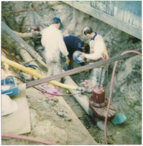
Photograph - CASTLEMAINE GAS COMPANY COLLECTION: PHOTO EXCAVATION
Unknown Location and Date - ExcavationPolaroidorganisation, industry, gas and fuel -
 Ringwood and District Historical Society
Photograph, Excavation, Ringwood baths 1934
Written on front of photograph, "Excavation, Ringwood baths". -
 Glenelg Shire Council Cultural Collection
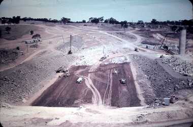
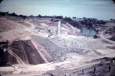
Slide - Slide - Construction Portland/Cashmore Airport, c. 1980
Coloured slide. Excavation in centre, with water in bottom. Concrete retaining wall in foreground. Roller on left edge of excavation. Pump and drum on ground near top of retaining wall. -
Glenelg Shire Council Cultural Collection
Slide - Slide - Cashmore Airport, Portland, 1980s
Coloured slide. Road making equipment working in bottom of excavation.portland airport, cashmore, engineering, air travel, construction -
 Bendigo Historical Society Inc.
Photograph - CASTLEMAINE GAS COMPANY COLLECTION: PHOTO BENDIGO CREEK
Bendigo creek. Deep excavation at both sides of water channel.Kodakbendigo, waterworks, bendigo creek -
Port Melbourne Historical & Preservation Society
Photograph - Sketch, Excavation of the Coode Canal and Reclaiming Land, 1880
Photograph of Sketch - Excavation of the Coode Canal And Reclaiming Land. 1880engineering - canals and drainage -
Whitehorse Historical Society Inc.
Newspaper - Article, Open Season - Schwerkolt wine cellar, 11/07/1973
'Open season' : article on excavation of the Schwerkolt Cottage wine cellar.wine cellars, schwerkolt cottage, s. wynn & co ltd. -
![Photograph - Construction of the F19 [Eastern Freeway], Ron Setford, March 1973](/media/collectors/550653872162f11fb04854aa/items/67fb2e63a8240b7bcaf33ce5/item-media/67fb2e83a8240b7bcaf340a9/item-fit-380x285.jpg) Kew Historical Society Inc
Kew Historical Society IncPhotograph - Construction of the F19 [Eastern Freeway], Ron Setford, March 1973
Ron Setford and his wife Grace Setford lived in Tanner Avenue, East Kew, from c.1946 to c.1995. A keen photographer, he recorded the changing face of Kew over a 20 year period. Apart from 30 photographs of built structures and places in Kew dating from 1960 and 1961, 145 of his 35mm colour slides chronicle the development of the F19 (later renamed Eastern) Freeway through the Yarra Valley in Kew over a five year period from c.1972 to c.1977. This important collection was donated to the Society by his granddaughter in 2025.This collection of 175 35mm slides is of local and statewide significance, owing to its subject matter, particularly the major development of road transport infrastructure during the 1970s with the construction of the Eastern Freeway. The photographer also took care to annotate and date most of his slides which enable the researcher to pinpoint temporal and spatial locations."Eastern Freeway / Start Belford Rd excavation 3/73"ron setford, eastern freeway, f19 freeway -
![Photograph - Construction of the F19 [Eastern Freeway], Ron Setford, May 1973](/media/collectors/550653872162f11fb04854aa/items/67ff9c893b378d43a2a8b2a0/item-media/67ff9ca63b378d43a2a8b531/item-fit-380x285.jpg) Kew Historical Society Inc
Kew Historical Society IncPhotograph - Construction of the F19 [Eastern Freeway], Ron Setford, May 1973
Ron Setford and his wife Grace Setford lived in Tanner Avenue, East Kew, from c.1946 to c.1995. A keen photographer, he recorded the changing face of Kew over a 20 year period. Apart from 30 photographs of built structures and places in Kew dating from 1960 and 1961, 145 of his 35mm colour slides chronicle the development of the F19 (later renamed Eastern) Freeway through the Yarra Valley in Kew over a five year period from c.1972 to c.1977. This important collection was donated to the Society by his granddaughter in 2025.This collection of 175 35mm slides is of local and statewide significance, owing to its subject matter, particularly the major development of road transport infrastructure during the 1970s with the construction of the Eastern Freeway. The photographer also took care to annotate and date most of his slides which enable the researcher to pinpoint temporal and spatial locations."Eastern Freeway / Excavation & filling / Willsmere Park / May 73"ron setford, eastern freeway, f19 freeway, willsmere park -
Glenelg Shire Council Cultural Collection
Slide - Slide - Cashmore Airport, Portland, 1980s
Coloured slide. View from bottom of excavation looking towards top.portland airport, cashmore airport, construction development -
Glenelg Shire Council Cultural Collection
Photograph - Photograph - Main Breakwater, Portland, n.d
Port of Portland Authority ArchivesFront: Square divided into 1/4 with "B" in lower left corner "A" in lower right and "C" in upper right cornerport of portland archives, main breakwater, acid plant, construction, harbour development, portland -
 Bendigo Historical Society Inc.
Slide - DAVID MCDONALD COLLECTION: EPPALOCK. CONSTRUCTION, c1960
Eppalock. Construction. Excavation equipment and trucks used in the formation of Lake EppalockAgfacolorcivil engineering, water supply, eppalock -
Whitehorse Historical Society Inc.
Newspaper - Article, Schwerkolt Wine Cellar, 26/04/1973
'No wine in the cellar' : article on excavation of buried wine cellar at Schwerkolt Cottage.wine cellars, schwerkolt cottage -
Whitehorse Historical Society Inc.
Newspaper - Article, A Wine Cellar of History - Schwerkolt Wine Cellar, 10/07/1973
'A Wine cellar of history' : article on excavation of the Schwerkolt Cottage wine cellar.schwerkolt cottage, wine cellars, kann, bill -
 Bendigo Historical Society Inc.
Photograph - CASTLEMAINE GAS COMPANY COLLECTION: PHOTO EXCAVATION, 09/04/1991
General View Excavation - Eaglehawk Road Kiosk - 09/04/1991Polaroidorganisation, industry, gas and fuel -
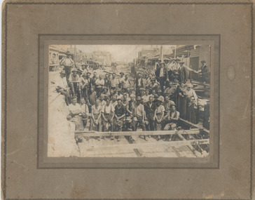
 City of Moorabbin Historical Society (Operating the Box Cottage Museum)
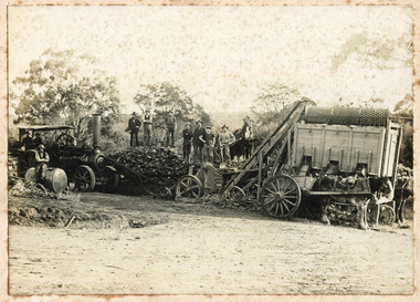
Photograph - Photograph, 1908 Excavation commences for the Melbourne Benevolent Society, Cheltenham, 1908 Excavation commences for the Melbourne Benevolent Society, Cheltenham, 1908
Excavating prior to the building of Melbourne Benevolent Society in Cheltenham. The Centre had begun life in 1850 in Melbourne, as the Victoria Benevolent Asylum to "relieve the aged, infirm, disabled and destitute poor of all creeds and nations and to minister to them the comfort of religion" It outgrew its North Melbourne premises so was located to a new site at Warrigal Road, Cheltenham. The foundation stone was laid in 1909, and the main buildings were completed in 1911. In 1970 the benevolent Asylum was re-named Kingston Centre. The photograph is black and white. It's a photo depicting the excavation prior to the building of Melbourne Benevolent Society in Cheltenham. The photograph shows eleven workers at the excavation site. There are two horses with carriages and a large excavating machine to the right of the photograph. benevolent asylum, benevolent society, cheltenham, train, machinery, men, society, horses, kingston centre -
 Phillip Island and District Historical Society Inc.
Photograph, John Cook, 1978 - 79
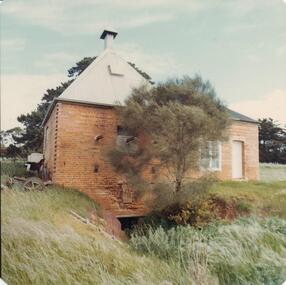
Old Chicory Kiln on Richardsons' Hill, Ventnor Beach Road, Ventor. Now used as a family home. The shed converted into extension of modern house.Brick Chicory Kiln with corrigated iron roof. Note the excavation beneath it for collecting the ashes.coloured photograph, chicory kiln, richardsons hill, john cook, ventnor, phillip island -
 Kew Historical Society Inc
Photograph - Road works in Studley Park Road, 1968
One of a series of photographs donated by the City Engineer of the former City of Kew, relating to road works and rubbish removal.One of a series of photographs of core local government services as practised by the City of Kew. The photographs are an accurate record of council works of the period.Original black and white photographic positive of excavations in the roadway of Studley Park Road in 1968."STUDLEY PARK ROAD AT CARSON STREET / 1968/9"city of kew, local government -- city of kew, council works, street maintenance -
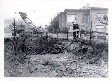
 City of Kingston
Photograph - Black and white, c. 1958
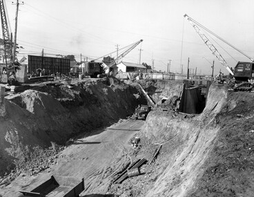
Moorabbin station sits on the Frankston line which first opened in 1882 when the line was extended from Mordialloc. Moorabbin station opened in 1881 and was originally called South Brighton station. It was renamed Moorabbin station in 1907. In 1958 the station was relocated below street level which coincided with other construction works on Nepean Highway and South Road. This image is part of a larger collection of images from the Public Transport Corporation displaying train stations and streetscapes in what is now the City of Kingston.Black and white photograph showing excavations for Moorabbin station to be moved below street level. Stamped in blue ink on reverse: COPYRIGHT / Public Transport Corporation / For re-ordering photographs / Please quote negative No M6004 / Enquiries C/- PTC Photographic Unit / Telephone switchboard 619 111moorabbin, railway station, construction works, suburbs, nepean highway -
 Bendigo Historical Society Inc.
Slide - DAVID MCDONALD COLLECTION: EPPALOCK. CONSTRUCTION, c1960
Eppalock. Construction. Slide show the construction of Lake Eppalock. Water tower constructed, excavation is in progress.Agfacolorcivil engineering, water supply, eppalock -
 City of Kingston
Photograph - Black and white, c. 1957
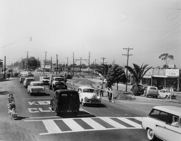
Copy black and white photograph of railway level crossing on Nepean Highway Moorabbin before excavations for the below ground rail crossing. The level crossing gates are closed and five cars are waiting, while other cars can be seen coming in the opposite direction. A woman with a child in a pram is walking along the road, and a number of men, probably construction workers, are standing behind a barricade on the right hand side of the road. Gilbey's Gin distillery is visible in the background. TCopy black and white photograph of railway level crossing on Nepean Highway Moorabbin before excavations for the below ground rail crossing. The level crossing gates are closed and five cars are waiting, while other cars can be seen coming in the opposite direction. A woman with a child in a pram is walking along the road, and a number of men, probably construction workers, are standing behind a barricade on the right hand side of the road. Gilbey's Gin distillery is visible in the background. Handwritten in blue ink on reverse: 57-465C Handwritten in red ink on reverse: 71% A red circle has been drawn around all handwritten text.moorabbin, railway station, railway crossing, suburbs, cars, local production -
Glenelg Shire Council Cultural Collection
Photograph - Photograph - Creek Diversion, Portland, n.d
Port of Portland Authority Archivesport of portland archives, creek diversion, botanical gardens, portland -
 Bendigo Historical Society Inc.
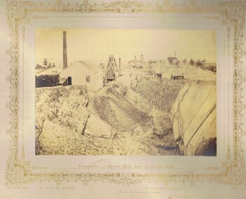
Photograph - VIEWS OF BENDIGO: EXCAVATION OF QUARTZ REEF NEAR IRONBARK HILL, c. 1870s
Sepia toned photograph. Photograph No. 7: Excavation of Quartz Reef near ironbark hill (two copies)N.J. Cairetopic, mining, battery -
 Port Melbourne Historical & Preservation Society
Photograph - Photograph (digitally restored), Workers in main drain excavation, Princes Street, Port Melbourne, Appro Images, 1933
Digitally restored print of 1933 photograph of construction workers in the excavation for the main drain in Princes Street (799.01).princes street, engineering - board of works, engineering - canals and drainage, business and traders - hotels, sydney 'gus' brown, built environment - domestic, built environment - commercial, swallow & ariell ltd -
 Kew Historical Society Inc
Photograph - Road works in the City of Kew, 1968-9
One of a series of photographs donated by the City Engineer of the former City of Kew, showing road works. The photos variably include council workers, signage and equipment.One of a series of photographs of core local government services as practised by the City of Kew. The photographs are an accurate record of street works of the period. Original black and white photographic positive of a road works in the former City of Kew. The photo shows an excavation in Studley Park Road near the corner of Carson Street in 1968/9. A Council officer and worker inspect the pit. Excavation equipment and a Council truck are at the back of the view. STUDLEY PARK ROAD AT CARSON STREET 1968/9city of kew, local government -- city of kew, road works, street works, kew city depot, studley park road -- kew (vic.) -
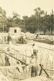
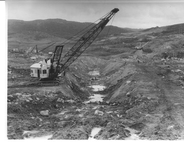 Kiewa Valley Historical Society
Photograph Rocky Valley Dam Excavations, Rocky Valley Dam Wall Excavation, c1947-48
Work commenced at Rocky Valley Dam site in early 1947 and proceeded until May. Resumed work in October after the winter and a camp for the accommodation of workmen was commenced at this time. Work continued in 1948 with the establishment of work facilities, including the erection of two large excavators. At the dam site the river was diverted through a temporary pipeline. Work proceeded in the summer months with the placing of concrete in the foundations and earth and rock fill for the construction of the wall. Rocky Valley and associated spillway and outlet works were completed in March, 1959. A very good representation of the type of machinery available in the 1940's used for excavation of the dam and the construction of the dam wall.Black and white photograph of Rocky Valley Dam wall under construction. There are at least three cranes plus workmen in the photo. This is taken from the Heathey's Spur side of the dam wall looking back toward Sun Valley.Hand written on back of photograph "Rocky Valley Dam Wall Excavation" in blue ink.rocky valley, dam, wall, machinery -
Whitehorse Historical Society Inc.
Book, Archaeological Excavation, 2000
An archaeological excavation of Mitcham Road Creek CrossingAn archaeological excavation of Mitcham Road Creek Crossing 9H7922-0229), Mitcham, Victoria. October 2000. Project no 1881.An archaeological excavation of Mitcham Road Creek Crossing archaeological sites, historic buildings, mitcham road, mitcham, roads and streets, vicroads -
Tatura Irrigation & Wartime Camps Museum
Photograph, Goulburn Waranga Main Channel Construction, 1957
Taken by photographer for State Rivers and Water Supply Commission.Large black and white photograph dry mounted on to cream board. Landscape scene depicting newly excavated ground with solitary man within scene.Below photograph: "GOULBURN WARANGA MAIN CHANNEL CONSTRUCTION / CHANNEL EXCAVATION AND BEACHING / LOOKING DOWNSTREAM" victoria state rivers and water supply commission, goulburn waranga main channel, goulburn, waranga -
Glenelg Shire Council Cultural Collection
Photograph - Photograph - Scene of foreshore development, 1950s
Port of Portland Authority archivesFront: (no inscriptions) Back: fd009 (pencil, upper left) P.G. 5. (blue pen, upper right)port of portland archives, bulldozer, excavation site, all saints, cliffs -
Glenelg Shire Council Cultural Collection
Slide - Slide - Cashmore Airport, Portland, 1980s
Coloured slide. Excavation site. Body of water on left. A retaining wall, formwork for concrete pour, right hand end of water.portland airport, cashmore airport, construction site, engineering