Showing 159 items matching " hustler's reef mine"
-
 Bendigo Historical Society Inc.
Map - STRUGNELL COLLECTION: HUSTLER'S LINE OF REEFS, BENDIGO, September 1913
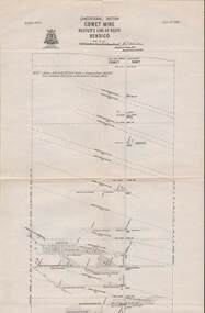
... Map, Hustler's Line of Reefs, Comet Mine, Longitudinal..., Hustler's Line of Reefs, Comet Mine, Longitudinal Section.Plate ...Map, Hustler's Line of Reefs, Comet Mine, Longitudinal Section.Plate No.XXV1 (26).Bulletin No 33 Signed H.A.Whitelaw Underground survey Office Bendigo September 1913 Drawing shows the vertical shaft descending to over 1692 feetUnderground Survey Office, Bendigo.map, bendigo, comet mine -
 Bendigo Historical Society Inc.
Map - STRUGNELL COLLECTION: HUSTLER'S LINE OF REEFS, BENDIGO
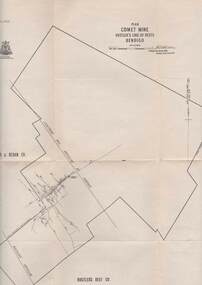
... Map, Hustler's Line of Reefs, Comet Mine, Plan, Plate... Underground Survey Office, Bendigo. Map, Hustler's Line of Reefs ...Map, Hustler's Line of Reefs, Comet Mine, Plan, Plate No. XX111 (23).Lightning Hill Anticline at Surface, United Hustler's & Redan Co., Hustler's Reef Co..Bulletin No 33 Signed H.A.Whitelaw Underground survey Office Bendigo September 1913Underground Survey Office, Bendigo. -
 Bendigo Historical Society Inc.
Map - STRUGNELL COLLECTION: HUSTLER'S LINE OF REEFS, BENDIGO, September 1913
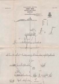
... Map, Hustler's Line of Reefs, Comet Mine, Transverse..., Hustler's Line of Reefs, Comet Mine, Transverse Section, Plate ...Map, Hustler's Line of Reefs, Comet Mine, Transverse Section, Plate No.XXV (25). Bulletin No 33 Signed H.A.Whitelaw. Drawing shows the vertical shaft descending to over 1692 feet and appears to show samples of connecting horizontal shafts with their respective mineral contentsUnderground Survey Office, Bendigo.map, bendigo, comet mine -
 Bendigo Historical Society Inc.
Map - STRUGNELL COLLECTION: HUSTLER'S LINE OF REEFS, BENDIGO, September 1913
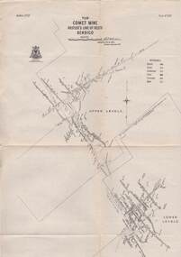
... Map, Hustler's Line of Reefs, Comet Mine, Bendigo..., Hustler's Line of Reefs, Comet Mine, Bendigo Plan.Plate No.XX1V (24 ...Map, Hustler's Line of Reefs, Comet Mine, Bendigo Plan.Plate No.XX1V (24). Map, Bulletin No 33 Signed H.A.Whitelaw Underground survey Office Bendigo September 1913 Drawing shows upper and lower levels and appears to show samples of connecting horizontal shafts with their respective mineral contentsUnderground Survey Office, Bendigo.map, bendigo, comet mine -
 Bendigo Historical Society Inc.
Map - STRUGNELL COLLECTION: HUSTLER'S LINE OF REEFS, BENDIGO, September 1913
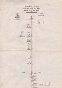
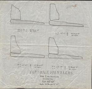
... Map, Hustler's Line of Reefs, Fortuna Hustler's Mine.... Map, Hustler's Line of Reefs, Fortuna Hustler's Mine, Bendigo ...Map, Hustler's Line of Reefs, Fortuna Hustler's Mine, Bendigo, Transverse Section. Plate Mo.111(3).Bulletin No 33 Signed H.A.Whitelaw. Drawing shows the vertical shaft descending to over 2228 feet and appears to show samples of connecting horizontal shafts with their respective mineral contentsUnderground Survey Office, Bendigo.map, bendigo, fortuna hustler's mine -
 Bendigo Historical Society Inc.
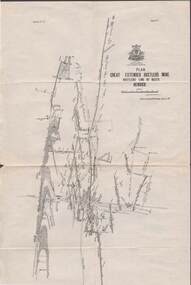
Map - HUSTLER'S REEF & HUSTLER'S REEF NO 1 MINES - PLAN OF THE HUSTLER'S REEF & HUSTLER'S REEF NO 1 MINES
... Plan of the Hustler's Reef & Hustler's Reef No 1 Mines... Mines Hustler's Line of Reefs H A Whitelaw Underground Survey ...Plan of the Hustler's Reef & Hustler's Reef No 1 Mines on the Hustler's Line of Reefs, Bendigo Bulletin No 33, Plate No XVI. Plan shows the two shafts and the levels in relation to it. No 9 Level 896 feet 9 inches connecting No 10 Level at 867 feet 2 inches. Plan shows depth of levels and geographical features. Signed by H A Whitelaw, Underground Survey Office, Bendigo. Geographical Survey of Victoria emblem.mining, parish map, hustler's reef & hustler's reef no 1 mines, hustler's line of reefs, h a whitelaw, underground survey office bendigo, geographical survey of victoria -
 Bendigo Historical Society Inc.
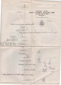
Document - Great Extended Hustler's mines, April, 2014
... Hustlers Tribute of Pups Shaft, Hustler's line of reef. Mine... Mine Hustler's Line of Reef Old Comet United Hustler's Redan ...Seven men were killed at the Great Extended Hustler's mine disaster on 2nd May 1914 by an explosion of dynamite occurring as the men were waiting at the plat to ascend the mine at the end of their shift. No blame was attached to anyone in the findings of the inquisition. It was unknown what caused the dynamite to explode. Three page typed document written by Albert Richardson. First page: Great Extended Hustler's including. Great Extended Hustlers Tribute of Pups Shaft, Hustler's line of reef. Mine formed in 1865, closed down 1925 or 1926. Locality, area of lease, depth of shaft, plant , early history, prominent and leading mines and best gold obtained from the mines is discussed. Poppet heads of the Great Extended Hustlers to the Stanfield mine at Long Gully and then to the Wattle Gully mine at Chewton.great extended hustlers, goldmining, accident, quartz, mining, k.k. mine, comet mine, hustler's line of reef, old comet, united hustler's, redan, poppet head, chewton, stanfield gold mine, wattle gully gold mine -
 Bendigo Historical Society Inc.
Map - HUSTLER'S REEF & HUSTLER'S REEF NO 1 MINES - LONGITUDINAL SECTION OF THE HUSTLER'S REEF & HUSTLER'S
... No 1 Mines on the Hustler's Line of Reef. Bulletin No 33... & Hustler's Reef No 1 Mines on the Hustler's Line of Reef. Bulletin ...Longitudinal Section of the Hustler's Reef & Hustler's Reef No 1 Mines on the Hustler's Line of Reef. Bulletin No 33, Plate No XX. Note - Plates 4, 8, 13, 20, 26 & 31 form a Longitudinal Section from Fortuna Hustler's to Hustler's Consols Mine. Geological Survey of Victoria emblem. Signed by H A Whitelaw, Underground Survey Office Bendigo, September 1913. Shows the two shafts with their levels and depths. Also shows geographical features and yields of gold and amalgam per ton. .mining, parish map, hustler's reef & hustler's reef no 1 mines, geographical survey of victoria, underground survey office bendigo, h a whitelaw -
 Bendigo Historical Society Inc.
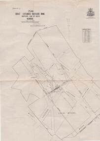
Map - HUSTLER'S REEF & HUSTLER'S REEF NO 1 MINES - PLAN OF THE HUSTLER'S REEF & HUSTLER'S REEF NO 1 MINES
... Plan of the Hustler's Reef & Hustler's Reef No 1 Mines... Reef & Hustler's Reef No 1 Mines on the Hustler's Line of Reefs ...Plan of the Hustler's Reef & Hustler's Reef No 1 Mines on the Hustler's Line of Reefs Bulletin No 33, Plate No XV. Plan shows the two mines with depth of levels, geological features and levels in relation to the shaft. Geological Survey of Victoria emblem and signed by H A Whitelaw, Underground Survey Office Bendigo, September 1913. Note - The Lease Boundaries shown on this plan are only in their approximate relative positions to Nos 13, Intermediate and 14 Levels of the Hustler's Reef No 1 workings, and Nos 15, 16 and 17 Levels of the Hustler's Reef workings.mining, parish map, hustler's reef & hustler's reef no 1 mines, geological survey of victoria, underground survey office bendigo, h a whitelaw, hustler's line of reefs -
 Bendigo Historical Society Inc.
Map - HUSTLER'S REEF & HUSTLER'S REEF NO 1 MINES - PLAN OF THE HUSTLER'S REEF & HUSTLER'S REEF NO 1 MINES
... Plan of the Hustler's Reef & Hustler's Reef No 1 Mines... Mines Hustler's Line of Reefs Lightning Hill Line of Reefs Comet ...Plan of the Hustler's Reef & Hustler's Reef No 1 Mines on the Hustler's Line of Reefs, Bendigo Bulletin No 33, Plate No XIV. No 8 connecting No 10 (Hustler's Reef), No 11 connecting No 13 (Hustler's Reef), No 13 (Hustler's Reef No 1) connecting No 15 (Hustler's Reef) and No 10 Hustler's Reef No 1 rise to Comet Mine. Map shows different levels in relation to the two shafts, the lines of the Hustler's Line of Reefs and the Lightning Hill Line of Reefs, the approximate Boundary of Lease and the Comet Co., the adjoining lease. Table on the left shows the levels and their depths of the two mines. Signed by H A Whitelaw, Underground Survey Office, Bendigo, September 1913. Geological Survey of Victoria emblem. mining, parish map, hustler's reef & hustler's reef no 1 mines, hustler's line of reefs lightning hill line of reefs, comet co., h a whitelaw, underground survey office bendigo, geological survey of victoria -
 Bendigo Historical Society Inc.
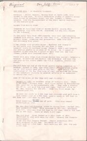
Document - Regulation of Mines Bill, famous mines of Bendigo, April, 2014
... . Hustler's Line of Reef mines are listed from north to south: Hustler... Mine Hustler's Line of Reef Old Comet United Hustler's Redan ...Seven men were killed at the Great Extended Hustler's mine disaster on 2nd May 1914 by an explosion of dynamite occurring as the men were waiting at the plat to ascend the mine at the end of their shift. No blame was attached to anyone in the findings of the inquisition. It was unknown what caused the dynamite to explode. Three page typed document. First page: 'The Regulation of Mines Bill' by Albert Richardson; Angus Mackay, Minister of Mines introduced the Bill in the Legislative Assembly on October 16th 1873 and it became law on January 1st 1874. Second page: 'Famous Gold Mines of Bendigo and Eaglehawk' by Albert Richardson, discusses deep shafts, more than 4000 feet shafts, wages for 1911. Hustler's Line of Reef mines are listed from north to south: Hustler Consols; United Hustler's and Redan, K.K., Comet, Hustler's Reef No. 1, Hustlers Reef, Great Extended Hustlers (formed 4.2.1865) Hustler's Royal Reserve Co., (Park Shaft) Hustler's Royal Reserve (City Shaft) and Fortuna Hustler's (formed August 1888).great extended hustlers, goldmining, accident, quartz, mining, k.k. mine, comet mine, hustler's line of reef, old comet, united hustler's, redan -
Bendigo Historical Society Inc.
Document - MINING IN BENDIGO COLLECTION: NOTES ON MINING IN BENDIGO
Handwritten notes on mining in Bendigo. Notes mention the size of the Bendigo Goldfield, the number of lines of reef and a brief history of goldmining in Bendigo.document, gold, mining in bendigo, mining in bendigo, notes on mining in bendigo, ravenswood sheep run, survey regiment, california hill state school, lansell's 222, mr lansell, camp hill school, high school, park mine (royal hustler's reserve no 1), memorial hall, city mine ( royal hustlers reserve no 2), mining stock exchange, beehive buildings, allan's walk, buckell & jeffrey, fortuna hustlers, great extended huatlers, garden gully united, mining exchange, garden gully united, wattle gully mine, ironbark mine, manchester arms hotel, extended hustlers mine, south belle vue, new chum railway, eureka extended, shenandoah, victoria quartz, the big 180, old chum, gt extended hustlers -
Bendigo Historical Society Inc.
Document - MINING IN BENDIGO COLLECTION: NOTES ON MINES
Handwritten notes on Bendigo Mines. Notes include the number of ounces of gold obtained up to 1954 when the mines closed, total dividends paid, average production per ton, number of shafts The Mines Dept, made safe, notes on the South New Moon, Garden Gully United, New Chum Goldfields and the Catherine Reef United.document, gold, mining in bendigo, mining in bendigo, notes on mines, carlisle, central blue, central nell gwynne, fortuna hustlers, garden gully united, lady barkly, new argus, new red white & blue consol, south new moon, mines dep't, garden gully united, healthy golden bendigo, south new moon, roberts & sons, new chum goldfields, catherine reef united -
Bendigo Historical Society Inc.
Book - DEPARTMENT OF MINES 1914 BULLETINS OF THE GEOLOGICAL SURVEY OF VICTORIA NO. 33. HUSTLER'S LINE OF REEF, BENDIGO, 1914
... . Photos of the mines on the Hustler's Line of Reef. 59 pages plus ...Department of Mines 1914 Bulletins of the Geological Survey of Victoria No. 33. Hustler's Line of Reef, Bendigo. Photos of the mines on the Hustler's Line of Reef. 59 pages plus 7 pages of photos. Inscribed A. Richardson 29 Harrison street, BendigoDepartment of Mines.bendigo, mining, hustler's line of reef, mining, and hustler's reef mines. -
 Bendigo Historical Society Inc.
Document - NEW CHUM, VICTORIA AND HUSTLERS HILL AND REEF LINES
Five page typed document. On top in handwriting ' Original, for self tour'. New Chum Hill is situated in Golden Square, Marong Road on north side, Lilly Street to the east, Chum Street on souther slope and Lansell's Fortuna on the wesern side. Mines on the hill are listed: Lansell's 180, The New Chum and Victoria, the Old Chum, the Lazarus, the New Chum United, the New Chum Consolidated and the Garibaldi. The Mungo group of mines on the New Chum Line of Reef at Eaglehawk are listed: Ellenborough, St. Mungo, Lady Barkly and South Sth Mungo. Victoria Hill mines: Rae's, Wittscheibe and Co., Lansell's 180.Albert Richardson -
 Bendigo Historical Society Inc.
Document - ALBERT RICHARDSON COLLECTION: SECRETARY FOR MINES ANNUAL REPORT 1911
Three page typed report titled ' Notes on diagram showing pitch lines, Bendigo'. Longitudinal sections along the lines of reefs or anticlines within the 8 mile block at Bendigo are shown in a diagram' (diagram not included with notes) Mines and reef lines mentioned in the report are : New Chum line, New Chum Railway mine, Catherine United mine, Hercules and Energetic mine, Garden Gully, Hustlers and Redan, Sheepshead Reef, Sea Mine, Garden Gully, Miller's line of reef and Bendigo Development Mine. The 'old stacks' or chimneys, on Bendigo are described. 'Among the earliest of the stacks built at Bendigo in connexion with Quartz crushing plant, are the two figured in this Annual report No 1 was situate in Sailor's Gully but was demolished about three years ago. This, if not the first, must have been one of the first built, for it had a stone inserted on which chiselled the date 1854. It was built altogether of rough masonry. The other, No. 2, is still standing at the Sheepshead line and was apparently of later date, the upper portion being of brick. They are intersting landmarks of an era that is rapidly passing.' Map attached to report showing location of stacks. Stack at Sailors Gully was near the corner of Murchison Street and Lester Street. The stack at Sheepshead ( Deborah Triangle area) was near the intersection of Belle Vue Road and Adam Street.bendigo, mining, pitch lines bendigo -
 Bendigo Historical Society Inc.
Document - ALBERT RICHARDSON COLLECTION DEEP MINES ON THE BENDIGO FIELD
One page document titled ' Secretary for Mine's Report for 1911, Deep Mines page 24. List of mines and depths, The Victoria Quartz 4614 feet, New Chum Railway 4318 feet, Lazarus New Chum 3682 feet, New Chum and Victoria 3579 feet, North Johnson's 3498 feet, Carlisle 3460 feet, Lansell's 180 3365 feet, Clarence 3310 feet, Great Extended Hustlers 3290 feet, Ironbark 3250 feet, Victoria Consols 3114 feet, New Chum Consolidated 3099 feet, Eureka Extended3060 feet, Princess Dagmar 3020 feet, Johnsons Reef No 2 2020 feet.bendigo, mining, deep mines on the field -
Bendigo Historical Society Inc.
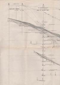
Map - HUSTLER'S & CHRISTMAS LINES OF REEFS - PLAN OF LINES OF SECTION OF REEFS
Underground Survey of Mines Bendigo. Plan of Cross Section Lines Shewing Connections with Trigonometrical Stations and Base Lines. 13/3/99 Signed ? Stirling. Places and mines mentioned Speciman Hill, Tambour Major, Lansell's 180, Victory and Pandora, Great Extended Hustler's, Windmill Hill on Victoria Reef. Next part of map is a Plan of Lines of Section between the Hustler's and Christmas Lines of Reefs. 8/3/99. Signed ?. Transverse Section. Shows Tambour Major Co., near the Christmas Line of Reef, Crosscuts and their depth, geological features and stone encountered. Then shows Thistle Line, Charshalton Line, Napoleon Line, Nell Gwynne Line, New Chum Line, Lansell's No 180 with levels, depths and geological features. Drawing is continued in three parts to fit on paper. Lansell's East Shaft with levels and depths, geological features and stone encountered. Sheepshead Line, Old Shaft, Garden Gully Line, Victory and Pabndora Co with crosscuts, depths, geological features and stone encountered. Paddy's Gully Line, Derby Line, Millers Line, Hustler's Line, Great Extended Hustler's Co with levels, depths, geological features and stone encountered. A note beside a Saddle Reef: 360,000 pounds paid in dividends from this reef. Average ounces per ton gold noted where found. Reference Table for stone and geological features. Datum Line 700 feet above Sea Level Unscannedmining, parish map, hustler's & christmas lines of reefs, plan of lines of section of reefs, ? stirling, specimen hill, tambour major, lansell's 180, victory & pandora, great extended hustler's, windmill hill, victoria reef, tambour major co, christmas line, hustler's line, thistle line, carshalton line, napoleon line, nell gwynne line, new chum line, lansell's no 180, lansell's east shaft, sheepshead line, old shaft, garden gully line, paddy's gully line, derby line, miller's line, hustler's line, great extended hustler's co -
 Bendigo Historical Society Inc.
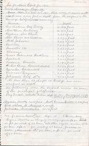
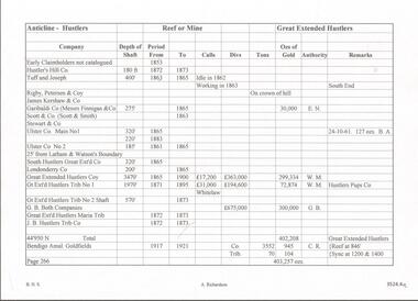
Document - GREAT EXTENDED HUSTLERS MINE - NOTES ON HUSTLERS ANTICLINE
Two copies of two pages of hand written notes (one in blue pen and one in black pen) on the Hustlers Anticline. They are numbered Page 266 (Great Extended Hustlers) and Page 267 (Latham and Watsons). Notes give name of company, depth of shaft, the years, Calls, Divs, Tons, Ozs of Gold, Authority and Remarks. Black copy has: Copied 25-10-68 written on it.mine, gold, great extended hustlers., great extended hustlers mine, hustlers anticline, hustlers hill co., tuff & joseph, rigby peterson & co, james kershaw & co, garibaldi co, messrs finnigan & co, scott & smith, stewart & co, ulster coy main no 1& no 2, south hustlers great extd co, londonderry co, great extended hustlers, great extended hustlers trib no 1, g. b. both co, great extended hustlers maria trib, j b hustlers trib co, bendigo amal goldfields, jonathan harris claim (hustlers or mac's hill), latham watson & hustlers, latham watson & sibley (sibley & co), latham & watson, latham & watson's nos 1 & 2 tribs, great hustlers co, great extended hustlers reef g m no 1, koh-i-noon co -
 Bendigo Historical Society Inc.
Document - FORTUNA COLLECTION: FORTUNA HUSTLERS - NOTES ON THE FORTUNA HUSTLERS
Four copies, 1 hand written and 3 typed copies of notes on the Fortuna Hustlers Mine. Notes include depth of shaft, size of lease, locality, plant, other mines where the winding engine worked, prominence, best reefs, total production. References: Mines Dept Special Edition 'Australian Mining Standard' 1/6/1899; Mines Dept Booklet 'Bendigo Goldfield' Geo Brown 1936; Mines Dept Booklet No 33 H. Herman 1914; 'Annals of Bendigo' (Mining Sections, From 1888 - 1913): A. Richardson.mine, gold, fortuna hustlers, fortuna hustlers, hustlers line of reef, railway goods sheds, buckell & jeffrey's, roberts & sons, tambour major, birds reef, hercules no 1, north virginia mine, gold production & dividends, australian mining standard (special edition) 1/6/1899, mines dept booklet 'bendigo goldfields' 1936, mines dept bulletin no 33, h herman 1914, annals of bendigo mining section 1888 - 1913, a richardson -
 Bendigo Historical Society Inc.
Document - CENTRAL RED, WHITE AND BLUE MINE - NOTES ON THE CENTRAL RED, WHITE AND BLUE MINE
Seven pages of hand written notes on the Central Red, White and Blue Mine. Information on how the mine was obtained and geological information. Initialled AR.mine, gold, central red, white and blue mine, central red, white and blue mine, notes on the central red, white and blue mine, lansell's little 180, eadie's, sheepshead reef, mr g w lansell, central blue, cr t c pryor, delbridge (manning's) shaft, garden gully line, hustlers line, ar -
 Bendigo Historical Society Inc.
Map - STRUGNELL COLLECTION: HUSTLER'S LINE OF REEFS, BENDIGO, September 1913
... Map, Hustler's Line of Reefs, Great Extended Hustler's Mine... Bendigo great extended hustler's mine Underground Survey Office ...Map, Hustler's Line of Reefs, Great Extended Hustler's Mine, Bendigo, Transverse Section. Plate No. X11 (12). Bulletin No 33 Signed H.A.Whitelaw Underground survey Office Bendigo September 1913 Drawing shows mine shaft to over 3454 feet deep and appears to show samples of connecting horizontal shafts with their respective mineral contentsUnderground Survey Office, Bendigo.map, bendigo, great extended hustler's mine -
 Bendigo Historical Society Inc.
Map - STRUGNELL COLLECTION: HUSTLER'S LINE OF REEFS, BENDIGO, September 1913
... Map, Hustler's Line of Reefs, Great Extended Hustler's Mine... Bendigo great extended hustler's mine Underground Survey Office ...Map, Hustler's Line of Reefs, Great Extended Hustler's Mine, Longitudinal Section Plate No X111 (13). Bulletin No 33 Signed H.A.Whitelaw Underground survey Office Bendigo September 1913 Drawing shows mine shaft to over 3454 feet deep and appears to show samples of connecting horizontal shaftsUnderground Survey Office, Bendigo.map, bendigo, great extended hustler's mine -
 Bendigo Historical Society Inc.
Map - STRUGNELL COLLECTION: HUSTLER'S LINE OF REEFS, BENDIGO, September 1913
... Map, Hustler's Line of Reefs, Great Extended Hustler's Mine... Bendigo great extended hustler's mine Underground Survey Office ...Map, Hustler's Line of Reefs, Great Extended Hustler's Mine Plan, Plate No. X1 (11). Bulletin No 33 Signed H.A.Whitelaw Underground survey Office Bendigo September 1913.Underground Survey Office, Bendigo.map, bendigo, great extended hustler's mine -
 Bendigo Historical Society Inc.
Map - STRUGNELL COLLECTION: HUSTLER'S LINE OF REEFS, BENDIGO, September 1913
... Map, Hustler's Line of Reefs, Great Extended Hustler's Mine... Bendigo great extended hustler's mine Underground Survey Office ...Map, Hustler's Line of Reefs, Great Extended Hustler's Mine Plan,Plate No X (10).Bulletin No 33 Signed H.A.Whitelaw Underground survey Office Bendigo September 1913 Drawing has a table showing depths of levelsUnderground Survey Office, Bendigo.map, bendigo, great extended hustler's mine -
 Bendigo Historical Society Inc.
Map - STRUGNELL COLLECTION: HUSTLER'S LINE OF REEF, BENDIGO, September 1913
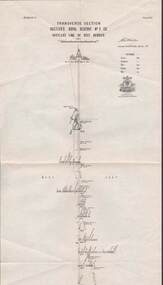
Map, Hustler's Line of Reef, Hustler's Royal Reserve No. 2 Co, Bendigo,Transverse Section, Plate No.V11 (7). Bulletin No 33 Signed H.A.Whitelaw Underground survey Office Bendigo September 1913 Drawing shows mine shaft to over 1640 feet deep and appears to show samples of connecting horizontal shafts with their respective mineral contentsUnderground Survey Office, Bendigo.map, bendigo, hustler's royal reserve no. 2 mine* -
 Bendigo Historical Society Inc.
Map - STRUGNELL COLLECTION: HUSTLER'S LINE OF REEFS, BENDIGO, September 1913
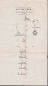
Map, Hustler's Line of Reef, Hustler's Royal Reserve No. 2, Park Shaft, Bendigo, Plate No. 1X (9). Bulletin No 33 Signed H.A.Whitelaw Underground survey Office Bendigo September 1913 Drawing shows mine shaft to over 1099 feet deep and appears to show samples of connecting horizontal shafts with their respective mineral contentsUnderground Survey Office, Bendigo.map, bendigo, hustler's royal reserve no. 2 mine* -
 Bendigo Historical Society Inc.
Map - STRUGNELL COLLECTION: HUSTLER'S LINE OF REEFS, BENDIGO, September 1913
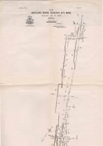
Map, Hustler's Line of Reefs, Hustler's Royal Reserve No. 2 Mine, Bendigo.Plate No. V (5).. Great Extended Hustler's Lease, Imperial Hustler's, Hustler's Royal Reserve No. 2 Park & Main Shafts, Fortuna Hustler's Lease.Bulletin No 33 Signed H.A.Whitelaw Underground survey Office Bendigo September 1913Underground Survey Office, Bendigo.map, bendigo, hustler's royal reserve no. 2 mine* -
 Bendigo Historical Society Inc.
Map - STRUGNELL COLLECTION: HUSTLER'S LINE OF REEFS, BENDIGO, September 1913
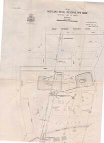
Map, Hustler's Line of Reefs, Hustler's Royal Reserve No.2 Mine, Bendigo Plan. Plate No.V1 (6). Bulletin No 33 Signed H.A.Whitelaw Underground survey Office Bendigo September 1913Underground Survey Office, Bendigo.map, bendigo, hustler's royal reserve no. 2 mine* -
 Bendigo Historical Society Inc.
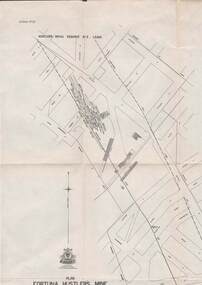
Map - STRUGNELL COLLECTION: HUSTLER'S LINE OF REEFS, BENDIGO, September 1913
... Map, Hustler's Line of Reefs, Bendigo, Plan Fortuna... Bendigo fortuna hustler's mine Underground Survey Office, Bendigo ...Map, Hustler's Line of Reefs, Bendigo, Plan Fortuna Hustler's Mine, Hustler's Royal Reserve No. 2 Lease. Plate No.1(1) Bulletin No 33 Signed H.A.Whitelaw.Underground Survey Office, Bendigo.map, bendigo, fortuna hustler's mine