Showing 134 items
matching index of plans
-
 Federation University Historical Collection
Book, Journal pertaining to BORES Berry Mines
... in black ink. Plans of shafts throughout 182 pages.Map/plan loose... throughout 182 pages.Map/plan loose at page 48. Index on pages 176 ...This book is associated with former Ballarat School of Mines Student Richard Squire (1875-1876). Gift of the Squire FamilyGreen water marked linen covered journal with maroon spine with red feint lined blue pages. Label on front cover is cream with black printing JOURNAL with handwritten BORES. Hand written in black ink. Plans of shafts throughout 182 pages.Map/plan loose at page 48. Index on pages 176 - 181Bores written on front cover berry consols, bores, gold, gold mining, mining, shafts, g. maryhans, charlesons, davies, coopers, west berry consols gold mining company -
Federation University Historical Collection
Notebook, Work Programme 1967, 1967
This is a syllabus programme prepared for the education of students by a teacher for the year 1967, along with his comments regarding the itinerary for each week's classes. The first section is divided into the schedule for each term of the school year. They are "Term 1", "Term 2", "Term 3" and "Term 4". These terms are further divided into columns with the headings "Grade 1'", "Grade 2", "Grade 4", "Grade 5", and "Grade 6".The Rows are titled "Speech", "Reading", "English", "Poetry", "Spelling & Dictation", "Writing", "Maths", "Social Studies", "Nature", "Creative Activities", "Music", and "Health & Phys. Ed". along with comments regarding the events of the week's classes. What follows is the class plan for each grade level with an index detailing each aspect of that grades education for the 1967 school year. They are "Infant Syllabus Grades 1 & 2" with the sections "Reading", "Word Study", "Number", "Spoken Expression", "Written Expression", "Writing", "Social Studies", "Nature Study", "Health", "Physical Education", "Literature", "Creative Activities", "Music", and "Character Training". The "Primary Syllabus Grades 4, 5 & 6" features the section "Mathematics", "Grammar", "Reading", "Oral Expression", "Written Expression", "Spelling", "Speech", "Poetry", "Social Studies", "Health", "Physical Education", "Music", "Creative Activities", and "Nature Study". A inset has been included within the notebook titled "Psychological Research Group:Grade VI. Grouped Spelling List." which was kept in a homemade paper pocket.Included throughout the notebook are various images taken from various sources, cut out and stuck to the front page of each section. The registration no. "11932" is included on the front page in pencil.alex ball, 1967, work programme, syllabus, grade 1, grade 2, grade 4, grade 5, grade 6, mathematics, grammar, reading, oral expression, written expression, spelling, speech, poetry, social studies, health, physical education, music, creative activities, nature study, notebook, english, spelling & dictation, writing, nature, health & phys. ed -
 City of Moorabbin Historical Society (Operating the Box Cottage Museum)
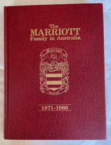
Book - Family History, Marriott, Ralph, The Marriott family in Australia, 1871-1986, 1986
... 371 p. : ill., facsims., geneal. tables, maps, plans, ports.... tables, maps, plans, ports.: includes index The Marriott family ...The History and family tree of John Marriott and his wife Emma Kitchen and their descendants in Australia, 1871-1986371 p. : ill., facsims., geneal. tables, maps, plans, ports.: includes indexnon-fictionThe History and family tree of John Marriott and his wife Emma Kitchen and their descendants in Australia, 1871-1986marriott, family history, market gardening, moorabbin, bentleigh, pioneer -
 City of Moorabbin Historical Society (Operating the Box Cottage Museum)
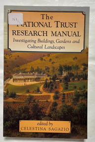
Book, Sagazio, Celestina, The National Trust research manual : investigating buildings, gardens and cultural landscapes, 1992
... xiv, 177 p. : ill., plans :Includes index. Bibliography: p... buildings historic gardens historic sites xiv, 177 p. : ill., plans ...xiv, 177 p. : ill., plans :Includes index. Bibliography: p. 147-168.non-fictionhistoric buildings, historic gardens, historic sites -
 City of Moorabbin Historical Society (Operating the Box Cottage Museum)
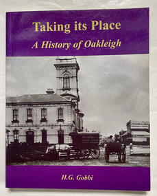
Book, Gobbi, H. G. (Helen Grace), Taking its place : a history of Oakleigh marking its sesquicentenary, 1853-2003, 2004
... 243 p. : ill., maps, plans; Includes index. Bibliography: p... history 243 p. : ill., maps, plans; Includes index. Bibliography ...243 p. : ill., maps, plans; Includes index. Bibliography: p. 232-235.oakleigh, history -
 Bendigo Historical Society Inc.
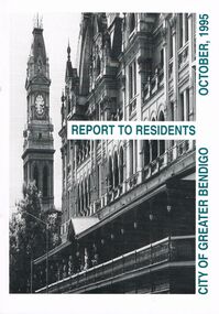
Book - BOOKLET: ''REPORT TO RESIDENTS CITY OF GREATER BENDIGO, OCTOBER 1995''
Front cover is a photo of The Shamrock Hotel. 52 paged booklet - ''Report to Residents - City of Greater Bendigo, October 1995''. Table of Contents; Commissioners; Chief Executive Officer; Council meetings; Office location and hours; ''One Telephone Number''; Committees; Ward boundaries; Elections; Customer services; Rural services; Economic development; Bendigo Tourism Board; Bendigo Trust; Events Bendigo; Capital works 1995/96; Major projects; Discovery; Bendigo Regional Arts Centre; local laws; Fire prevention; Aged and disability services; Children and family services; Environmental health; Recreation and leisure; Parks and gardens; Planning and building; Waste management; Library services; Bendigo Leisureland; Rates; Budget for 1995/96; Index. Contains some photographs and map of proposed 7 internal Wards for the City of Greater Bendigo.Richard Cambridge Printers Bendigo.bendigo, council, report, maxine crouch, maurie sharkey, perer ross-edwards, peter seamer, hadley sides, richard morriss, bernard smith, annie galvin child care centre, bendigo regional art centre, rosalind park, budget 1995/96. bendigo health care services. -
Bendigo Historical Society Inc.
Document - BUSH COLLECTION: LAND TRANSACTION LEDGER, 1880 - 1920
Handwritten ledger (alphabetized) of land transactions of Albert Bush, with numerous loose handwritten notes throughout. Plans are at the back (inside cover) of the book. One plan attached on inside front cover. Pages are arranged with information in columns - 1. Name, 2. Nature and particulars of security, 3. Situation and extent, 4. Amount and when payable, 5. Interest (paid and now payable), 6. Remarks. This ledger would be most informative with further research and indexing. 23/01/2020 Item missing AVperson, individual, bush collection - personal -
 Bendigo Historical Society Inc.
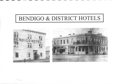
Document - INDEXES
Indexes Includes Names from the 1856 Petition Bendigo and District Hotels Final Marunari List Terry Davidson 1871 - 2018 Index to RHSV Bendigo Branch Newsletters Nov. 1971 - July 2002 Helen Mainka 1954 Bendigo Business District Directory McConnell’s Street and general Directory Date unknown Victorian Directory 1904 Bendigo and District Directory 1904 – 1905 Bendigo district general Directory 1859 City of Bendigo Historical Information Bendigo Hotels compiled by Len Bennetts Hotels of Bendigo and District Compiled by Len Bennetts Sandhurst Land Sales 1854 – 1856 Ralph Birrell Chronicles of Bendigo from the Bendigo Advertiser Christmas Supplement December 22 1904 Some Photographers 1850 – 1900. Including some Bendigo Photographers 1854 – 1958 St. Patrick’s Annual Sports advertisers. Date Unknown Fatalities listed in bendigo Advertiser 1888-1935. Two copies One by year. One alphabetical. District statistics - Mayors and Shire Presidents, Bendigo Football League Premiers 1880- 1987, Sportstar of the year 1965-1987 Plans of townships and Parishes held at Ducley House. From the Bendigo Lands Office 1976. -
Bendigo Historical Society Inc.
Book - THE AUSTRALIAN BOY SCOUT DIARY 1933, 1933
The Australian Boy Scout Diary 1933. Inside front cover is an intimate picture of Chief & his family. With specially written notes and Sketches for Cubs, Scouts, Rovers and Scouters. Obtainable at all State Headquaters in Australia. Prepared and Published by the Victorian Section in conjuntion with the Federal Scout Council of Australia. Printed by Exchange Press Pty Ltd, 310 Spencer Street, Melbourne. Index: Boy Scouts. Bush Fires. Calendars 1933, 1934. 1934 Calendar. Conventional Signs and Maps. Fires. First Aid. Headquaters Address. Holidays. Knots, Bends and Hitches. List of Badges. Local Fixtures. Morse. Our Flag. Personal Memoranda. Pioneering. Plan of Camp. Rover Scouts. Scout Uniform. Scout Signs and Salutes. Sea Scouts. Sea Scouting - Notes on Boat Handling. Semaphore. South by the Stars. Swimming. Torch. Treatment of Snakebite. Troop Camps. Weights and Measures. Wolf Cubs. Wood Badge. Uses of Scout Staff. Inside rear cover is a sepia photo of the site of the 1933 Jamboree at Godollo, Hungary. Book is very detailed giving information on all aspects of Scout life, with sketches for knots, maps, etc. Inscriptions are on page 58: Troup or Pack - 1st Epsom Pack. Watch No. 4133033. Season Ticket No. Commonwealth acc 957. Savings No. 4729. Size in Hats: 7. Size of Boots: 5. Size of Collar 14 1/2. Size of Gloves 6 1/4. Iinscription on page 60: Books Read: In Search of Wales, Morton. Faraway, Priestly. Jock the Scot, Alice Grant Rosemary. Bernard Shaw, Frank Harris.Exchange Press Pty Ltd., Melbournebook, bendigo, scouts, the australian boy scout diary 1933. photo of chief & his family. notes and sketches for cubs, scouts, rovers and scouters. obtainable at all state headquarters in australia. published by the victorian section in conjunction with the federal scout council of australia. exchange press pty ltd, melbourne. index: boy scouts. bush fires. calendars 1933, 1934. 1934 calendar. conventional signs and maps. fires. first aid. headquarters address. holidays. knots, bends and hitches. list of badges. local fixtures. morse. our flag. personal memoranda. pioneering. plan of camp. rover scouts. scout uniform. scout signs and salutes. sea scouts. sea scouting - notes on boat handling. semaphore. south by the stars. swimming. torch. treatment of snakebite. troop camps. weights and measures. wolf cubs. wood badge. uses of scout staff. sepia photo of the site of the 1933 jamboree at godollo, hungary. information on all aspects of scout life, with sketches for knots, maps, etc. inscriptions page 58: troup or pack - 1st epsom pack. watch no. 4133033. season ticket no. commonwealth acc 957. savings no. 4729. size in hats: 7. size of boots: 5. size of collar 14 1/2. size of gloves 6 1/4. page 60: books read: in search of wales, morton. faraway, priestly. jock the scot, alice grant rosemary. bernard shaw, frank harris. -
 Bendigo Historical Society Inc.
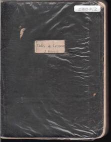
Book - HARRIS COLLECTION: NOTES OF LESSONS: J HARRIS
Hard black cardboard covered Exercise book entitled : ''Notes of Lessons - J Harris'' Handwritten teacher's lesson plans 1929 with mention of two schools - Lee Street and Rathdowne Street. Has Index of Lessons at front of book.person, individual, j. harris, lee street, rathdowne street. -
Port Melbourne Historical & Preservation Society
Album - Boxed Album, Bayside Development, 1985 - 1999
One of three boxed albums containing clippings related to "Bayside" Development 1983 and on, collected by Janet Bolitho and Greg Byrne, indexed by Jill Dawson 2014. Index on paper and disk at 2939.18Notations of publication/date on individual itemstown planning - proposals shelved - bayside, public action campaigns, local government - city of port melbourne, janet bolitho, sandridge city development co ltd, scdc, beacon cove, mirvac -
Port Melbourne Historical & Preservation Society
Archive - CD-ROM, Sandridge City Development Corporation development
A CD index of everything to do with the Sandridge City Development Corporation (SCDC - Beacon Cove -Mirvac) as noted in other 2939 catalogue numbers .town planning - proposals shelved - bayside, built environment, local government - city of port melbourne, public action campaigns, bayside development action group, bayside working group, scdc, beacon cove, mirvac, beris campbell, sandridge city development company pty ltd -
Port Melbourne Historical & Preservation Society
Plan - Montague Housing Development
... including index, copies (some laminated) Plan Montague Housing ...COPYRIGHT PUBLIC RECORDS OFFICE Set of plans and documents relating to the State Savings bank, Montague Housing Development, in Gladstone St, Montague. This was an initiative of South Melbourne City Council to replace slum housing in Montague, 1935-40 .02 - 41 A4 pages including index, copies (some laminated)built environment - domestic, state savings bank of victoria -
Port Melbourne Historical & Preservation Society
Archive - Bayside Development, Resident Action Group, Pat Grainger Archive, 1987 - 1992
These papers document Pat Grainger's involvement with the many facets of campaigning against the Sandridge City Development Company Bayside Project. Files & indexed by J Bolitho.Pat Grainger Archive - Bayside Development, Resident Action Group - Public Action Campaigner. Archival box containing audio tape & tape log. Individual manilla folders for the following years & subjects; 1987, Organisational submissions to ESS Sept 1987-Feb 1988, personal file retained from ESS Sept 1987 - Feb 1988. 1988, Friends of the Park 1988 - 1999. 1989 - 1994, Clarendon Street Bridge Light Raillink Advisory Committee.public action campaigns, local government - city of port melbourne, town planning - proposals shelved - bayside, melbourne harbor trust - port of melbourne authority, pat grainger -
Port Melbourne Historical & Preservation Society
Archive - Bayside Development, Resident Action Group, Lyn Allison Archive, 1992 - 1994
These papers document Lyn Allison's involvement in the above. Filed & indexed by J Bolitho.Covers Lyn Allison's background and these files record her involvement with the Bayside Development Action Group, the Bayside Open Planning Forum and the Bayside Working Group. Please note this is not a comprehensive collection of Lyn Allison's papers.public action campaigns, local government - city of port melbourne, town planning - proposals shelved - bayside, melbourne harbor trust - port of melbourne authority, lyn allison, bayside development action group, mark birrell, building heights, john drury, joan kirner, medium density housing, robert peck, chris raeburn, david rayson, dimity reed, wayne sanderson, jon shields, south port community legal service, urban consolidation, mayors -
Port Melbourne Historical & Preservation Society
Archive - BayLinks, Ian McKAY Archive, 1985 - 1992
These papers document Ian McKAY's involvement in the above. Filed & indexed by J BOLITHO.Ian McKAY key documents and themes - BayLinks, concept plan for Port Phillip Boulevard, info sheet from Swallow & Bain Street Residents Association, material about ESS, Port Melbourne Citizens Action Group, a response to the Bayside Development project, National Trust submissions (1985-92).public action campaigns, local government - city of port melbourne, town planning - proposals shelved - bayside, melbourne harbor trust - port of melbourne authority, ian mckay, janet bolitho -
 Port Melbourne Historical & Preservation Society
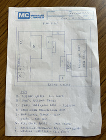
Document, MM Crane Factory - Plan View, 18 Feb 2020
Blue printed plan view of Malcolm Moore Crane Factory with lettered index of areas within the factory from 1979 some with names listed including Norm (presumably Norm Robinson).built environment - industrial, industry, engineering, malcolm moore pty ltd, norm robinson -
Port Melbourne Historical & Preservation Society
Album - Album, Building works at J Kitchen & Sons Pty Ltd, Port Melbourne, Ritter-Jeppesen Studios, 1953 - 1954
... on the back and on the page opposite, sometimes with a building plan... on the back and on the page opposite, sometimes with a building plan ....01 Brown imitation leather photograph album recording building at J KItchen & Sons from 13.01.1953 to 06.09.1954 (approx 100 pages) in black and white photos. Photos are labelled on the back and on the page opposite, sometimes with a building plan as well. .02 - Handwritten index of photos completed by PMHPS member Phil King 14.05.2013industry, manufacturing, built environment - industrial, j kitchen & sons pty ltd -
 Bendigo Historical Society Inc.
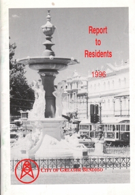
Book - BOOKLET: REPORT TO RESIDENTS CITY OF GREATER BENDIGO, 1996
Front cover is a photo of Alexandra Fountain. 52 paged booklet - ''Report to Residents - City of Greater Bendigo, 1995. Table of Contents; The Mayor; Chief Executive Officer; Council meetings; Office location and hours; ''One Telephone Number''; Locations of functions and business; Units; Organisation Structure; Advisory Committee; Municipal Boundaries; Customer services; Economic development; Bendigo Tourism; Bendigo Trust; Events Bendigo; Capital works 1996/97; Bendigo Regional Arts Centre; Local laws; Aged and disability services; Children and family services; Environmental health; Recreation and leisure; Parks and gardens; Planning and building; Waste management in Bendigo; Library services; Rates; Budget for 1996/97; The budget at a glance; Index.bendigo, council, report -
 Monbulk RSL Sub Branch
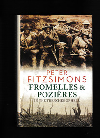
Book, Peter Fitzsimons, Fromelles and Pozières : in the trenches of hell, 2015
In the Trenches of Hell On 19 July 1916, 7000 Australian soldiers - in the first major action of the AIF on the Western Front - attacked entrenched German positions at Fromelles in northern France. By the next day, there were over 5500 casualties, including nearly 2000 dead - a bloodbath that the Australian War Memorial describes as 'the worst 24 hours in Australia's entire history. Just days later, three Australian Divisions attacked German positions at nearby Pozi�res, and over the next six weeks they suffered another 23,000 casualties. Of that bitter battle, the great Australian war correspondent Charles Bean would write, 'The field of Pozi�res is more consecrated by Australian fighting and more hallowed by Australian blood than any field which has ever existed . . .' Yet the sad truth is that, nearly a century on from those battles, Australians know only a fraction of what occurred. This book brings the battles back to life and puts the reader in the moment, illustrating both the heroism displayed and the insanity of the British plan. With his extraordinary vigour and commitment to research, Peter FitzSimons shows why this is a story about which all Australians can be proud. And angry.Index, bibliography, notes, ill (maps), p.816.In the Trenches of Hell On 19 July 1916, 7000 Australian soldiers - in the first major action of the AIF on the Western Front - attacked entrenched German positions at Fromelles in northern France. By the next day, there were over 5500 casualties, including nearly 2000 dead - a bloodbath that the Australian War Memorial describes as 'the worst 24 hours in Australia's entire history. Just days later, three Australian Divisions attacked German positions at nearby Pozi�res, and over the next six weeks they suffered another 23,000 casualties. Of that bitter battle, the great Australian war correspondent Charles Bean would write, 'The field of Pozi�res is more consecrated by Australian fighting and more hallowed by Australian blood than any field which has ever existed . . .' Yet the sad truth is that, nearly a century on from those battles, Australians know only a fraction of what occurred. This book brings the battles back to life and puts the reader in the moment, illustrating both the heroism displayed and the insanity of the British plan. With his extraordinary vigour and commitment to research, Peter FitzSimons shows why this is a story about which all Australians can be proud. And angry.world war 1914-1918 - campaigns - western front, world war 1914-1918 - australian participation - fromelles and pozieres -
 Monbulk RSL Sub Branch
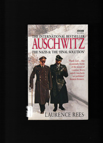
Book, Laurence Rees, Auschwitz : the Nazis & the 'final solution', 2013
This is the definitive screen history of the evolution of Auschwitz, how it fitted into the Nazis' plan for the conquest of the East and how scarcely a country in Europe was untouched by its existenceIndex, notes, ill, p.320.non-fictionThis is the definitive screen history of the evolution of Auschwitz, how it fitted into the Nazis' plan for the conquest of the East and how scarcely a country in Europe was untouched by its existenceauschwitz concentration camp - history, holocaust - jewish - 1939-1945 -
 Monbulk RSL Sub Branch
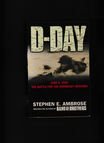
Book, Stephen E Ambrose, D-Day, June 6, 1944 : the climactic battle of World War II, 2004
On the basis of 1,400 oral histories from the men who were there, Eisenhower biographer and World War II historian Stephen E. Ambrose reveals for the first time anywhere that the intricate plan for the invasion of France in June 1944, had to be abandoned before the first shot was fired.Index, notes,ill, maps, p.655.non-fictionOn the basis of 1,400 oral histories from the men who were there, Eisenhower biographer and World War II historian Stephen E. Ambrose reveals for the first time anywhere that the intricate plan for the invasion of France in June 1944, had to be abandoned before the first shot was fired.operation overlord, world war 1939-1945 - campaigns - france -
 Monbulk RSL Sub Branch
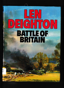
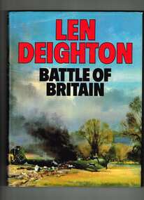
Book, Jonathon Cape, Battle of Britain, 1980
In this text, Deighton and Hastings look at how the few defended Britain in the Battle of Britain. They depict the reality of the battle and how it was enacted by those who took part, whether in the air, on the ground, in the planning rooms or at home in towns and villages.Index, ill, p.222.non-fictionIn this text, Deighton and Hastings look at how the few defended Britain in the Battle of Britain. They depict the reality of the battle and how it was enacted by those who took part, whether in the air, on the ground, in the planning rooms or at home in towns and villages. world war 1939-1945 - aerial operations, battle of britain - 1940 -
 Monbulk RSL Sub Branch
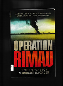
Book, Peter Thompson et al, Operation Rimau : Australia's heroic and daring commando raid on Singapore, 2015
In the last months of 1944, a group of elite Australian and British commandos was selected for the biggest Allied behind-the-scenes operation of the Pacific War. Their mission: to devastate the enemy's shipping by destroying the Japanese ships at anchor in Singapore Harbour. Operation Rimau, Britain's last throw of the colonial dice in South-East Asia, was intended as a body blow to the Japanese and a signal to the world that she would reclaim her Eastern Empire. Britain was trying to reclaim past glory - while Australia's wartime prime minister, John Curtin, had turned to America. In this atmosphere, Operation Rimau was planned ... Operation Rimau takes us inside the fierce conflict, and tells what really happened to these brave commandos - from the very beginnings of the operation through to their intense and courageous fighting in the South China Seas, and its aftermath. It exposes the sloppy planning behind the raid, and names the officers who betrayed and abandoned them in their hour of need, and details the political double-dealing which for so many years hid the real story behind red tape and bureaucratic lies.Index, bibliography,ill, maps, p.310.non-fictionIn the last months of 1944, a group of elite Australian and British commandos was selected for the biggest Allied behind-the-scenes operation of the Pacific War. Their mission: to devastate the enemy's shipping by destroying the Japanese ships at anchor in Singapore Harbour. Operation Rimau, Britain's last throw of the colonial dice in South-East Asia, was intended as a body blow to the Japanese and a signal to the world that she would reclaim her Eastern Empire. Britain was trying to reclaim past glory - while Australia's wartime prime minister, John Curtin, had turned to America. In this atmosphere, Operation Rimau was planned ... Operation Rimau takes us inside the fierce conflict, and tells what really happened to these brave commandos - from the very beginnings of the operation through to their intense and courageous fighting in the South China Seas, and its aftermath. It exposes the sloppy planning behind the raid, and names the officers who betrayed and abandoned them in their hour of need, and details the political double-dealing which for so many years hid the real story behind red tape and bureaucratic lies.world war 1939-1945 - covert operations - australia, krait (ship) -
 Monbulk RSL Sub Branch
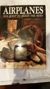
Mallard Press, Airplanes : our quest to reach the skies, 1990
... of the airplane and glances at future planes still in the planning stages ...A history of aviation that explores technological advancements and uses of the airplane and glances at future planes still in the planning stages.Index, bib, ill, p.147.non-fictionA history of aviation that explores technological advancements and uses of the airplane and glances at future planes still in the planning stages.airplanes - history, aeronautics - history -
 Monbulk RSL Sub Branch
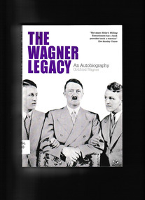
Book, Sanctuary, The Wagner legacy, 2000
Born in 1947, Gottfried grew up in post-war Bayreuth. In this atmosphere of deceit and discretion, he discovered the darker nature of his great-grandfather Richard Wagner's legacy: the intrinsic anti-Semitism in the composer's music and his heirs' beliefs; how Hitler proposed to Gottfried's English-born grandmother; how plans were drawn up to divide the world culturally, post Nazi victory, between Wolfgang and Wieland Wagner; and how the world of contemporary opera maintains and promotes anti-Semitic ideology even today.Index, ill, p.312.non-fictionBorn in 1947, Gottfried grew up in post-war Bayreuth. In this atmosphere of deceit and discretion, he discovered the darker nature of his great-grandfather Richard Wagner's legacy: the intrinsic anti-Semitism in the composer's music and his heirs' beliefs; how Hitler proposed to Gottfried's English-born grandmother; how plans were drawn up to divide the world culturally, post Nazi victory, between Wolfgang and Wieland Wagner; and how the world of contemporary opera maintains and promotes anti-Semitic ideology even today.germany - history, germany - anti-semitism -
 Monbulk RSL Sub Branch
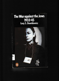
Book, Penguin, The war against the Jews, 1933-45, 1987
In the first part, "The Final Solution," the author "records the origins and growth of the virulent ideology that underlay the plan to annihilate the European Jews," and in the second part, "The Holocaust," she describes "the Jewish plight under German terror.Index, bib, maps, p.556.non-fictionIn the first part, "The Final Solution," the author "records the origins and growth of the virulent ideology that underlay the plan to annihilate the European Jews," and in the second part, "The Holocaust," she describes "the Jewish plight under German terror.holocaust - jewish - 1939-1945, 1939-1945 - atrocities -
 Monbulk RSL Sub Branch
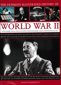
Book, Hermes House, The ultimate illustrated history of World War II : an authoritative account of one of the deadliest conflicts in human history with analysis of decisive encounters and landmark engagements, 2009
This history of the war has commentary on the political and economic factors leading to the conflict, the key turning points of the war and the impact of new technologies. Colour campaign maps and battle plans complement the description of every major battle on land and at sea, along with analysis of the success and failure of the various military strategies. It focuses on the key military figures who shaped the course of the war and describes all of the most successful weapons of war, with a specification box on each weapon providing key technical details.Index, ill, maps, p.256.This history of the war has commentary on the political and economic factors leading to the conflict, the key turning points of the war and the impact of new technologies. Colour campaign maps and battle plans complement the description of every major battle on land and at sea, along with analysis of the success and failure of the various military strategies. It focuses on the key military figures who shaped the course of the war and describes all of the most successful weapons of war, with a specification box on each weapon providing key technical details.world war 1939-1945 - history, world war 1939-1945 - campaigns -
 Monbulk RSL Sub Branch
Book, Jonathan Cape, Battle of Britain, 1980
In this text, Deighton and Hastings look at how the few defended Britain in the Battle of Britain. They depict the reality of the battle and how it was enacted by those who took part, whether in the air, on the ground, in the planning rooms or at home in towns and villages.Index, ill, p.224.non-fictionIn this text, Deighton and Hastings look at how the few defended Britain in the Battle of Britain. They depict the reality of the battle and how it was enacted by those who took part, whether in the air, on the ground, in the planning rooms or at home in towns and villages.world war 1939-1945 - battle of britain 1940, world war 1914-1918 - aerial operations - britain -
 St Kilda Historical Society
Photograph - Photo map, 28/01/1951
One of a series of photo-maps produced for the Department of Crown Lands and Survey (1857-1983). For correlation with a current map, and access to other historical photo maps of Victoria, see the Historic Photo-Maps Index published by the Department of Environment, Land, Water and Planning at https://services.land.vic.gov.au/DELWPmaps/historical-photomaps/Black and white aerial photograph1424-45 SECRET 534 Run 18 Lens 12" Melbourne Metropolitan 12150 28.1.51 M639albert park, st kilda junction, st kilda pier, catani gardens, st kilda, prahran, albert park lake, 1951, middle park, st kilda beach, windsor