Showing 34 items matching " kingston phillip"
-
 City of Kingston
Photograph - Digital image
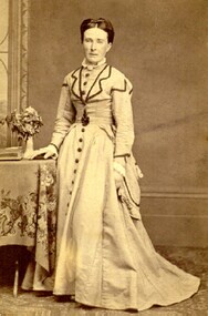
Sepia toned digital image of Isabella Macdonald nee Munroe (1820-1906) Born in Skye, Scotland, Isabella arrived in Melbourne on the 'Glen Huntly' on April 17, 1840. She died at Cranbourne in 1906.Isabella Munroe travelled to Australia with her mother, travelling under her maiden name of Mary McKenzie, on the Glen Huntley, arriving in the Port Phillip District 17 April 1840. The Glen Huntley arrived flying the yellow quarantine flag indicating it was carrying passengers with infectious diseases. Of a passenger complement of 170 passengers, during the voyage 105 contracted various diseases including fever, scarlatina, measles, small pox, and chicken pox. Both Mary and Isabella were held for a period in the camp at Little Red Bluff or Red Cliffs, known today as Point Ormond. Isabella married Alexander Macdonald at Scots Church, Melbourne on 17 February 1841. After their marriage they started the sheep run named Stringy Bark, on the Yarra, near where Kew is today. Sepia toned digital image of Isabella Macdonald standing beside a table. -
 City of Kingston
Photograph - Digital image, Colour
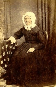
Mary Munro was the mother of Isabella Munro. They travelled to Australia together aboard the Glen Huntley, although Mary travelled using her maiden name of McKenzie. They arrived in Port Phillip District in 1840. After an arduous crossing, they were required to go into quarantine at Point Ormond on arrival as the ship had several outbreaks of infectious diseases and arrived flying the yellow quarantine flag. She died in 1882 at 'Wattle Grove', Mordialloc. Isabella went on to marry Alexander Macdonald.Hand tinted colour image of Mary Munro, nee McKenzie, wearing black dress and a white bonnet, tied at the chin. -
 Phillip Island and District Historical Society Inc.
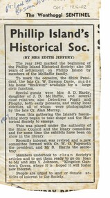
Article, Phillip Island Historical Society history 1967
... of the Historical Society Historical Phillip Island and District Historical ...Meeting at Erehwon to promote the re--establishment of the Historical SocietyHistoricalNewspaper article by Miss Edith Jeffery from The Wonthaggi Sentinel 1967.Phillip Island's Historical Soc by Miss Edith Jefferyphillip island and district historical society, cr dawson davie, miss edith jeffery, mrs s.d. hardy, detective piggit, detective phophy, cr. papworth, stan harris, kingston gardens -
 City of Kingston
Photograph - Colour, Circa 1993
Edithvale is a suburb in the City of Kingston. It is located between Aspendale and Chelsea on the Port Phillip Bay and built within remnant areas of the Carrum Carrum swamp. The foreshore precinct comprises a wide sandy beach, with low sand dunes and numerous historic boat sheds. The suburb consists of older style dwellings and former holiday houses, combined with mid-century housing and newer homes. The large blocks are increasingly subdivided and the existing dwellings demolished to accommodate units and townhouses, thus changing the landscape of the area and reducing the tree canopy.The beachside suburb of Edithvale was previously part of the extensive Carrum Carrum Swamp. The area was once a source of fish and eels for the Mayone-Bulluk clan of the Bunurong people. Over time the area was drained and predominantly devoted to dairy farming and holiday houses. The farms were gradually sold and subdivided with a large number of homes built after World War II and in the 1960s. Edithvale is mainly residential with a shopping strip along Nepean Highway but little significant industry was ever established in the area apart from a plaster works and confectionary factory, both now closed.Aerial colour photograph of Edithvale as viewed from Alexandra Avenue in the north to Ella Grove Chelsea/Edithvale in the south. The area is built-up with residential housing and facilities including Edithvale Primary School, numerous churches and the Edithvale Railway station. Large sections depict the remnant Carrum Carrum swamp. Edithvale Common and the former "Duck Inn" (Melbourne Water/Friends of Edithvale Seaford Wetlands) can be seen. Edithvale Recreational reserve, the velodrome and Edithvale Public Golf Course are prominent. The image shows vacant land in the area now known as Aspendale Gardens and the newer residential section of Chelsea Heights is not developed. A bike path has been established to cover the secondary drain. The Golf Links Court residential development located off Hughes Avenue is a large vacant block.Yellow circular adhesive sticker on plastic Black ink (marker): * (asterisk) Black type on white adhesive sticker: P000108edithvale, aspendale, chelsea, carrum carrum swamp