Showing 40 items
matching lower dam
-
 Bendigo Historical Society Inc.
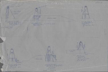
Map - SNOB'S HILL - PLAN OF SNOB'S HILL MINES
a. . Handdrawn copy of Snob's Hill Mines by Caleb Thomas (Long Section) 1885. Top drawing show mines and the distance between them. Lower drawing shows leases at a scale of 8 chains to 1 inch. Dams and sand heaps are included. The second page shows x-sections of the poppet legs and their heights. Shaft numbers are included. Two of the pulley diameters are also shown. b. Document headed Caleb Thomas cross sections 10.10.1884. South Catherine, engine east of shaft legs 44 ft high Ellenborough engine east of shaft, legs 40 feet Belmont and Saxby, engine and wheel west of shaft, legs 27 feet York and Durham, engine and wheel west of shaft legs 27 feet Snobs Hill , Old Williams, engine east of shaft legs 53 feet, L. Brace 21ft. 1884 Acadia Catherine engine west. Legs 44 feet, L.brace 11 ft.map, bendigo, goldfields, snob's hill, plan of snob's hill mines, caleb thomas, c reef united, catherine reef shaft, william's main, acadia, william's old main, gt northern, york & durham, snob's hill, belmont & saxby, ellenborough, st mungo, golden pyke, united c'holders, compy, snowdon & co, sth catherine coy, princess alice, saunders, williams & coy, acadia co, wearon & co, snob's hill, nelson trib, kneebone tribute, la belle co, york & durham, north st mungo, saxby & devonshire trib, n? trib, belmont co, durham c'land, kitti trib, sadowa trib, ran?eu co, nth devonshire co, lady barkly, devonshire reef trib, central devonshire co, j c macartney, catherine united -
 Tatura Irrigation & Wartime Camps Museum
Photograph, 1936
Photo taken by the photographer for Victoria State Rivers and Water Supply CommissionMedium sized black and white photograph. Eildon Reservoir dam wall / rock and earth fill wall from above / round concrete tower lower left / water above right / tree covered hill topgoulburn, irrigation, photo, victoria state rivers and water supply commission, eildon, eildon weir -
Tatura Irrigation & Wartime Camps Museum
Photograph, 13/04/1918
... / Original structure 1918 / Rock and earth fill dam wall / concrete... Weir / Original structure 1918 / Rock and earth fill dam wall ...Taken by photographer for State Rivers and Water Supply Commission.Medium sized black and white photograph. Eildon Weir / Original structure 1918 / Rock and earth fill dam wall / concrete spillway (lower left) / Water middle distance / hills beyondgoulburn weir, victorian state rivers and supply commission -
 Nillumbik Shire Council
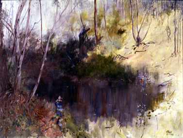
Painting: Tony Harkin (b.1938 Aus), Bush Study, 1982
Landscape painting of "a pool of water" and its surrounding Australian bush landscape. May be a reference to the Black Dam near Dunmoochin, Cottles Bridge.Signed and dated lower right corner "Harkin 1982"landscape, eltham, dam, cottles bridge, water, bush -
 Southern Sherbrooke Historical Society Inc.
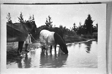
Photograph - Horses at dam, Belgrave Heights
Photograph of three horses drinking by damn near Marama Rd, Belgrave Heights. Behind the horse on the far left, a person is holding the horse. Their lower body is visible. Trees are in the background. Probably taken by Betty de Coite nee Woods or her parents. -
 Stawell Historical Society Inc
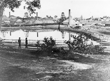
Photograph, The Pleasant Creek Cross Reef No1 Shaft Panorama of a Mining Scene in the Duke Sands area c1875
... dam. Two Gentlemen lower left corner... is one of the Moonlight dams. St Peters Lutheran Church ...Mining Scene Duke Sands area c1875 Behind the tree on left is Extended Cross Mine and on the right is the Oriental Mine. In the centre is the North Cross Mine No1 shaft. In the foreground is one of the Moonlight dams. St Peters Lutheran Church in Scallan Street can be seen on the right horizon. Two mines and workings on other side of Moonies settling dam. Two Gentlemen lower left cornerstawell mining -
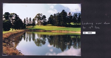 Heidelberg Golf Club
Photograph, Looking over dam to 17th tee: Heidelberg Golf Club, 2000c
Looking over dam to 17th tee: Heidelberg Golf ClubColour photograph and caption.hgc course, 17th tee, dams -
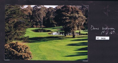 Heidelberg Golf Club
Photograph, Dams between 1st and 16th fairways: Heidelberg Golf Club, 2000c
... Heidelberg Golf Club 8 Main Road Lower Plenty 3093 Dams ...Dams between 1st and 16th fairways: Heidelberg Golf ClubColour photograph and caption.hgc course, 1st fairway, 16th fairway, dams -
 Bendigo Historical Society Inc.
Document - DRAINAGE PROBLEMS - MINERS SENSATIONAL EXPERIENCE AT THE VICTORIA QUARTZ
Handwritten notes from a Bendigo Advertiser report, Thursday June 16th 1910. Management had for some time been apprehensive that the flooding in the deep mines to the south would affect them. Lansell's 180 took the precaution of baling. On the Tuesday night the men at the Victoria Quartz had a sensational experience. The storage dam at 3324 ft level receives the overflow from the flooded mines to the south. The level connects with the 3310 level at the Big 180. The water flows uninterrupted into thestorage dam which has a capacity of about 270 tanks. The dam had been emptied on Tuesday morning and work continued until 10 pm that night. The platman noticed that the water was coming down the shaft in a regular torrent. They didn't take much notice as they thought it was a leakinig outlet valve on the ascending tank. At 11 pm the releiving shift came down the shaft and said that the dam at 3,324 ft must be overflowing. The velocity of the water pouring down the shaft increased and the men made a hurried exit from the bottom of the shaft which is down 310 ft from the 4.254 ft plat (a total depth of 4,564 ft). An inspection of the dam at the 3324 ft level found it to be overflowing. By morning (Wednesday) the shaft had filled, and the water rose to 7 ft in the plat at 4254 feet. Mining inspector hgave orders that men were not to go below the 3324 ft level. Baling continued without cessation at the Big 180 all day and could not lower the water. Drilling machines etc and a powerful air winch at the 4254 ft plat are under water. An inspection made of the 3100 ft level at the 180 mine where the workings are connected with the New Chum & Victoria showed that water was running strongly from that mine proving that the inrush was due to flooded water from the southern deep mines to the south. Document from Albert Richardson Collection of mining history. Document from Albert Richardson Collection of mining history.document, gold, drainage problems, new chum drainage scheme, miners sensational experience at the victoria quartz, bendigo advertiser 16/6/1910 page7, lansell's 180, big 180, new chum & victoria -
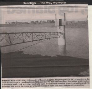 Bendigo Historical Society Inc.
Newspaper - JENNY FOLEY COLLECTION: WHEN IT WAS FULL
BHS CollectionBendigo advertiser ''The way we were'' from 2003. When it was full: Brian Hollingworth of Epsom, supplied this photograph of the construction of the tower access bridge at lake Eppalock in 1962, just after the dam was completed. The bridge, which reaches to the intake tower, took about two months to build. It was built on the bank in sections and lowered into the water. The end of the bridge lay under 20 metres of water until lifted and placed into position. The clip is in a folder.newspaper, bendigo advertiser, the way we were