Showing 1772 items
matching maps and plans
-
 Bendigo Historical Society Inc.
Map - LYELL, 4/06/1873
Map: Lyell. Parish plan (number 278 in map cupboard 1)map, bendigo, parish plan, lyell -
University of Melbourne, Burnley Campus Archives
Plan - Photocopy, Sunshine Planning Scheme, 1993
Photocopies. 18.02.1993. (1) 5 copies Map User Guide - Sunshine Planning Scheme. List of Zones, Reservations and additional Planning Controls. (2) Sunshine Planning Scheme - Local Section. Zones and Reserved Land Map No 2. (3) Map No 3. (4) Map No 4. Used in planning Native Garden Woodlandsunshine, reservations, native garden, planning scheme, victoria department of planning and development -
Whitehorse Historical Society Inc.
Document, Eastern Freeway Extension, 2000 - 2002
... Maps ...Eastern Freeway ExtensionEastern Freeway Extension- Cost estimates for community consultation option Public consultation process : report on analysis submissions Deep Creek Road - Landscape concept Media Release from Premier of Victoria VicRoads - Works update newsletters Whitehorse City Council minutes VicRoads Correspondence Schwerkolt Cottage Precinct - Concept Plan VicRoads maps.Eastern Freeway Extensioneastern freeway extension, vicroads, victoria. department of infrastructure, city of whitehorse, schwerkolt cottage, landscape planning, maps -
 Monbulk RSL Sub Branch
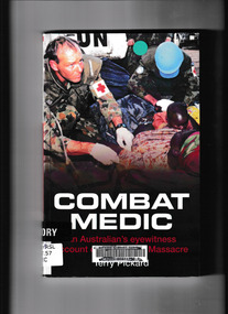
Book, Big Sky Publishing, Combat medic : an eyewitness account of the Kibeho massacre, 2008
On the 22nd of April 1995 more than 4,000 Rwandans were massacred and thousands more injured in a place called Kibeho. Terry Pickard, a seasoned soldier and medic, was one of a 32-strong force of Australian UN peacekeepers in Kibeho on that terrible Saturday. While the United Nations’ presence prevented the death toll from being even worse than it was, the massacre continues to haunt him. The rules of engagement that stopped him from intervening in the senseless slaughter, and the life and death decisions he was forced to make when dealing with the injured condemned him to more than a decade of recurring nightmares and debilitating flashbacks. The horror and unimaginable tragedy of the Kibeho Massacre still looms large in the lives of Rwandans and the people sent to help the African country. No one who walked away from that day was ever the same again. Combat Medic is a personal account of one Australian soldier who found himself at the centre of events that shocked the world, and the personal toll that he paid. Terry Pickard’s army career spanned nearly 20 years. More than 25 years after Rwanda he continues to struggle with post traumatic stress triggered by his experiences. Collapse summaryIll, maps, plans, p.181.non-fictionOn the 22nd of April 1995 more than 4,000 Rwandans were massacred and thousands more injured in a place called Kibeho. Terry Pickard, a seasoned soldier and medic, was one of a 32-strong force of Australian UN peacekeepers in Kibeho on that terrible Saturday. While the United Nations’ presence prevented the death toll from being even worse than it was, the massacre continues to haunt him. The rules of engagement that stopped him from intervening in the senseless slaughter, and the life and death decisions he was forced to make when dealing with the injured condemned him to more than a decade of recurring nightmares and debilitating flashbacks. The horror and unimaginable tragedy of the Kibeho Massacre still looms large in the lives of Rwandans and the people sent to help the African country. No one who walked away from that day was ever the same again. Combat Medic is a personal account of one Australian soldier who found himself at the centre of events that shocked the world, and the personal toll that he paid. Terry Pickard’s army career spanned nearly 20 years. More than 25 years after Rwanda he continues to struggle with post traumatic stress triggered by his experiences. Collapse summary united nations - peacekeeping forces - rwanda, rwanda - civil war - atrocities -
Stawell Historical Society Inc
Map, R.O. Robson - Authorised Surveyor, Road from Glenorchy to near Geary's Selection Callawaddy 1880, 29.04.1880
Survey for Road CreationCloth Backed Map. Plan of Road.Parishes of Richella & Callawadda. County of Borong. Plan of Road. R.O. Robson Authorised Surveyor Stawell 29.04.80 -
 Bendigo Historical Society Inc.
Map - REDCASTLE AND DARGILE, No date visible
Map: Redcastle and Dargile. Parish planPencil markings 27/6/78, 18/10/78map, parish plan, redcastle, dargile -
Bendigo Historical Society Inc.
Map - HUNTLY RESURVEY, 1873
Map: Huntly resurvey. Parish plan ( number 242 in Map Cupboard 1)map, bendigo, parish plan, huntly -
Bendigo Historical Society Inc.
Map - MUSKERRY, No date visible
Map: Parish of Muskerry. Parish plan (number 310 in map cupboard 1)map, parish plan, muskerry -
University of Melbourne, Burnley Campus Archives
Plan, Keilor Planning Scheme, 1993
Photocopies. 18.02.1993. (1) 5 copies Map user guide - Keilor Planning Scheme, List of Zones Reservations and additional Planning Controls. (2) Keilor Planning Scheme - Local Section. Zones and Reserved Land Map No. 7. (3) Map No 9. Also 3 photocopies of maps joined together. Used in planning Native Garden Woodland Section.keilor, native garden, reservations, planning scheme, zoning, victoria department of planning and housing -
 Warrnambool and District Historical Society Inc.
Ledger, Chadwick Copying Book Co, Letter book 1905, 1902
This letter book has maps, letters and plans dating from 1902 to 1905. It came from the office of John William Crawley, Junior, an engineer, architect and surveyor in private practice in Warrnambool and also the engineer for the Shire of Warrnambool from 1895 to 1935. His father, brother and son were all engineers and worked in that capacity or as Shire Secretary for the Shire of Warrnambool, with the Crawley family recording a total of 132 years of service to the Shire of Warrnambool. The Shire of Warrnambool existed from 1863 to 1994. This letter book was passed on to John Crawley’s son, Rolf, engineer for the Shire of Warrnambool from 1935 to 1968. The letter book then came into the possession of Michael Hand who took over the private surveying business of Rolf Crawley in Warrnambool. The Warrnambool and District Historical Society acquired the letter book, along with several other Crawley ledgers, from the Michael Hand estate. This letter book is of considerable importance as it contains the letters, maps and plans produced by John William Crawley Junior, a Shire of Warrnambool engineer for 40 years. It will be useful to researchers. This is a black hard cover letter book of 505 pages, plus an alphabetical index at the back of the book. The letter book contains handwritten letters, sketch maps and plans. There is gold lettering on the spine.‘1’ ‘Invoice’ ‘Chadwick Copying Book Co. Springfield Mass.’ john william crawley, junior, warrnambool, rolf crawley, warrnambool, shire of warrnambool, history of warrnambool -
 Bendigo Historical Society Inc.
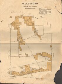
Map - JACK FLYNN COLLECTION: WELLSFORD, 15/12/1941
Map: Parish of Wellsford, County of Bendigo. Parish plan. 2 copies of the same plan.map, bendigo, parish plan, wellsford -
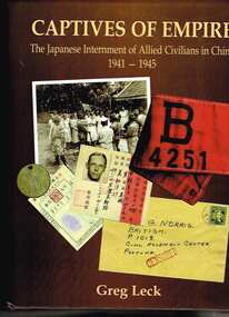 Monbulk RSL Sub Branch
Book, Shandy Press, Captives of empire : the Japanese internment of allied civilians in China, 1941-1945, 2006
Here for the first time is the definitive history of the internment of Allied civilians ib ChinaIndex, ill, maps, plans, p.738.Here for the first time is the definitive history of the internment of Allied civilians ib Chinaworld war 1939-1945 - prisoners and prisons - japan, internment camps - china -
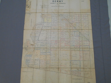 Bendigo Historical Society Inc.
Map - JACK FLYNN COLLECTION: DERBY, 12/05/1892
Map: Derby, County of Bendigo. Parish plan.Department of Lands and Survey Melbourne by T.F.McGauran, 12.5.92map, bendigo, parish plan, derby -
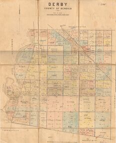 Bendigo Historical Society Inc.
Map - JACK FLYNN COLLECTION: DERBY, 1/09/1909
Map: Derby, County of Bendigo. Parish plan.Dept of Lands and Survey, Melbourne by T.E.McGauran 1.9.09map, bendigo, parish plan, derby -
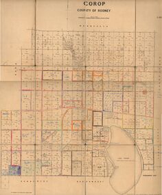 Bendigo Historical Society Inc.
Map - JACK FLYNN COLLECTION: COROP, 8/08/1929
Map: Corop, County of Rodney. Parish plan.By Authority H. J. Green, Govt. Printer, Melb. Dept of Lands and Survey Melbourne by Price 8.8.29map, rodney, parish plan, corop, county of rodney -
 Bendigo Historical Society Inc.
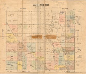
Map - JACK FLYNN COLLECTION: YARRABERB, 2/03/1931
Map: Yarraberb, County of Bendigo. Parish plan.By Authority H.J. Green Govt., Printer. Photo Lithographed at the Department of lands and Survey Melbourne, 2.3.31.map, bendigo, parish plan, yarraberb -
 Bendigo Historical Society Inc.
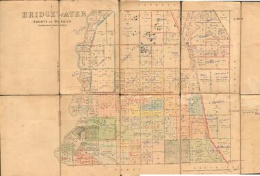
Map - JACK FLYNN COLLECTION: BRIDGEWATER, 6/10/1927
Map: Bridgewater , County of Bendigo. Parish plan.Photo Lithographed at the Department of Lands and Survey, Melbourne by W.J. Butson.map, bendigo, parish plan, bridgewater -
Bendigo Historical Society Inc.
Map - COLBINABBIN, June 1951
Map: Colbinabbin, County of Rodney. Parish planmap, rodney, parish plan, colbinabbin, county of rodney -
Bendigo Historical Society Inc.
Map - TARNAGULLA SHEET 2, No date Visible
Map: Tarnagulla Sheet 2, Parish planmap, parish plan, tarnagulla -
 Bendigo Historical Society Inc.
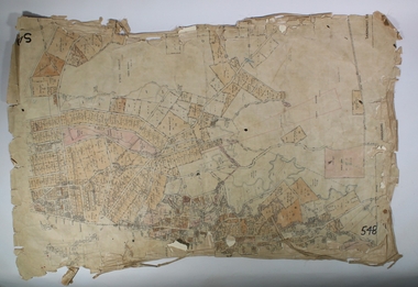
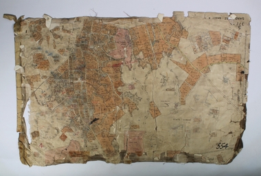
Map - SANDHURST SHEET 3, June 29th 1967
Map: Sandhurst sheet 3. Parish plan.map, bendigo, city streets, sandhurst, early bendigo -
 Bendigo Historical Society Inc.
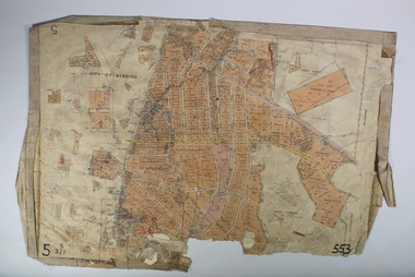
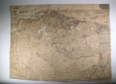
Map - SANDHURST SHEET 2, March 12th 1867
Map: Sandhurst sheet 2 . Parish plan.map, bendigo, city streets, sandhurst, early bendigo -
 Mrs Aeneas Gunn Memorial Library
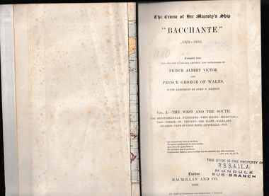
Book, McMillan and Co et al, The cruise of Her Majesty's ship Bacchante, 1879-1882 v.1, 1886
A description of a world cruise taken by Prince Albert Victor and Prince George of Wales.Ill, charts, maps, plans, p.675.non-fictionA description of a world cruise taken by Prince Albert Victor and Prince George of Wales.australia - description and travel, voyages around the world -
 Mrs Aeneas Gunn Memorial Library
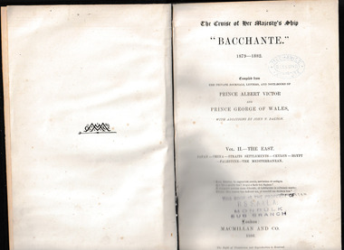
Book, McMillan and Co et al, The cruise of Her Majesty's ship Bacchante, 1879-1882 v.2, 1886
A description of a world cruise taken by Prince Albert Victor and Prince George of Wales.Ill, charts, maps, plans, p.803.non-fictionA description of a world cruise taken by Prince Albert Victor and Prince George of Wales.australia - description and travel, voyages around the world -
 Bendigo Historical Society Inc.
Map - SANDHURST,. SHEET ?, 24/04/1907 ?
Map: Sandhurst (sheet No. missing). Parish planmap, bendigo, parish plan, sandhurst -
 Bendigo Historical Society Inc.
Map - SANDHURST, SHEET ?, Date missing
Map: Sandhurst (sheet No., Missing) P_arish planmap, bendigo, parish plan, sandhurst -
 Bendigo Historical Society Inc.
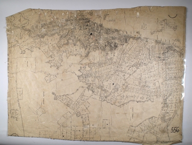
Map - SANDHURST SHEET 4, No date visible
Map: Sandhurst sheet 4. Parish planmap, bendigo, parish plan, sandhurst -
 Bendigo Historical Society Inc.
Map - SANDHURST SHEET 2, 14/03/1923 ?
Map: Sandhurst sheet 2. Parish planmap, bendigo, parish plan, sandhurst -
 Bendigo Historical Society Inc.
Map - SANDHURST SHEET 2, Date unreadable
Map: Sandhurst sheet 2. Parish planmap, bendigo, parish plan, sandhurst -
 Bendigo Historical Society Inc.
Map - SANDHURST SHEET 4, 11/03/1925
Map: Sandhurst sheet 4. Parish planmap, bendigo, parish plan, sandhurst -
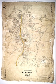 Bendigo Historical Society Inc.
Map - MANDURANG, 10/11/1909
Map: Mandurang, County of Bendigo. Parish planmap, bendigo, parish plan, mandurang