Showing 1173 items
matching mornington
-
 Eltham District Historical Society Inc
Book, Melway Great Melbourne street directory including Geelong, Phillip Island Healesville, Bellarine & Mornington Peninsulas, 1998
25th edition. Coloured detailed maps accessed by a street or location index. Cover: (Includes) New Southbank map including Crown Complex, enlargements of Footscray and Kensington, bike paths, walking tracks & horse trails, latest public transport information, South east Australia tours maps, Vic Roads new route numbers, map of Australia1 atlas (22, 772 p.) : col. maps ; ISSN 03113957streets, maps, roads, melbourne -
 Eltham District Historical Society Inc
Book, Melway Publishing, Melway Greater Melbourne street directory : including Geelong, Phillip Island, Healesville, Bellarine & Mornington Peninsulas, 2002
Edition 29. Coloured detailed maps accessed by a street or location index. Cover: 20 additional pages of new maps, extended coverage of Bellarine Peninsula, further coverage of Werribee South, Public Transport Information, latest official suburb boundaries, CBD "hook turn" intersections map, over 1200 new streets, 1 atlas (24, 886 p.) : col. maps ; ISSN 03113957streets, roads, melbourne, maps, melway -
 Eltham District Historical Society Inc
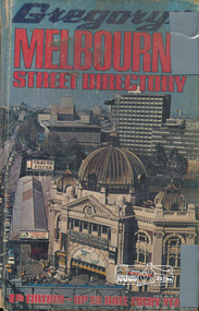
Book, Gregory's Melbourne Street Directory of Melbourne and suburbs and metropolitan road guide (8th edition) extends to Laverton, Deer Park, Epping, Diamond Creek, Lilydale, Olinda, Belgrave, Doveton and Mornington, 1973
This is the 8th edition of Gregory's Melbourne Street Directory, fully revised and up-to-date for this edition published December 1973. It is a comprehensive guide to the streets and localities of Melbourne and suburbs at that time. The colour maps are arranged in double-page spreads. Names of streets and suburbs are arranged alphabetically in the index to streets.Hard copy with plastic cover. 382 p. streets, melbourne - maps, roads -
 Ringwood and District Historical Society
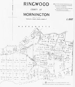
Photograph, Parish map of Ringwood, County of Mornington - 1878
Copyright note states "Crown (State of Victoria) Copyright 1973"Written on backing sheet, "SLV Parish Map Collection Vol.23, Fol.64". -
 Ringwood and District Historical Society
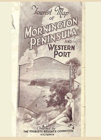
Memorabilia, Tourist Map of Mornington Peninsula and Western Port - 1929
Multi-fold pictorial map of towns, railways and main roads east of Port Phillip Bay from Melbourne to Yarra Junction and south to Phillip Island and Wonthaggi, backed by details of main features and points of interest.Photo-Lithographed by Department of Lands and Survey, Melbourne, 2.8.1929. -
 City of Moorabbin Historical Society (Operating the Box Cottage Museum)
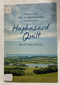
Book, Bates, Weston, Haphazard quilt [kit] : poems of the Mornington Peninsula, 2006
Contents: Imara -- Imaretta -- Tortise head -- Foxey's hangout -- Near Shoreham -- Golfers at Flinders --- Banksias -- Bittern cottage -- Somers. "Original music from cellist Richard Vaudrey"-- front cover CD. Recorded and produced by Owen Armour.Book with a CDfictionContents: Imara -- Imaretta -- Tortise head -- Foxey's hangout -- Near Shoreham -- Golfers at Flinders --- Banksias -- Bittern cottage -- Somers. "Original music from cellist Richard Vaudrey"-- front cover CD. Recorded and produced by Owen Armour.poems, mornington peninsula -
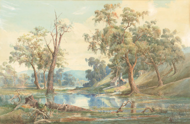 Benalla Art Gallery
Watercolour, Charles BENNETT, Pioneer’s cottage, Mornington, 1891
Born: South Yarra, Victoria, Australia 1869; Died: Mornington, Victoria, Australia 1930VictorianLedger Gift, 1985Sunlit rural landscape with buildings, figures, wagon, trees, water, reflections and a hill. Gold brushed ornate timber frame.Recto: Signed and dated "C. S. BENNETT / 1891" in brown watercolour in l.r.c; Not titledwatercolour, landscape, riverscape, house, trees, water, reflection -
 Victorian Aboriginal Corporation for Languages
Book, Melway Publishing, Melway Greater Melbourne street directory : including Geelong, Phillip Island, Healesville, Kinglake, Gisborne, Lorne, Wallan, Bacchus Marsh, Bellarine &? Mornington Peninsulas, 2005
Street directory including the wider area surrounding Melbourne.mapsmaps, victorian street maps, street directories, road maps -
 Victorian Aboriginal Corporation for Languages
Book, Kathie Strickland et al, Peninsula plants : a field guide to indigenous plants of the Mornington Peninsula suitable for cultivation, 1995
One plant detailed per double page, with clear illustrations and descriptions.B&w illustrations, glossaryindigenous plants, vegetation, species guide -
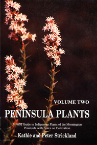 Victorian Aboriginal Corporation for Languages
Book, Kathie Strickland et al, Peninsula plants : volume two : a field guide to indigenous plants of the Mornington Peninsula with notes on cultivation, 1992
One plant detailed per page, with clear illustrations and descriptions.b&w illustrations, glossaryindigenous plants, vegetation, species guide -
 Kingston Arts
Painting, R. Russell Fletcher, Mornington Mooring
-
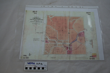 Emerald Museum & Nobelius Heritage Park
Map, Township of Emerald, Parish of Gembrook, counties of Evelyn and Mornington
Map showing property owners, posted 12 September 1956Includes Ferntree Gully to Gembrook Railway and Property Owners (coloured in pink). -
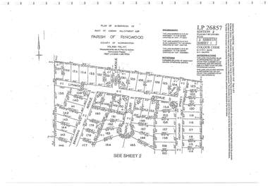 Ringwood and District Historical Society
Document - Subdivision Plan, Part of Crown Allotment 32B Parish of Ringwood, County of Mornington Vol 6051 Fol 111 - LP26857
LANDATA Land Victoria 2-sheet plan printout dated 9/11/1953.Sheet 1 includes Lynwood Avenue, Isabel Avenue, Braewood Avenue, Maple Court, and Heathwood Street, Ringwood East, Vic. Sheet 2 includes Braewood Avenue, Rotherwood Avenue, and Heathwood Street, Ringwood East, Vic. Additional markings include LP46598, CP173330, LP86847, LP213448, LP217511, LP207217, LP56241. -
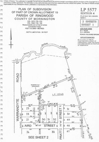 Ringwood and District Historical Society
Document - Subdivision Plan, Part of Crown Allotment 19 Parish of Ringwood, County of Mornington Vol 3375 Fol 910 & Vol 3526 Fol 159 - LP5577
LANDATA Land Victoria 2-sheet plan printout dated 6/9/2011.Sheet 1 includes Warrandyte Road, Aird Street, and Pratt Street, Ringwood, Vic. Additional markings include LP19568 Sheet 2 includes Warrandyte Road, Aird Street, Pratt Street, and White Horse Road, Ringwood, Vic. Additional markings include SP25671H, CP100154, LP10519, LP28996 and P51182. -
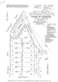 Ringwood and District Historical Society
Document - Subdivision Plan, LP12308 Crown Allotment 14C and Part of Crown Allotment 14A Parish of Ringwood, County of Mornington Vol 5378 Fol 511 - Circa 1927
LANDATA Land Victoria 4-sheet plan printout dated 2009.Sheet 1 includes Canterbury Road, Heathmont Road, Dickasons Road and Bennett Avenue, Heathmont. Additional markings include PC353066. Sheet 2 includes Heathmont Road, Bennett Avenue and Orchid Street, Heathmont. Additional markings include PS326369 and SP24567. Sheet 3 includes Dickasons Road and Bennett Avenue, Heathmont. Additional markings include LP46776, SP28005 and PS335189. Sheet 4 includes Dickasons Road, Bennett Avenue and Orchid Street, Heathmont. Additional markings include SP25998, SP31080, SP31780, SP25968, SP25969 and LP46475. -
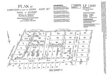 Ringwood and District Historical Society
Document - Subdivision Plan, LP11645 Part of Crown Allotment 26A, Parish of Ringwood, County of Mornington Vol 5164 Fol 1032616 - 1926
LANDATA Land Victoria 2-sheet plan printout dated 2009Sheet 1 includes Mount Dandenong Road, Valda Avenue and Velma Grove, Ringwood East. Additional markings include SP35514, SP22189, SP34206, SP35514, SP26794, PS319109, PS319010 and PS304868. Sheet 2 includes Mount Dandenong Road, Valda Avenue, Mirabel Avenue and Velma Grove, Ringwood East. Additional markings include SP26430, SP25320, PS341575, PS319110, PS319010, LP48415, SP22732, SP25844, PS304936 and PS304937. -
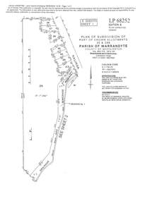 Ringwood and District Historical Society
Document - Subdivision Plan, LP113220 Part of Crown Allotments 35 & 39B, Parish of Warrandyte, County of Mornington, Vol 6421 Fol 183 & 184 - 1965
LANDATA Land Victoria 2-sheet plan printout dated 2009Sheet 1 includes Kalinda Road, Ringwood. Additional markings include LP113117. Sheet 2 includes Kalinda Road and Maroondah Highway, Ringwood. Additional markings include LP86253. Both sheets include location of Drainage and Sewerage Reserve along Mullum Mullum Creek. -
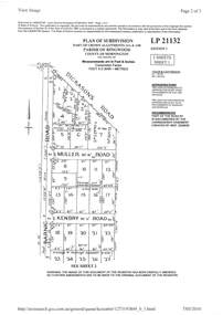 Ringwood and District Historical Society
Document - Subdivision Plan, LP21132 Part of Crown Allotment 14A & 14B, Parish of Ringwood, County of Mornington Vol 4929 Fol 657 - (Undated, circa 1920s/30)
LANDATA Land Victoria 2-sheet plan printout dated 2010.Sheet 1 includes Dickasons Road, Barnic Road, Muller Road and Kenbry Road, Heathmont. Sheet 2 includes Barnic Road and Possum Lane, Heathmont. Additional markings include LP83779. -
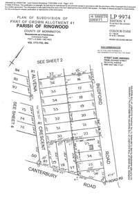 Ringwood and District Historical Society
Document - Subdivision Plan, LP9974 Part of Crown Allotment 41, Parish of Ringwood, County of Mornington Vol 1773 Fol 464 - 1924
LANDATA Land Victoria 4-sheet plan printout dated 2009Sheet 1 includes Alvena Crescent, Bedford Road and Canterbury Road, Heathmont. Additional markings include RP16869. Sheet 2 includes Alvena Crescent and Bedford Road, Heathmont. Additional markings include PS318390 and CP161633. Sheet 3 includes Bedford Road, Alvena Crescent and Royal Avenue, Heathmont. Additional markings include RP454. Street name amended from Leonard Street to Royal Avenue Vide Gaz 1962 P.427. Sheet 4 includes Alvena Crescent, Royal Avenue, Coleman Street and Canterbury Road, Heathmont. Additional markings include SP27861, PS305057, RP10566, SP34722 and LP116573. -
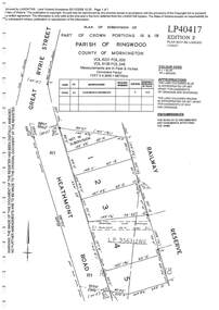 Ringwood and District Historical Society
Document - Subdivision Plan, LP40417 Part of Crown Portions 16 & 18, Parish of Ringwood, County of Mornington, Vol 6231 Fol 035 and Vol 8139 Fol 248 - 1957
LANDATA Land Victoria plan printout dated 2008Map includes Heathmont Road, Heathmont, with allotments adjoining Railway Reserve. Other markings include LP95632NS. -
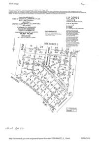 Ringwood and District Historical Society
Document - Subdivision Plan, LP26914 Multiple Crown Allotments, Parish of Ringwood, County of Mornington, Vol 8021 Fol 053 - 1954
LANDATA Land Victoria plan printout dated 2010Part of Crown Allotments 1, 1A, 2, 3, 4, 5, 6, 7, 8, 9, 10, 55, 56, 57. Section C Crown Allotments 3, 12 & part of 2. Section B Map includes Bedford Road, Government Road (later Bedford Park Road then Hill Street), Marwarra Street and Tooronga Road, Ringwood. (Sheet 1 of 2 - Sheet 2 not included with collection). -
 Ringwood and District Historical Society
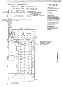
Document - Subdivision Plan, LP23855 Part of Crown Allotment 14B, Parish of Ringwood, County of Mornington, Vol 6687 Fol 394 - 1952
LANDATA Land Victoria plan printout circa 2008Map includes Cuthbert Street, Orchard Grove, and Lowen Avenue (formerly part of Balfour Avenue), Heathmont. Other markings include SP25736, LP98835 and LP40209. -
 Ringwood and District Historical Society
Document - Subdivision Map, Part of Crown Portion 22 Parish of Ringwood, County of Mornington. Vol 1915 Fol 827 - LP2427
LANDATA Land Victoria 4-sheet plan dated January 2003 - copy of original 1889 subdivision, amended with 1947 amendments by Assistant Registrar of Titles.Sheet 1 includes Main Lilydale Road (later Old Lilydale Road), Wandin Road (later Mount Dandenong Road), and Joseph Street, Ringwood East. Additional Plan markings SP30844, SP32804, LP144251, PS332061, PS305232. Sheet 2 includes Main Lilydale Road (later Old Lilydale Road), Wandin Road (later Mount Dandenong Road), and Dynes Street, Ringwood East. Additional Plan markings LP43708, LP44231, LP124702. Sheet 3 includes Main Lilydale Road (later Old Lilydale Road), Dynes Street, Albert Street (later Wyrunga Street), and Carcoola Road, Ringwood East. Additional Plan markings LP114181, LP114180, LP18261, LP214030, LP67300, PS354509, PS335500. Sheet 4 includes Main Lilydale Road (later Old Lilydale Road), Albert Street (later Wyrunga Street), and Carcoola Road, Ringwood East. Additional Plan markings PS315494, PS319495. -
 Ringwood and District Historical Society
Document - Map, Plan of Subdivision - Part of Crown Allotments 14A & 14C, Parish of Ringwood, County of Mornington, Vol 5378 Fol 511 - 1927
Department of Lands and Survey photocopy dated 17/1/1951, page number 12308.Map includes Canterbury Road, Heathmont Road, Dickasons Road, Bennett Avenue, Orchid Street and Allens Road, Heathmont, Vic. -
 Ringwood and District Historical Society
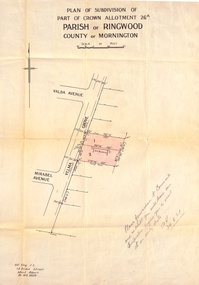
Document, Plan of Subdivision - Part of Crown Allotment 26A, Parish of Ringwood, County of Mornington - Circa 1961
Map showing layout of 2 allotments coloured red in Velma Grove, adjacent to Valda Avenue and Mirabel Avenue, Ringwood East, Vic.Handwritten notation dated 29/8/1961 by Alf King, Licensed Surveyor, 14 Grace Street, Mont Albert (Phone) WX2020 regarding plans being forwarded to Council for inspection visit. -
 Ringwood and District Historical Society
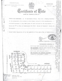
Document, Certificate of Title Vol 8633 Fol 471, Plan of Subdivision No. 73512, Parish of Ringwood, County of Mornington
A4 Title Search Enquiry printout dated 2003, with Subdivision Map including Fairbank Avenue and Woodlands Road, Heathmont, Vic.Issued under Regulation 12 on the approval of the above Plan of Subdivision. Derived from Vol 8618 Fol 718, 26/8/1966. Proprietor - Donald Ian Carmichael of 37 Dorrington Avenue Glen Iris. -
 Ringwood and District Historical Society
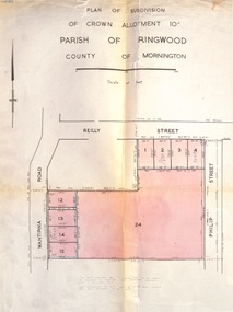
Document, Plan of Subdivision - Part of Crown Allotment 10A, Parish of Ringwood, County of Mornington - 1957
Map of residential allotments in Wantirna Road and Reilly Street, Ringwood, and Philip Street, Heathmont, Vic.Footnote includes "Lots numbered 5 to 11 and 16 to 23 both inclusive are not included in this plan. Signature of Consulting Engineer - Alan J. Brown BCE, LS, MVIS, Licensed Surveyor, Dillons Buildings, 1 Riversdale Road, Camberwell (Phone) WF3528 dated 1-4-1957. -
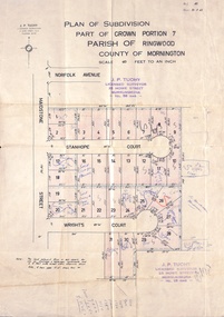 Ringwood and District Historical Society
Document, Plan of Subdivision - Part of Crown Portion 7, Parish of Ringwood, County of Mornington - 1962
Map of residential allotments coloured red, with land coloured blue set apart for drainage & sewerage easements. Rubber stamped J.P. Tuohy, Licensed Surveyor, 25 Howe Street Murrumbeena, Tel. 561945, dated 38.8.1962.Map includes Maidstone Street, Norfolk Avenue, Stanhope Court and Wrights Court, Ringwood, Vic. Also includes handwritten Estate Agent sales notations. -
 Narre Warren and District Family History Group
Book, Doug Thompson, From conflict to reform : from 5-1-1798 Geo. Bass into Mornington Peninsula Shire constituted 15-12-1994, 1997
Part autobiography of Doug Thomspon, part history of Hastings Shire and the Hastings - Western Port Historical Society.non-fictionPart autobiography of Doug Thomspon, part history of Hastings Shire and the Hastings - Western Port Historical Society. shire of hastings, western port settlement, douglas m thompson -
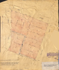 Ringwood and District Historical Society
Document - Plan of Subdivision, Parts of Crown Allotments 45 & 46, Township & Parish of Ringwood, County of Mornington - 1950
Map on manila folder attached to cardboard backing showing residential allotments on King Street and Holland Road, Ringwood East.Signature of Russell Francis Kinnane, Licensed Surveyor, 4th December, 1950.