Showing 8857 items
matching on the lake
-
 Tatura Irrigation & Wartime Camps Museum
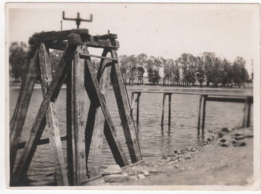
Photograph, Daryl Walker, Lake Bartlett
Lake Bartlett, Tatura, named after the Bartlett family who conducted the business, Bartlett Cordials, for many years. Tatura Primary School is beside it. A cricket oval and activity centre is at the rear.Black and white photograph of Lake Bartlett, Service Street Tatura.on back: Lake Bartlett, Tatura 1986. On wooden sign Lake Bartlettlake bartlett tatura -
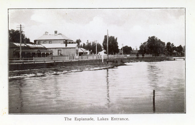 Lakes Entrance Historical Society
Postcard - Lakes Entrance, 1920c
Also black and white 9 x 14 cm copy, but not Vogt, inscription The Esplanade, Lakes EntranceBlue and white postcard showing a section of the western end of Esplanade, showing lake, foreshore, Vize's Cafe, Bellevue Guest House, Police Station, Maranui Guest House and, partially hidden by trees, residential houses. Lakes Entrance VictoriaLakes Entrance The Esplanadeguesthouses, township, police, retail trade -
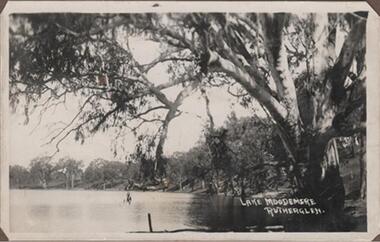 Rutherglen Historical Society
Photograph - Image, 1914-1920 (Approximate)
Lake Moodemere has always been a beauty spot & picnic area for the locals, today many speedboats use it for water skiing, it is a wildlife sanctuaryBlack & white photograph, unframed but pasted to pages of an album. Lake Moodemere, Rutherglen"Lake Moodemere Rutherglen" -
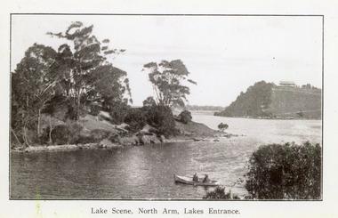 Lakes Entrance Historical Society
Photograph - North Arm, 1920c
Copy same view but titled 'North Arm - Lakes Entrance' 11.5 x 18Black and white photograph of the North Arm. It shows the calm waters of the arm which twist and turn between high scrub covered banks. Distant view of township, two people in small boat in foreground. Lakes Entrance VictoriaLakes Scene North Arm Lakes Entrancevegetation, topography, waterways -
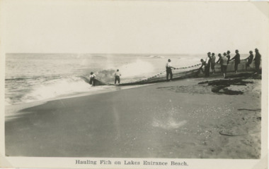 Lakes Entrance Historical Society
Postcard - Salmon Fishing Lakes Entrance, 1910 c
twelve fishermen hauling net of salmon on the beach at Lakes EntranceA black and white postcard showing twelve fishermen hauling net of salmon on the beach at Lakes EntranceHauling Fish on Lake Entrance beachfishing, fishing industry -
 Rutherglen Historical Society
Photograph - Image, 1962 (Approximate)
Lake King in Rutherglen Park is a man made lake and was the town's original reservoir for household water supplies. After the Water Tower was built, Lake King was used by the local children as a swimming pool. Since the Swimming Pool was built, Lake King has reverted to a beauty spot.Small black and white snapshot of Lake King and Pier and equipment used for Reservoir purposes - UnmountedOn back: "Lake King pre 1962 from Nokie Morrison"lake king, reservoir -
 Rutherglen Historical Society
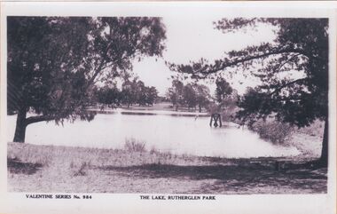
Image, c1900
"The Lake, Rutherglen Park" is now called Lake King, and was originally established as water storage for the town. The photograph is taken from the side of the lake that is currently occupied by the caravan park.One of three black and white photographs mounted on orange paper. This one is a view of Lake King.Printed at bottom of photo: "Valentine Series No. 984 The Lake, Rutherglen Park"lake king, rutherglen park -
 Lakes Entrance Historical Society
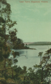
Postcard - Lake Tyers, Valentine Series 1071, 1905c
Also tinted postcard Lake Tyers Gippsland by same maker, number 03822.1 size 13.5 x 9 cm also purchased from B RocheTinted postcard of waterway surrounded by thick timber, small steamer on water. Lake Tyers VictoriaLake Tyers Gippsland Victoriaforest, waterways -
 Lakes Entrance Historical Society
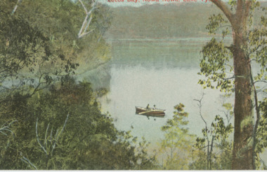
Postcard - Lake Tyers, Victoria Railways, 1905c
Also a tinted postcard titled Lake Tyers Victoria Railways Tourist Series number 03821.1 size 9 x 13.x cm purchased from B RoacheTinted postcard of Lotos Bay Nowa Nowa showing an open waterway surrounded by thick natural vegetation, rowing boat containing two people on lake. Lake Tyers VictoriaLotos Bay Nowa Nowa Lake Tyersforest, waterways -
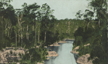 Lakes Entrance Historical Society
Postcard - Lake Tyers, E.J.B. Series, 1905c
Also a black and white postcard of Lake Tyers Gippsland number 03823.1 size 9 x 13.5 cm purchased from B RocheTinted postcard of a gorge showing a narrow waterway between rocky banks and thick vegetation near Lake Tyers VictoriaGorge near Lake Tyersforest, waterways -
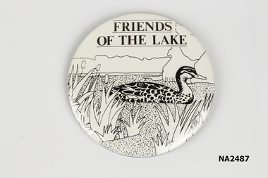 Whitehorse Historical Society Inc.
Badge, 1970 - 1980
Distributed by Friends of the LakeLarge circular white badge with black graphic of lake and duck. Pin fastening stuck with adhesive to back.On graphic 'Friends of the Lake'|imprint on back : Patrick Bros Melbourne.numismatics, badges -
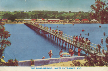 Lakes Entrance Historical Society
Photograph - Cunninghame Arm footbridge Lakes Entrance Victoria. c1955, Rose Series, 1955 c
Cunninghame Arm footbridge showing crowd on bridge, cars parked on Esplanade, new concrete wall between dunes and lake at south end of bridge Lakes Entrance Victoria. c1955. Also another colour postcard similar view of footbridge made by Murray Views donor Susan Samuel 2 January 2015 number 04272.1, 9 x 14 cmColour postcard taken from south end of the Cunninghame Arm footbridge showing crowd on bridge, cars parked on Esplanade, new concrete wall between dunes and lake at south end of bridge Lakes Entrance Victoria. c1955. Also another colour postcard similar view of footbridge The Foot-Bridge, Lakes Entrance. Vicrecreation, waterfront, land reclamation, gippsland lakes -
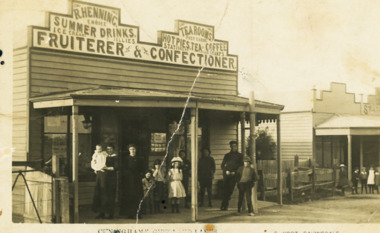 Lakes Entrance Historical Society
Postcard - Hennings Tea Room, S Vogt Bairnsdale, 1910 c
on back of card Fish 32 Francis St Bairnsdale Hennings were early Lakes Entrance familySepia toned postcard showing R Hennings Tea Rooms on Esplanade Cunninghame Group of ten adults and children outside shop with group of children outside next shop Lakes Entrance VictoriaCunninghame Gippsland Lakesbusinesses, genealogy, people -
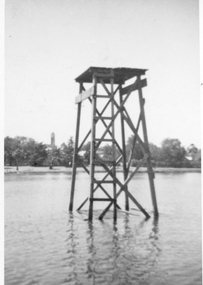 Stawell Historical Society Inc
Photograph, Cato Lake diving platform
Diving Platform Cato Lake also showing Stawell Town Hall Clock in background. The Clock Tower was added to Town Hall in 1939.Photograph of diving tower in Cato Lake. One small photo and an enlarged photo. The Stawell town hall clock can be seen in the background.Diving Tower Cato Lake Stawell.stawell -
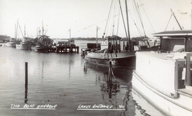 Lakes Entrance Historical Society
Photograph - Boat Harbour, 1950c
This is the before photograph used in the 150 year Lakes Entrance 1858-2008 display held in 2008.Black and white photograph of the western Boat Harbour, showing four fishing boats moored beside the jetties, also another vessel in foreground. There is a roofed shelter on each wing of the harbour. Lakes Entrance VictoriaThe Boat Harbour Lakes Entrancejetties, waterfront, boats and boating, room display -
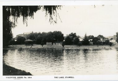 Stawell Historical Society Inc
Photograph, Cato Lake looking North Pre c 1930 -- Postcard
Post Card Valentine Series pre 1930. "The Lake" Stawell. The lake has been renamed and now called Cato Lake. This view is looking north and shows distant buildings of Stawell behind a line of trees. People can be seen enjoying the lake walking and swimming with a rotunda between the trees and the lake. Valentine Series post card of The Lake, Stawell looking north pre 1930's. The back of the Coffee Palace can be seen on the left back and the roof of the Anglican church can be seen above the trees. The other side to the right are houses in Florence Street. Along the lake are people walking and enjoying the waters edge swimming. A rotunda is to the left and the post card is framed by an overhanging willow tree. Valentine Series No 1814 The Lake, Stawell. Valentine Publishing Co. Melbourne & Sydney.stawell -
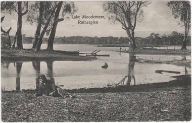 Rutherglen Historical Society
Postcard, Lake Moodemere, Rutherglen, 1900-1908
This photo is of Neddy Wheeler - Dhudhuroa man and language informant to RH Matthews. The photo was taken at Lake Moodemere. Neddy spent the latter part of his life here, especially after his Wife Charlotte and children Thomas, Harry, Dolly and Kate were taken from him in the Kiewa Valley and taken to Lake Tyers.The Aboriginal Protection Board would provide travel passes for him to visit his Country. He died in April 1908Black and white photograph, printed on postcard, showing view of Lake Moodemere, with a man wearing a jacket and hat, reclining on the bank in the foreground.Printed at top of photo: "Lake Moodemere, Rutherglen"lake moodemere, neddy wheeler, dhudhuroa, charlotte wheeler, thomas wheeler, harry wheeler, dolly wheeler, kate wheeler, kiewa valley, lake tyres, aboriginal protection board -
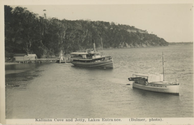 Lakes Entrance Historical Society
Postcard - S S Gippsland leaving Kalimna Jetty Lakes Entrance, H D Bulmer, 1930 c
S S Gippsland leaving Kalimna Jetty Holdens boat Sagitasse moored nearby Jemmys Point in distance Lakes Entrance VictoriaBlack and white postcard showing S S Gippsland leaving Kalimna Jetty Holdens boat Sagitasse moored nearby Jemmys Point in distance Lakes Entrance VictoriaKalimna Cove and Jetty Lakes Entranceislands, waterways, boats and boating, tourism -
 Rutherglen Historical Society
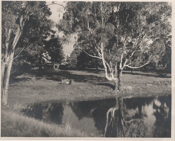
Image, Robert B Billings, c1953
Photograph of the Billings children at a picnic table at the side of Lake King.Black and white photograph of park with trees reflected on the surface of a lake. Several children are seated at a picnic table.Written on back of photo: "Rutherglen Lake. About 1953. (Stopped at [Browning?] Road)billings family, lake king, rutherglen park -
 Learmonth and District Historical Society Inc.
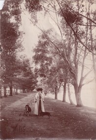
Photograph, Lily Jones with dogs by Lake Learmonth, Circa 1890's - 1910
This photo has been taken at Richmond Park, Lake Learmonth, Victoria. The woman in the photo is likely to be Lily Jones with her two dogs. The lake is to the right hand side of the photo.It is one of the many photos of the early period of Lake Learmonth and one of the inhabitants. Also the beautiful outfit that Lily Jones is wearing shows the style of day wear from the late 1800's.Sepia photo of Lily Jones with her two dogs, taken at Richmond Park, Lake Learmonth with gum trees in the background.On the back of this photo is written, Richmond Park, Lake Learmonth. Lily Jones, photo, Learmonth.lake learmonth. richmond park. lily jones. dogs. gum trees. -
 Lakes Entrance Historical Society
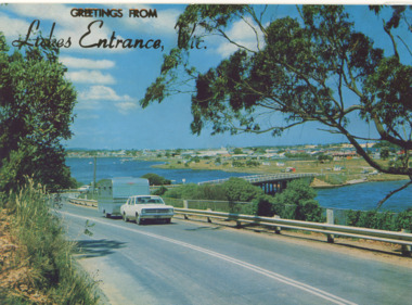
Postcard - Views of Lakes Entrance c1972, 1972 c
Princes Highway looking down to North Arm bridge with town in distance, people camped on North Arm foreshore and car towing caravan in foreground Lakes Entrance VictoriaColour postcard taken from Princes Highway looking down to North Arm bridge with town in distance, people camped on North Arm foreshore and car towing caravan in foreground Lakes Entrance VictoriaGreetings from Lakes Entrancebridges, roads and streets, township, vehicles -
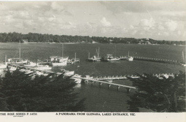 Lakes Entrance Historical Society
Postcard - Boat Harbour Lakes Entrance 1930-1971
04257.1 donated by Rick Hinde Also a colour postcard Greetings from Lakes Entrance Vic showing similar view dated 1971. with reverse side letter includedBlack and white postcard panorama from Glenara motel of western boat harbour tower showing many types of boats moored. New Works village on opposite shore of Cunninghame Arm Lakes Entrance Victoria. Also another black and white postcard entitled "The Boat Haven at Lakes Entrance with old cars in foreground. 1930 c 04257.1 10 x 15 cm donated by Rick Hinde Also a colour postcard Greetings from Lakes Entrance Vic showing similar view dated 1971. with reverse side letter includedA Panorama From Glenara Lakes Entrance Vicboats and boating, tourism, motels, correspondence -
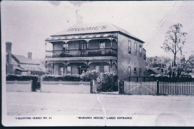 Lakes Entrance Historical Society
Photograph, Valentine Series, Maranui House, Lakes Entrance, 1920c
Lakes Entrance Prince Regent Theatre was built on block at right of Maranui in 1926Black and white photograph of Broomes Maranui House, showing a double storied timber building with balcony, sash windows, doors with fan lights and side lights. Hedge and picket fence at front. Part of Police Station visible at left, vacant block at right with picket fence. Lakes Entrance VictoriaMaranui House Lakes Entranceguesthouses, architecture, township, fences -
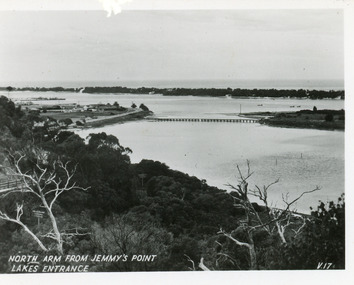 Lakes Entrance Historical Society
Postcard - North Arm, Valentine Series, 1930c
This is the before paired photograph used in the 150 year Lakes Entrance 1858-2008 display.|The after paired photograph number is 01590.1 Also one 12 x 16 framed photograph used in room display.Black and white small format postcard of North Arm and Cunninghame Arm of Gippsland Lakes, taken from Jemmys Point, Club Hotel at western end of town, bridge to Bullock Island, scrub covered hummocks and Bass Strait in distance. Lakes Entrance VictoriaNorth Arm from Jemmys Point Lakes Entrancebridges, islands, waterways, topography -
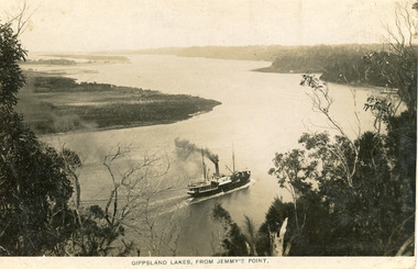 Lakes Entrance Historical Society
Postcard - SS Wyrallah, Bulmer H D, 1910
1 x enlargement 18 x 25. Donated by Stratford Historical Society with inscription Gippsland Lakes near Kalimna HotelBlack and white post card showing SS Wyrallah steaming west below Jemmy's Point, Kalimna. Rigby Island on left, looking towards Metung, tall trees on cliff in front. Lakes Entrance VictoriaGippsland Lakes from Jemmy's Pointships and shipping, waterways -
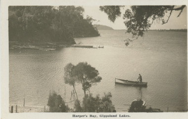 Lakes Entrance Historical Society
Postcard - Harpers Bay Gippsland Lakes, H D Bulmer, 1925 c
Harpers Bay showing the jetty where tourist launches moored for passengers to land and walk up to Mrs Westersons Cliffcrest Tea Rooms, Jemmys Point in distance Gippsland Lakes VictoriaBlack and white postcard of Harpers Bay showing the jetty where tourist launches moored for passengers to land and walk up to Mrs Westersons Cliffcrest Tea Rooms, Jemmys Point in distance Gippsland Lakes VictoriaHarpers Bay Gippsland Lakesbridges, islands, waterways, gippsland lakes -
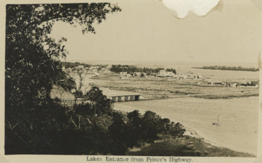 Lakes Entrance Historical Society
Postcard - First concrete bridge over North Arm Lakes Entrance Victoria, H D Bulmer, 1920 c
First concrete bridge over North Arm swamp land behind buildings on Esplanade low sand dunes on outer barrier Lakes Entrance VictoriaBlack and white postcard of township showing first concrete bridge over North Arm swamp land behind buildings on Esplanade low sand dunes on outer barrier Lakes Entrance VictoriaLakes Entrance from Princes Highwayislands, roads and streets, bridges, township -
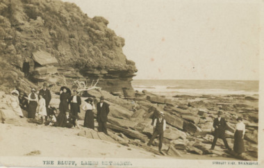 Lakes Entrance Historical Society
Postcard - Red Bluff 1910 c, Stanley Vogt, 1910c
Paired with image 03731.1 for display in 150 years Lakes Entrance 1858 to 2008 held in October 2008Sepia toned postcard west side of Red Bluff showing a group of eight men and five women and a child. Sand washed away exposing vast rocky beach, short vegetation on rocky bluff. Women wearing full length skirts and wide brim hats with veils, men in three piece suits dark in colour on ninety mile beach Lake Tyers VictoriaThe Bluff Lakes Entrancetopography, fashion -
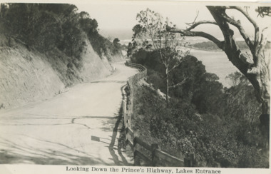 Lakes Entrance Historical Society
Postcard - Princes Highway Lakes Entrance, 1930 c
Princes Highway Jemmys Point showing gravel road post and rail fence freshly excavated cliff with Entrance glimpses in distance Lakes Entrance Victoria. Also a second black and white postcard taken much later of Princes Highway Jemmys Point Lakes Entrance showing sealed road with double lines in centre, post and rail fence, Entrance in distance. Donor Susan Samuel 2 January 2015. Number 04204.1Black and white postcard taken of Princes Highway Jemmys Point showing gravel road post and rail fence freshly excavated cliff with Entrance glimpses in distance Lakes Entrance VictoriaLooking Down the Princes Highway Lakes Entrancecivil engineering, roads and streets, fences -
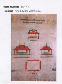 Friends of Ballarat Botanical Gardens History Group
Work on paper - King Edward V11 Pavilion, On the shores of Lake Wendouree, Ballarat
... On the shores of Lake Wendouree, Ballarat. ...john garner collection, ballarat botanical gardens, gardens, ballarat, king edward, pavilion, lake wendouree