Showing 107 items
matching reef lines
-
 Bendigo Historical Society Inc.
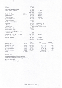
Document - NEW CHUM & VICTORIA LINES OF REEF - PRODUCTION OF GOLD (OUNCES)
... NEW CHUM & VICTORIA LINES OF REEF - PRODUCTION OF GOLD...New Chum & Victoria Lines of Reef...DOCUMENT Gold New Chum & Victoria Lines of Reef Production ...Handwritten notes with production of gold from some of the mines. Some have the number of ounces per ton and the average per ton of ore. Mines mentioned are Lazarus, Old Chum 7 Early Grou?, New Chum & Victoria, North Old Chum, Lansell's 180, Victoria Quartz, Gt Central Victoria, Victoria Colsols, South Adventure Group, Adventure, Advance, Try - Me - Well, Prince Alfred, Alfred Co, Ironbark Co, Herc & Energetic.document, gold, new chum & victoria lines of reef, production of gold (ounces), lazarus, new chum & victoria, north old chum, lansell's 180, victoria quartz, gt central victoria, victoria consols, sou;th adventure group, adventure, advance, try - me - well, prince alfred, j r evans, ironbark co, herc & energetic -
 Bendigo Historical Society Inc.
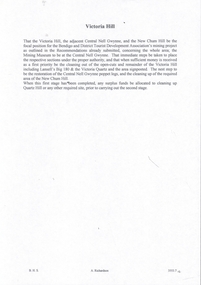
Document - NEW CHUM & VICTORIA LINES OF REEF - NOTES ON VICTORIA HILL FOR TOURIST ATTRACTION
... NEW CHUM & VICTORIA LINES OF REEF - NOTES ON VICTORIA HILL...New Chum & Victoria Lines of Reef...DOCUMENT Gold New Chum & Victoria Lines of Reef Central ...Handwritten notes outlining a plan for Victoria Hill, Central Nell Gwynne and New Chum Hill to be the focal position for a tourist attraction. Outlines steps to be taken to do the work and a mining museum at the Central Nell Gwynne. On the back of the page is a sketch of Victoria & New Chum Hills. On the plan is the Battery, Rae, Rae's House, Rae's Open Cut, Wittscheibe, Midway, Victoria Quartz, Lansell's 180 Shaft and the Recreation Reserve.document, gold, new chum & victoria lines of reef, central nell gwynne, new chum hill, bendigo and district tourist development association, victoria hill, lansell's big 180, victoria quartz, rae's open cut -
 Bendigo Historical Society Inc.
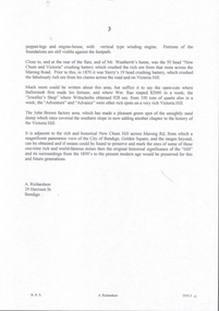
Document - NEW CHUM & VICTORIA LINES OF REEF - NOTES ON VICTORIA HILL
... NEW CHUM & VICTORIA LINES OF REEF - NOTES ON VICTORIA HILL...New Chum & Victoria Lines of Reef...DOCUMENT Gold New Chum & Victoria Lines of Reef Notes ...Handwritten notes describing where the crushing battery was at Victoria Hill. Mentions Wallerstedt's open cut mine. John Brown factory built on the sand dumps. Mentions the views from the Hill of the City of Bendigo, Golden Square and the ranges beyond. Note written by A Richardson.document, gold, new chum & victoria lines of reef, notes on victoria hill, mr weatheritt, new chum & victoria crushing battery, victoria hill, ballerstadt, wittscheibe, john brown factory, a richardson -
 Bendigo Historical Society Inc.
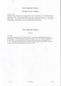
Document - NEW CHUM & VICTORIA LINES OF REEF - NEW CHUM & VICTORIA MINE MANAGER'S REPORTS
... NEW CHUM & VICTORIA LINES OF REEF - NEW CHUM & VICTORIA...New Chum & Victoria Lines of Reef...DOCUMENT Gold New Chum & Victoria Lines of Reef New Chum ...Handwritten copies of four Mine Manager's reports for the New Chum & Victoria dated 13/12/1879, Manager Wm H Grainger, 13/3/1884, Manager W. H. G., 15/3/1886, and 21 /6/1886. Reports mention equipment, costs, and a new Winding Plant where they hauled water before allowing the men to descend. Notes on testing boilers.document, gold, new chum & victoria lines of reef, new chum & victoria mine manager's reports, wm h grainger -
 Bendigo Historical Society Inc.
Document - NEW CHUM AND VICTORIA LINES OF REEF - NOTES ON NEW CHUM & VICTORIA
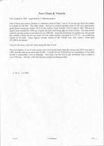
... NEW CHUM AND VICTORIA LINES OF REEF - NOTES ON NEW CHUM...new chum & victoria lines of reef...DOCUMENT Gold new chum & victoria lines of reef New Chum ...Two handwritten pages of notes on the New Chum & Victoria, first worked in 1854. Notes give information on yields, where good yields were found, dividends and profits. Written at the top of page: A. M. S. 1/6/1899.document, gold, new chum & victoria lines of reef, new chum and victoria lines of reef, notes on new chum & victoria, hudson's claim, burrow's claim -
 Bendigo Historical Society Inc.
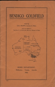
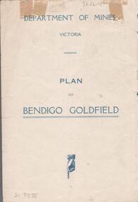
Book - BENDIGO GOLDFIELD
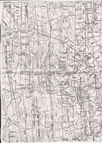
... on the geology of the Bendigo goldfield and major lines of reef... goldfield and major lines of reef and mines. Map of goldfield ...booklet, 51 pages. 'Bendigo Goldfield' issued by Geo Brown, Secretary for Mines. Mines Department 1936. Contains information on the geology of the Bendigo goldfield and major lines of reef and mines. Map of goldfield showing reef lines and mines attached to back cover.bendigo, mining, bendigo goldfield -
 Bendigo Historical Society Inc.
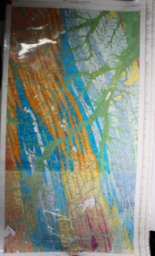
Map - BENDIGO GOLDFIELDS MAP
... Map of the Bendigo Goldfield, showing reef lines, mines..., showing reef lines, mines and significant geographical features ...Map of the Bendigo Goldfield, showing reef lines, mines and significant geographical features such as Monument Hill, Quartz Hill and Diamond Hill. On the back of map 'Department of Mines, Victoria. Plan of Bendigo Goldfield.bendigo, mining, bendigo goldfields -
 Bendigo Historical Society Inc.
Map - GEOLOGICAL MAP OF BENDIGO GOLD FIELD
... lines, map (b) is a continuation of the reef lines in map... laminated maps (a,b) of Bendigo goldfield reef lines, map (b ...Two framed laminated maps (a,b) of Bendigo goldfield reef lines, map (b) is a continuation of the reef lines in map (a). On map(a) written in black on top: 'Geological Map, Bendigo Gold Field', Scale of chains, anticlines, synclines, shafts, alluvial and contours marked. Map (b) is continuation of (a). Written on the bottom RH corner of map: 'Prepared in 1923 in the Bendigo Office Mines Department under the direction of H. Herman, Director of Geological Surveys, from surveys by H.S. Whitelaw, Fiield Geologist, assisted by E.S. Usher & J. J. Moore. Re-issued in 1936.'H. Herman, Director of Geological Surveys, from surveys by H.S. Whitelaw, Fiield Geologist, assisted by E.S. Usher & J. J. Moore. Re-issued in 1936.'bendigo, mining, geological map. -
 Bendigo Historical Society Inc.
Map - Geological survey of Bendigo Goldfields
... and Spring Gully. It shows geological conditions, gold reef lines... geological conditions, gold reef lines and mine sights. Three ...Three Geological survey maps of the Bendigo Gold Fields joined together. The three sections are Eaglehawk, Golden Square and Spring Gully. It shows geological conditions, gold reef lines and mine sights. Three sections are laminated together. The maps were produced by the Victorian Department of Manufacturing and Industry Development geological survey, bendigo gold fields -
 Bendigo Historical Society Inc.
Document - CONSTABLE RYAN COLLECTION: LINES OF REEFS OF BENDIGO FIELD
... Photocopy of a map showing the lines of reefs of Bendigo... Bendigo goldfields Photocopy of a map showing the lines of reefs ...Photocopy of a map showing the lines of reefs of Bendigo goldfields.map, bendigo, goldfields -
Bendigo Historical Society Inc.
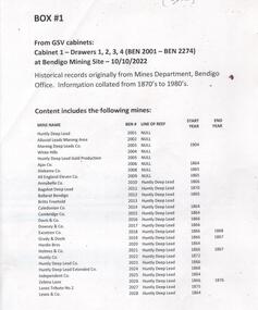
Document - MINING WARDEN COLLECTION: BENDIGO HISTORICAL MINING RECORDS
... is enclosed in a manilla folder within the box. Reef lines listed...#, the line of reef located on, the start and end year. Individual ...Historical records originally from the Mining Warden's Office, Mines Department, Bendigo. Information collated from 1870's to 1980's. A summary document lists the BEN# from 3311 to 3440 and describes the mine name; the BEN#, the line of reef located on, the start and end year. Individual mine data is enclosed in a manilla folder within the box. Reef lines listed are: New Chum Nell Gwynne Sample entry: Ballerstedt, #3326, New Chum line of reef, 1853 to 1871.bendigo, mining, mining warden records -
Bendigo Historical Society Inc.
Document - MINING WARDEN COLLECTION: BENDIGO HISTORICAL MINING RECORDS
... is enclosed in a manilla folder within the box. Reef lines listed...#, the line of reef located on, the start and end year. Individual ...Historical records originally from the Mining Warden's Office, Mines Department, Bendigo. Information collated from 1870's to 1980's. A summary document lists the BEN# from 3151 to 3310 and describes the mine name; the BEN#, the line of reef located on, the start and end year. Individual mine data is enclosed in a manilla folder within the box. Reef lines listed are: New Chum Napoleon Sample entry: Adventure and Advance, #3162, New Chum line of reef, 1871 to 1880.bendigo, mining, mining warden records -
Bendigo Historical Society Inc.
Document - MINING WARDEN COLLECTION: BENDIGO HISTORICAL MINING RECORDS
... . Reef lines listed are: Garden Gully and Deborah. Example... within the box. Reef lines listed are: Garden Gully and Deborah ...Historical mining records originally from the Mining Warden's Office, Mines Department, Bendigo. Information collated from 1870's to 1980's. A summary document lists the BEN# from 2801 to 2955 and describes the mine name; the BEN#, the line of reef located on, the start and end year. Individual mine data is enclosed in a manilla folder within the box. Reef lines listed are: Garden Gully and Deborah. Example of entry: Knee Tributor Co. BEN # 2823, Garden Gully reef, 1870. (no end date given).bendigo, mining, mining warden records -
Bendigo Historical Society Inc.
Document - MINING WARDEN COLLECTION: BENDIGO HISTORICAL MINING RECORDS
... in a manilla folder within the box. Reef lines listed are: Deborah... is enclosed in a manilla folder within the box. Reef lines listed ...Historical records originally from the Mining Warden's Office, Mines Department, Bendigo. Information collated from 1870's to 1980's. A summary document lists the BEN# from 2596 to 3025 and describes the mine name; the BEN#, the line of reef located on, the start and end year. Mine data is enclosed in a manilla folder within the box. Reef lines listed are: Deborah and Sheepshead Sample entry: Irish and Scotch, #2974, Deborah line of reef, start year 1867, end year 1879.bendigo, mining, mining warden records -
Bendigo Historical Society Inc.
Document - MINING WARDEN COLLECTION: BENDIGO HISTORICAL MINING RECORDS
... in a manilla folder within the box. Reef lines listed are: Paddy's... is enclosed in a manilla folder within the box. Reef lines listed ...Historical records originally from the Mining Warden's Office, Mines Department, Bendigo. Information collated from 1870's to 1980's. A summary document lists the BEN# from 2585 to 2800 and describes the mine name; the BEN#, the line of reef located on, the start and end year. Mine data is enclosed in a manilla folder within the box. Reef lines listed are: Paddy's Gully Derby Paddy's Gully/Garden Gully Example of entry: Meridien Quartz Mining Co. 2595, Paddy's/Garden Gully, 1876-1877.bendigo, mining, mining warden records -
Bendigo Historical Society Inc.
Document - MINING WARDEN COLLECTION: BENDIGO HISTORICAL MINING RECORDS
... is enclosed in a manilla folder within the box. Reef lines listed... is enclosed in a manilla folder within the box. Reef lines listed ...Historical records originally from the Mining Warden's Office, Mines Department, Bendigo. Information collated from 1870's to 1980's. A summary document lists the BEN# from 3407 to 3532 and describes the mine name; the BEN#, the line of reef located on, the start and end year. Individual mine data is enclosed in a manilla folder within the box. Reef lines listed are: Nell Gwynne British and Foreign Napoleon Sample entry: Combes, 3445.01, British and Foreign reef line, 1888 to 1889.bendigo, mining, mining warden records, nell gwynne, british and foreign, napoleon -
Bendigo Historical Society Inc.
Document - MINING WARDEN COLLECTION: BENDIGO HISTORICAL MINING RECORDS
... is enclosed in a manilla folder within the box. Reef lines listed...#, the line of reef located on, the start and end year. Individual ...Historical records originally from the Mining Warden's Office, Mines Department, Bendigo. Information collated from 1870's to 1980's. A summary document lists the BEN# from 2599 to 4093 and describes the mine name; the BEN#, the line of reef located on, the start and end year. Individual mine data is enclosed in a manilla folder within the box. Reef lines listed are: Garden Gully Birds Sample entry: Great Southern Extended (Yankee shaft) #2616Garden Gully line of reef, 1904 - 1908.bendigo, mining, mining warden records -
Bendigo Historical Society Inc.
Document - MINING WARDEN COLLECTION: BENDIGO HISTORICAL MINING RECORDS
... is enclosed in a manilla folder within the box. Reef lines listed...#, the line of reef located on, the start and end year. Individual ...Historical records originally from the Mining Warden's Office, Mines Department, Bendigo. Information collated from 1870's to 1980's. A summary document lists the BEN# from 3533 to 3745 and describes the mine name; the BEN#, the line of reef located on, the start and end year. Individual mine data is enclosed in a manilla folder within the box. Reef lines listed are: Lancashire Carsharlton Derby Thistle Millers Derby Sample entry: Jersey Reef Claims, #3546, Lancashire line of reef, 1865 to 1882,bendigo, mining, mining warden records -
 Bendigo Historical Society Inc.
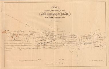
Document - MARKS COLLECTION: ABE LINCOLN CO LEASE
... Vue Reef, New Chum Reef, Black Lead, Victoria Reef lines shown... Reef lines shown on map with mine leases marked. On bottom ...Two copies of plan for Abe Lincoln Co. Lease, New Chum, Sandhurst. One original, one copy. On top of plan 'Plan Showing Position of the Abe Lincoln Co. Lease, New Chum, Sandhurst' under name 'by H.B. Nicholas, Mining Surveyor' Sheepshead Reef, Easter reef, Alfred Reef, Allingham Reef,Adventure Reef, Belle Vue Reef, New Chum Reef, Black Lead, Victoria Reef lines shown on map with mine leases marked. On bottom of map 'Monument Hill Reef' line marked.bendigo, mining, abe lincoln lease -
Bendigo Historical Society Inc.
Document - MINING WARDEN COLLECTION: BENDIGO HISTORICAL MINING RECORDS
... is enclosed in a manilla folder within the box. Reef lines listed...BENDIGO Mining mining warden records Sheepshead Reef New ...Historical records originally from the Mining Warden's Office, Mines Department, Bendigo. Information collated from 1870's to 1980's. A summary document lists the BEN# from 3026 to 3150 and describes the mine name; the BEN#, the line of reef located on, the start and end year. Individual mine data is enclosed in a manilla folder within the box. Reef lines listed are: Sheepshead New Chum New Chum/Thistle Sample entry: Polkinhorne and Palk, #3069, New chum line of reef, start date 1870, end date 1875.bendigo, mining, mining warden records, sheepshead reef, new chum reef, thistle reef -
 Bendigo Historical Society Inc.
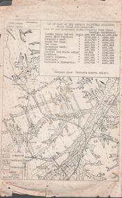
Document - MINING REPORTS - MAP OF PART OF THE BENDIGO GOLDFIELD INCLUDING WHITE HILLS AND EAGLEHAWK
... and Eaglehawk. Map shows reef lines, gullies, railway line, tram route... Goldfield including White Hills and Eaglehawk. Map shows reef lines ...BHS CollectionMap of part of the Bendigo Goldfield including White Hills and Eaglehawk. Map shows reef lines, gullies, railway line, tram route, type of rock, name of mine, Calls and Dividends. Also Deepest Mine Victoria Quartz 4614 ft. Names of Mines are Garden Gully United, Great Ext'd Hustlers, Johnson's Reef, South New Moon, New Moon, Catherine Reef, Virginia, Central Red White & Blue, Ironbark, Kock's Pioneer, Carlisle and the Hercules & Energetic. Map is part of the Albert Richardson Collection of mining documents and research. document, gold, mining reports, mining reports, map of part of the bendigo goldfield including white hills and eaglehawk, pabst bendigo goldfield, garden gully united, great ext'd hustlers, johnson's reef, south new moon, new moon, catherine reef, virginia, central red white & blue, ironbark, kock's pioneer, carlisle, hercules & energetic. victoria quartz -
 Bendigo Historical Society Inc.
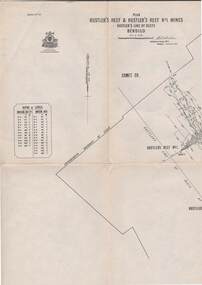
Map - STRUGNELL COLLECTION: HUSTLER'S LINE OF REEF, September 1913
... No 33 Signed H.A.Whitelaw. Drawing shows reef boundary lines... Bendigo hustler's reef & hustler's reef 1 Underground Survey ...Map, Hustler's Line of Reefs, Hustler's Reef & Hustler's Reef No.1 Mines Bendigo.Plate No. X1V (14) Comet Co. .Bulletin No 33 Signed H.A.Whitelaw. Drawing shows reef boundary lines .There is an explanatory box showing depth in feet and inches of the mines .Underground Survey Office, Bendigo.map, bendigo, hustler's reef & hustler's reef 1 -
Bendigo Historical Society Inc.
Document - MINING WARDEN COLLECTION: BENDIGO HISTORICAL MINING RECORDS
... is enclosed in a manilla folder within the box. Reef lines listed...#, the line of reef located on, the start and end year. Individual ...Historical records originally from the Mining Warden's Office, Mines Department, Bendigo. Information collated from 1870's to 1980's. A summary document lists the BEN# from 3754 to 4080 and describes the mine name; the BEN#, the line of reef located on, the start and end year. Individual mine data is enclosed in a manilla folder within the box. Reef lines listed are: Derby Christmas Garden Gully Gravel Hill Thistle Carshalton Myers Flat Birds Hit or Miss Break of Day Crusoe Big Hill line Sample entry: Brilliant Co., BEN# 3757, Garden Gully line of reef, 1870 - 1880.bendigo, mining, mining warden records -
 Bendigo Historical Society Inc.
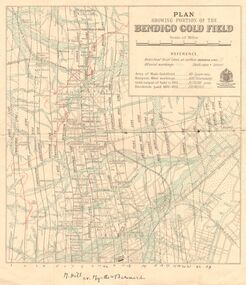
Map - DEPARTMENT OF MINES VICTORIA : PLAN SHOWING PORTION OF THE BENDIGO GOLD FIELD
... cr. Myrtle & Barnard' .The named reef lines have been... cr. Myrtle & Barnard' .The named reef lines have been ...Department of Mines Victoria. Plan showing portion of the Bendigo Gold Field. On the back is written, in ink, J. J. Tyler 1937 Northern Area. (He was a teacher at Bendigo High - see donation notes). Across the bottom of the map is written ' M. Hill cr. Myrtle & Barnard' .The named reef lines have been numbered with ink across the bottom of the map. The gullies have been coloured with green pencil and a red pencil line is drawn through the western side of the map. Additional information: anticlinal axial lines at surface, alluvial workings, shaft sites, area of Main Goldfield, Deepest mine workings, Gold output of field to 1935, and Dividends paid 1870 - 1935.bendigo, gold mining, bendigo gold field. gold mining. tyler, j. j. -
 Bendigo Historical Society Inc.
Document - MINING WARDEN COLLECTION
... . Mines along the following reef lines are described: Huntly Deep... #; the line of reef located on, the start and end year. Information ...Historical mining records originally from the Mining Warden's Office, Mines Department, Bendigo. A summary document lists the mine name; the BEN #; the line of reef located on, the start and end year. Information collated from 1870's to 1980's. Each mine's data is enclosed in a manilla folder within the box. Mines along the following reef lines are described: Huntly Deep Lead Whipstick Neilborough Drover Isabella Slaughteryard Blue Jacket Tyson One Tree Hill Flag Gravel Hill View Hill Lightning Hill Hustlers Ben # range from 2001 to 2274. Example of entry: Pascoe and Symmonds, Ben # 2217, Lightning Hill Reef, 1863-1885.bendigo, mining, mining warden records -
Bendigo Historical Society Inc.
Map - SECTIONS ACROSS BENDIGO GOLDFIELD
... zones and mines along the reef lines. Key shows rock types... zones and mines along the reef lines. Key shows rock types ...Map in three sections showing sections across Bendigo Gold Field, showing anticlines, synclines, faults, stratigraphical zones and mines along the reef lines. Key shows rock types Castlemaine, Bendigo B1, B2, B3 and B4, and Lancefieldian. First part of map shows sections A-A, B-B and C-C. Reef lines drawn with mines listed: Fault line shown are the Carshalton, Stafford, New Chum, Virginia and Clarence. A datum line shows 600 ft above sea level. On bottom of plan: ' Prepared in the Geological Survey Office, Bendigo, under the direction of H. Herman, late Director of Geological Survey, from surveys by H.S. Whitelaw, Field Geologist, assisted by E.S. Usher, A.J.J. Moore and R.A. Keble.' Second section of map shows sections D-D, and E-E. Fault lines listed are the Tambour Major fault, Carshalton fault, Stafford fault, Nell Gwynne fault, New Chum fault, Deborah fault. Third section shows sections F-F and G-G. Fault lines listed are the Bird Reef fault, Kangaroo Gully fault, Langdon fault, Carshalton fault, Nell Gwynne fault, Spring Gully fault, Hustlers fault, Gravel Hill fault, Ordes fault, Thanet fault. This map forms part of the Geological Survey of Victoria, Structure of Bendigo Goldfield report, No. 47, 1923. H.Herman, late Director of Geological Survey.Geological Survey of Victoriabendigo, gold mining, reef line maps -
Bendigo Historical Society Inc.
Document - MINING IN BENDIGO COLLECTION: NOTES ON MINING IN BENDIGO
... the size of the Bendigo Goldfield, the number of lines of reef... mention the size of the Bendigo Goldfield, the number of lines ...Handwritten notes on mining in Bendigo. Notes mention the size of the Bendigo Goldfield, the number of lines of reef and a brief history of goldmining in Bendigo.document, gold, mining in bendigo, mining in bendigo, notes on mining in bendigo, ravenswood sheep run, survey regiment, california hill state school, lansell's 222, mr lansell, camp hill school, high school, park mine (royal hustler's reserve no 1), memorial hall, city mine ( royal hustlers reserve no 2), mining stock exchange, beehive buildings, allan's walk, buckell & jeffrey, fortuna hustlers, great extended huatlers, garden gully united, mining exchange, garden gully united, wattle gully mine, ironbark mine, manchester arms hotel, extended hustlers mine, south belle vue, new chum railway, eureka extended, shenandoah, victoria quartz, the big 180, old chum, gt extended hustlers -
 Bendigo Historical Society Inc.
Document - ALBERT RICHARDSON COLLECTION: VICTORIA REEF, TRY ME WELL REEF AND HERCULES REEF
... , 1861. Document details the location of the reef lines and some... details the location of the reef lines and some of the mines ...Three page handwritten document transcribed by Albert Richardson. On top of document: The Victoria Reef, Victoria Spurs, East Victoria Reef, Try McWell Reef and the Hercules Reef. Reference Dickers Mining Record, Vol 1, No. 1 Page g. November 23, 1861. Document details the location of the reef lines and some of the mines and claims along them. For example, page one: 'The main Victoria, really a continuation of the South Victoria, commences at a point to the west of the Mt Korong Road, where the high portion of the ranges is intersected by the head of the Iron Bark Gully, the southern most claim being Ballerstedt and Son's. This line of reef is remarkable from the extraordinary richness of the lodes, not less than from the singular manner in which the gold has been distributed'.Albert Richardsonbendigo, mining, victoria reef line -
Bendigo Historical Society Inc.
Map - GEOLOGICAL MAP: BENDIGO GOLD FIELDS
... display , reef lines, Hills, Dams and mine locations. Also... of the Bendigo Gold fields. The maps display , reef lines, Hills, Dams ...GEOLOGICAL MAP - BENDIGO GOLD FIELDS - Donated by JOHN HORWOOD. Two geological maps of the Bendigo Gold fields. The maps display , reef lines, Hills, Dams and mine locations. Also Anticlines, sinclines, shafts, alluvial deposits, contours and gullys. All items are superimposed on a map of the major roads and streets of Bendigo. The maps were printed by The Victorian Minister for Mines in 1923 and re-issued in 1936. The maps have been specifically framed and donated to The Bendigo Historical Society Inc. in May 2015 for display at Specimen Cottage. John had been a student at The School of Mines- Bendigo and found them useful as a student living in Bendigo. Prior to being framed , the maps have been kept rolled up in his home. Accession Number 309/15 Were on Display at Specimen Cottage 2015 - 2020. After all items removed from SC to the BRAC in 2021 the framed maps could not be located. Search ongoing. BP 2.3.2023Victorian Minister of Minesgoldfields -
 Bendigo Historical Society Inc.
Document - ALBERT RICHARDSON COLLECTION: SECRETARY FOR MINES ANNUAL REPORT 1911
... in a diagram' (diagram not included with notes) Mines and reef lines... sections along the lines of reefs or anticlines within the 8 mile ...Three page typed report titled ' Notes on diagram showing pitch lines, Bendigo'. Longitudinal sections along the lines of reefs or anticlines within the 8 mile block at Bendigo are shown in a diagram' (diagram not included with notes) Mines and reef lines mentioned in the report are : New Chum line, New Chum Railway mine, Catherine United mine, Hercules and Energetic mine, Garden Gully, Hustlers and Redan, Sheepshead Reef, Sea Mine, Garden Gully, Miller's line of reef and Bendigo Development Mine. The 'old stacks' or chimneys, on Bendigo are described. 'Among the earliest of the stacks built at Bendigo in connexion with Quartz crushing plant, are the two figured in this Annual report No 1 was situate in Sailor's Gully but was demolished about three years ago. This, if not the first, must have been one of the first built, for it had a stone inserted on which chiselled the date 1854. It was built altogether of rough masonry. The other, No. 2, is still standing at the Sheepshead line and was apparently of later date, the upper portion being of brick. They are intersting landmarks of an era that is rapidly passing.' Map attached to report showing location of stacks. Stack at Sailors Gully was near the corner of Murchison Street and Lester Street. The stack at Sheepshead ( Deborah Triangle area) was near the intersection of Belle Vue Road and Adam Street.bendigo, mining, pitch lines bendigo