Showing 107 items
matching shoreline
-
 Lakes Entrance Historical Society
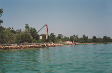
Photograph - Old crane and Snapper Cottage Lakes Entrance Victoria c2010, M Holding, 2010 c
Colour photograph showing old crane and Snapper Cottage on the Western side of the Entrance, shoreline stabilised with rock ouside the original walings which edged the lakes, Lakes Entrance Victoriaships and shipping, transport, waterways, gippsland lakes -
 Phillip Island and District Historical Society Inc.
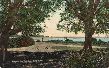
Photograph - Post Card, Valentine Postcard
Postcard donated by Mrs D Motton given to Kevin Findlay, Lang Lang.Coloured postcard taken from San Remo looking across to Newhaven, Phillip Island. Photograph showing two trees either side with lady in long dress and umbrella near the shoreline.Newhaven from San Remo, Phillip Island.views newhaven, newhaven phillip island, coastal views, mrs d motton, kevin findlay -
 Lakes Entrance Historical Society
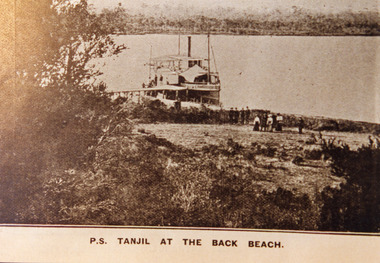
Photograph - P.S. Tanjil, 1910 c
Sepia photograph of postcard showing P S Tanjil at the back beach. People near shoreline, vegetation on dunes, western end of Boole Poole peninsula in background. Gippsland Lakes, VictoriaP S Tanjil at the Back Beachships and shipping, waterways, beaches -
 Lakes Entrance Historical Society
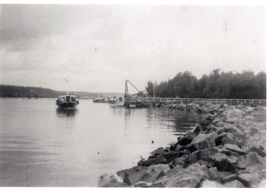
Photograph - Blackbird, 1940c
Black and white photograph showing rock retaining wall along shoreline west of entrance, crane on jetty, several boats including Peels Blackbird just off jetty at Lakes Entrance, Victoria. waterways, boats and boating, tourism -
 Lakes Entrance Historical Society
Photograph - Carpentertown, 1920c
Copied from copy in J Whadcoat collectionBlack and white photograph showing P W D cottage on left and other Works buildings on dune at the entrance to Gippsland Lakes from the ocean - Bass Strait. View shows flagstaff on top of dune and flagstaff jetty in lake - Cunninghame Arm. Small sailing boat on left and other small craft on shoreline. Section of Bullock Island with vegetation, one telegraph pole and one dead tree on island. Shoreline of North arm in foreground. Lakes Entrance Victoriajetties, waterways, settlement, historic site, boats and boating -
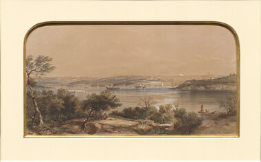 Benalla Art Gallery
Print, Conrad MARTENS, View of Sydney. NSW, 1855
Born: London, England 1801; Arrived: Sydney, New South Wales, Australia 1835; Died: Sydney, New South Wales, Australia 1878ColonialBennett Bequest, 1999 Hand-coloured lithograph depicting industrial waterscape with rocky shoreline and ships and buildings in background. Black painted timber frame with off white arched window mount and gold brushed internal window edgeRecto: Not signed, not dated, not titled print, waterscape, sea, harbour, land, figures, boats, tress, sydney harbour, buildings -
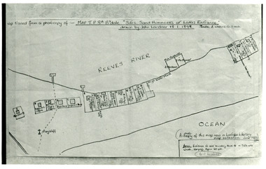 Lakes Entrance Historical Society
Photograph - New Works Plan, 1898
Map traced from a photocopy of :- Map TP8A Bairnsdale. 'Site. Sand Hummocks of Lakes Entrance'. Drawn by John Lardner 18 January 1898. Scale two chains to one inch. ( A photocopy of this map in Latrobe Library map collection, June 1983)Black and white photograph showing sketch map of 1898 by John Lardner Plan of Sites - sand hummocks. Drawing shows sites of buildings at entrance along Cunninghame Arm shoreline at Lakes Entrance, Victoria.land settlement, plan -
 Lakes Entrance Historical Society
Postcard - The Narrows, 1930c
Black and white small format postcard of a steamer in the Narrows, Rigby Island opposite the steep shoreline of the mainland, Reeve's Channel, Fraser Island and Flannagan Island in distance, Gippsland Lakes, Lakes Entrance Victoria.islands, waterways, topography -
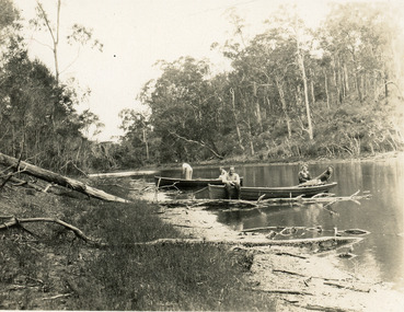 Lakes Entrance Historical Society
Photograph - North Arm, 1950c
Black and white photograph of the narrow upper reaches of the North Arm. It shows four people and dog at two small boats on bank. Steep tree covered hillsides above sandy shoreline. Lakes Entrance Victoria vegetation, waterways, recreation -
 Lakes Entrance Historical Society
Photograph - Reeves Channel, Fraser, Ian, 1995c
Colour photograph of Reeves Channel of Lake King, Gippsland Lakes. It shows part of both Rigby Island and Fraser Island opposite the steep shoreline of the mainland. Two motor boats on lake. Lakes Entrance Victoriaislands, waterways, topography -
 Lakes Entrance Historical Society
Photograph - Rubeena, 1920 c
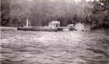
Also a black and white photograph showing S S Gippsland across the lake 05253.1 11.5 x 7 cmBlack and white photograph of two Lakes passenger vessels Rubeena 2 and Rubeena 1 taken in Cunninghame Arm with The Beacons just visible across the lake, boatshed on shoreline across lake Lakes Entrance Victoriaboats and boating, tourism -
 Lake Bolac & District Historical Society
Black and white photograph, "Lake Boloke" homestead and the dry shore-line of Lake Bolac, circa 1855
A very early view of the first blue-stone homestead and out-buildings at "Lake Boloke" station, established by Robert Patterson, believed taken in the early 1850's. The row of River red-gums indicates the shoreline of Lake Bolac which seems to be at least partially dry.lake bolac, lake boloke station, patterson -
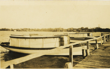
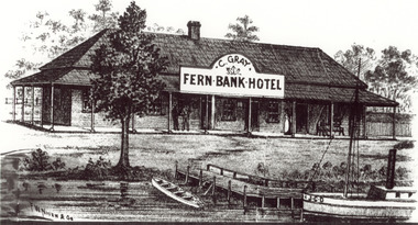 Lakes Entrance Historical Society
Photograph - Sketch of Fernbank Hotel, 1885c
Fernbank Hotel built 1885, this drawing appears to be an advertisement for the hotel. Fernbank Hotel Catherine Gray Proprietor CunninghameBlack and white photograph of a sketch of Fernbank Hotel, showing small timber building, veranda on front and side, timber jetty at edge of lake, rowing boat at shoreline, steamer with letters JCD on bow. Lakes Entrance Victoriaguesthouses, waterfront, tourism, boats and boating -
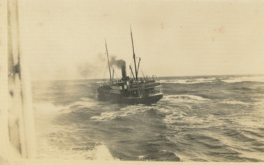 Lakes Entrance Historical Society
Postcard - SS Wyrallah c1920, 1920 c
Black and white photograph showing SS Wyrallah steaming out to sea after leaving harbour, surf beach breaking against low shoreline in distance taken from another boat off Lakes Entrance Victoria the entrance, boats and boating, steamers, waterways, gippsland lakes -
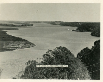 Lakes Entrance Historical Society
Postcard - Reeves Channel, Valentine Series, 1930c
Other copy similar view with inscription 'The Lakes, Lakes Entrance Vic'Black and white postcard of Reeves Channel Gippsland Lakes, showing Rigby, Fraser and Flannagan Islands opposite the steep shoreline of the mainland. Natural vegetation of Jemmys Point in foreground from which photograph was taken. Lakes Entrance VictoriaKalimna from Jemmys Point Lakes Entranceislands, waterways, topography -
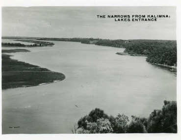 Lakes Entrance Historical Society
Postcard - The Narrows, Bulmer H D, 1945c
Also two other copies 6.5 x 8.5Black and white small format postcard of the Narrows, and Reeves Channel of Lake King, Gippsland Lakes, showing Rigby, Fraser and Flannagan Islands opposite the steep shoreline of the mainland. Taken from Jemmys Point. Lakes Entrance VictoriaThe Narrows from Kalimna Lakes Entranceislands, waterways -
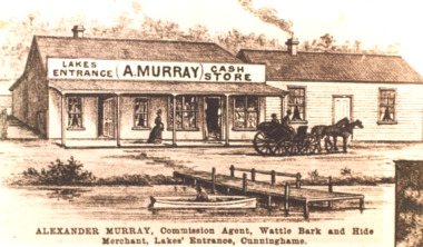 Lakes Entrance Historical Society
Photograph, A Murrays cash store on Esplanade, Lakes Entrance Victoria, 1895
This is one of Lakes Entrances oldest buildings, Alexander Murray built KiaOra House on this site in 1899 Sepia toned copy of postcard showing impression of A Murrays cash store on Esplanade, drawing shows buggy and pair of horses in front of store, woman in long gown on footpath, jetty and row boat on shoreline Lakes Entrance VictoriaAlexander Murray Commission Agent Wattle Bark and Hide Merchant Lakes Entrance Cunninghamebusinesses, vehicles, animals, jetties -
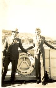 Federation University Historical Collection
Photograph, Black and White, 13.2.1940
Frank Wright was a renown resident of Smeaton, where he was born. He lived at Laura Villa, and attended Smeaton State School. His father William was a gold miner and his mother's name was Sarah. Their family won many singing and instrumental awards. Frank was tutored by Percy Code and was awarded a gold medal for the highest marks in the ALCM examinations in the British Colonies at the age of seventeen years. He became the Australian Open Cornet Champion by the age of eighteen. A year later, Frank conducted the City of Ballarat Band, and later the Ballarat Soldiers’ Memorial Band. He formed the Frank Wright Frisco Band and Frank Wright and his Coliseum Orchestra. These bands won many South Street awards, and Frank as conductor won many awards in the Australian Band Championship contest. In 1933 Frank Wright sailed to England to conduct the famous St Hilda’s Band and was later appointed Musical Director of the London County Council, where he organized many amazing concerts in parks, in and around the London district. He was made Professor of Brass and Military Band Scoring and conducted at the Guildhall of Music and Drama. Frank was often invited to adjudicate Brass Band Championships around Europe, in Australia, including South Street and in New Zealand. The Frank Wright Medal at the Royal South Street competition is awarded to an individual recognized as making an outstanding contribution to brass music in Australia.Frank Wright on the M.V. Wanganella .1) Black and white photograph of two men standing against the rails of a boat. In the background is the hilly shoreline of Wellington. the boat is the M.V.Wanganella and the man on the left is Frank Wright. .2) Frank Wright on the M.V. WanganellaHandwritten on back - On board Wanganella, Wellington 13-2-40; 15 B frank wright, cornet, conductor, wellington, m.v.wanganella, boat -
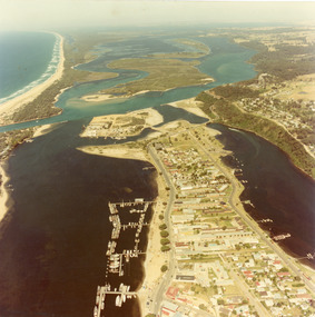 Lakes Entrance Historical Society
Photograph - Lakes Entrance, 1980c
Colour photograph aerial view of township of Lakes Entrance, showing western end of town, Bullock Island, Cunninghame Arm and North Arm, man made entrance, and distant view of outer barrier, island and shoreline. Lakes Entrance Victoriawaterways, township, bridges -
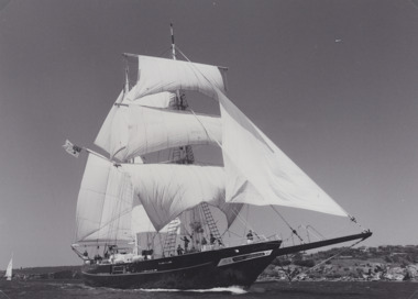 Lakes Entrance Historical Society
Photograph - Tall ship STS Young Endeavour 1988, 1988
Sepia toned photograph showing the Tall ship STS Young Endeavour in full sail with number of crew and or passengers on board. Rocky shoreline in background. Australia. Also two other black and white photographs of Training Ship Young Endeavour boats and boating, sailing, celebrations, events -
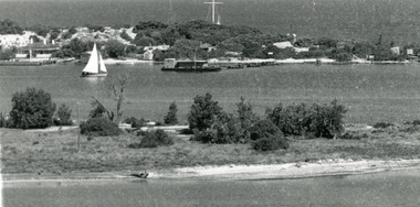
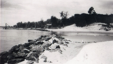 Lakes Entrance Historical Society
Photograph - Western sand Hummocks, 1946
Black and white photograph showing lake shoreline on western side of entrance piers, with rock retaining wall, walings and crane left middle distance and front of Schnapper cottage, dense vegetation on dune and some erosion to beach. Lakes Entrance Victoria machinery, waterfront, houses -
 Lakes Entrance Historical Society
Postcard - Post Office Jetty, Valentine Series, 1930c
Coloured postcard of the Post Office Jetty, showing two buildings on jetty, boats moored, and steamer leaving the jetty. Shoreline edged with bluestone, small Great War Memorial cypress tree, surrounded by wooden tree guard. Lakes Entrance Victoriamemorials, waterfront, boats and boating -
 Lakes Entrance Historical Society
Photograph - Kalimna Jetty, 1930
Black and white photograph of Kalimna Jetty, showing jetty, storage shed, boat shed, navigation light on end of jetty, and a launch slipped beside boathouse, steep cliffs bordering shoreline, sign on jetty for Kalimna Hotel, Lakes Entrance Victoriawaterways, jetties -
 Lakes Entrance Historical Society
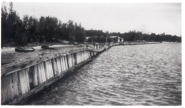
Photograph - Hopetoun Channel, 1946
Black and white photograph showing walings along shoreline west of entrance piers and Schnapper Cotttage further along. Dense vegetation on dunes, several small boats on beach behind walings, Hopetoun channel right foreground. Lakes Entrance Victoriahouses, waterfront -
 Lakes Entrance Historical Society
Postcard - S.S. Gippsland, 1910 c
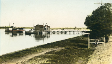
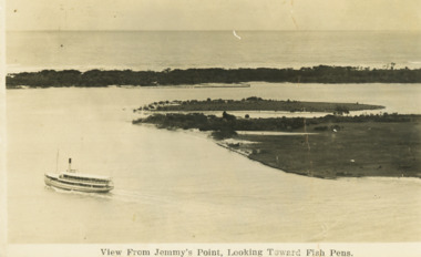
Note on back Happy Christmas to all from Aunt AliceBlack and white postcard showing SS Gippsland in Reeves Channel below Jemmys Point heading towards town East end of Rigby and Snake Island shown Fish pens visible along Hopeton Channelk shoreline Lakes Entrance VictoriaView from Jemmys Point towards fish pensships and shipping, waterways, correspondence -
 Lakes Entrance Historical Society
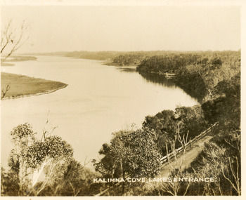
Postcard - Reeves Channel, Valentine Series, 1930c
Black and white small format postcard of Reeves Channel Gippsland Lakes, taken from Jemmys Point. It shows a glimpse of the Princes Highway, the steep shoreline of the mainland opposite Rigby Island with Fraser Island and Flannagan Island in distance. Lakes Entrance VictoriaKalimna Cove Lakes Entranceislands, waterways, topography -
 Lakes Entrance Historical Society
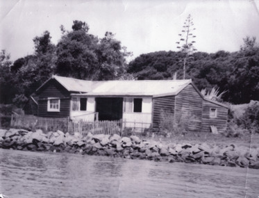
Photograph - Schnapper Cottage, 1944
Black and white photograph showing, Schnapper cottage on western side of entrance. Dark weatherboards, front partially screened in, picket fence along front, rocks along shoreline, thick vegetation on dunes, tall century plant at rear of house. Lakes Entrance Victoria waterfront, historic buildings -
 Lakes Entrance Historical Society
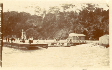
Photograph - Kalimna Jetty, 1930c
Black and white photograph of Kalimna Jetty. It shows a substantial jetty and landing, storage shed and boat shed, navigation light on end of jetty, many people on jetty, perhaps waiting for arrival of passenger steamer, in background steep cliffs bordering shoreline. Lakes Entrance Victoriawaterways, topography, jetties -
 Ballarat Heritage Services
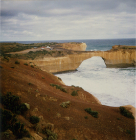
Photograph, London Bridge, Great Ocean Road, 01/1990
London Bridge, pre 1990 was a double-spanning bridge connected to the mainland. The stack was created over hundreds of years, with the weaker layers toward the base being eroded away by wind and water to form the two bridges. The span closer to the shoreline collapsed unexpectedly on 15 January 1990, leaving two visitors, whilst uninjured, stranded on the outer span before being rescued by helicopter. Two coloured photographs of the London Bridge, on the Great Ocean Road. This photo was taken days before the collapse of the geological feature. The photographer walked across the bridge to the warning of her mother "if you go over there and it collapses you will be stuck. After the collapse it was renamed London Arch. london bridge, great ocean road, london bridge, peterborough, london arch, shipwreck coast, 12 apostles -
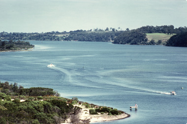
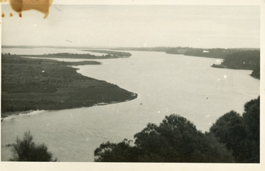 Lakes Entrance Historical Society
Photograph - Lake King, 1950c
Also copy of same view, stained, 9 x 14Black and white photograph of the Narrows and Reeves Channel of Lake King, Gippsland Lakes. It shows Rigby, Fraser, and Flannagan Islands opposite the steep shoreline of the mainland. Taken from Jemmy's Point, it shows a recently built groyne from Rigby Island into the Narrows. Lakes Entrance Victoriaislands, waterways, topography