Showing 82 items
matching the deep mines of bendigo
-
 Bendigo Historical Society Inc.
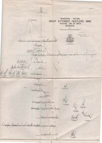
Map - STRUGNELL COLLECTION: HUSTLER'S LINE OF REEFS, BENDIGO, September 1913
Map, Hustler's Line of Reefs, Great Extended Hustler's Mine, Bendigo, Transverse Section. Plate No. X11 (12). Bulletin No 33 Signed H.A.Whitelaw Underground survey Office Bendigo September 1913 Drawing shows mine shaft to over 3454 feet deep and appears to show samples of connecting horizontal shafts with their respective mineral contentsUnderground Survey Office, Bendigo.map, bendigo, great extended hustler's mine -
 Bendigo Historical Society Inc.
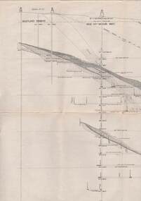
Map - STRUGNELL COLLECTION: HUSTLER'S LINE OF REEFS, BENDIGO, September 1913
Map, Hustler's Line of Reefs, Great Extended Hustler's Mine, Longitudinal Section Plate No X111 (13). Bulletin No 33 Signed H.A.Whitelaw Underground survey Office Bendigo September 1913 Drawing shows mine shaft to over 3454 feet deep and appears to show samples of connecting horizontal shaftsUnderground Survey Office, Bendigo.map, bendigo, great extended hustler's mine -
 Bendigo Historical Society Inc.
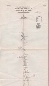
Map - STRUGNELL COLLECTION: HUSTLER'S LINE OF REEF, BENDIGO, September 1913
Map, Hustler's Line of Reef, Hustler's Royal Reserve No. 2 Co, Bendigo,Transverse Section, Plate No.V11 (7). Bulletin No 33 Signed H.A.Whitelaw Underground survey Office Bendigo September 1913 Drawing shows mine shaft to over 1640 feet deep and appears to show samples of connecting horizontal shafts with their respective mineral contentsUnderground Survey Office, Bendigo.map, bendigo, hustler's royal reserve no. 2 mine* -
 Bendigo Historical Society Inc.
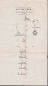
Map - STRUGNELL COLLECTION: HUSTLER'S LINE OF REEFS, BENDIGO, September 1913
Map, Hustler's Line of Reef, Hustler's Royal Reserve No. 2, Park Shaft, Bendigo, Plate No. 1X (9). Bulletin No 33 Signed H.A.Whitelaw Underground survey Office Bendigo September 1913 Drawing shows mine shaft to over 1099 feet deep and appears to show samples of connecting horizontal shafts with their respective mineral contentsUnderground Survey Office, Bendigo.map, bendigo, hustler's royal reserve no. 2 mine* -
 Bendigo Historical Society Inc.
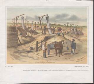
Painting - CAROL HOLSWORTH COLLECTION: 1970 NATIONAL BANK PAINTING 'DEEP SINKING - BALLARAT'
1970 National Bank painting reproduction 'Deep Sinking , Ballarat' by S.T.Gill c. 1855 Below the picture title the words - Reproduced by the National Bank in 1970 from the lithograph in the La Trobe Collection , State Library of Victoria , by permission of the Library Council of Victoria .Also on the painting is written -James J Blondell & Co Melbourne 1855. The painting shows mine shafts with windsails and windlasses a horse and cart , three men in the foreground several in the distancepainting, watercolour, gold diggers -
 Bendigo Historical Society Inc.
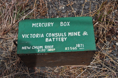
Container - MERCURY BOX: A.V. PALMER. VICTORIA CONSULS MINE AND BATTERY, NEW CHUM REEF
Very heavy Green Metal Box with two steel handles with the following label. Mercury Box - Victoria Consuls Mine and Battery, New Chum Reef. 3120' deep , 1871 , 52566 oz. On the side of the box is painted. A.V. Palmer. The Box is approx 400mm x 200mmA.V.Palmer -
 Bendigo Historical Society Inc.
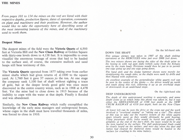
Document - LONG GULLY HISTORY GROUP COLLECTION: DESCRIPTION OF PHOTOS
Page titled The Mines. It has the description of the two black and white photos. Down the Shaft is on the left-hand side and Deep Underground is on the right-hand side. Also on the page is some information on the Deepest Mines. Mentioned are the Victoria Quartz of 4,593 feet and closed in 1913 because of flooding. The New Chum Railway of 4.138 feet closed in 1910.bendigo, history, long gully history group, the long gully history group - description of photos, hercules, shenandoah, new chum railway, victoria quartz -
 Bendigo Historical Society Inc.
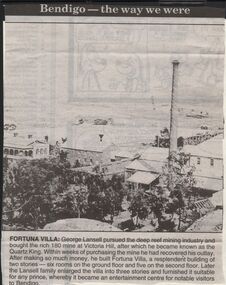
Newspaper - JENNY FOLEY COLLECTION: FORTUNA VILLA
Bendigo Advertiser "The way we were" from 1999. Fortuna Villa: George Lansell pursued the deep reef mining industry and bought the rich 180 mine at Victoria Hill, after which he became known as the Quartz King. Within weeks of purchasing the mine he had recovered his outlay. After making so much money, he built Fortuna Villa, a resplendent building of two stories - six rooms on the ground floor and five on the second floor. Later the Lansell family enlarged the villa into three stories and furnished it suitable for any price, whereby it became an entertainment centre for notable visitors to Bendigo.newspaper, bendigo advertiser, the way we were -
 Bendigo Historical Society Inc.
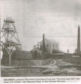
Newspaper - JENNY FOLEY COLLECTION: DIG DEEP
Bendigo Advertiser "The way we were" from 1999. Dig deep: Lansell's 180 mine on the New Chum line. The mine was 3361 feet deep and located near Marong Road, in the Victoria Hill area.newspaper, bendigo advertiser, the way we were -
 Bendigo Historical Society Inc.
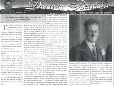
Newspaper - LONG GULLY HISTORY GROUP COLLECTION: THE MINE FLOODING CRISIS - FINALE OF THE VICTORIA QUARTZ
Copy of an article from the Bendigo Weekly titled Discover Bendigo The Mine Flooding Crisis - Finale of the Victoria Quartz by James Lerk. The lack of suitable machinery, insufficient knowledge of where the water was coming from, need for Government support, and the pegged price of gold, all contributed to the cessation of deep mining. The Victoria Quartz decided to allow tributers for work the upper levels. By 1913, the Company found it uneconomic to allow the tributers to continue working the upper levels and the poppet head and machinery were sold. During the Great Depression Ernest Smith, Davic Holden, Jack Harrison and David Patullo worked above the water line and did well enough to help their families from the worst effects of the Great Depression. Later Dave Patullo continued to work at the Victoria Quartz while the other three obtained employment in other mines. The article has a photo of David Patullo.bendigo, history, long gully history group, the long gully history group - the mine flooding crisis - finale of the victoria quartz, bendigo weekly, james lerk, victoria quartz mine, brough smyth, bendigo advertiser, victoria quartz company, great depression, ernest smith, david holden, jack harrison, david patullo, government battery eaglehawk -
 Bendigo Historical Society Inc.
Document - AILEEN AND JOHN ELLISON COLLECTION: BENDIGO HISTORICAL INFORMATION
9 pages document City of Bendigo historical information. After a brief description of the area, population, dwellings, city revenues, amount of gold and value of gold mined there is a timeline of the history of Bendigo starting in 1840 when the site of Bendigo was included in the Ravenswood run to 1891 when the city of Sandhurst changed to City of Bendigo. The following 8 pages dig deeper in the history starting with the find of the first gold nugget and describing the various industries that developed in the city. A description of the climate, agricultural activities, prominent people and buildings is also given.bendigo, history, city history -
 Bendigo Historical Society Inc.
Map - GUIDE MAP OF BENDIGO & EAGLEHAWK, Late 1920's
Map. Guide Map of Bendigo & Eaglehawk. Light brown coloured booklet containing folded map of Bendigo and Eaglehawk. Outer cover is printed in blue and red ink and states - With compliments of J H Curnow & Son, Auctioneers, Real Estate Agents, Farm & Dairy Produce Merchants, Bendigo. Printed by J B Young, Lithographer. Map shows tramways & bus routes. Map shows Agricultural Showgrounds located between Park Street, Water Street, Barnard Street and Bridge Lane. Also shows Acclimitization Reserve located behind The Botanical Gardens at White Hills. Shows the location of Sailors Gully, Peg-Leg Gully, Jobs Gully, California Gully, Long Gully, Ironbark Gully, Golden Gully, Poverty Gully, Sheepshead Gully, Charcoal Gully, Eaglehawk Creek, Bendigo Creek and Back Creek. Contains interesting facts about Bendigo - Area 7,900 acres. Population - 26,000. First Council elected - 1855. Proclaimed a Borough - 1863. Proclaimed a City - 1871. Gold Rush broke out - 1851. For first 10 years gold yield averaged 8,600 ozs. per week . Total gold yield to 1923 - 572 tons valued at 82,000,000 pounds. Deepest mines - Victoria Quartz 4,614 ft., New Chum Railway 4,318 ft. 13 mines over 3.000 ft. deep. 53 mines over 2,000 ft. deep. Sewering of City commenced 1922, all principal buildings now sewered. Map printed by Arnall & Jackson, General Printers, Stationers & Engravers, 476 Collins Street. Map displays advertisement for J H Curnow & Son, Bendigo's leading Auctioneer and Estate Agents, Mitchell & Queen Sts. Bendigo. Map Scale 20 chs. = 1 in.cottage, miners, guide map of bendigo and eaglehawk -
 Bendigo Historical Society Inc.
Map - GUIDE MAP OF BENDIGO & EAGLEHAWK, Late 1920's
Map. Guide map of Bendigo & Eaglehawk. Folded map of Bendigo & Eaglehawk with blue outer cover booklet. Map is compiled by E E Parker, Eaglehawk. Map shows tramways, bus routes and cost one shilling. Map shows Agricultural Showgrounds located between Park Street, Water Street, Barnard Street and Bridge Lane. Also shows Acclimitization Reserve located behind the Botanical Gardens at White Hills. Shows the location of Sailors Gully, Peg-Leg Gully, Jobs Gully, California Gully, Long Gully, Ironbark Gully, Golden Gully, Poverty Gully, Sheepshead Gully, Charcoal Gully, Eaglehawk Creek, Bendigo Creek and Back Creek.Contains interesting facts about Bendigo:- Area - 7,900 acres, Population - 26,000, First Council elected - 1855, Proclaimed a City - 1871. Gold Rush broke out - 1851. For first 10 years gold yield averaged 8,600 ozs. Per week. Total gold yield to 1923 - 572 tons valued at 82,000,000 pounds. Deepest mines - Victoria Quartz 4,614 ft., New Chum Railway 4,318 ft., 13 mines over 3,000ft. deep, 53 mines over 2,000 ft. deep. Sewering of City commenced 1922. All principal buildings now sewered. Map printed by Arnall & Jackson, General Printers, Stationers & Engravers, 476 Collins Street. Outer map blue cover printed in red and blue ink by J B Young, Lithographer. Map displays advertisement for Bendigo Timber Co. Outer blue cover displays advertisement for Campbell Connelly & Co. Pty. Ltd, Ironmongers, Timware Manufacturers, Plumbers, Sewerage Contractors, High and Forest Sts, Bendigo 9outside back cover) and for Hartleys ( J L Shoosmith) Bendigo, displaying Indian Motor Cycles (inside back cover).map, bendigo, township, guide map of bendigo & eaglehawk -
 Bendigo Historical Society Inc.
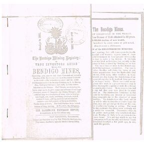
Document - THE BENDIGO MINING REGISTRY
Photocopy of The Bendigo Mining Registry or True Investors guide to all the Bendigo Mines in 1851 and up to 1883. Contains an original poem, Index, names and addresses of Legal Managers, names of Companies and Mining Managers, and reference page to a description of every mine in Bendigo, with length, size, depth, machinery, dividends, capital, number of shares, paid-up, and historical and scientific sketches - past and present - of the main situations. Twelve Lines of Reefs. The Gold Problem Scare Solved. Success of Deep Sinking. E - W & N. S. Parallelograms.document, gold, bendigo mines 1851 - 1883, the bendigo mining registry, r a murray, hay kirkwood, wm welch, district survey office, geological survey of victoria -
 Bendigo Historical Society Inc.
Slide - DIGGERS & MINING. DIGGERS AND MINERS, c1865
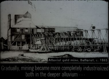
Diggers & Mining. Diggers and miners. Alluvial gold mine, Ballarat, c. 1865. Gradually, mining became more completely industrialized both in the deeper alluvium - - - Slide shows the building at the mine, with the raised rails to take the rock raised from in the mine to be crushed to allow the gold to be extracted. The mine's flag is flying. Markings: 28 994:LIF I. Used as a teaching aid.hanimounteducation, tertiary, goldfields -
 Bendigo Historical Society Inc.
Slide - DIGGERS & MINING. DIGGERS AND MINERS, c1859
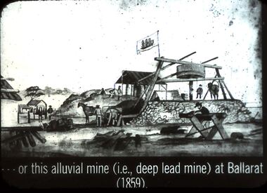
Diggers & Mining. Diggers and miners. Or this alluvial mine (i.e., deep lead mine) at Ballarat (1859). Slide shows men at work at the deep lead mine at Ballarat, mine flag flying. Horse walking in circles at the puddler, a man appears to be seated on what looks like a swing at the puddler. In the foreground a man sawing timber, several piles of timber are close by. A building in background.- - - Markings: 27 994:LIF I. Used as a teaching aid.hanimounteducation, tertiary, goldfields -
 Bendigo Historical Society Inc.
Slide - DIGGERS & MINING. GETTING THE GOLD, c1850s
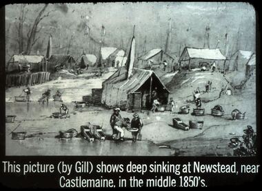
Diggers & Mining. Getting the Gold. Slide: This picture (by Gill) Shows deep sinking at Newstead, near Castlemaine, in the middle 1850's. Picture shows miners puddling and panning for gold, awnings erected over mine shafts in the background. Markings: 40 994.LIF:4. Used as a teaching aid.haniomunteducation, tertiary, goldfields -
 Bendigo Historical Society Inc.
Slide - DIGGERS & MINING. GETTING THE GOLD, c1853
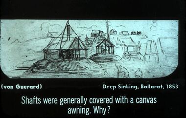
Diggers & Mining. Getting the Gold. Slide: (von Guerard) Deep Sinking, Ballarat, 1853. Shafts were generally covered with canvas awning. Why? Slide shows canvas awnings over mine shafts. Markings: 25 994.LIF:4. Used as a teaching aid.hanimounteducation, tertiary, goldfields -
 Bendigo Historical Society Inc.
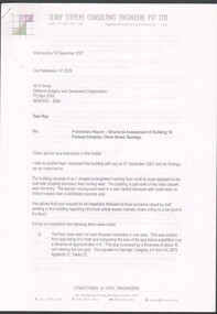
Document - Preliminary report of Structural assessment Fortuna
Fortuna Villa was initially commenced as a modest single storey home in 1861 next to the 180 Mine by Theodore Ballerstedt, who sold the mine and house to George Lansell in 1869. Lansell already owned the adjacent Fortuna Mine, and through deeper mining techniques greatly expanded the mine's operation, his personal wealth, and the house and grounds. Lansell was soon known as the 'Quartz King', Australia's first gold mining millionaire and credited as the driving force behind much of Bendigo's prosperity. He continuously added to and expanded the villa, decorating it extravagantly with the finest of artworks and materials, into a sprawling mansion with extensive landscaped grounds, to create a house and grounds of a size and grandeur with few rivals in Australia. After his death in 1907, his second wife Edith carried on with improvements, creating a house and grounds developed over 50 years. The attached mine also contributes to its significance, being one of the richest mines in Bendigo, and at one stage probably the deepest gold mine in the world at 3176 feet. The 1875 crushing works are attached directly to the mansion, and the mine's tailings and settling ponds (turned into ornamental lakes) represent a direct link between George Lansell's wealth and its source. Fortuna was compulsorily acquired by the Commonwealth in 1942 as the Cartographic Headquarters of the Australian Survey Corps during World War II, and many ancillary structures were added while preserving the main house and ornamental grounds. Victorian Heritage Database Report https://vhd.heritagecouncil.vic.gov.au/places/68334/download-reportPreliminary report of Structural assessment of Building 16 Fortuna Complex, Chum Street, Bendigo. Four page preliminary report finding the building is structurally safe as at Wed 19 December 2007 with three recommendations. Prepared for DIGO by Structural Engineers - Terry Stevens Consulting Engineers Pty Ltd.fortuna, structural assessment -
 Bendigo Historical Society Inc.
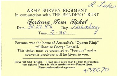
Ephemera - Tour Ticket
Fortuna Villa was initially commenced as a modest single storey home in 1861 next to the 180 Mine by Theodore Ballerstedt, who sold the mine and house to George Lansell in 1869. Lansell already owned the adjacent Fortuna Mine, and through deeper mining techniques greatly expanded the mine's operation, his personal wealth, and the house and grounds. Lansell was soon known as the 'Quartz King', Australia's first gold mining millionaire and credited as the driving force behind much of Bendigo's prosperity. He continuously added to and expanded the villa, decorating it extravagantly with the finest of artworks and materials, into a sprawling mansion with extensive landscaped grounds, to create a house and grounds of a size and grandeur with few rivals in Australia. After his death in 1907, his second wife Edith carried on with improvements, creating a house and grounds developed over 50 years. The attached mine also contributes to its significance, being one of the richest mines in Bendigo, and at one stage probably the deepest gold mine in the world at 3176 feet. The 1875 crushing works are attached directly to the mansion, and the mine's tailings and settling ponds (turned into ornamental lakes) represent a direct link between George Lansell's wealth and its source. Fortuna was compulsorily acquired by the Commonwealth in 1942 as the Cartographic Headquarters of the Australian Survey Corps during World War II, and many ancillary structures were added while preserving the main house and ornamental grounds. Victorian Heritage Database Report https://vhd.heritagecouncil.vic.gov.au/places/68334/download-reportTicket for Fortuna Villa Tour conducted by the Army Survey Regiment and the National Trust. 31/12/1985. Black printing on yellow card.fortuna villa, tour -
 Bendigo Historical Society Inc.
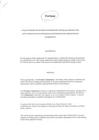
Document - Preservation proposal
Fortuna Villa was initially commenced as a modest single storey home in 1861 next to the 180 Mine by Theodore Ballerstedt, who sold the mine and house to George Lansell in 1869. Lansell already owned the adjacent Fortuna Mine, and through deeper mining techniques greatly expanded the mine's operation, his personal wealth, and the house and grounds. Lansell was soon known as the 'Quartz King', Australia's first gold mining millionaire and credited as the driving force behind much of Bendigo's prosperity. He continuously added to and expanded the villa, decorating it extravagantly with the finest of artworks and materials, into a sprawling mansion with extensive landscaped grounds, to create a house and grounds of a size and grandeur with few rivals in Australia. After his death in 1907, his second wife Edith carried on with improvements, creating a house and grounds developed over 50 years. The attached mine also contributes to its significance, being one of the richest mines in Bendigo, and at one stage probably the deepest gold mine in the world at 3176 feet. The 1875 crushing works are attached directly to the mansion, and the mine's tailings and settling ponds (turned into ornamental lakes) represent a direct link between George Lansell's wealth and its source. Fortuna was compulsorily acquired by the Commonwealth in 1942 as the Cartographic Headquarters of the Australian Survey Corps during World War II, and many ancillary structures were added while preserving the main house and ornamental grounds. Victorian Heritage Database Report https://vhd.heritagecouncil.vic.gov.au/places/68334/download-reportProposal for the formation of a Fortuna Commission to ensure the preservation of Fortuna Villa. Written by Daryl McClure. May 2012fortuna villa, preservation, daryl mcclure -
 Bendigo Historical Society Inc.
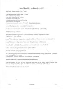
Document - ULSTER GOLD MINING COMPANY NO LIABILITY - UNITY MINE FIRE 8/10/1907 & FAMOUS GOLD MINES
Typed copy of recount by Albert Richardson of a fire at Unity Mine on Tuesday 8-10-1907. Report from the Bendigo Advertiser Wednesday October 9th 1907. Notes mention Fire Brigade, miners, how the fire started and how the men down the shaft escaped when the rope crash down the shaft. On the back is a handwritten carbon copy of notes titled Famous Gold Mines of Bendigo and Eaglehawk. Notes give yields of gold for alluvial and quartz mining. Deep Shafts in 1904 of which there were eleven with a depth of more than 3000 feet and 53 over 2000 feet and two which were more than 4000 feet. Wages for 1911 for Engine Drivers and Firemen and Boiler Attendants. Note on winding plants and air compressors.document, gold, ulster gold mining coy no liability, ulster gold mining company no liability, unity mine fire 8/10/1907, bendigo advertiser 9/10/1907, garden gully reef hotel, wm addicoat, louis pabst, edward morris, conrad inglefinger, edward fuller, frederick allen, wm whitford, mr jewell, carlisle mine, famous gold mines of bendigo and eaglehawk, new chum line, garden gully line, hustlers line, victoria quartz mine, new chum railway, mines report 1911 p15, albert richardson -
 Bendigo Historical Society Inc.
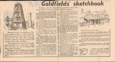
Newspaper - GOLDFIELDS SKETCHBOOK ARTICLE, BENDIGO ADVERTISER, 23rd July 1970
Newspaper article titled' Goldfields' sketchbook. Article on book release ' Bendigo and Eastern Goldfields Sketchbook with Drawings by Unk White and text by John Bechervaise, first published 1970, 64 pages, hardback edition, $1.95. Extract from article ' our poppet-head sketch is of the Deborah superstructure, rising above a shaft 2017 feet deep, the site on Quarry Hill being easily accessible. The mine yielded 52,000 ounces of gold and in 1954 was one of the last three mines all on the Deborah line of reef, to close down'Bendigo Advertiser July 23rd 1970.bendigo, mining, gold discovery, 'bendigo advertiser -
 Bendigo Historical Society Inc.
Document - MINING REPORTS - ANNUAL REPORT, SEC. FOR MINES & WATER SUPPLY 1904
... , Yield of Gold for Bendigo Goldfield, the deep mines, winze... of Gold Deep Mines new Chum Railway Lazarus New Chum Victoria ...BHS CollectionHandwritten notes from the Annual Report, Sec. for Mines & Water Supply for the Year 1904. Report mentions gold yield for the District of Bendigo and the Total for Victoria, quantity of ore treated, Value of gold per ounce for 1904 for Australian States, Yield of Gold for Bendigo Goldfield, the deep mines, winze in the New Chum Rly and Victoria Quartz, and the number of men employed in alluvial and quartz mining (gold) during 1904.document, gold, mining reports, mining reports, annual report sec for mines & water supply 1904, gold yield, value of gold, deep mines, new chum railway, lazarus new chum, victoria quartz, north johnsons, lansells 180, shenandoah, new chum & victoria, new chum consolidated, gt extended hustlers, eureka extended, princess dagmar -
 Bendigo Historical Society Inc.
Document - Pompeii Fountain & Adjacent Structures at "Fortuna"
Fortuna Villa was initially commenced as a modest single storey home in 1861 next to the 180 Mine by Theodore Ballerstedt, who sold the mine and house to George Lansell in 1869. Lansell already owned the adjacent Fortuna Mine, and through deeper mining techniques greatly expanded the mine's operation, his personal wealth, and the house and grounds. Lansell was soon known as the 'Quartz King', Australia's first gold mining millionaire and credited as the driving force behind much of Bendigo's prosperity. He continuously added to and expanded the villa, decorating it extravagantly with the finest of artworks and materials, into a sprawling mansion with extensive landscaped grounds, to create a house and grounds of a size and grandeur with few rivals in Australia. After his death in 1907, his second wife Edith carried on with improvements, creating a house and grounds developed over 50 years. The attached mine also contributes to its significance, being one of the richest mines in Bendigo, and at one stage probably the deepest gold mine in the world at 3176 feet. The 1875 crushing works are attached directly to the mansion, and the mine's tailings and settling ponds (turned into ornamental lakes) represent a direct link between George Lansell's wealth and its source. Fortuna was compulsorily acquired by the Commonwealth in 1942 as the Cartographic Headquarters of the Australian Survey Corps during World War II, and many ancillary structures were added while preserving the main house and ornamental grounds. Victorian Heritage Database Report https://vhd.heritagecouncil.vic.gov.au/places/68334/download-reportConservation report for the Pompeii Fountain & Adjacent Structures at "Fortuna" Chum Street, Golden Square, Victoria. Prepared for Fortuna Historical Committee. March 1996.Halina Eckersley, Architect & Conservation Planner, Kewpompeii fountain, greenhouse, fortuna lake, gardens -
 Bendigo Historical Society Inc.
Document - ALBERT RICHARDSON COLLECTION: NORTH JOHNSON'S MINE, GARDEN GULLY REEF
Two page typed document detailing information of the North Johnson's Mine on the Garden Gully line of reef. The mine was located in California Gully, the shaft is approximately 66 yards north of Thomas Street. The shaft was 3,480 ft deep and sunk with the line of reef. This company, together with its northern neighbour the Rose of Denmark, first became a prominent gold producer in 1867. For its size, one of the richest mines in Bendigo.bendigo, mining, north johnsons mine -
 Bendigo Historical Society Inc.
Document - DRAINAGE PROBLEMS - NEW CHUM MINES DRAINAGE PROBLEMS 1910
Handwritten extract from the Bendigo Advertiser 20/8/1910 Page 8. ''New Chum Mines. Unwatering of the deep levels is being carried on as expeditionsly as was expected by the authorities. In the last four days, the water has only been lowered 14 feet at the Victoria Quartz Mine. The water stood at the 3,226 feet level yesterday. The slow progress being made this week is no doubt due to the large quantity in the workings at some of the levels.'' From the Bendigo Advertiser 27/8/1910 Page 9. ''New Chum Mines. Very slow progress being made. At Victoria Quartz, the water was lowered 32 feet for the week, and is now at 3258 feet. New Chum Railway lowered the water 17 feet and the present level of the water is at 1796 feet. The Lazarus are raising water from 2157 feet. The water has ceased flowing into the New Chum and Victoria through the connecting level with the Lazarus Mine at about 2,500 feet. As the Victoria Quartz is down 4,614 feet, there is still a considerable quantity of water to get out before sinking of the shaft can be resumed.''document, gold, drainage problems, drainage problems, new chum mines drainage problems 1910, bendigo advertiser 20/8/1910 page 8 & 27/8/1910 page 9, new chum mines, victoria quartz, new chum railway, lazarus, new chum and victoria -
 Bendigo Historical Society Inc.
Document - DRAINAGE PROBLEMS - WATER PROBLEMS
Two handwritten pages with extracts from the Bendigo Advertiser Mining Intelligence. Notes mention making arrangements with other mines to resume bailing, Victoria Quartz still shaft sinking despite strong flow of water, Lansell's 180 preparing to bail water from the deep levels, so that the Victoria Quartz may continue shaft sinking and finishing cutting of plat at 4454 ft. Also a weather report on the 14/6/1910. From the Albert Richardson Mining History Collection.gold, drainage problems, drainage problems, water problems, bendigo advertiser mining intelligence 18/4/1910, 9/5/1910, 23/5/1910, 30/5/1910, 6/6/1910, 13/6/1910, victoria quartz, lazarus coy, lansell's 180, albert richardson -
 Bendigo Historical Society Inc.
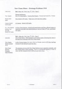
Document - DRAINAGE PROBLEMS - DRAINAGE PROBLEMS 1910
Handwritten notes from Bendigo Advertiser reports. (1) Mr J. H. Craig reports- Victoria Reef Quartz - Cleaned and tested No 3 boiler. Have bailed 3,905 tanks. Water now 2.953 feet from surface. At Lazarus - Bailed 4,828 tanks. At New Chum Railway - Cleaned and tested boilers and flues, effected repairs to machinery and shaft, and started bailing at 3 pm on Friday 29th inst, and bailed 965 tanks. Bendig Advertiser 3/8/1910 Page 2 Mining Intelligence. (2) New Chum Mines - Better progress is now being made in lowering the water in the deep level workings at the New Chum Mines. At the Victoria Quartz, the water which on Monday stood at 3073feet, has been lowered 70 feet during the past four days. The pumping service at the New Chum Railway was in operation yesterday, and the winding plant is fully occupied. There is a considerable quantity of water toraise, and the companies have a difficult task before them. Bendigo Advertiser 5/8/1910 Page 2. Document from Albert Richardson Collection of mining history.gold, drainage problems, new chum drainage association, new chum mines drainage problems 1910, bendigo advertiser 3/8/1910 page 2, mr j h craig, victoria reef quartz, lazarus, new chum railway, bendigo advertiser 5/8/1910 page 2, albert richardson -
 Bendigo Historical Society Inc.
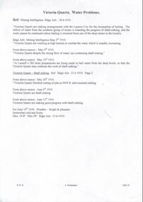
Document - DRAINAGE PROBLEMS - VICTORIA QUARTZ
Handwritten copy of reports from the Bendigo Advertiser regarding water in the mine. (1) The bailing of water is occupying attention in other mines (from Shamrock North) to the Victoria Quartz. The water despite the efforts of the companies engaged bailing, continues to rise. Bendigo Advertiser July 18th Page 3. (2) Victoria Quartz Half Yearly Meeting, Lapsed, No quorum. Directors' Report: Sinking of shaft carried on till 14th June, when it was 4,614 ft. deep. Progress very satisfactory. Progress very satisfactory considering increase of water. As water was interfering with work, made arrangements on 3rd May, that 180 Mine should bail, and Minister of Mines agreed to allow, expense to be charged against work subsidised by Government. Arrangements now made for Lazarus, 222 and New Chum Consolidated mines to bail to unwater line of reef. Victoria Consols, Ironbark, 83, and Hercules and Energetic Companies have undertaken to contribute to cost, and Gov't will allow this to be charged on grant. Document from Albert Richardson Collection of mining history.gold, drainage problems, new chum drainage association, victoria quartz, bendigo advertiserjuly 18th page 2 mining intelligence, bendigo advertiser 20/7/1910 page 3, lazarus, 222, new chum consolidated, victoria consols, ironbark, 83, hercules and energetic, albert richardson