Showing 140 items
matching victoria (reef) quartz
-
 Marysville & District Historical Society
Photograph (item) - Black and white photograph, Unknown
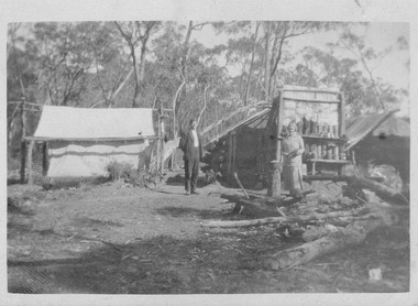
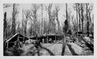
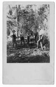
... . The Golden Bower gold mine was a quartz reef mine. William Edward ...An early black and white photograph of the Golden Bower mine in the Cumberland Valley in Victoria.An early black and white photograph taken at the Golden Bower Mine in the Cumberland Valley in Victoria. The Golden Bower gold mine was a quartz reef mine. William Edward Chester discovered the Golden Secret gold vein which became part of the Golden Bower Mine at Chesterville near Donovans Creek on the Cumberland goldfield which he mined with George Locke until the late 1930s. golden bower gold mine, cumberland valley, victoria, quartz reef mining, water-powered battery, william edward chester, george locke, chesterville, donovan's creek, cumberland goldfield -
 Marysville & District Historical Society
Photograph (item) - Black and white photograph, Unknown
... . The Golden Bower gold mine was a quartz reef mine. William Edward ...An early black and white photograph of the Golden Bower mine camp in the Cumberland Valley in Victoria.An early black and white photograph taken at the Golden Bower Mine in the Cumberland Valley in Victoria. The Golden Bower gold mine was a quartz reef mine. William Edward Chester discovered the Golden Secret gold vein which became part of the Golden Bower Mine at Chesterville near Donovans Creek on the Cumberland goldfield which he mined with George Locke until the late 1930s. golden bower gold mine, cumberland valley, victoria, quartz reef mining, water-powered battery, william edward chester, george locke, chesterville, donovan's creek, cumberland goldfield -
 Marysville & District Historical Society
Photograph (item) - Black and white photograph, Unknown
... in Victoria. The Golden Bower gold mine was a quartz reef mine ...An early black and white photograph taken at the Golden Bower Mine Camp in the Cumberland Valley in Victoria.An early black and white photograph taken at the Golden Bower Mine in the Cumberland Valley in Victoria. The Golden Bower gold mine was a quartz reef mine. William Edward Chester discovered the Golden Secret gold vein which became part of the Golden Bower Mine at Chesterville near Donovans Creek on the Cumberland goldfield which he mined with George Locke until the late 1930s. golden bower gold mine, cumberland valley, victoria, quartz reef mining, water-powered battery, william edward chester, george locke, chesterville, donovan's creek, cumberland goldfield -
 Marysville & District Historical Society
Photograph (item) - Black and white photograph, Unknown
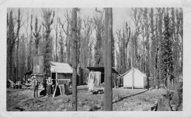
... in Victoria. The Golden Bower gold mine was a quartz reef mine ...An early black and white photograph taken at the Golden Bower Mine in the Cumberland Valley in Victoria.An early black and white photograph taken at the Golden Bower Mine in the Cumberland Valley in Victoria. The Golden Bower gold mine was a quartz reef mine. William Edward Chester discovered the Golden Secret gold vein which became part of the Golden Bower Mine at Chesterville near Donovans Creek on the Cumberland goldfield which he mined with George Locke until the late 1930s. golden bower gold mine, cumberland valley, victoria, quartz reef mining, water-powered battery, william edward chester, george locke, chesterville, donovan's creek, cumberland goldfield -
 Marysville & District Historical Society
Postcard (item) - Black and white postcard, Unknown
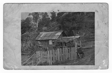
... in Victoria. The Golden Bower gold mine was a quartz reef mine ...An early black and white photograph taken at the Golden Bower Mine in the Cumberland Valley in Victoria.An early black and white photograph taken at the Golden Bower Mine in the Cumberland Valley in Victoria. The Golden Bower gold mine was a quartz reef mine. William Edward Chester discovered the Golden Secret gold vein which became part of the Golden Bower Mine at Chesterville near Donovans Creek on the Cumberland goldfield which he mined with George Locke until the late 1930s. POST CARD EMPIRE FOR CORRESPONDENCE FOR ADDRESS ONLY STAMPgolden bower gold mine, cumberland valley, victoria, quartz reef mining, water-powered battery, william edward chester, george locke, chesterville, donovan's creek, cumberland goldfield, postcard, souvenir -
 Marysville & District Historical Society
Postcard (item) - Black and white postcard, Unknown
... in Victoria. The Golden Bower gold mine was a quartz reef mine ...An early black and white photograph taken at the Golden Bower Mine Camp in the Cumberland Valley in Victoria.An early black and white photograph taken at the Golden Bower Mine Camp in the Cumberland Valley in Victoria. The Golden Bower gold mine was a quartz reef mine. William Edward Chester discovered the Golden Secret gold vein which became part of the Golden Bower Mine at Chesterville near Donovans Creek on the Cumberland goldfield which he mined with George Locke until the late 1930s. POST CARD CORRESPONDENCE. ADDRESS ONLY. KODAK/ AUSTRALIA 30/06/10 Rose Hill/ Fitzwilliam Street/ Kew Should have written/ to you months ago about the/ photos I took at Easter./ Sorry to say the one of the little/ girls was no good I expect/ you will recognise both these/ places/ K McDowell Mrs Fletcher/ Golden Bower Mine/ Via Marysville J Mahoneygolden bower gold mine, cumberland valley, victoria, quartz reef mining, water-powered battery, william edward chester, george locke, chesterville, donovan's creek, cumberland goldfield -
 Bendigo Historical Society Inc.
Document - THE JOHN BROWN KNITWEAR FACTORY AND ITS HISTORICAL ASSOCIATIONS
... ; Big 180 mine; Victoria Reef Quartz mine; Victoria Quartz...; Big 180 mine; Victoria Reef Quartz mine; Victoria Quartz ...''The John Brown Knitwear Factory and its Historical Associations'' (A Richardson), a. Two pages of typed text; b. Two pages of hand-written text. References to: New Chum mine; Victoria mine; Big 180 mine; Victoria Reef Quartz mine; Victoria Quartz company; Little 180 mine; New Chum and Victoria crushing battery; ''Jeweller's Shop''; Advance mine;A. Richardsonbendigo, business, john brown knitwear, victoria hill, little 180 mine, new chum and the victoria crushing battery, marong road -
 Bendigo Historical Society Inc.
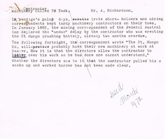
Document - ARTICLES FOR RHSV BENDIGO BRANCH NEWSLETTER MARCH 1972
... and sinking - (Grant and??Co), adjacent to private Victoria Reef...), adjacent to private Victoria Reef Quartz Co., later the Victoria ...Articles for RHSV Bendigo Branch Newsletter March 1972; 1. Article in ''Federal Australian'' (Jan 1882) re undue delays erecting the St Mungo crushing battery; 2. ''Moans and Groans'' re wages for miners and meeting at Royal Hotel of May 31st, 1873; reference to a Regulation of Mines law of Jan 1st 1874 (Angus McKay), margin note on handwritten copy states that ''Further information on (the) Act and the lot of the miners and engine drivers will be given in future issues of the Newsletter''; 3. Article with return and costs information about working on a claim - details of shaft and sinking - (Grant and??Co), adjacent to private Victoria Reef Quartz Co., later the Victoria Quartz.document, gold, mining in bendigo -
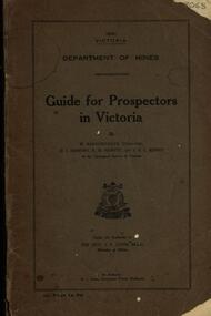 Federation University Historical Collection
Book, Guide for Prospectors in Victoria, 1931, 1931
... deposits, quartz reefs, indicators, economic minerals, assistance... quartz reefs alluvial deposits indicators victorian goldfields ...The handbook was intended for those with little experience who wanted to prospect of fossick.Grey soft covered book of 90 pages. Includes fold out map of a portion of Victoria showing auriferous areas and mineral localities. Also show Counties of Victoria and localities of minerals such as tin, antimony, copper, silver lead, Malybdenite, tungsten ores, manganese, platinum, osmiridium and iron. Chapter heading s include: working alluvial deposits, equipment, geology of Victoria, gold deposits, quartz reefs, indicators, economic minerals, assistance to prospectors, Miners' Right, mining bye-law, mining leases, forest regulations and glossary. Descriptions are given of a god dish, puddling tub, cradle, puddling machine, ground sluicing, boring, windlass, whim, hand dollying, sweeping, California pump, and wing dam.mining, baragwanath, gold, prospector, geology, quartz reefs, alluvial deposits, indicators, victorian goldfields, miners rights, mining leases, forest regulations, sluicing, sluice box, puddling machine, miner's cradle, whim, whip, california pump, gold nuggets, saddle reef, ballarat indicators, state batteries -
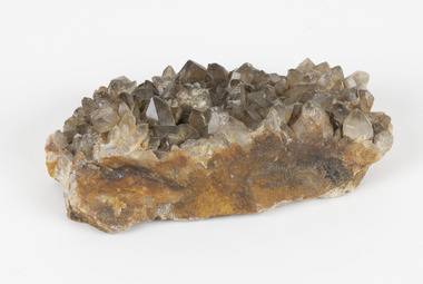 The Beechworth Burke Museum
Geological specimen - Smoky quartz crystals, unknown
Quartz is an extremely common mineral to find across the world. Quartz can have two forms; Microcrystalline quartz or Crystalline quartz. Microcrystalline quartz is a fine grain quartz where crystalline quartz is often a large crystal. This specimen is a crystalline quartz. Made of silicon oxide, this specimen is called smokey quartz crystals because of its brownish colour. However, the colour of quartz can vary. In addition, quartz are formed in deep-seated igneous rocks and crystallized through hot aqueous solutions. This type of crystal can be found all over Australia, including Beechworth in Victoria. Other places quartz can be found is the Ashburton River area in Western Australia, Marlborough in Queensland, the Lune River area in Tasmania and Kingsgate in New South Wales. This specimen is significant because it is common to find this kind of mineral. While the location of where this specimen was originally from is unknown, it highlights the many places in Australia where quartz is found. It demonstrates that quartz makes up a large portion of Australia's geology. In addition, quartz itself can vary in its colour and shape. This specimen represents one of these variations. That being smoky quartz crystals. This specimen is part of a larger collection of geological and mineral specimens collected from around Australia (and some parts of the world) and donated to the Burke Museum between 1868-1880. A large percentage of these specimens were collected in Victoria as part of the Geological Survey of Victoria that begun in 1852 (in response to the Gold Rush) to study and map the geology of Victoria. Collecting geological specimens was an important part of mapping and understanding the scientific makeup of the earth. Many of these specimens were sent to research and collecting organisations across Australia, including the Burke Museum, to educate and encourage further study.A large hand-sized quartz mineral with shades of brown and gray throughout.Smoky quartz / crystals /locality/ unknown / (needs a wash) /BBgeological specimen, geology, geology collection, burke museum, beechworth, microcrystalline, quartz, quartz mining, quartz reefs beechworth, smokey quartz crystals, crystals, crystalline, silicon oxide, brown, colour, igneous rocks, magma, ashburton river, western australia, marlborough, queensland, lune river, tasmania, kingsgate, new south wales, nsw -
 The Beechworth Burke Museum
Photograph, Unknown
The A1 Gold Mine is located north of Woods Point, near Jamieson, in the Upper Goulburn region of Victoria. Gold was discovered at the A1 site in 1861 and mining operations began in 1864. The A1 Mine Settlement refers to a small township known variously as Castle Reef, Castle Point, and Raspberry Creek, which developed in the 1860s around mining industry centred on a crushing machine that worked the three gold reefs in the area. Historically, the name "A1"referred to the high quality of gold found in the quartz reefs at depths of at least two thousand feet. Along with the Morning Star mine at Woods Point, the A1 gold mine produced almost sixty percent of Victoria's gold output in the 1950s to 1970s and continued operating until 1992 when it went into administration. Operations at the site were revived in 2016 and the A1 Mine is now considered one of Victoria's premier gold mines. The A1 mine is part of the extensive and prospective Lachlan Fold Belt, a north-west trending belt of tightly folded Early Devonian sedimentary rocks extending from New South Wales to Victoria. Mineralisation is hosted within or immediately adjacent to diorite dykes. Contemporary development of the 'Queens Lode' at the A1 mine signals a move from high-grade, narrow vein airleg mining into larger scale, mechanical mining designed to increase ore production volume. This original, undated photograph of the A1 Mine appears to depict an area or phase of disuse or abandonment. The aged and humble appearance of the cottage suggests association with the historical A1 Mine Settlement, therefore the image may have been taken prior to the 1950s-1970s revival period in which the A1 mine is known to have produced high gold yields. The photograph contributes to our understanding of the A1 Gold Mine's impact on the landscape and the social, environmental impacts of mining on communities and may be compared with others in the Burke Museum's extensive collection of mining photographs to deepen our understanding of mining in the Jamieson area.Black and white rectangular photograph printed on photographic paperReverse: 5577 / A1 Mine / Near Jamieson / Vic. /burke museum, beechworth museum, beechworth, gold fields, gold rush, victorian gold rush, mining tunnels, gold ming history, colonial australia, australian gold rushes, mining technology, beechworth historic district, indigo gold trail, indigo shire, upper goulburn shire, jamieson, woods point-walhalla goldfield, a1 gold mine, victorian high country, modern mining methods, orogenic gold province, gold mineralisation, devonian, dykes -
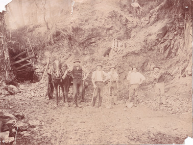 The Beechworth Burke Museum
Photograph
This photograph depicts a reef mine in Beechworth. Reef mining, or quartz reef mining, was common in 19th Century Victoria. This gold mining technique requires mine shafts to be sunk into underground quartz reefs, with horizontal tunnels dug from the original shaft at differing levels to find the gold-bearing rock. The quartz would then be hoisted to the surface, which would then be pounded to access the gold in its metallic state. Gold was discovered in Beechworth in February 1852, at Spring Creek. Within 11 months of that discovery, over 8000 hopeful prospectors quickly descended on this region, transforming it into a thriving, wealthy township. Reef mining and hydraulic sluicing were gold mining techniques used in this region in the 19th and early 20th centuries. This photograph interestingly contains dogs alongside the miners. While dogs have been recorded as deterrents to thieves in the Victorian goldfields, these dogs appear as companions to these men.The search for gold is ingrained into the history of Victoria and therefore, images like this one can reveal important information for society and technology for the date when the photograph was taken. It also shows a location where reef mining was undertaken which provides insight into the impact on the environment at a time when it was done. Although quartz is one of the most common minerals found in the earth's crust, it does not always contain gold. Those reefs that do are rare and highly sought after by prospectors. The Beechworth Burke Museum has additional images relating to gold mining which can be analysed and studied alongside images like this one.Sepia coloured rectangular photograph printed on gloss photographic paper. Obverse: Reverse: United Shire of Beechworth/ Shire Secretary/ Reef Mining, Beechworth./ 6167.abeechworth, burke museum, gold, gold mining, gold rush, victorian gold rush, reef mining, quartz, companion dog, horse and cart -
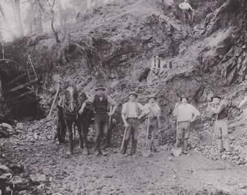 The Beechworth Burke Museum
Photograph - Photograph - Reproduction
This reproduced photograph depicts a reef mine in Beechworth. Reef mining, or quartz reef mining, was common in 19th Century Victoria. This gold mining technique requires mine shafts to be sunk into underground quartz reefs, with horizontal tunnels dug from the original shaft at differing levels to find the gold-bearing rock. The quartz would then be hoisted to the surface, which would then be pounded to access the gold in its metallic state. Gold was discovered in Beechworth in February 1852, at Spring Creek. 8000 hopeful prospectors quickly descended on this region within the year, transforming it into a thriving, wealthy township. Reef mining and hydraulic sluicing were gold mining techniques used in this region in the 19th and early 20th centuries. This reproduction photograph interestingly contains dogs alongside the miners. While dogs have been recorded as deterrents to thieves in the Victorian goldfields, these dogs appear as companions to these men.The search for gold is ingrained into the history of Victoria and therefore, images like this one can reveal important information for society and technology for the date when the photograph was taken. It also shows a location where reef mining was undertaken which provides insight into the impact on the environment at a time when it was done. The Beechworth Burke Museum has additional images relating to gold mining which can be analysed and studied alongside images like this one.Black and white rectangular reproduction photograph on gloss photographic paper. Obverse: Reverse: L is miners 26%/ 10 x 8/ 6167.bbeechworth, burke museum, gold, gold mining, gold rush, victorian gold rush, reef mining, quartz, companion dog, horse and cart -
 Federation University Historical Collection
Letter, Inward Correspondence to the Ballarat School of Mines, 1910, 08/1910
Inward Correspondence to the Ballarat School of Mines, August 1910letterhead, education department, gordon, c. brennan, l. eddy, state forests commission, edwin feild, royal victorian institute of architects, the steel company of australia, james martyn, clarke & co, ludwig alberti, scarsdale, thomas m. jude, justinian oxenham, clara davidson, robert davidson, j. roberts, h.b. silberberg & co, l. gilbert, macquarie steam brick yards, james dewar, r.j. flowerday, staffirdshire reef, john wilesmouth, bank of new south wales, victoria silicate brick company ltd, t.s. huggins, george f. roughhead, federal store, legislative assembly, andrew mckissock, city of ballarat, r. e. williams, ballarat school of mines battery assistant, edgar c. hurdsfield, bairnsdale school of mines, w. kingston, gordon technical college, h.l. langdon & co., felton grimwade, f.f. brunn, bendigo school of mines, gold buyers bill, chaffey salmon & dunne, h.j. thwaites, cobar, henry leahy, h. blyth, s. radcliff, archie buchanan, launceston, fairthorne and sons, sloanes and scotchmans united quartz mining company, james eton, albert bradford, 109 lyons st north -
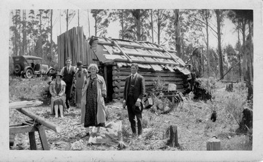
Marysville & District Historical Society
Document (item) - Gold Mine Prospectus, H.D. McKie, Prospectus of the New Golden Bower & Star Gold M.Co, 1896
A copy of the Prospectus of the New Golden Bower & Star Gold M.Co. near Marysville in Victoria.A copy of the Prospectus of the New Golden Bower & Star Gold M.Co. near Marysville in Victoria. The Golden Bower gold mine was a quartz reef mine. William Edward Chester discovered the Golden Secret gold vein which became part of the Golden Bower Mine at Chesterville near Donovans Creek on the Cumberland goldfield which he mined with George Locke until the late 1930s. new golden bower & star gold m.co., donovan's creek, nuggety gully creek, yarra track, marysville, victoria, share prospectus, upper yarra track, wood's point, victoria mount morgan gold mining co., british mount morgan mine, mr white, reefton turnoff, santa claus reef, bear's creek, mr r ely, bear's creek reef, big river, mr feely, new star reef, golden bower reef, a1 mining co, mr r m lee, locke's no.1 extended gold mining company, mr q dick -
Marysville & District Historical Society
Document (item) - Gold Mine Prospectus, Messrs Bruce & Robinson, Prospectus-Chester & Locke's Golden Secret Gold Mining Company, 1899
A copy of the prospectus for the Chester & Locke's Golden Secret Mining Company near Marysville in Victoria.A copy of the prospectus for the Chester & Locke's Golden Secret Mining Company near Marysville in Victoria. The Golden Bower gold mine was a quartz reef mine. William Edward Chester discovered the Golden Secret gold vein which became part of the Golden Bower Mine at Chesterville near Donovans Creek on the Cumberland goldfield which he mined with George Locke until the late 1930s. FOR PRIVATE CIRCULATIONshare prospectus, chester & locke's golden secret mining company, marysville, victoria, yarra track, upper yarra district, david newell, j.g. aikman, w.j. mountain, andrew barrie, gold mining, messrs w.p. jones and co., william chester, george locke, chesterville -
Marysville & District Historical Society
Document (item) - Historic Site Register Sheet, Parks Victoria, Historic Site Recording System-Site Register Sheet-Chester & Locke Mine, 1989
A copy of a historic site register sheet for the Chester and Locke gold mine near Marysville in Victoria.A copy of a historic site register sheet for the Chester and Locke gold mine near Marysville in Victoria. The Golden Bower gold mine was a quartz reef mine. William Edward Chester discovered the Golden Secret gold vein which became part of the Golden Bower Mine at Chesterville near Donovans Creek on the Cumberland goldfield which he mined with George Locke until the late 1930s. chester and locke mine, william chester, george locke, cambarville, yarra ranges, walker's hotel, marysville, victoria -
 Federation University Historical Collection
Book, Memoirs of the Geological Survey of Victoria No 14 The Ballarat Goldfields, 1923, 1923
William Baragwanath was educated at the Ballarat School of Mines, obtaining a Geology Certificate in 1911. After further study he went on the become Secretary for Mines, and Chief Mining Surveyor. Baragwanath was a Councillor of the Ballarat School of Mine from 1916 to 1950.Pink covered foolscap book of 257 pages and 32 maps and plans by William Baragwanath. Contents include topography, physiography, historical, geology, basalt, faults, dykes, minerals leads, alluvial mines, nuggets, structure of Ballarat West goldfields, structure of Ballarat East gold-field, quartz formation, indicators, defunct mines, existing mines, table of deepest shafts. Images include: section of the Ballarat Gold-Field, Dead HOrse Flat, lakes formed by Basalt Flows, Gong Gong Creek, Frenchman's Lead, Ballarat West Mines, LEases and positions of shafts (1857), puddling, White Horse Lead, Woah Hawp Canton, Ballarat Township mines, Sebastopol, syncline, Victoria United Line, First Chance Mine, Llanberris No 1 Mine, Saddle Reef, New Normanby Mine, Woah Hawp Canton Mine, South Star Mine, Sebastopol Plateau, south Woah Hawp Mine, Woah No. 2 Minegeology, geological survey no 14, ballarat, baragwanath, william baragwanath -
Federation University Historical Collection
Book, The Pyreness Shire, Avoca Shire Heritage Study 1864-1994, Volume 1, 1995
The Pyreness Shire, Avoca Shire Heritage Study 1864-1994, Volume 11) 21008.1 - Volume 1 - Pale blue bound book of 47 pages - Environmental History 2) 21008.2 - Volume 3 - Pale blue bound book - Geographical Locations of Individual Sites, alphabetically by Road Namewendy jacobs, karen twigg, nigel lewis/richard aitken pty ltd, shire of avoca, avoca heritage study, national estate committee (victoria), national estate grants program, victorian goldfields, pyrenees, moonambel, natte yallock, rathscar, barkly, redbank, crowlands, landsborough, the pyrenees shire, lexton shire, exploration and pastoralism, gold, water, farming, wine and fruit, towns and settlements, living in community, road and rail, extractive industries, conclusion, ballarat, major mitchell, djadja wurrung aboriginal group, djab wurrung aboriginal group, avoca, lamplough, chinese camp, alluvial mining, ironbark mine, upper homebush, homebush deep lead mine, avoca and district historical society, deep leads, quartz mining, percydale, hog's reef mine, avoca, dredging, hunter's home, moonambel c. 1890, mrs ellen allan, lamplough, the 1865 land act, flour milling, flour mill, moonambel. c. 1880, harkins farm, bung bong c. 1900, dairying, viticulture, navarre, schools, churches, cemetaries, wars, hotels, halls, sports, horse racing, country fire authority, maryborough-avoca railway, cobb and co -
 Federation University Historical Collection
Book, Ballarat School of Mines Assays and Analyses, 1897-1903, 1897-1903
Brown ledger with leather spine with bond copies of assays on very light, tissue like paper. Includes an alpha listing of customers and the page numbers where the associated assay and report is found. ballarat school of mines, mining laboratory, model mine, assay, frederick martell, alfred mica smith, j.m. bickett, g. desoza, figgis, gilpin, alex lamn, julius lazurus, john mann, james oddie, oldfield, peacock, thomas proctor, charles serjeant, w.c. shoppee, skilbeck, tulloch & co, john chaffy, cumming and smith and co, commonwealth mine, robert daly, dapto smelting co, duke of york co, ernest de beer, eureka company, r. emmett, p.w. fitzpatrick, first chance gold mning company, frenchmans reef company, f. folks, great birthday company, glenfine smith gold mining company, golden dyke extended, india rubber company, madame berry, victoria united gold mining company, black horse company, david melm, jame macarthur, new normanby company, william nicholas, alexander lambert, pitfield quartz and cement company, a.j. peacock, phoenix foundry, h. raven, c. serjeant, thomas smith, south star extended, h. strickland, edward h. shackell, w.d. thompson, union gold mining ompany, r. vale, walhalla pty, wallace butter factory, mining -
Federation University Historical Collection
Book, George Brown, Prospectors' Guide (Victoria), 1936, 1936
Brown soft covered book with pullout map showing auriferous areas of Victoria. prospecting, gold, geology, quartz reefs, indicators, ballarat indicators, miners' rights, mining leases, forest regulations, equipment, gold cradle, puddling machine, sluice box, whim, whip, california pump, cradle, mining, tools, mining laws -
 Bendigo Historical Society Inc.
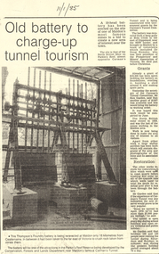
Document - LONG GULLY HISTORY GROUP COLLECTION:OLD BATTERY TO CHARGE-UP TUNNEL TOURISM
Photocopy of a newspaper article titled Old battery to charge-up tunnel tourism. There is a photo of a Thompson's Foundry battery which is being re-erected at the site of the North British mine on Parkin's Reef, near Carman's tunnel. The battery was recovered from a deep gully at Bola Creek. Other works include restoration of quartz roasting kilns and cyanide vats. Written at the top of the article is a date 11/1/85.bendigo, history, long gully history group, the long gully history group - old battery to charge-up tunnel tourism, thompson's foundry, parkin's reef reserve, conservation forests and lands department, carman's tunnel, north british mine, carman's tunnel committee, dr doug kemsley, the prospectors' and miners' association of victoria, mr ken garden -
 Bendigo Historical Society Inc.
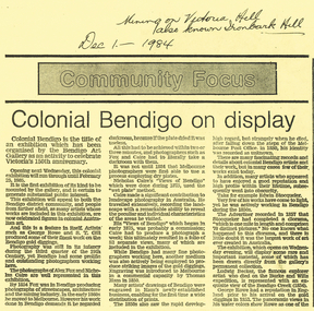
Document - LONG GULLY HISTORY GROUP COLLECTION: COLONIAL BENDIGO ON DISPLAY
Copy of an Advertiser Article titled Colonial Bendigo on display. The article mentions an exhibition organised by the Bendigo Art Gallery to celebrate Victoria's 150th anniversary. Mentioned are the artists George Rowe and S T Gill. The photographers Alex Fox and Nicholas Caire. Thomas Ham introduced engraving in a commercial capacity. Edwin Stocqueler and Ludwig Becker are also mentioned. Written above the article is: Mining on Victoria Hill, also known as Ironbark Hill. Dec 1 - 1984. On the back glass plates are mentioned. Also S T Gills water colours, lithographs and engravings. There is a photograph by Nicholas Caire, taken in 1875, showing the excavation of quartz reef and mine buildings, popper legs and chimneys near Ironbark Hill.bendigo, history, long gully history group, the long gully history group - colonial bendigo on display, bendigo art gallery, george rowe, s t gill, alex fox, nicholas caire, thomas ham, edwin stocquelerthe advertiser, ludwig becker, burke and wills, victoria hill, ironbark hill -
Bendigo Historical Society Inc.
Document - MINING IN BENDIGO COLLECTION: NOTES ON MINING IN BENDIGO
Handwritten notes on mining in Bendigo. Notes mention the size of the Bendigo Goldfield, the number of lines of reef and a brief history of goldmining in Bendigo.document, gold, mining in bendigo, mining in bendigo, notes on mining in bendigo, ravenswood sheep run, survey regiment, california hill state school, lansell's 222, mr lansell, camp hill school, high school, park mine (royal hustler's reserve no 1), memorial hall, city mine ( royal hustlers reserve no 2), mining stock exchange, beehive buildings, allan's walk, buckell & jeffrey, fortuna hustlers, great extended huatlers, garden gully united, mining exchange, garden gully united, wattle gully mine, ironbark mine, manchester arms hotel, extended hustlers mine, south belle vue, new chum railway, eureka extended, shenandoah, victoria quartz, the big 180, old chum, gt extended hustlers -
Bendigo Historical Society Inc.
Document - MINING IN BENDIGO COLLECTION: UNEARTHED QUARTZ CRUSHER
Typed notes mentioning the early pioneers of Bendigo Gold Mining. Some of them are: Messrs Ballerstedt, Wittschiebe, Luffsman, Roeder Lazarus, Kock, Hildebrandt, Bruhn,Miller, Annear, Wells, Rae,Jackson, Woodward, Sterry, Burrowes, Thorp, Heine, Holmes, Gould, Allen, Brooks, Watson and Geo Lansell. In 1911 a quartz crusher was unearthed in McCrae Street during excavations at the site of the new St.Kilian's Girls Club Rooms. It was used by the late Mr. James Irons. It was found at a depth of ten feet. Mr. Angus Kennedy, who believed that he manufactured the plant for Mr. Irons, said Mr. Irons used to crush very rich quartz from the Sheepshead Reef, south of the Big Blue Battery. Some years ago, a solid granite stone-crusher was seen at Diamond Hill. It was at the site of the old Diamond Hill Hotel. The Comet Reef was found by Mr. Driesslau, who found gold in an outcrop when he was shooting parrots. Also mentioned is the tunnel that goes right through Diamond Hill.document, gold, mining in bendigo, mining in bendigo, unearthed quartz crusher, messrs ballerstedt, wittschiebe, luffsman, roeder lazarus, kock, hildebrandt, bruhn, miller, annear, wells, rae, jackson, woodward, sterry, burrowes, thorp, heine, holmes, gould, allen, brooks, watson, geo lansell, bendigo advertiser april 28th 1911, st kilian's girls' club rooms, mr james irons, mr angus kennedy, sheepshead reef, big blue battery, diamond hill hotel, victoria proprietary ltd., comet reef, mr driesslau, diamond hill tunnel -
 Bendigo Historical Society Inc.
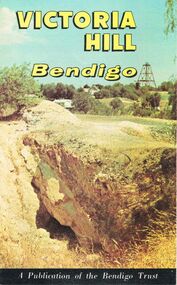
Document - JOAN O'SHEA COLLECTION: VICTORIA HILL GOLDMINING AREA BOOKLET, March 1972
Joan O'Shea Collection. Victoria Hill Bendigo Gold Mining on the Richest Quartz Reef in Bendigo, from 1854 to 1916. Colour and Black and White Booklet 16 Pages. Includes Maps of the Victoria Hill Area, photographs of the remains of a twenty head crushing battery, burnt ground from quartz roasting, The Victoria Quartz Mine Photograph from Australian Mining Standard June 1899, The compressor beds and concrete foundations for the poppet legs all that remain today of the Victoria Quartz Mine deepest mine on Bendigo Goldfield 4613 feet or 1406.04 metres. Also included photograph of the view of Victoria Hill from The New Chum Hill in the 1870s. The Location of the 3 mines Ballerstedt's open cut, North Old Chum and Lansell's 180 are marked. A depiction of Rae's Open Cut gives an understanding of the primitive nature of early workings on the Goldfields. The Booklet also provides a brief history of Victoria Hill itself.Bendigo Trust Publication March 1972. Printed in Bendigo Cambridge Press.bendigo, mining, victoria hill -
 Bendigo Historical Society Inc.
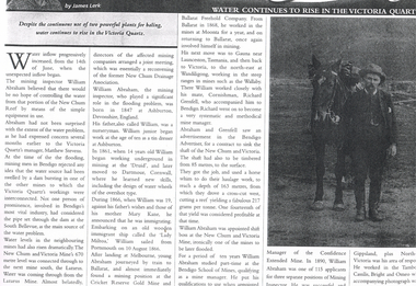
Newspaper - LONG GULLY HISTORY GROUP COLLECTION: WATER CONTINUES TO RISE IN THE VICTORIA QUARTZ
Photo of a newspaper article titled Water Continues to Rise in the Victoria Quartz by James Lerk. Article mentions William Abraham who was the mining inspector, who played a significant role in the flooding problem. Water levels had risen dramatically. Water flowed from one mine to another where they were connected. Article also mentions Abraham's birthplace, his early start to work at the age of 10 as a tin dresser at Ashburton, Devonshire, England and his working life after he migrated to Australia at the age of 19. His career in Australia is also mentioned. The article is accompanied by a photo of Abraham with his horse.bendigo, history, long gully history group, the long gully history group - water continues to rise in the victoria quartz, james lerk, william abraham, new chum reef, matthew stevens, south bellevue, new chum and victoria mine, lazarus mine, new chum drainage association, william abraham snr, mary kane, lady miltoa (ship), cricket reserve gold mine, ballarat freehold company, wallaby mine, richard grenfell, bendigo advertiser, bendigo school of mines, confidence extended mine -
Bendigo Historical Society Inc.
Document - MINING REPORTS - FOURTH COMPARTMENT INTRODUCED
Handwritten list of mines in Bendigo and Eaglehawk with the depth when the fourth compartment was introduced. Number of Shafts with fourth Compartment. Total at end of year 1908, 22, total at end of year 1909 - 42 - or an increase of 20 for the year. This is approximately 40% of all the working shafts on the year.document, gold, mining reports, mining reports, fourth compartment introduced, mines report 1909 page 117, hustlers reef no 1 park shaft, new chum goldfields, goldfields south, north, central nell gwynne, nell gwynne, goldfields consolidated, goldfields north, new bendigo goldfields propy, nell gwynne bdgo g'fields propy, goldfields extended, south concord, lansell's concord, south red white & blue, north red white & blue, victoria quartz, victoria consols, lazarus, new chum & victoria, carlisle, cornish united, united ulster, south concord, new chum railway, red, white & blue ext'd, new golden fleece, north new moon, new moon, south moon, clarence united, new argus, specimen hill, williams united, golden age (shellback shaft), johnsons no 2, confidence ext'd, callman & tachhi, needle shaft, catherine reef ext'd, bruhn's consolidated, new argus, new prince of wales -
 Bendigo Historical Society Inc.
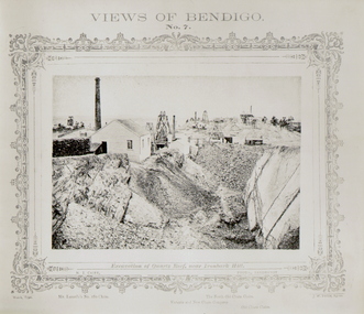
Photograph - VIEWS OF BENDIGO - QUARTZ REEF
Black and white 'Views of Bendigo' No. 7. Excavation of Quartz Reef, near Ironbark Hill. Panorama of Mullock heaps and four mine sites. Copy of frames photo?. Inscriptions: Mine sites named - 'Lansell's 180 claim', 'Victoria and New Chum Company', 'North Old Chum Claim', 'Old Chum Mine'.NJ Caire, Sandhursttopic, mining -
 Bendigo Historical Society Inc.
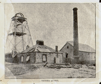
Photograph - VICTORIA QUARTZ - NEW CHUM LINE OF REEF, c.1890
Black and white photograph. Poppet head on LH side, stone building, centre, tall brick chimney, RH side in front of timber building. Inscriptions: on front - 'Victoria Quartz'. On back - typewritten description as follows: 'Situated on the rich Victoria Hill, Ironbark. Steel girders? rams type poppet legs - 60ft high. Vertical winding engines; pair of 24' dia. Winding drums. Made and erected by Roberts & Sons, Bendigo, in 1897. Then one of the best in the state. In 1910 it was the deepest gold mine in the world, having reached a depth of 4,613 ft in the winze. The shaft was then sunk to a depth of 4,588 ft. in an endeavour to reach a depth of 4,870 ft. to effectively work the deepest gold bearing reef in the world. On the night of June 14th, 1910, the mine was flooded out by the rising waters from the deep New Chum mines to the south, all of which had either ceased operations or had returned back to shallow workings. For details of the mine's record, see 'The Historical Guide to Bendigo'. Mine details completed by A Richardson, 29 Harrison Street, Bendigo.place, mining site, victoria quartz