Showing 141 items matching " victoria hill project"
-
 Tatura Irrigation & Wartime Camps Museum
Photograph, Big Eildon Project, 1953
Taken by photographer for State Rivers and Water Supply Commission.Large sepia photograph. Earthmoving equipment in right foreground and middle distance, men scattered around site working, side of hill being excavated, rounded hills beyond forming horizon.Below photo: "BIG EILDON PROJECT / Construction of Embankment across Goulburn River Bed / Work commenced November 1953." victoria state rivers and water supply commission, eildon, goulburn river -
 Cultural Historical Association of Rodriguans and Mauritians in Victoria (C.H.A.R.M Vic)
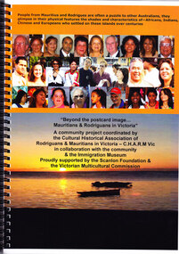
Publication, Cultural Historical Association of Rodriguans & Mauritians in Victoria, Beyond the Postcard Image...Mauritians & Rodriguans in Victoria - C.H.A.R.M Vic, 2006
This publication was published as part of a community project coordinated by C.H.A.R.M in collaboration with the community, the Immigration Museum and proudly supported by the Scanlon Foundation and the Victorian Multicultural Commission. It was produced after much time and effort had been spent researching and collating information about people who migrated to Australia from the islands of Mauritius and Rodrigues. particularly those in Victoria. Publication with faces of people from the islands of Mauritius and Rodrigues and sunset picture on the coverImmigration Museum Project - Sponsored by the Victorian Multicultural Commission and C.H.A.R.M. Vic.beyond the postcard image, community project, mauritians and rodriguans in victoria -
 Cultural Historical Association of Rodriguans and Mauritians in Victoria (C.H.A.R.M Vic)
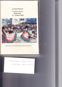
DVD, Interviews, Associations and Club Activities, Filming & production 2004
CHARM Committee members invited community members, associations and clubs to be involved in the Immigration Museum Project through sharing their personal stories and community activities on film. A number of community members, associations and clubs responded and agreed to do this.This DVD captures the personal stories of Mauritians and Rodriguans who migrated to Victoria Australia. The main aim: Research, share and preserve history through personal stories and community activitiesInterviews, filming and stories shared by community members in 2004 - Chapter 1 to Chapter 9 Running time - 87 minutesImmigration Museum Project - AV Produced by Lindsay Harris Interviews by Sabrina Lapierreimmigration, immigration museum project, migration, stories, activities, -
 Cultural Historical Association of Rodriguans and Mauritians in Victoria (C.H.A.R.M Vic)
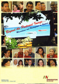
Publication, Beyond the Postcard Image.....Mauritians and Rodriguans in Victoria
Beyond the postcard image...Mauritians & Rodriguans in Victoria - Souvenir Brochure produced by the Immigration Museum for the Exhibition held at their Community Gallery from 4 Nov 2006 to 18 March 2007.Immigration Museum Project - Immigration Museum 2006. Sponsored by the Victorian Government, Victorian Multicultural Commission, Scanlon Foundation and C.H.A.R.M. Vic. -
Whitehorse Historical Society Inc.
Map, Aerial photographs Nunawading, 1972
Department of Crown Lands and Survey, Melbourne, 1972.Department of Crown Lands and Survey, Melbourne, 1972. Project runs 34 - 39 - City of Nunawading. frames numbered from South to North boundaries, each strip numbered from West to east. The series extends further West to Box Hill and East to Ringwood than the 1970 project. No index map. Sheets 39/2 and 34/28 missing.non-fictionDepartment of Crown Lands and Survey, Melbourne, 1972.victoria. department of crown lands and survey, aerial photographs, nunawading, mitcham, blackburn, blackburn north, blackburn south, forest hill, vermont, burwood east, box hill, ringwood, vermont south -
Whitehorse Historical Society Inc.
Map, Aerial photographs Nunawading, 1976
Department of Crown Lands and Survey, Melbourne, 1976 Project.Department of Crown Lands and Survey, Melbourne, 1976 Project. Runs 29 - 33 City of Nunawading. Frames numbered from South to North boundaries, each strip numbered from West to East. No index map. Sheets 30/8 and 30/9 missing.non-fictionDepartment of Crown Lands and Survey, Melbourne, 1976 Project. victoria. department of crown lands and survey, aerial photographs, nunawading, mitcham, blackburn, blackburn north, blackburn south, forest hill, vermont, vermont south, burwood east, box hill, ringwood -
 Ballarat Heritage Services
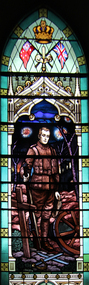
Photograph - Photograph - Colour, Former Barkly Street Uniting Church, Ballarat, 2015, 07/04/2015
The World War One windows in the Barkly Street Uniting Church resulted from a request made in 1919 from the Barkly Street Young Men's Club who raised money to pay for the project. The window was designed by the Fisher Company, and was unveiled on 14 March 1920 at a total cost of 171 pounds 10 shillings. The windows are considered to be one of the most remarkable war memorial windows in Victoria, and the 1800s English Gothic-style front facade is believed to be protected by a City of Ballarat heritage overlay. Historical experts believe the windows were designed by renowned stained-glass window-maker William Montgomery. The centre window depicts a young soldier bearing an Anzac badge underneath the British and Australian flags. The image of the solider is surrounded by 24 crosses, a single dove and a bugle. A number of colour photographs of the interior of the Barkly Street Uniting Church taken while the church was offered for sale.barkly street uniting church, barkly street methodist church, world war one, world war one memorial, stained glass, soldier, religion, church -
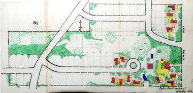 RMIT Design Archives
Work on paper - Architectural drawings, Colour plan of Lum road estate, 1970-1986
This plan of Lum Road Estate includes layout of roads, gardens, building and carparks. From 1970 until August 1971 Robin Boyd and his practice Romberg & Boyd Architects worked on designs for housing on the Lum Road Estate, Wheelers Hill. Berenice Harris, Linley Vellacott and Karl Fender drew many of the sketch plans for the project homes, while Robin Boyd drew the perspectives. This colour plan of the estate was drawn by Robin Boyd, but not signed. Frederick Romberg later annotated the drawing with details of its authorship. Colour plan of Lum road estate. Includes layout of roads, gardens, buildings and flora.Inscribed lower right on recto in black ink, 'Robin Boyd original / 12/6/86 F.R' ; Inscriber upper left on recto, grey pencil, '3400'.architecture, design, rmit design archives, domestic architecture -
Ballarat Tramway Museum
Document - Photocopy, Graeme David and Tourism Victoria, "Ballarat Tourist Tramway Proposal, Ballarat Railway Station to Sovereign Hill, Information package for development of a Feasibility Study brief - 9 Dec. 1999", Jul. 2000
Twenty three page report, doubled sided on A4 sheets, titled "Ballarat Tourist Tramway Proposal, Ballarat Railway Station to Sovereign Hill, Information package for development of a Feasibility Study brief - 9 Dec. 1999". Prepared by Graeme David, Tourism Victoria. Copy printed 23/07/00 and then photocopied for the Ballarat Trams and Transportation Steering Group. Study looks at key issues, decisions and directions to finalise scope, project issues, proposals, issues for referral, draft consultancy brief, draft route chrematistics and summary of finance figures from Harrison review. Stapled together in top left hand corner.trams, tramways, city tramway, tourism victoria, tramway revival, ballarat tramways -
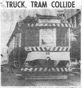 Ballarat Tramway Museum
Newspaper, Herald & Weekly Times Ltd, "Truck, tram collide", "Group charters tram", "Ballarat plans tram museum", 1971
Set of three newspaper clippings pasted onto a single sheet of paper with two Punch holes on the left hand side. First clipping from The Courier, Ballarat, 2/4/1971 with photo of tram 28 after is collision the previous day with a semi-trailer at the intersection of Princes and Victoria Streets. Gives names of the vehicle drivers and cost of the damage. Photo is of the tram returning to the depot under its own power. Tram passenger named as Margaret Foley, tram driven by James Mason and the truck driven by Gerald Winter of Gordon. See Reg Item 672.1 for a print of the Courier Photograph. Second is from The Courier, Ballarat, 15/4/1971 of the Brown Hill Progress Association chartering a tram to create interest in the project for the retention of Ballarat's trams. The tram was to leave Drummond and Sturt St. intersection the following Sunday at 1245. Item mentions the election of an interim executive and expression of interest of people outside the city. Third is from The Sun, Melbourne, 31/5/1971 about Ballarat 'tram-lovers' deciding to have a working tramway museum. Quotes Mr. Paul Nicholson, a member of the Ballarat Tramway Preservation Society. Notes that Museum will have eight trams using two miles of existing track around Lake Wendouree. Also notes that the SEC had received 88 applications for the 44 trams in both Ballarat and Bendigo.Image of the 3rd item added 28/3/2011 - see i1 and for the actual cutting i4. Original of newspaper of item 1 - also has items about the future of the railway workshops following a cost review and a story of page 1 of a submission to the Victorian Land Transport enquiry.In red ink on first cutting in top left hand corner "2/4/71" and in blue ink in top right hand corner on second cutting "15/4/71".trams, tramways, accidents, closure, charters, museum establishment -
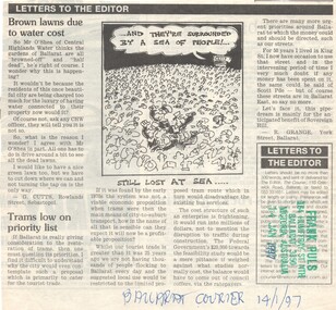 Ballarat Tramway Museum
Newspaper, R. Grange, "Trams low on the priority list", 14/01/1997 12:00:00 AM
Letter to the Editor of The Courier, Ballarat 14/1/1997 R. Grange, York St. Ballarat questioning the priorities at looking at the return of trams to Ballarat Street, against other works. Project would be mainly for the benefit of Sovereign Hill."Ballarat Courier 14/1/97" in blue ink on bottom of cutting and stamped - "Frank Puls, 164 Humffray St. Nth, Ballarat 3350, Victoria, Australia, 13 Jan. 1997" in green and blue ink.feasibility study, ballarat city tramway, ballarat revival, letter to the editor -
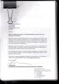 Bendigo Historical Society Inc.
Document - WHITE HILLS BOTANIC GARDENS, BENDIGO: HERITAGE SIGNIFICANCE ASSESSMENT AND STRATEGY PROJECT
Four hundred and forty three page report titled 'White Hills Botanic Gardens, Bendigo - Heritage Significance Assessment and Strategy Project by Lee Andrews & Associates Heritage Consulting, dated 31 October 2006. Contains History of White Hills Botanic Gardens, Physical Survey ad Analysis, Comparative Analysis, Analysis and Assessment of Cultural Significance, Developing the Conservation Policy, Conservation Policy, Conservation Guidelines, Conservation Actions,References and Appendices. Also contains a number of photos, copies of plans and documents, and a plan of the area with the trees marked and identified.document, white hills botanic gardens bendigo - heritage significance assessment and strategy project, bendigo historical society, jim evans, tim buykx, greater bendigo city council, lee andrews & associates heritage consulting, bendigo advertiser, the bendigonian, bendigo independent, argus, bendigo homes and property, mal gregory, mitch kemp, anthony sheean, casey ely, vicki johnson, sandra crump, friends of bendigo's botanic gardens, jane cleary, judy milner, jan orr, heritage victoria, john hawker, department of sustainability and environment historic places, norm stimson, bill dundas, janette hodgson, royal botanic gardens melbourne, roger spencer, university of melbourne burnley campus, greg moore, goldfields research centre, bendigo library, vivien newton, rita hull, state library of victoria, matheson library monash university, mueller correspondence project, sara maroske, library of the royal botanic gardens melbourne jill thurlow, helen cohn, gwen pascoe, john dwyer, larritt and russell -
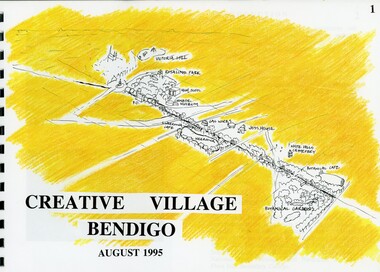 Bendigo Historical Society Inc.
Book - MERLE HALL COLLECTION: ROSALIND PARK CREATIVE VILLAGE BENDIGO PROJECT BOOK, 1995
Merle Hall Collection: Rosalind Park Creative Village Bendigo Project Book. August 1995 Book contains a description, aims of the programme and a linking plan. 35 Pages: Cover Intoduction, The Design Team, Acknowledgement Project Brief Map of Linked Park The Linking Plan described Linking plan graphic Golden Beacon Design Concept Bridge Beacon Entrance to Linear Park Gasworks Café Pavillion Gasworks layout plan Golden Beacons Concept Botanical Gardens Café Botanical Gardens layout plan Victoria Hill Interpretation Centre Victoria Hill layout Victoria Hill plan Victoria Hill continued Victoria Hill continued Rosalind Park Lookout Method 3D Road Map 3D Road Map Continued Implementation Community Participation Oppurtunities, Mosaic Works Appropriate sites Appropriate sites continued Consultaion Summary and Issues Ideas Areas for further consideration Graphic The Design Team - Grant Fink, Jane Marriott, Laszo Biro, James Brearley Graphic Layoutbook -
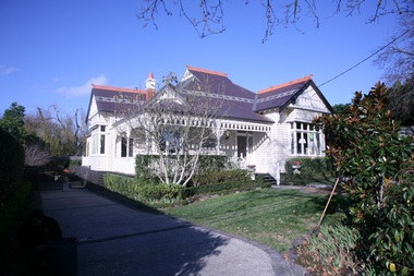
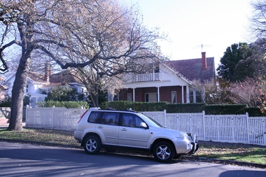
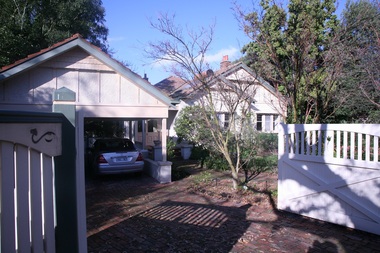
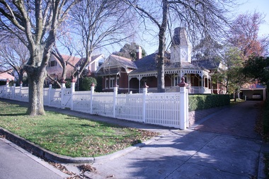
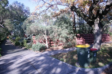
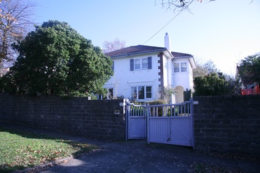
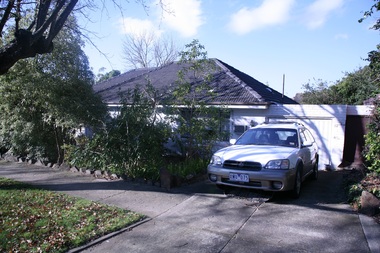
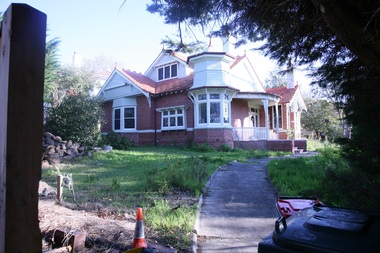
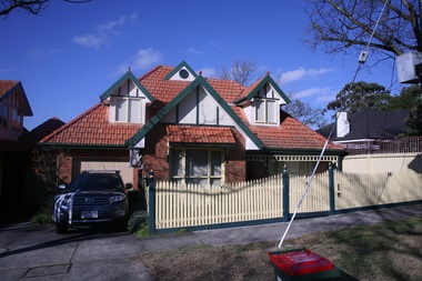
 Surrey Hills Historical Society Collection
Photograph - 5 Victoria Crescent, Mont Albert, The Street Where You Live Project
Photos documenting this address as part of a photographic series undertaken by volunteer photographers during 2013 and 2014 for The Street Where You Live Project. This was organised through the Surrey Hills Neighbourhood Centre and covered the postcode 3127 in the cities of Boroondara and Whitehorse.These photos provide a snapshot of real estate in the suburbs of Mont Albert and Surrey Hills during a period of rapid change with many properties on large blocks demolished to create higher density residential development or renewal of single dwellings. At particular risk were properties not covered by heritage overlays, in particular interwar housing and post 1950's housing. -
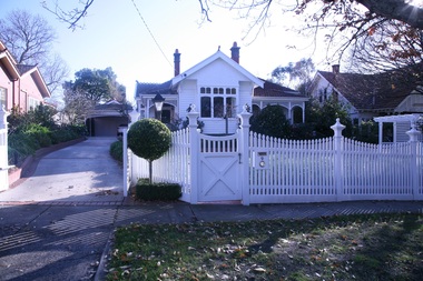
 Surrey Hills Historical Society Collection
Photograph - 6 Victoria Crescent, Mont Albert, The Street Where You Live Project
Photos documenting this address as part of a photographic series undertaken by volunteer photographers during 2013 and 2014 for The Street Where You Live Project. This was organised through the Surrey Hills Neighbourhood Centre and covered the postcode 3127 in the cities of Boroondara and Whitehorse.These photos provide a snapshot of real estate in the suburbs of Mont Albert and Surrey Hills during a period of rapid change with many properties on large blocks demolished to create higher density residential development or renewal of single dwellings. At particular risk were properties not covered by heritage overlays, in particular interwar housing and post 1950's housing. -
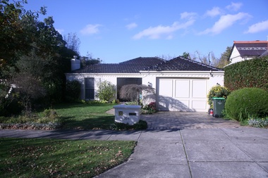
 Surrey Hills Historical Society Collection
Photograph - 7 Victoria Crescent, Mont Albert, The Street Where You Live Project
Photos documenting this address as part of a photographic series undertaken by volunteer photographers during 2013 and 2014 for The Street Where You Live Project. This was organised through the Surrey Hills Neighbourhood Centre and covered the postcode 3127 in the cities of Boroondara and Whitehorse.These photos provide a snapshot of real estate in the suburbs of Mont Albert and Surrey Hills during a period of rapid change with many properties on large blocks demolished to create higher density residential development or renewal of single dwellings. At particular risk were properties not covered by heritage overlays, in particular interwar housing and post 1950's housing. -
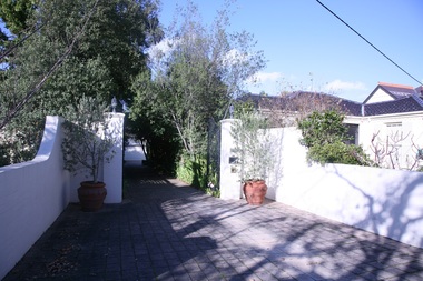
 Surrey Hills Historical Society Collection
Photograph - 8 Victoria Crescent, Mont Albert, The Street Where You Live Project
Photos documenting this address as part of a photographic series undertaken by volunteer photographers during 2013 and 2014 for The Street Where You Live Project. This was organised through the Surrey Hills Neighbourhood Centre and covered the postcode 3127 in the cities of Boroondara and Whitehorse.These photos provide a snapshot of real estate in the suburbs of Mont Albert and Surrey Hills during a period of rapid change with many properties on large blocks demolished to create higher density residential development or renewal of single dwellings. At particular risk were properties not covered by heritage overlays, in particular interwar housing and post 1950's housing. -
 Surrey Hills Historical Society Collection
Photograph - 9 Victoria Crescent, Mont Albert, The Street Where You Live Project
Photos documenting this address as part of a photographic series undertaken by volunteer photographers during 2013 and 2014 for The Street Where You Live Project. This was organised through the Surrey Hills Neighbourhood Centre and covered the postcode 3127 in the cities of Boroondara and Whitehorse.These photos provide a snapshot of real estate in the suburbs of Mont Albert and Surrey Hills during a period of rapid change with many properties on large blocks demolished to create higher density residential development or renewal of single dwellings. At particular risk were properties not covered by heritage overlays, in particular interwar housing and post 1950's housing. -
 Surrey Hills Historical Society Collection
Photograph - 10A Victoria Crescent, Mont Albert, The Street Where You Live Project
Photos documenting this address as part of a photographic series undertaken by volunteer photographers during 2013 and 2014 for The Street Where You Live Project. This was organised through the Surrey Hills Neighbourhood Centre and covered the postcode 3127 in the cities of Boroondara and Whitehorse.These photos provide a snapshot of real estate in the suburbs of Mont Albert and Surrey Hills during a period of rapid change with many properties on large blocks demolished to create higher density residential development or renewal of single dwellings. At particular risk were properties not covered by heritage overlays, in particular interwar housing and post 1950's housing. -
 Surrey Hills Historical Society Collection
Photograph - 10 Victoria Crescent, Mont Albert, The Street Where You Live Project
Photos documenting this address as part of a photographic series undertaken by volunteer photographers during 2013 and 2014 for The Street Where You Live Project. This was organised through the Surrey Hills Neighbourhood Centre and covered the postcode 3127 in the cities of Boroondara and Whitehorse.These photos provide a snapshot of real estate in the suburbs of Mont Albert and Surrey Hills during a period of rapid change with many properties on large blocks demolished to create higher density residential development or renewal of single dwellings. At particular risk were properties not covered by heritage overlays, in particular interwar housing and post 1950's housing. -
 Surrey Hills Historical Society Collection
Photograph - 11 Victoria Crescent, Mont Albert, The Street Where You Live Project
Photos documenting this address as part of a photographic series undertaken by volunteer photographers during 2013 and 2014 for The Street Where You Live Project. This was organised through the Surrey Hills Neighbourhood Centre and covered the postcode 3127 in the cities of Boroondara and Whitehorse.These photos provide a snapshot of real estate in the suburbs of Mont Albert and Surrey Hills during a period of rapid change with many properties on large blocks demolished to create higher density residential development or renewal of single dwellings. At particular risk were properties not covered by heritage overlays, in particular interwar housing and post 1950's housing. -
 Surrey Hills Historical Society Collection
Photograph - 12 Victoria Crescent, Mont Albert, The Street Where You Live Project
Photos documenting this address as part of a photographic series undertaken by volunteer photographers during 2013 and 2014 for The Street Where You Live Project. This was organised through the Surrey Hills Neighbourhood Centre and covered the postcode 3127 in the cities of Boroondara and Whitehorse.These photos provide a snapshot of real estate in the suburbs of Mont Albert and Surrey Hills during a period of rapid change with many properties on large blocks demolished to create higher density residential development or renewal of single dwellings. At particular risk were properties not covered by heritage overlays, in particular interwar housing and post 1950's housing. -
 Surrey Hills Historical Society Collection
Photograph - 13 Victoria Crescent, Mont Albert, The Street Where You Live Project
Photos documenting this address as part of a photographic series undertaken by volunteer photographers during 2013 and 2014 for The Street Where You Live Project. This was organised through the Surrey Hills Neighbourhood Centre and covered the postcode 3127 in the cities of Boroondara and Whitehorse.These photos provide a snapshot of real estate in the suburbs of Mont Albert and Surrey Hills during a period of rapid change with many properties on large blocks demolished to create higher density residential development or renewal of single dwellings. At particular risk were properties not covered by heritage overlays, in particular interwar housing and post 1950's housing. -
 Surrey Hills Historical Society Collection
Photograph - 14 Victoria Crescent, Mont Albert, The Street Where You Live Project
Photos documenting this address as part of a photographic series undertaken by volunteer photographers during 2013 and 2014 for The Street Where You Live Project. This was organised through the Surrey Hills Neighbourhood Centre and covered the postcode 3127 in the cities of Boroondara and Whitehorse.These photos provide a snapshot of real estate in the suburbs of Mont Albert and Surrey Hills during a period of rapid change with many properties on large blocks demolished to create higher density residential development or renewal of single dwellings. At particular risk were properties not covered by heritage overlays, in particular interwar housing and post 1950's housing. -
 Surrey Hills Historical Society Collection
Photograph - 15 Victoria Crescent, Mont Albert, The Street Where You Live Project
Photos documenting this address as part of a photographic series undertaken by volunteer photographers during 2013 and 2014 for The Street Where You Live Project. This was organised through the Surrey Hills Neighbourhood Centre and covered the postcode 3127 in the cities of Boroondara and Whitehorse.These photos provide a snapshot of real estate in the suburbs of Mont Albert and Surrey Hills during a period of rapid change with many properties on large blocks demolished to create higher density residential development or renewal of single dwellings. At particular risk were properties not covered by heritage overlays, in particular interwar housing and post 1950's housing. -
 Surrey Hills Historical Society Collection
Photograph - 16 Victoria Crescent, Mont Albert, The Street Where You Live Project
Photos documenting this address as part of a photographic series undertaken by volunteer photographers during 2013 and 2014 for The Street Where You Live Project. This was organised through the Surrey Hills Neighbourhood Centre and covered the postcode 3127 in the cities of Boroondara and Whitehorse.These photos provide a snapshot of real estate in the suburbs of Mont Albert and Surrey Hills during a period of rapid change with many properties on large blocks demolished to create higher density residential development or renewal of single dwellings. At particular risk were properties not covered by heritage overlays, in particular interwar housing and post 1950's housing. -
 Surrey Hills Historical Society Collection
Photograph - 17 Victoria Crescent, Mont Albert, The Street Where You Live Project
Photos documenting this address as part of a photographic series undertaken by volunteer photographers during 2013 and 2014 for The Street Where You Live Project. This was organised through the Surrey Hills Neighbourhood Centre and covered the postcode 3127 in the cities of Boroondara and Whitehorse.These photos provide a snapshot of real estate in the suburbs of Mont Albert and Surrey Hills during a period of rapid change with many properties on large blocks demolished to create higher density residential development or renewal of single dwellings. At particular risk were properties not covered by heritage overlays, in particular interwar housing and post 1950's housing. -
 Surrey Hills Historical Society Collection
Photograph - 18 Victoria Crescent, Mont Albert, The Street Where You Live Project
Photos documenting this address as part of a photographic series undertaken by volunteer photographers during 2013 and 2014 for The Street Where You Live Project. This was organised through the Surrey Hills Neighbourhood Centre and covered the postcode 3127 in the cities of Boroondara and Whitehorse.These photos provide a snapshot of real estate in the suburbs of Mont Albert and Surrey Hills during a period of rapid change with many properties on large blocks demolished to create higher density residential development or renewal of single dwellings. At particular risk were properties not covered by heritage overlays, in particular interwar housing and post 1950's housing. -
 Surrey Hills Historical Society Collection
Photograph - 20 Victoria Crescent, Mont Albert, The Street Where You Live Project
Photos documenting this address as part of a photographic series undertaken by volunteer photographers during 2013 and 2014 for The Street Where You Live Project. This was organised through the Surrey Hills Neighbourhood Centre and covered the postcode 3127 in the cities of Boroondara and Whitehorse.These photos provide a snapshot of real estate in the suburbs of Mont Albert and Surrey Hills during a period of rapid change with many properties on large blocks demolished to create higher density residential development or renewal of single dwellings. At particular risk were properties not covered by heritage overlays, in particular interwar housing and post 1950's housing. -
 Surrey Hills Historical Society Collection
Photograph - 21 Victoria Crescent, Mont Albert, The Street Where You Live Project
Photos documenting this address as part of a photographic series undertaken by volunteer photographers during 2013 and 2014 for The Street Where You Live Project. This was organised through the Surrey Hills Neighbourhood Centre and covered the postcode 3127 in the cities of Boroondara and Whitehorse.These photos provide a snapshot of real estate in the suburbs of Mont Albert and Surrey Hills during a period of rapid change with many properties on large blocks demolished to create higher density residential development or renewal of single dwellings. At particular risk were properties not covered by heritage overlays, in particular interwar housing and post 1950's housing.