Showing 85 items matching " view bend"
-
 Port Melbourne Historical & Preservation Society
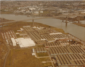
Photograph - Aerial view of West Gate Bridge under construction, 1970 - 1979
Colour aerial photograph of West Gate Bridge completed. Aircraft factory and other industry in foreground. Williamstown and fuel storage tanks in background (Coode Island)"Gov't A/C Factories Photographic Section Neg No N2841/3" stamped on backtransport, engineering, engineering - bridges, fishermans bend, industry, west gate bridge, rotten row, williamstown, yarra river -
 Port Melbourne Historical & Preservation Society
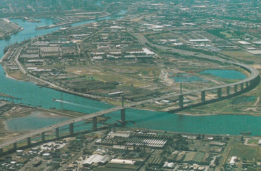
Photograph - Aerial view of West Gate Bridge, Oct 1990
... photograph of West Gate Bridge and Fishermen's Bend Photograph Aerial ...Cut from the 1990 City of Melbourne Strategy PlanPage from 1990 City of Melbourne Strategy Plan with aerial photograph of West Gate Bridge and Fishermen's Bendtown planning, engineering - bridges -
Port Melbourne Historical & Preservation Society
Photograph - Progress' mural, GMH Social Centre, Fishermen's Bend, David Thompson, 1997
Murals: Eileen Robertson, a GMH employee, was asked to do the murals in 1948 for the launching of the Holden. Her brief was to 'do something to do with transport'. In the event, they were covered anyway. She did not even view them again until 1992, around the time the murals were cleaned and restored. The left mural shows pioneer transport and on the right is the future. David Thompson photographed the Social Centre in 1997 by arrangement with member Wendy Morris archivist for GMH.From a series of black and white photos of GMH Social Centre by David Thompson: Southwest corner of hall and 'Progress' muralindustry - manufacturing, built environment, david thompson, general motors-holden, gmh -
Port Melbourne Historical & Preservation Society
Photograph - Aerial view of Yarra River and surrounds, 1990s
COPYRIGHT THE AGE Aerial photograph showing the Yarra River, Webb Dock, Port Melbourne beach, Princes pier, West Gate Bridge, Maribyrnong River, Swanston Dock and Melbourne City skyline. Taken mid 1990sStamped "Copyright. This photograph may not be reproduced without permission in writing from the Photo sales department of "the Age"'built environment - commercial, engineering - bridges, fishermans bend, natural environment - beaches and foreshore, piers and wharves - princes pier, piers and wharves - webb dock, transport - shipping, yarra river, west gate bridge, sandridge beach, maribyrnong river, swanston dock -
 Port Melbourne Historical & Preservation Society
Postcard - Aerial view of West Gate Bridge, c. 1985
... - industrial fishermans bend Colour postcard showing a photographed ...Colour postcard showing a photographed aerial view of the West Gate Bridge. Also visible is the aircraft factory and the industrial area of Fishermens Bendwest gate bridge, engineering - bridges, built environment - industrial, fishermans bend -
Port Melbourne Historical & Preservation Society
Photograph - Interior, GMH Social Centre, Fishermen's Bend, David Thompson, 1997
David Thompson photographed the cafeteria in 1997 by arrangement with member Wendy Morris archivist for GMH.From a series of black and white photos of GMH Cafeteria ('Social Centre') by David Thompson:(Entrance foyer labelled 'Social Centre' is a late addition.) Hall view to south, chairs stacked (1)industry - manufacturing, built environment, david thompson, general motors-holden, gmh -
Port Melbourne Historical & Preservation Society
Photograph - Interior, GMH Social Centre, Fishermen's Bend, David Thompson, 1997
David Thompson photographed the cafeteria in 1997 by arrangement with member Wendy Morris archivist for GMH.From a series of black and white photos of GMH Cafeteria ('Social Centre') by David Thompson:(Entrance foyer labelled 'Social Centre' is a late addition.) Hall view to south, chairs stacked (2)industry - manufacturing, built environment, david thompson, general motors-holden, gmh -
Port Melbourne Historical & Preservation Society
Photograph - Interior, GMH Social Centre, Fishermen's Bend, David Thompson, 1997
David Thompson photographed the cafeteria in 1997 by arrangement with member Wendy Morris archivist for GMH.From a series of black and white photos of GMH Cafeteria by David Thompson: Hall view to south, chairs stacked (3)industry - manufacturing, built environment, david thompson, general motors-holden, gmh -
Port Melbourne Historical & Preservation Society
Photograph - Murals, GMH Social Centre, Fishermen's Bend, David Thompson, 1997
Murals: Eileen Robertson, a GMH employee, was asked to do the murals in 1948 for the launching of the Holden. Her brief was to 'do something to do with transport'. In the event, they were covered anyway. She did not even view them again until 1992, around the time the murals were cleaned and restored. The left mural shows pioneer transport and on the right is the future. David Thompson photographed the Social Centre in 1997 by arrangement with member Wendy Morris archivist for GMH.From a series of black and white photos of GMH Social Centre by David Thompson: South end of hall showing both muralsindustry - manufacturing, built environment, david thompson, general motors-holden, gmh -
Port Melbourne Historical & Preservation Society
Photograph - Pioneer' mural, GMH Social Centre, Fishermen's Bend, David Thompson, 1997
Murals: Eileen Robertson, a GMH employee, was asked to do the murals in 1948 for the launching of the Holden. Her brief was to 'do something to do with transport'. In the event, they were covered anyway. She did not even view them again until 1992, around the time the murals were cleaned and restored. The left mural shows pioneer transport and on the right is the future. David Thompson photographed the Social Centre in 1997 by arrangement with member Wendy Morris archivist for GMH.From a series of black and white photos of GMH Social Centre by David Thompson: Southeast corner of hall and 'Pioneer' muralindustry - manufacturing, built environment, david thompson, general motors-holden, gmh -
Port Melbourne Historical & Preservation Society
Photograph - Pioneer' mural (close up), GMH Social Centre, Fishermen's Bend, David Thompson, 1997
Murals: Eileen Robertson, a GMH employee, was asked to do the murals in 1948 for the launching of the Holden. Her brief was to 'do something to do with transport'. In the event, they were covered anyway. She did not even view them again until 1992, around the time the murals were cleaned and restored. The left mural shows pioneer transport and on the right is the future. David Thompson photographed the Social Centre in 1997 by arrangement with member Wendy Morris archivist for GMH.From a series of black and white photos of GMH Social Centre by David Thompson: Southeast corner of hall and 'Pioneer' mural, close upindustry - manufacturing, built environment, david thompson, general motors-holden, gmh -
Port Melbourne Historical & Preservation Society
Photograph - Progress' mural (close up), GMH Social Centre, Fishermen's Bend, David Thompson, 1997
Murals: Eileen Robertson, a GMH employee, was asked to do the murals in 1948 for the launching of the Holden. Her brief was to 'do something to do with transport'. In the event, they were covered anyway. She did not even view them again until 1992, around the time the murals were cleaned and restored. The left mural shows pioneer transport and on the right is the future. David Thompson photographed the Social Centre in 1997 by arrangement with member Wendy Morris archivist for GMH.From a series of black and white photos of GMH Social Centre by David Thompson: Southwest corner of hall and 'Progress' mural, close up, angledindustry - manufacturing, built environment, david thompson, general motors-holden, gmh -
Port Melbourne Historical & Preservation Society
Photograph - Progress' mural (close up), GMH Social Centre, Fishermen's Bend, David Thompson, 1997
Murals: Eileen Robertson, a GMH employee, was asked to do the murals in 1948 for the launching of the Holden. Her brief was to 'do something to do with transport'. In the event, they were covered anyway. She did not even view them again until 1992, around the time the murals were cleaned and restored. The left mural shows pioneer transport and on the right is the future. David Thompson photographed the Social Centre in 1997 by arrangement with member Wendy Morris archivist for GMH.From a series of black and white photos of GMH Social Centre by David Thompson: Southwest corner of hall and 'Progress' mural, close upindustry - manufacturing, built environment, david thompson, general motors-holden, gmh -
Port Melbourne Historical & Preservation Society
Photograph - Stairway and servery, GMH Social Centre, Fishermen's Bend, David Thompson, 1997
Murals: Eileen Robertson, a GMH employee, was asked to do the murals in 1948 for the launching of the Holden. Her brief was to 'do something to do with transport'. In the event, they were covered anyway. She did not even view them again until 1992, around the time the murals were cleaned and restored. The left mural shows pioneer transport and on the right is the future. David Thompson photographed the Social Centre in 1997 by arrangement with member Wendy Morris archivist for GMH.From a series of black and white photos of GMH Social Centre by David Thompson: Southeast corner - stairway and serveryindustry - manufacturing, built environment, david thompson, general motors-holden, gmh -
Port Melbourne Historical & Preservation Society
Photograph - Interior (from balcony), GMH Social Centre, Fishermen's Bend, David Thompson, 1997
David Thompson photographed the cafeteria in 1997 by arrangement with member Wendy Morris archivist for GMH.From a series of black and white photos of GMH Cafeteria by David Thompson: View of hall to north, from balconyindustry - manufacturing, built environment, david thompson, general motors-holden, gmh -
Port Melbourne Historical & Preservation Society
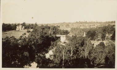
Photograph - Aerial view of the mouth of the Yarra from Williamstown, 2006
B&W aerial photographic view of the mouth of the Yarra River, taken from above Williamstown and looking east. Greenwich Bay and the cooling water outlet for Newport Power Station in the foreground, the entrance and Webb Dock in the centre, Sandridge Beach and the city upper right.piers and wharves - webb dock, yarra river, garden city, fishermans bend, newport power station -
 Port Melbourne Historical & Preservation Society
Photograph - Aerial view of first Bank Houses in Garden City, 1927
Photographic copies from black and white aerial photograph of the building of the first State Savings Bank Houses in Garden City 1927, showing also Graham Street State School, Princes Pier, Graham Street and Williamstown Road, west wing of Station Pier ("Rotomahana" at pier)built environment - domestic, fishermans bend, garden city, education - primary schools, melbourne harbor trust - port of melbourne authority, state savings bank of victoria, graham street state school, port melbourne primary school, bank houses -
Port Melbourne Historical & Preservation Society
Photograph - Aerial view of Port Melbourne, c. 1990
Notations made as a result of conversations Anne had in the early 1990's with an elderly male resident of Port Melbourne.Map and aerial photo of Port Melbourne with handwritten annotations detailing the location of various buildings, trotting tracks, etc which previously existed in Port Melbourne (recollections only).fishermans bend -
Port Melbourne Historical & Preservation Society
Photograph - Canal at Fishermen's Bend, 1886
... Bend 1886. View No 5 - General view East end - inflow of water.... of canal at Fishermen's Bend 1886. View No 5 - General view East ...View of canal at Fishermen's Bend 1886. East end - showing inflow of water, during flooding.On rear: SLTF 919.45 M48F Views of canal at Fishermen's Bend 1886. View No 5 - General view East end - inflow of water.engineering - canals and drainage -
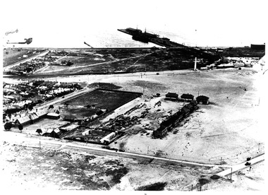
Moorabbin Air Museum
Document (item) - CAC DAP CSIRO Fishermans Bend History written by Keith Meggs Title WWII Aviation Activity from a Youthful Point of View
-
Swan Hill Regional Art Gallery
Painting, STEPHENSON, June, View from lookout, Brampton Island, Queensland, unknown
-
Swan Hill Regional Art Gallery
Drawing, HAWKE, Ronald, A view of the hills, 1979
-
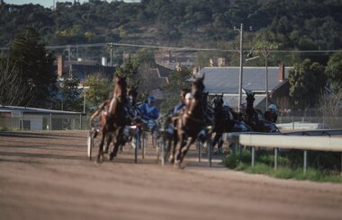 Stawell Historical Society Inc
Slide, Ian McCann, Two Around The bend
... Trotting race around the bend head on view... head on view Two Around The bend Slide Ian McCann ...Trotting race around the bend head on viewstawell trots, laidlaw park -
 Mt Dandenong & District Historical Society Inc.
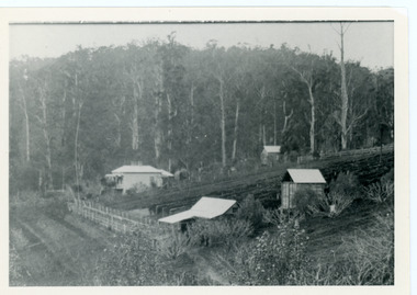
Photograph, George Barber's Home Forest Edge after 1912 Looking South West, c1912
George Barber built a homestead later named Forest Edge on Barber's Road and lived there with his wife Sarah Ann (nee Richardson).Black and white photograph showing the side view of a house and three outbuildings. Reverse of photograph has handwritten description by John Lundy-Clarke.George Barber's home on bend of Barber's Road on Lot 25, Village Settlement. Showing passionfruit plantation. Buggy shed top right. Hay shed lower right. Stables, cart shed and men's quarters lower left about 1912. Photo copied by JLC in 1973.forest edge, george barber, sarah ann barber, kalorama, barber's road -
 Mt Dandenong & District Historical Society Inc.
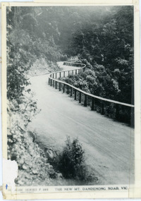
Photograph, The New Mt Dandenong Road, Vic
... View downhill from the Windy Bend showing the site of the 1972 ...Copy of Rose Series postcard #385 showing the new Mt Dandenong Tourist Road with wooden railing fence on low side of road. Surface not yet made. This photograph has a detailed inscription on the back handwritten by John Lundy-Clarke in 1974.View downhill from the Windy Bend showing the site of the 1972 landslide. In this picture the road is running along the top edge of the wall 900’ thick of Kalorama Docite that plunges thousands of feet deep down into the earth below the Ranges and extends to Fern Tree Gully. It was once a horizontal terrace nearly ten miles square and tipped over to the left when the mountain subsided into its volcanic cauldron.mt dandenong road, rose series, windy bend, landslide -
 Ballarat Tramway Museum
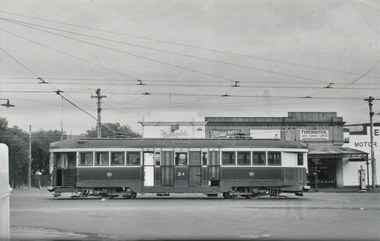
Postcard, SEC Geelong Tram No. 34
Yields information about the Melbourne N class trams and their use on Provincial systems.Black and white photograph, printed on a postcard back format of SEC Geelong Tram No. 34, side on view (later Bendigo 2) in Melbourne Road, North Geelong between Shannon St and Victoria St. Information provided by Dave O'Neil in an email to Warren Doubleday 26/11/2013 - see pdf file. Photo taken mid 1950's. Has in the background Marigold Cafe?, Minerita ?, Typewriter Sales and Service and a service station with a Shell petrol pump in view. On the rear in ink and pencil "City / N Class / HTT 20, MMTB 126, Geel 34 Bend 2"trams, tramways, geelong, melbourne road, north, tram 35 -
 Kew Historical Society Inc
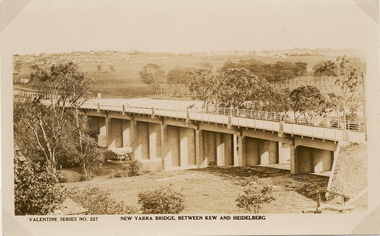
Postcard, Valentine Publishing Co Pty Ltd, New Yarra Bridge, Between Kew and Heidelberg, 1926-1930
Without bridges, Kew remained cut off from the City of Melbourne, only being accessible by Punt. Private and public bridges were constructed from the 1850s, beginning with the Hawthorn Bridge linking Bridge and Burwood Roads. A bridge across the Yarra at Burke Road was created as early as 1873. Since that first wooden bridge, a number of later bridges, typically on concrete pylons have been built, in 1926 and again during the 1970s.Angle view of the new Yarra bridge [ie. The Burke Road bridge] taken from the Kew side, showing the bridge’s structure. Trees line the river’s edge. In the distance can be seen a distant line of houses stretching to the horizon. The river appears to have an S-shaped bend beyond the bridge. The postcard, No. 227, was produced by the Valentine Publishing Co. Pty Ltd., of Queen Street, Melbourne.burke road bridge - kew (vic), bridges - kew (vic) -
 Kew Historical Society Inc
Photograph - Peel Street Health Centre : Official Opening, 1930
The North Kew Centre was the third established at North Kew. It followed a lease of a house at 50 Willsmere Road. The Peel Street building was designed by Mr Chipperfield. Messrs McIntosh and Taylor were the successful tenderers, the price being 1,240 pounds. The North Kew Baby Health Centre was finally opened on 18 June 1930 in the presence of the mayor, councillors and citizens of Kew, and representatives of the Infant Welfare Council. A report in The Age of 19 June described the opening in detail as well as the features of the new Centre. These included: "The rooms ... filled with flowers, pink and mauve hydrangeas and native heath, and the walls are adorned, with a charming frieze, representing windmills, flocks and a fairy tale goose girl. On the walls are hygiene editions of the funniest of Belloc's "Cautionary Tales" revised as posters, Outside there is promise of a gay garden, and a lovely view of green fields sloping to a shining bend of the river." Early photographic record of the opening of an early baby health centre in Kew.[Badly damaged] black and white photograph of the opening of the North Kew Baby Health Centre in Peel Street. The photo is mounted on card, and shows mothers and their children on the veranda, and officials at right. The latter includes the Mayoress and probably Vera Scantlebury. All mothers wear hats as do most of the children. [When the photograph was presented to the Society in 1979, it was described in the first Acquisitions Register as framed. Some time after that it was removed from its frame and badly broken. A separate photocopy of the original photograph is also held in the collection.]Earliest inscription: "Peel Street Health Centre / Official Opening 1930 / donated by Sr Costello and Sr Bewish [sic] 1979 / Copy purchased by ..... for Centre". Old Accession number in Texta: "KH-133 Kew Historical Society". Separate later label: "Opening North Kew Baby Health centre 1930". north kew baby health centre, peel street (kew), baby health centres - kew (vic) -
 Kew Historical Society Inc
Photograph - Victorian Canoe Club, V.C.C. site, Studley Park, 1920-30
Canoeing on the River Yarra at Melbourne was an important and widespread recreational pursuit for Melbournians, especially in the first half of the twentieth century. The Victorian Canoe Club was formed in 1912 at a meeting in Melbourne and its first committee elected in the same year. Records indicate that the Club continued into at least the 1950s .The album has historic and social significance as a record of recreational activities (as well as canoe making) in the early years of the twentieth century. It has local significance as the site of the headquarters of the Club was in Studley Park. A number of photographs in the album provide vistas of Kew on the Yarra that are otherwise unavailable.One of 24 labelled photos in part album, originating from the Victorian Canoe Club, which had its headquarters in Studley Park, Kew. The album includes a photographic record of canoe construction and also locations in Studley Park and Kew where the canoes were used. The subject of this photograph is identified as 'V.C.C. site, Studley Park'.The panoramic view shows a number of important landmarks during this period. On the left of the photograph is one of the remaining buildings of the Yarra Bend Asylum. Stretching across the river is a suspension bridge on the site of the present Kane's Bridge. The reference to the V.C.C. site is unclear within the context of the photo which appears to be taken from the vicinity of the Johnston Street Bridge."V.C.C. site, Studley Park"victorian canoe club, river yarra, canoe clubs, yarra bend asylum, suspension bridge -- kew, kane's bridge, studley park -
![Victorian Canoe Club: Pound bend tunnel [Warrandyte]](/media/collectors/550653872162f11fb04854aa/items/64e4a4b90e4970d244f1f6a1/item-media/64e4a4f30e4970d244f1fe96/item-fit-380x285.jpg) Kew Historical Society Inc
Kew Historical Society IncPhotograph - Victorian Canoe Club, Pound Bend Tunnel [Warrandyte], 1930–35
Canoeing on the River Yarra at Melbourne was an important and widespread recreational pursuit for Melbournians, especially in the first half of the twentieth century. The Victorian Canoe Club was formed in 1912 at a meeting in Melbourne and its first committee elected in the same year. Records indicate that the Club continued into at least the 1950s .The photos in this album are historically and socially significant as a record of recreational activities in the first half of the twentieth century. A number of photographs in the album provide views of sections of the Yarra, as well as areas in regional Victoria, that may otherwise be unavailable.One of 12 sepia [faded] photographs of members of the Victorian Canoe Club. This photo shows the mouth of the artificially made Pound Bend Tunnel, which was created to divert the course of the Yarra to enable gold prospecting in the river bed. "Pound Bend Tunnel"victorian canoe club, travel -- 1930s, canoeing, warrandyte, pound bend tunnel