Showing 157 items
matching wood forest
-
 Eltham District Historical Society Inc
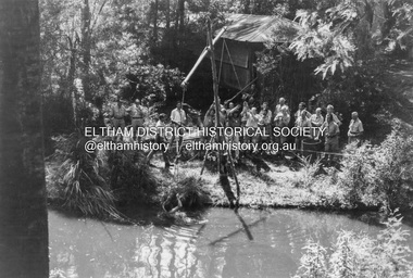
Photograph - Black and White Print, Lewis Tulk, Stage IV Scout Leader Training course, Gillwell Park, Gembrook, Vic, c.1960
Water activies at dam on site Gilwell Park is a campsite and outdoor recreation area located in Gembrook, Victoria, Australia. It is primarily used by the scouting community as a training and camping facility. The site is owned and operated by Scouts Victoria, and is one of the largest and most popular campsites in the state. It covers over 95 hectares of natural bushland, and features a range of facilities including campsites, activity areas, a dining hall, and accommodation options. Gilwell Park has a long history within the scouting movement, and is named after the original Gilwell Park located in Epping Forest, England. The English site is considered the spiritual home of scouting, and was where the first Wood Badge training course was held in 1919. Today, Gilwell Park at Gembrook offers a range of training courses and programs for scouts, leaders, and other community groups. It is also a popular destination for school camps, corporate team-building events, and outdoor enthusiasts looking to explore the natural beauty of the region. [Source: ChatGPT Open AI - Gilwell Park in Australia.. (2023, March 23). Retrieved from https://chat.openai.com/chat] Donated by Lewis Tulk, former Scout Area Training Commisioner for Leaders. Lewis did his training at Gillwell Park in London.On reverse of print, stamped with film no. 6927scouts victoria, gillwell park, gembrook, scout leader training, lewis tulk collection -
 Eltham District Historical Society Inc
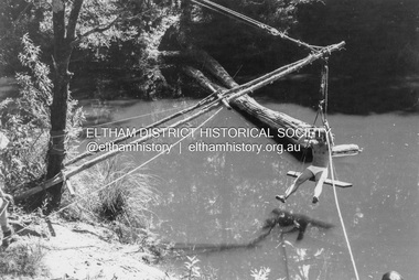
Photograph - Black and White Print, Lewis Tulk, Stage IV Scout Leader Training course, Gillwell Park, Gembrook, Vic, c.1960
Water activies at dam on site Gilwell Park is a campsite and outdoor recreation area located in Gembrook, Victoria, Australia. It is primarily used by the scouting community as a training and camping facility. The site is owned and operated by Scouts Victoria, and is one of the largest and most popular campsites in the state. It covers over 95 hectares of natural bushland, and features a range of facilities including campsites, activity areas, a dining hall, and accommodation options. Gilwell Park has a long history within the scouting movement, and is named after the original Gilwell Park located in Epping Forest, England. The English site is considered the spiritual home of scouting, and was where the first Wood Badge training course was held in 1919. Today, Gilwell Park at Gembrook offers a range of training courses and programs for scouts, leaders, and other community groups. It is also a popular destination for school camps, corporate team-building events, and outdoor enthusiasts looking to explore the natural beauty of the region. [Source: ChatGPT Open AI - Gilwell Park in Australia.. (2023, March 23). Retrieved from https://chat.openai.com/chat] Donated by Lewis Tulk, former Scout Area Training Commisioner for Leaders. Lewis did his training at Gillwell Park in London.On reverse of print, stamped with film no. 6927scouts victoria, gillwell park, gembrook, scout leader training, lewis tulk collection -
 Eltham District Historical Society Inc
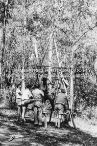
Photograph - Black and White Print, Lewis Tulk, Stage IV Scout Leader Training course, Gillwell Park, Gembrook, Vic, c.1960
Pioneering activity Gilwell Park is a campsite and outdoor recreation area located in Gembrook, Victoria, Australia. It is primarily used by the scouting community as a training and camping facility. The site is owned and operated by Scouts Victoria, and is one of the largest and most popular campsites in the state. It covers over 95 hectares of natural bushland, and features a range of facilities including campsites, activity areas, a dining hall, and accommodation options. Gilwell Park has a long history within the scouting movement, and is named after the original Gilwell Park located in Epping Forest, England. The English site is considered the spiritual home of scouting, and was where the first Wood Badge training course was held in 1919. Today, Gilwell Park at Gembrook offers a range of training courses and programs for scouts, leaders, and other community groups. It is also a popular destination for school camps, corporate team-building events, and outdoor enthusiasts looking to explore the natural beauty of the region. [Source: ChatGPT Open AI - Gilwell Park in Australia.. (2023, March 23). Retrieved from https://chat.openai.com/chat] Donated by Lewis Tulk, former Scout Area Training Commisioner for Leaders. Lewis did his training at Gillwell Park in London.On reverse of print, stamped with film no. 6927scouts victoria, gillwell park, gembrook, scout leader training, lewis tulk collection -
 Eltham District Historical Society Inc
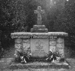
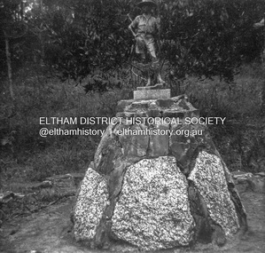
Photograph - Negative, Lewis Tulk, Outdoor Chapel, Gillwell Park, Gembrook, Vic, c.May 1957
Outdoor Chapel, Gilwell Park Scout Association State Training Centre - mainly for leaders Gilwell Park is a campsite and outdoor recreation area located in Gembrook, Victoria, Australia. It is primarily used by the scouting community as a training and camping facility. The site is owned and operated by Scouts Victoria, and is one of the largest and most popular campsites in the state. It covers over 95 hectares of natural bushland, and features a range of facilities including campsites, activity areas, a dining hall, and accommodation options. Gilwell Park has a long history within the scouting movement, and is named after the original Gilwell Park located in Epping Forest, England. The English site is considered the spiritual home of scouting, and was where the first Wood Badge training course was held in 1919. Today, Gilwell Park at Gembrook offers a range of training courses and programs for scouts, leaders, and other community groups. It is also a popular destination for school camps, corporate team-building events, and outdoor enthusiasts looking to explore the natural beauty of the region. [Source: ChatGPT Open AI - Gilwell Park in Australia.. (2023, March 23). Retrieved from https://chat.openai.com/chat] Donated by Lewis Tulk, former Scout Area Training Commisioner for Leaders. Lewis did his training at Gillwell Park in London.Print copy stamped "17" on reverselewis tulk collection, scouts victoria, gillwell park, gembrook, scout leader training -
 Eltham District Historical Society Inc
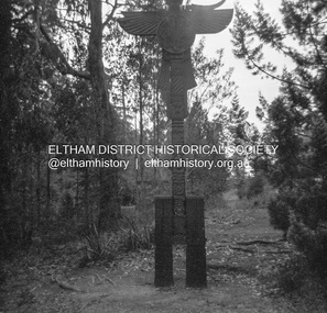
Photograph - Negative, Lewis Tulk, Outdoor Chapel, Gillwell Park, Gembrook, Vic, c.May 1957
At entrance to Chapel Outdoor Chapel, Gilwell Park Scout Association State Training Centre - mainly for leaders Gilwell Park is a campsite and outdoor recreation area located in Gembrook, Victoria, Australia. It is primarily used by the scouting community as a training and camping facility. The site is owned and operated by Scouts Victoria, and is one of the largest and most popular campsites in the state. It covers over 95 hectares of natural bushland, and features a range of facilities including campsites, activity areas, a dining hall, and accommodation options. Gilwell Park has a long history within the scouting movement, and is named after the original Gilwell Park located in Epping Forest, England. The English site is considered the spiritual home of scouting, and was where the first Wood Badge training course was held in 1919. Today, Gilwell Park at Gembrook offers a range of training courses and programs for scouts, leaders, and other community groups. It is also a popular destination for school camps, corporate team-building events, and outdoor enthusiasts looking to explore the natural beauty of the region. [Source: ChatGPT Open AI - Gilwell Park in Australia.. (2023, March 23). Retrieved from https://chat.openai.com/chat] Donated by Lewis Tulk, former Scout Area Training Commisioner for Leaders. Lewis did his training at Gillwell Park in London.Print copy stamped "17" on reverselewis tulk collection, scouts victoria, gillwell park, gembrook, scout leader training -
 Eltham District Historical Society Inc
Photograph - Negative, Lewis Tulk, Gillwell Park, Gembrook, Vic, c.May 1957
Gilwell Park is a campsite and outdoor recreation area located in Gembrook, Victoria, Australia. It is primarily used by the scouting community as a training and camping facility. The site is owned and operated by Scouts Victoria, and is one of the largest and most popular campsites in the state. It covers over 95 hectares of natural bushland, and features a range of facilities including campsites, activity areas, a dining hall, and accommodation options. Gilwell Park has a long history within the scouting movement, and is named after the original Gilwell Park located in Epping Forest, England. The English site is considered the spiritual home of scouting, and was where the first Wood Badge training course was held in 1919. Today, Gilwell Park at Gembrook offers a range of training courses and programs for scouts, leaders, and other community groups. It is also a popular destination for school camps, corporate team-building events, and outdoor enthusiasts looking to explore the natural beauty of the region. [Source: ChatGPT Open AI - Gilwell Park in Australia.. (2023, March 23). Retrieved from https://chat.openai.com/chat] Donated by Lewis Tulk, former Scout Area Training Commisioner for Leaders. Lewis did his training at Gillwell Park in London.Print copy stamped "17" on reverselewis tulk collection, scouts victoria, gillwell park, gembrook, scout leader training -
 Eltham District Historical Society Inc
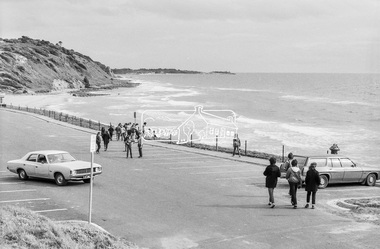
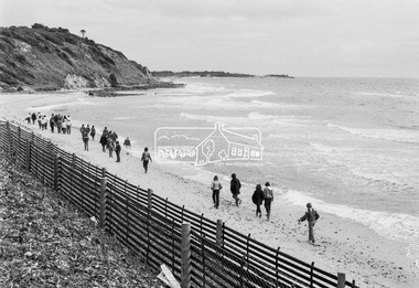
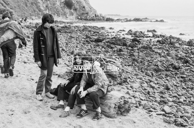
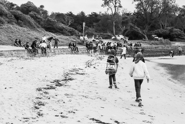
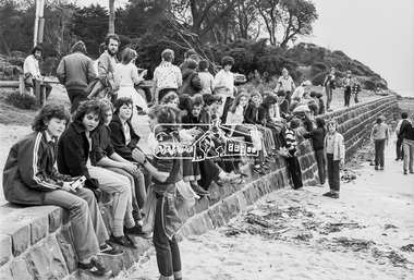
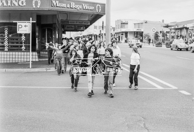
Photograph, George Coop, Sunnyside Beach, Mount Eliza, c.August 1983, 1983
Possibly an excursion or school camp for Year 8 or 9 students from Nunawading High School to the seaside at Mount Eliza. Nunawading High School opened on Canterbury Road (near Mahoneys Road) in 1955. Enrolments grew rapidly and by 1969 there were over 1,100 students, making it one of the largest schools in the state. In 1989 it was merged with Burwood Heights High and Blackburn South High to become a junior campus of Forest Hills Secondary College. However, the junior campuses were closed in 1997, and the former Nunawading High was bulldozed to make way for a housing estate. "Lost Schools of the 1990s", Learning from the Past, http://learningfromthepast.com.au/lost-schools-of-the-1990s/ George Coop was a teacher of art, craft, wood working and graphics at Nunawading High School until it merged into Forest Hills Secondary College at which point he retired.Digital TIFF file Scan of 35mm Kodak Safety 5062 black and white transparencymount eliza, nunawading high school, sunnyside beach -
 Eltham District Historical Society Inc
Photograph, George Coop, Sunnyside Beach, Mount Eliza, c.August 1983, 1983
Possibly an excursion or school camp for Year 8 or 9 students from Nunawading High School to the seaside at Mount Eliza Nunawading High School opened on Canterbury Road (near Mahoneys Road) in 1955. Enrolments grew rapidly and by 1969 there were over 1,100 students, making it one of the largest schools in the state. In 1989 it was merged with Burwood Heights High and Blackburn South High to become a junior campus of Forest Hills Secondary College. However, the junior campuses were closed in 1997, and the former Nunawading High was bulldozed to make way for a housing estate. "Lost Schools of the 1990s", Learning from the Past, http://learningfromthepast.com.au/lost-schools-of-the-1990s/ George Coop was a teacher of art, craft, wood working and graphics at Nunawading High School until it merged into Forest Hills Secondary College at which point he retired.Digital TIFF file Scan of 35mm Kodak Safety 5062 black and white transparencymount eliza, nunawading high school, sunnyside beach -
 Eltham District Historical Society Inc
Photograph, George Coop, Sunnyside Beach, Mount Eliza, c.August 1983, 1983
Possibly an excursion or school camp for Year 8 or 9 students from Nunawading High School to the seaside at Mount Eliza Nunawading High School opened on Canterbury Road (near Mahoneys Road) in 1955. Enrolments grew rapidly and by 1969 there were over 1,100 students, making it one of the largest schools in the state. In 1989 it was merged with Burwood Heights High and Blackburn South High to become a junior campus of Forest Hills Secondary College. However, the junior campuses were closed in 1997, and the former Nunawading High was bulldozed to make way for a housing estate. "Lost Schools of the 1990s", Learning from the Past, http://learningfromthepast.com.au/lost-schools-of-the-1990s/ George Coop was a teacher of art, craft, wood working and graphics at Nunawading High School until it merged into Forest Hills Secondary College at which point he retired.Digital TIFF file Scan of 35mm Kodak Safety 5062 black and white transparencymount eliza, nunawading high school -
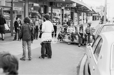
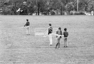
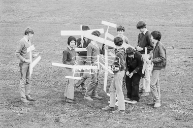
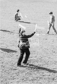
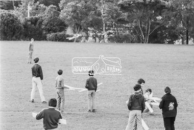
 Eltham District Historical Society Inc
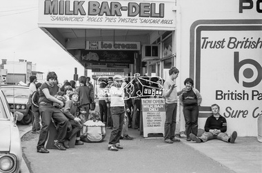
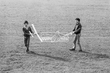
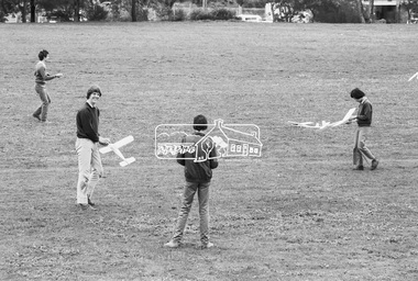
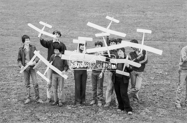
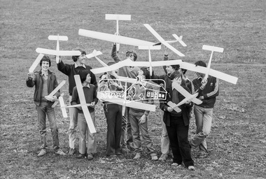
Photograph, George Coop, Balsa wood model airplane construction class, Nunawading High School, Canterbury Road, c.August 1983, 1983
Teachers at Nunawading High School were required to hold one afternoon a week with students undertaking some form of activity. There were various clubs such as gardening, chess, etc. Given George's background with art, craft and woodwork, he organised an activity for students to assemble balsa wood airplane kits which were test flown on the school grounds; Canternury Road in the background. Nunawading High School opened on Canterbury Road (near Mahoneys Road) in 1955. Enrolments grew rapidly and by 1969 there were over 1,100 students, making it one of the largest schools in the state. In 1989 it was merged with Burwood Heights High and Blackburn South High to become a junior campus of Forest Hills Secondary College. However, the junior campuses were closed in 1997, and the former Nunawading High was bulldozed to make way for a housing estate. "Lost Schools of the 1990s", Learning from the Past, http://learningfromthepast.com.au/lost-schools-of-the-1990s/ George Coop was a teacher of art, craft, wood working and graphics at Nunawading High School until it merged into Forest Hills Secondary College at which point he retired.Digital TIFF file Scan of 35mm Kodak Safety 5062 black and white transparencycanterbury road,model airplane, nunawading high school -
 Eltham District Historical Society Inc
Photograph, George Coop, Balsa wood model airplane construction class, Nunawading High School, Canterbury Road, c.August 1983, 1983
Teachers at Nunawading High School were required to hold one afternoon a week with students undertaking some form of activity. There were various clubs such as gardening, chess, etc. Given George's background with art, craft and woodwork, he organised an activity for students to assemble balsa wood airplane kits which were test flown on the school grounds; Canternury Road in the background. Nunawading High School opened on Canterbury Road (near Mahoneys Road) in 1955. Enrolments grew rapidly and by 1969 there were over 1,100 students, making it one of the largest schools in the state. In 1989 it was merged with Burwood Heights High and Blackburn South High to become a junior campus of Forest Hills Secondary College. However, the junior campuses were closed in 1997, and the former Nunawading High was bulldozed to make way for a housing estate. "Lost Schools of the 1990s", Learning from the Past, http://learningfromthepast.com.au/lost-schools-of-the-1990s/ George Coop was a teacher of art, craft, wood working and graphics at Nunawading High School until it merged into Forest Hills Secondary College at which point he retired.Digital TIFF file Scan of 35mm Kodak Safety 5062 black and white transparencycanterbury road,model airplane, nunawading high school -
 Marysville & District Historical Society
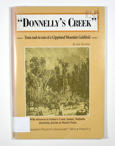
Book - Paperback book, Donnelly's Creek-From rush to ruin of a Gippsland Mountain Goldfield, 1990
A history of the Donnelly's Creek gold mine in VictoriaPaperback. Front cover has a drawing depicting two horses carrying packs followed by a man mounted on a horse. There is also two men on foot following with packs and walking poles. They are walking along a forest track that has some tree stumps alongside it.The back cover has two colour photographs. The top one is of an old wooden building with what appears to be an attached lean to. Both of the buildings have stone chimneys. There is a group of people sitting and standing outside the main building. The bottom photograph appears to be the ruins of a building and a fence. There are three people viewing the ruins.The captions accompanying the photographs are: History revisited - O'Sullivans Old Toombon Hotel Recreated and Remnants of a Bygone Mining Era.Stamp of the Marysville & District Historical Society Inc / P O Box 22 / Marysville 3779gold, gold miner, gold mining, gold field, gippsland, victoria, australia, history, fulton's creek, seaton, walhalla, aberfeldy, jericho, wood's point -
 Marysville & District Historical Society
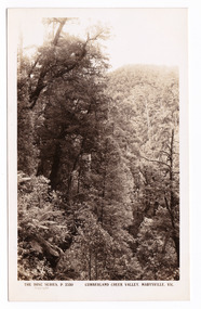
Postcard (item) - Black and white postcard, Rose Stereograph Company, Cumberland Creek Valley, Marysville, Vic, 1913-1967
A postcard in a series produced by the Rose Stereograph Company in Victoria, Australia as a souvenir of Marysville.A black and white photograph of a heavily forested valley leading up to a forested hill. The Cumberland Valley is near Cambarville which was a timber town near Marysville. Cambarville is notable for its giant mountain ash (Eucalyptus regnans) trees within the Cumberland Memorial Scenic Reserve, and relics from former sawmills and gold mining. The Big Culvert is located nearby on the Marysville - Woods Point Road, which was historically part of the Yarra Track. Cambarville was established as a timber mill town in the 1940s. Timber mill owners A Cameron and FJ Barton named Cambarville. They established the mill to salvage timber from trees destroyed in the 1939 bushfires. Cambarville was impacted by the 2009 Black Saturday bushfires and any remaining structures were destroyed.POST CARD The "Rose" Series/ De Luxe A Real Photograph/ Produced in Australia Published by the Rose Stereograph Co.,/ Armadale, Victoria.cumberland valley, marysville, victoria, p. 2330, cumberland creek, rose series postcard, postcard, souvenir, mountain ash, timber mill, mining, a cameron, fj barton, cambarville, big culvert, yarra track, black saturday bushfires, 1939 bushfires -
 Marysville & District Historical Society
Postcard (item) - Black and white postcard, Rose Stereograph Company, Cumberland Creek Valley, Marysville, Vic, 1913-1967
A postcard in a series produced by the Rose Stereograph Company in Victoria, Australia as a souvenir of Marysville.A sepia photograph of a heavily forested valley leading up to a forested hill. The Cumberland Valley is near Cambarville which was a timber town near Marysville. Cambarville is notable for its giant mountain ash (Eucalyptus regnans) trees within the Cumberland Memorial Scenic Reserve, and relics from former sawmills and gold mining. The Big Culvert is located nearby on the Marysville - Woods Point Road, which was historically part of the Yarra Track. Cambarville was established as a timber mill town in the 1940s. Timber mill owners A Cameron and FJ Barton named Cambarville. They established the mill to salvage timber from trees destroyed in the 1939 bushfires. Cambarville was impacted by the 2009 Black Saturday bushfires and any remaining structures were destroyed.POST CARD THE "ROSE"SERIES/ DE LUXE/ REAL PHOTOS PRODUCED IN/ AUSTRALIA Published by the Rose Stereographs/ Armadale, Victoriacumberland valley, marysville, victoria, p. 2330, cumberland creek, rose series postcard, postcard, souvenir, cambarville, mountain ash, mining, timber mills, big culvert, yarra track, a cameron, fj barton, black saturday bushfires, 1939 bushfires -
 Marysville & District Historical Society
Postcard (item) - Black and white postcard, Rose Stereograph Company, The Track to Cora Lynn Falls, Marysville, Vic, 1913-1967
A postcard in a series produced by the Rose Stereograph Company in Victoria, Australia as a souvenir of Marysville.A black and white photograph of the track leading through the forest to the Cora Lynn Falls which is in the Cumberland Valley in Victoria. These falls are located on the Marysville-Wood's Point Road. Cambarville is notable for its giant mountain ash (Eucalyptus regnans) trees within the Cumberland Memorial Scenic Reserve, and relics from former sawmills and gold mining. The Big Culvert is located nearby on the Marysville-Woods Point Road, which was historically part of the Yarra Track. Cambarville was established as a timber mill town in the 1940s. Timber mill owners A Cameron and FJ Barton named Cambarville. They established the mill to salvage timber from trees destroyed in the 1939 bushfires. Cambarville was impacted by the 2009 Black Saturday bushfires and any remaining structures were destroyed. THE ROSE SERIES P. 4958/ COPYRIGHT/ THE TRACK TO CORA LYNN FALLS, MARYSVILLE, VIC. The reverse of postcard is illegible as it is covered by paper residue from when postcard was removed from an album. marysville, victoria, photograph, cora lynn falls, waterfalls, p. 4958, rose series postcard, rose stereograph company, souvenir, cambarville, marysville-wood's point road, eucalyptus regnans, cumberland memorial scenic reserve, mining, big culvert, yarra track, a cameron, fj barton, 1939 bushfires, 2009 black saturday bushfires, timber mills -
 Marysville & District Historical Society
Flyer (item) - Information Flyer, Parks Victoria, park notes-Yarra Ranges National Park-Lady Talbot Drive and Cambarville Historic Township, June 2013
A flyer produced by Parks Victoria of information on Lady Talbot Drive and Cambarville Historic Township.A flyer produced by Parks Victoria of information on Lady Talbot Drive and Cambarville Historic Township. Lady Talbot Drive a 24 kilometer scenic rainforest car journey which passes a number of walks and waterfalls in the Yarra Ranges National Park. Lady Talbot Drive is named after Lady Sarah Elizabeth, the wife of Sir Reginald Talbot, who was the Governor of Victoria from 25th April, 1904 to 6th July 1908. Cambarville is notable for its giant mountain ash (Eucalyptus regnans) trees within the Cumberland Memorial Scenic Reserve, and relics from former sawmills and gold mining. The Big Culvert is located nearby on the Marysville-Woods Point Road, which was historically part of the Yarra Track. Cambarville was established as a timber mill town in the 1940s. Timber mill owners A Cameron and FJ Barton named Cambarville. They established the mill to salvage timber from trees destroyed in the 1939 bushfires. Cambarville was impacted by the 2009 Black Saturday bushfires and any remaining structures were destroyed. parks victoria, yarra ranges national park, lady talbot drive, lady talbot forest drive, cambarville, taggerty river, sir reginald talbot, lady sarah elizabeth talbot, phantom falls, keppel falls, keppel falls lookout, beeches rainforest walk, big culvert, cumberland walk, the big tree, the sitka spruce, cora lynn falls, sovereign view -
 Bendigo Military Museum
Photograph - MEMORIAL PHOTOGRAPHS, 1960's
.2) Certain it is the military cemetery in Tobruk North Africa.1) Photo , colour,framed showing "Rats of Tobruk." Memorial window" in St Johns church forest st Bendigo. Image shows a dove of Rats of Tobruk badge with the lord under frame is wood stained with gold edge. .2) Sepia colour photo showing large military cemetery.photography, photograph, religion - christian, memorials, military history -
 Marysville & District Historical Society
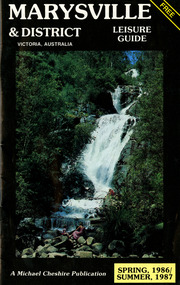
Booklet (Item) - Leisure guide, Michael Chesire & Associates Pty. Ltd, MARYSVILLE & DISTRICT LEISURE GUIDE-SPRING, 1986/SUMMBER, 1987, 1986
A free leisure guide to Marysville and the surrounding district published for Spring 1986, and Summer, 1987. This was produced by Michael Cheshire as a free publication to promote tourism in Marysville and the surrounding district. It includes maps of the Big River Valley, Cumberland Valley, Lady Talbot Forest Drive, the Marysville area, and the township of Marysville. It was released in the spring of 1986. A free leisure guide to Marysville and the surrounding district published for Spring 1986, and Summer 1987.Kilmore Historical Society *10/183 *MDL.1.marysville, victoria, australia, leisure guide, michael cheshire & associates pty ltd, marysville golf club, blackwood lodges, sir colin mackenzie fauna park, lake eildon, fraser national park, yarra valley wineries, marysville coach tours, kooringa, marylands guest house, lady talbot forest drive, wishing well, taggerty river recreation area, athols abbey, phantom falls, keppel falls, the beeches walking track, marylyn guest house, kufstein inn motel, the cumberland, marysville tourist & progress association, marysville newsagency & general store, crossways restaurant & motel, beauty spot walk, tree fern gully walk, michaeldene track, keppel track, woods lookout track, marysville hotel motel, lake mountain ski hire, marysville recreation and fun park, mytanta horseback safaris, upper big river valley, the big culvert, marysville mountain view horse hire, maryton park, amber view holiday lodges, cathedral restaurant, the top shop, tower motel, menzes garage, beauty spot nursery, marysville ski hire, lake mountain ski school, faraway forest, scenic motel, buxton trout farm, marysville hardware, timbertop steakhouse, marysville trout farm, healesville sanctuary, buxton hotel motel, nanda binya lodge, buxton antique and furniture mart, the black spur inn hotel, alexandra, lake mountain, j l gould sawmills pty. ltd., geoffrey pope & associates, marysville crafts & gifts, olde yarra track shoppe, cumberland scenic reserve, tudor lodge road house, fruit salad farm, highwayman's retreat -
 Marysville & District Historical Society
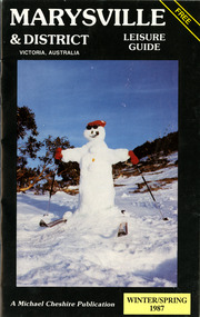
Booklet (Item) - Leisure guide, Michael Chesire & Associates Pty. Ltd, MARYSVILLE & DISTRICT LEISURE GUIDE-WINTER/SPRING 1987, 1987
A free leisure guide to Marysville and the surrounding district published for Winter and Spring, 1987. This was produced by Michael Cheshire as a free publication to promote tourism in Marysville and the surrounding district. It includes maps of the Big River Valley, Cumberland Valley, Lady Talbot Forest Drive, the Marysville area, and the township of Marysville. It was released in the winter of 1987. A free leisure guide to Marysville and the surrounding district published for Winter and Spring, 1987.marysville, victoria, australia, leisure guide, michael cheshire & associates pty ltd, marysville golf club, blackwood lodges, sir colin mackenzie fauna park, lake eildon, fraser national park, yarra valley wineries, marysville coach tours, kooringa, marylands guest house, lady talbot forest drive, wishing well, taggerty river recreation area, athols abbey, phantom falls, keppel falls, the beeches walking track, marylyn guest house, kufstein inn motel, the cumberland, marysville tourist & progress association, marysville newsagency & general store, crossways restaurant & motel, beauty spot walk, tree fern gully walk, michaeldene track, keppel track, woods lookout track, marysville hotel motel, lake mountain ski hire, marysville recreation and fun park, mytanta horseback safaris, upper big river valley, the big culvert, marysville mountain view horse hire, maryton park, amber view holiday lodges, cathedral restaurant, the top shop, tower motel, menzes garage, marysville ski hire, lake mountain ski school, faraway forest, scenic motel, buxton trout farm, marysville hardware, timbertop steakhouse, marysville trout farm, healesville sanctuary, buxton hotel motel, nanda binya lodge, buxton antique and furniture mart, the black spur inn hotel, alexandra, lake mountain, j l gould sawmills pty. ltd., geoffrey pope & associates, marysville crafts & gifts, olde yarra track shoppe, cumberland scenic reserve, tudor lodge road house, fruit salad farm, highwayman's retreat, beauty spot display gardens & nursery, ski lake mountain cross country ski hire & kitchen, buxton store, valley view marysville, acheron way, mt donna buang road, snow gum woodlands, alpine ash forests, mountain ash forests, stringybark forests, messmate forests, manna gum forests