Showing 2776 items
matching 1786-1875. | hume
-
 Lakes Entrance Historical Society
Book, Boyes, Rosemary B.E.M, The Hume Highway Today and Yesterday, 1978
Stories and photographs illustrating a little of the Hume Highway between Melbourne and AlburyCopy of inscription in Sutherland family history file.roads and streets -
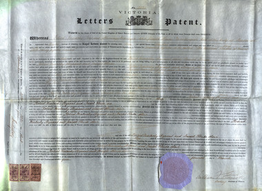 Federation University Historical Collection
Document, Letters Patent for an Invention for Roasting Pyrites, 1875, 1875
R.M. Serjeant was listed as a mining manager and Joseph Flude as a metallurgist. In 1875 they were both living in Ballarat. The patent number is A.D.1875, 4th March. No 2031. According to the patent the hearth of the furnace is in the form of a cone revolving horizontally. The feed is supplied to the apex of the cone by an archimedian screw. The crown of the furnace comprises a double covering or roof with an intermediate chamber for receiving heated air. The inner covering is pierced to admit of the heated air being brought into contact with the pyrites on the face of the revolving hearth. The discharge of the roasted substance is affected by means of a scraper at the base of the cone. It was claimed that this was a new mode of introducing heated air, and the exclusion of flame during the operation of roasting pyrites. The self-acting charge and discharge of the furnace and the peculiar construction of the hot air chambers, and the use of perforated bricks through which the supply of air is affected were also new. (http://patentsvictoria.net/002031.html) From the Goulburn Herald, 14 September 1878 "A feature connected with the school of mines is the yet unfinished pyrites works. The extraction of the gold from pyrites and the utilization for commercial purposes of other substances connected with pyrites are peculiarly important to Ballarat, because were a simple and inexpensive method devised there are millions and millions of tons of quartz that would then be made remunerative. With this thought in their minds two scientific gentlemen invented the school of mines self-acting rotatory furnace. This, for lack of funds, has not been completed as yet, but the amount in hand for the purpose is daily increasing, and it will eventually be an accomplished fact. It is in contemplation also to erect machinery shops in connection with the school, and it is purposed to con struct a steam-engine to do at once the work of the pyrites treatment and the ma chine room. A model shaft and mine too are being prepared for on the reserve, so that practical mining of the most thorough character may be taught on the ground.'Letters Patent for an Invention for Roasting Pyrites to be called 'the Ballarat School of Mines Self-Acting Pyrites Furnace' to Robert Malachy Serjeant and Joseph Flude. The large document is on a vellum type paper complete with stamps and seal. The document is signed by Acting-Governor William Stawell.Written on verso: "Date of Patent 4th March 1875 No 2031 Letters Patent for An invention for roasting pyrities to be called "The Ballarat School of Mines Self-acting Pyrities Furnace" to Robert Malachy Serjeant and Joseph Flude Melbourne, Victoriaballarat school of mines, serjeant, r.m. serjeant, robert m. serjeant, flude, joseph flude, richard gibbs, stawell, william stawell, pyrities furnace, philately, statute stamp, seal (victoria), ballarat school of mines self-acting pyrities furnace, ballarat school of mines self-acting pyrites furnace -
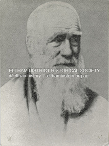 Eltham District Historical Society Inc
Photograph, Henry Dendy c.1875, 1875c
Henry Dendy (1800-1881) is best known as the founder of Brighton. It is not well known that years later he lived far longer at Eltham than he did at Brighton. In 1840 whilst still in England, he bought eight square miles of unspecified land in the Port Phillip district. This entitled him to bring a number of other people to the colony and in 1841 he arrived in Williamstown in the York with his family and 139 others. He took up this land entitlement at what is now Brighton and most of the emigrants settled there. He encountered financial problems and lost his interest in the estate in 1844. He left Brighton in 1847. He successfully not always successfully became a brewer at Geelong, a sheep farmer at Christmas Hills and Upper Moira, a flour miller at Eltham, a sheep farmer again at Werribee and finally a copper miner at Walhalla. Dendy came to Eltham in 1856 after having spent a year in England, he purchased about 5 acres of land in two parts situated each side of Maria Street (Main Road). There was a steam flour mill on that part of the land adjoining the Diamond Creek. He became prominent in local affairs serving for a time on the Eltham District Roads Board including one term as President. Dendy’s wife Sarah died at Eltham in 1860 and also in that year he was appointed Chairman of a committee to establish a Church of England in Eltham. He donated one of his Pitt Street lots for this purpose. St Margaret’s Church was opened on this site in 1861. In 1867 Dendy sold his mill to W F Ford and moved to Werribee and then Walhalla where he remained until his death. He is buried in the Walhalla cemetery. Part of the land on which the Eltham Community Reception Centre stands was the site of Dendy’s house and Mill. Some of the old trees on the site could well have been planted in Dendy’s time. Much of this information was obtained from the book “Henry Dendy and his Emigrants” by L A Schumer.Colour photograph copy of Portrait of Henry Dendy c.1875henry dendy -
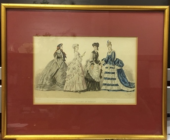 Kew Historical Society Inc
Print - Framed Fashion Plate, History of Fashion - Napoleon III 1865 to 1870, Present Fashions 1870 to 1875, c.1878
Framed fashion plate showing the 'History of Fashion' during the period 1865 to 1875.fashion plates, fashion - 1870s, french fashion -
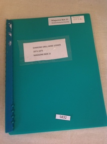 Stawell Historical Society Inc
Book, Greg Cameron, Diamond Drill Mine Ledger 1873-1875, 2005
Photocopied Ledger pages of the DIamond Drill Mine.Green Plastic Covers with Green Plastic Ring BinderDimond Drill Mine Ledger 1873 - 1875 Magazine Box 21stawell gold mining -
 Presbyterian Ladies' College, Melbourne Heritage and Archive Centre
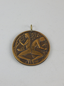
Medallion, Presbyterian Ladies' College Centenary Medallion 1875-1975, 1975
Round centenary medallion depicting two naked figures. On the reverse side are the markings P.L.C. 1875-1975This medallion has been designed by Michael Meszaros to commemorate The Centenary of The Presbyterian Ladies' College, Melbourne. The design symbolises the centenary by depicting it as a time when one looks both back at the past and forward to the future. This is illustrated in the medallion by a girl picking the fruit of the old gnarled tree - the benefits of the past, and another planting new seedlings - the plans for the future.medallion, centenary, presbyterian, ladies', college -
 Stawell Historical Society Inc
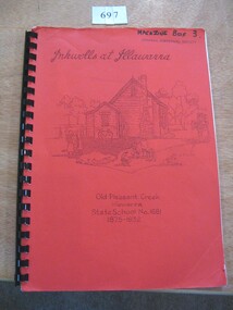
Book, John G Middleton, Inkwells at Illawarra - Old Pleasant Creek Illawarra State School No 1681 1875-1932, 1992
A History of the "Old Pleasant Creek" Illawarra State School No. 1681 compiled by John G. MiddletonRed Card cover with black plastic binding. Title is in script print with line drawing of old building and children, further print below.Inkwells at Illawarra. Old Pleasant Creek Illawarra State School No.1681 1875-1932.stawell education -
 Federation University Historical Collection
Document, Henry Richards Caselli, Annual Report Presented to the Governors and Subscribers of the School of Mines Ballarat, December 22rd 1875, 22/12/1875
Six handwritten foolscap pages of the Ballarat School of Mines Annual Report by President Henry Richards Caselli. The following attendances were recorded in 1875:- First Term - 70 Second Term - 69 Third Term - 75 Fourth Term 54 200 pounds was expended on the erecton of a large chimney stack and poison (arsenic) chambers , and in building the foundations of the furnace. henry richards caselli, ballarat school of mines, ballarat school of mines annual report -
 Kew Historical Society Inc
Map, Elizabeth Mackie, Kew 1875-1880s, c. 1985
Elizabeth Mackie was a member of the Kew Historical Society and a resident of 1 Molesworth Street. She researched and wrote the booklet 'Artists of Kew' and initiated research into authors with a connection to Kew. One of the most important maps of Kew in the KHS Collection is 'Back to Kew' created by Jesse Dannock. This water damaged map was in many places unreadable, and this re-creation by Elizabeth Mackie only included part of the original text. It was also liberally added to with pictorial symbols.A reinterpretation of the Back to Kew 1875 map created by Jesse Dannock in circa 1931. This hand-drawn map was created by Elizabeth Mackie in the 1980s.elizabeth mackie, plan of kew, maps -- kew (vic.), jesse dannock -
 Stawell Historical Society Inc
Photograph, Mr Charles Thomas Hume with his son George on the left & his son Arthur on the right from Deep Lead
Deep Lead – Portrait George Hume his father Charles Thomas Hume and Arthur Hume another son.stawell deep lead -
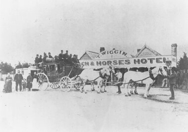 Ringwood and District Historical Society
Photograph, Original Coach and Horses Hotel, south side of Whitehorse Road, Ringwood 1875
Inscription below photograph reads, "Original Coach and Horses Hotel, Whitehorse Rd. 1875". (Thomas Wiggin) -
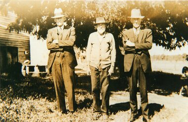
 Malmsbury Historical Society
Photograph (Item), Walter Hume (Left) And Edward Townsend Late 1930S, Malmsbury c1930s
People - "Townsend, Edward; Hume, Walter" Buildings - Malmsbury Hotel? Associated with - Hume Bros. -
 Eltham District Historical Society Inc
Photograph, Hume and Hovell Monument, Broadford, Autumn Excursion, Hume and Hovell's 1824 expedition, 26 May 1996, 26/05/1996
[article by Bettina Woodburn in EDHS Newsletter No. 109, July 1996:] ON THE TRAIL OF HUME AND HOVELL - REPORT ON THE AUTUMN EXCURSION - On a green and fresh morning (Sunday 26th May 1996) the Cobb and Co coach (driven by the most obliging Peter Tampion) set off in a north easterly direction from Eltham to connect with Hume and Hovell's route on their 1824 explorations of central Victoria. The Society would follow a series of monuments erected for the 1924 centenary of the expedition from King Parrot Creek (Tuesday 7th December 1824), through Strath Creek, over Sunday Creek (Sunday 12th December 1824) at Broadford, Tullamarine, St Albans, Deer Park, through Werribee, skirting east of the You Yangs to Lara and Avalon Beach. Because their distance-measuring wheel had broken and a one degree mistake was made in calculations, the two leaders of the original group of six convict-companions arrived at Corio Bay, instead of the expected Western Port, discovered earlier by Flinders. From below Mt. Disappointment (Hume and Hovell's difficulties in "scrambling over brush and rock", "leeches in forest, as well as no water", "cutting grass 4-5 ft. high", dreadful scrub", "devil flies") we took an easier route, saw the Strath Creek memorial in ground fog and a wonderful "field of dreams", the Hume-Hovell privately owned cricket ground with its white picket boundary fence. Now, after a steep climb, in sunshine under gums we stretched and viewed magnificent rolling hills and fog-filled valleys - not "smoke from Aborigines' bush fires". After morning tea at Broadford we followed the Sunday Creek valley beside the Hume Freeway, passed the Wallan Wallan Rest Area (more appropriately Hume and Hovell Rest Area) to tum right at Beveridge. In Gellibrand Hill Park, near the headwaters of the Moonee Ponds Creek, we experienced the landscape the first European settlers saw - huge river red gums and rolling pastures. The gardens and sheltered courtyard of the 1840s, timber, brought from .....[?] prefabricated Woodlands Homestead, provided a pleasant lunch stop. We enjoyed a private tour, panoramic views over Melbourne and surroundings and the excitement of arriving and departing aircraft. Our next river crossing was at Werribee, "in a vast treeless plain", then we drove on by-ways no coach had previously travelled, to find "an immense sheet of water" salty Corio Bay, off-course to the west. In late afternoon of a super, calm, late autumn day we headed homewards. Back at Eltham we were rather surprised to find that we had travelled a total of 347 km. Thanks again to Russell Yeoman for his research and organization. What a wonderful day! Colour photographactivities, broadford, hume and hovell, monument -
 Eltham District Historical Society Inc
Photograph, Hume and Hovell Monument, Autumn Excursion, Hume and Hovell's 1824 expedition, 26 May 1996, 26/05/1996
[article by Bettina Woodburn in EDHS Newsletter No. 109, July 1996:] ON THE TRAIL OF HUME AND HOVELL - REPORT ON THE AUTUMN EXCURSION - On a green and fresh morning (Sunday 26th May 1996) the Cobb and Co coach (driven by the most obliging Peter Tampion) set off in a north easterly direction from Eltham to connect with Hume and Hovell's route on their 1824 explorations of central Victoria. The Society would follow a series of monuments erected for the 1924 centenary of the expedition from King Parrot Creek (Tuesday 7th December 1824), through Strath Creek, over Sunday Creek (Sunday 12th December 1824) at Broadford, Tullamarine, St Albans, Deer Park, through Werribee, skirting east of the You Yangs to Lara and Avalon Beach. Because their distance-measuring wheel had broken and a one degree mistake was made in calculations, the two leaders of the original group of six convict-companions arrived at Corio Bay, instead of the expected Western Port, discovered earlier by Flinders. From below Mt. Disappointment (Hume and Hovell's difficulties in "scrambling over brush and rock", "leeches in forest, as well as no water", "cutting grass 4-5 ft. high", dreadful scrub", "devil flies") we took an easier route, saw the Strath Creek memorial in ground fog and a wonderful "field of dreams", the Hume-Hovell privately owned cricket ground with its white picket boundary fence. Now, after a steep climb, in sunshine under gums we stretched and viewed magnificent rolling hills and fog-filled valleys - not "smoke from Aborigines' bush fires". After morning tea at Broadford we followed the Sunday Creek valley beside the Hume Freeway, passed the Wallan Wallan Rest Area (more appropriately Hume and Hovell Rest Area) to tum right at Beveridge. In Gellibrand Hill Park, near the headwaters of the Moonee Ponds Creek, we experienced the landscape the first European settlers saw - huge river red gums and rolling pastures. The gardens and sheltered courtyard of the 1840s, timber, brought from .....[?] prefabricated Woodlands Homestead, provided a pleasant lunch stop. We enjoyed a private tour, panoramic views over Melbourne and surroundings and the excitement of arriving and departing aircraft. Our next river crossing was at Werribee, "in a vast treeless plain", then we drove on by-ways no coach had previously travelled, to find "an immense sheet of water" salty Corio Bay, off-course to the west. In late afternoon of a super, calm, late autumn day we headed homewards. Back at Eltham we were rather surprised to find that we had travelled a total of 347 km. Thanks again to Russell Yeoman for his research and organization. What a wonderful day! Two colour photographsactivities, hume and hovell, monument -
 Eltham District Historical Society Inc
Photograph, Hume and Hovell Monument, Broadford, Autumn Excursion, Hume and Hovell's 1824 expedition, 26 May 1996, 26/05/1996
[article by Bettina Woodburn in EDHS Newsletter No. 109, July 1996:] ON THE TRAIL OF HUME AND HOVELL - REPORT ON THE AUTUMN EXCURSION - On a green and fresh morning (Sunday 26th May 1996) the Cobb and Co coach (driven by the most obliging Peter Tampion) set off in a north easterly direction from Eltham to connect with Hume and Hovell's route on their 1824 explorations of central Victoria. The Society would follow a series of monuments erected for the 1924 centenary of the expedition from King Parrot Creek (Tuesday 7th December 1824), through Strath Creek, over Sunday Creek (Sunday 12th December 1824) at Broadford, Tullamarine, St Albans, Deer Park, through Werribee, skirting east of the You Yangs to Lara and Avalon Beach. Because their distance-measuring wheel had broken and a one degree mistake was made in calculations, the two leaders of the original group of six convict-companions arrived at Corio Bay, instead of the expected Western Port, discovered earlier by Flinders. From below Mt. Disappointment (Hume and Hovell's difficulties in "scrambling over brush and rock", "leeches in forest, as well as no water", "cutting grass 4-5 ft. high", dreadful scrub", "devil flies") we took an easier route, saw the Strath Creek memorial in ground fog and a wonderful "field of dreams", the Hume-Hovell privately owned cricket ground with its white picket boundary fence. Now, after a steep climb, in sunshine under gums we stretched and viewed magnificent rolling hills and fog-filled valleys - not "smoke from Aborigines' bush fires". After morning tea at Broadford we followed the Sunday Creek valley beside the Hume Freeway, passed the Wallan Wallan Rest Area (more appropriately Hume and Hovell Rest Area) to tum right at Beveridge. In Gellibrand Hill Park, near the headwaters of the Moonee Ponds Creek, we experienced the landscape the first European settlers saw - huge river red gums and rolling pastures. The gardens and sheltered courtyard of the 1840s, timber, brought from .....[?] prefabricated Woodlands Homestead, provided a pleasant lunch stop. We enjoyed a private tour, panoramic views over Melbourne and surroundings and the excitement of arriving and departing aircraft. Our next river crossing was at Werribee, "in a vast treeless plain", then we drove on by-ways no coach had previously travelled, to find "an immense sheet of water" salty Corio Bay, off-course to the west. In late afternoon of a super, calm, late autumn day we headed homewards. Back at Eltham we were rather surprised to find that we had travelled a total of 347 km. Thanks again to Russell Yeoman for his research and organization. What a wonderful day! Colour photographactivities, broadford, hume and hovell, monument -
 Eltham District Historical Society Inc
Photograph, Sign to Hume and Hovell Cricket Ground, at Allandale Road, Strath Creek, Autumn Excursion, Hume and Hovell's 1824 expedition, 26 May 1996, 26/05/1996
[article by Bettina Woodburn in EDHS Newsletter No. 109, July 1996:] ON THE TRAIL OF HUME AND HOVELL - REPORT ON THE AUTUMN EXCURSION - On a green and fresh morning (Sunday 26th May 1996) the Cobb and Co coach (driven by the most obliging Peter Tampion) set off in a north easterly direction from Eltham to connect with Hume and Hovell's route on their 1824 explorations of central Victoria. The Society would follow a series of monuments erected for the 1924 centenary of the expedition from King Parrot Creek (Tuesday 7th December 1824), through Strath Creek, over Sunday Creek (Sunday 12th December 1824) at Broadford, Tullamarine, St Albans, Deer Park, through Werribee, skirting east of the You Yangs to Lara and Avalon Beach. Because their distance-measuring wheel had broken and a one degree mistake was made in calculations, the two leaders of the original group of six convict-companions arrived at Corio Bay, instead of the expected Western Port, discovered earlier by Flinders. From below Mt. Disappointment (Hume and Hovell's difficulties in "scrambling over brush and rock", "leeches in forest, as well as no water", "cutting grass 4-5 ft. high", dreadful scrub", "devil flies") we took an easier route, saw the Strath Creek memorial in ground fog and a wonderful "field of dreams", the Hume-Hovell privately owned cricket ground with its white picket boundary fence. Now, after a steep climb, in sunshine under gums we stretched and viewed magnificent rolling hills and fog-filled valleys - not "smoke from Aborigines' bush fires". After morning tea at Broadford we followed the Sunday Creek valley beside the Hume Freeway, passed the Wallan Wallan Rest Area (more appropriately Hume and Hovell Rest Area) to tum right at Beveridge. In Gellibrand Hill Park, near the headwaters of the Moonee Ponds Creek, we experienced the landscape the first European settlers saw - huge river red gums and rolling pastures. The gardens and sheltered courtyard of the 1840s, timber, brought from .....[?] prefabricated Woodlands Homestead, provided a pleasant lunch stop. We enjoyed a private tour, panoramic views over Melbourne and surroundings and the excitement of arriving and departing aircraft. Our next river crossing was at Werribee, "in a vast treeless plain", then we drove on by-ways no coach had previously travelled, to find "an immense sheet of water" salty Corio Bay, off-course to the west. In late afternoon of a super, calm, late autumn day we headed homewards. Back at Eltham we were rather surprised to find that we had travelled a total of 347 km. Thanks again to Russell Yeoman for his research and organization. What a wonderful day! Colour photographactivities, hume and hovell, allandale road, strath creek -
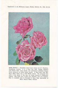 Melbourne Legacy
Pamphlet, Rose Legacy : Supplement to the Melbourne Legacy Weekly Bulletin No 1786 26/5/64, 1964
In 1964 Legacy was involved with the release of a rose that was dedicated to Legacy. It as a raised bush variety by RT Hamilton, Heidelberg. It is a deep rose pink, reliably splashed with white, large double and well-formed exhibition blooms. The proceeds of the sale of the plants were donated to Melbourne Legacy. A note in the folder of correspondence shows in 1964 over £344 was remitted to Legacy and £159 in 1965. The rose was profiled in the Legacy Bulletin on 22/9/64 and again on 12/10/65. The rose was featured on a Christmas card that was sold to promote Legacy. In 1974 a rose was released as 'Legacy Jubilee' which was a yellow with the tips of the petals suffused red. It was profiled in 'The Australian Rose Annual' and distributor Mr John Neil of 'Australian Roses' had over 2,000 plants available for sale.An example of promotional material issued by Legacy in 1964.Brochure to promote a rose bush released as Rose Legacy.legacy promotion, fundraising -
Stawell Historical Society Inc
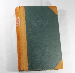
Book - Family History, The Devon Years 1440 - 1875
Plastic COver over photopaper - Sepia - Donkey in cobbled street. Colour same viewThe Devon Years 1440 - 1875: A Brief Family History Val Toomey. To Stawell Biarri Group with thanks for help given to me. Val Toomey 1999toomey, family history -
 Deaf Children Australia
Book, Minute Book 1875-1883
The minutes of each meeting of the Board of Management of the Victorian Deaf & Dumb Institution, the Victorian School for Deaf Children and Deaf Children Australia has been retained from 1862 to 2010.The minutes of the meetings provide an insight into the day to day running of the School, from Wages and Salaries, student issues to broader educational topics, building works and finances.Green fabric leather edged bound book containing the handwritten minutes of the meetings of the Victorian Deaf and Dumb Institution from Jan 1875 to Feb 1883. Committees included are: General Committee, House committee, sub-committees and special meetings.Spine: "MINUTE BOOK" in gold stamping on red leatherdeaf children australia, deaf education, minutes of meeting -
 Greensborough Historical Society
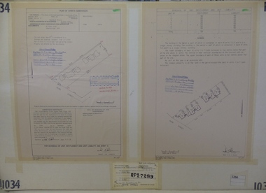
Planning Document, Subdivision Plan #1034. 50 Hume Street, 03/02/1982
Plan of Strata Subdivision at 50 Hume Street Greensborough for 7 units.An example of hard copy subdivision plans from the Greensborough area. Mainly from the Shire of Diamond Valley era (1964-1994).Plan (2 sheets) mounted on heavy card.Stamped and handwritten Council permissions, dates and other details.subdivision plan -
 Stawell Historical Society Inc
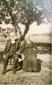
Photograph, Mr Charles Thomas Hume of Deep Lead and Mrs Thompson
Portrait Mr Charles Thomas Hume of Deep Lead and Mrs Thompsonstawell deep lead -
Beaufort Historical Society
Newspaper (Item) - Periodicals, Weekly, Riponshire Advocate April 1875
Riponshire Advocate Newspapers Published April 1875A weekly recording of news and events of interest to people in the Beaufort and surrounding areas.beaufort, ripon shire, pyrenees shire, raglan, skipton -
Beaufort Historical Society
Newspaper (Item) - Periodicals, Weekly, Riponshire Advocate June 1875
Riponshire Advocate Newspapers Published June 1875A weekly recording of news and events of interest to people in the Beaufort and surrounding areas.beaufort, ripon shire, pyrenees shire, raglan, skipton -
Beaufort Historical Society
Newspaper (Item) - Periodicals, Weekly, Riponshire Advocate July 1875
Riponshire Advocate Newspapers Published July 1875A weekly recording of news and events of interest to people in the Beaufort and surrounding areas.beaufort, ripon shire, pyrenees shire, raglan, skipton -
Beaufort Historical Society
Newspaper (Item) - Periodicals, Weekly, Riponshire Advocate May 1875
Riponshire Advocate Newspapers Published May 1875A weekly recording of news and events of interest to people in the Beaufort and surrounding areas.beaufort, ripon shire, pyrenees shire, raglan, skipton -
Beaufort Historical Society
Newspaper (Item) - Periodicals, Weekly, Riponshire Advocate August 1875
Riponshire Advocate Newspapers Published August 1875A weekly recording of news and events of interest to people in the Beaufort and surrounding areas.beaufort, ripon shire, pyrenees shire, raglan, skipton -
Beaufort Historical Society
Newspaper (Item) - Periodicals, Weekly, Riponshire Advocate September 1875
Riponshire Advocate Newspapers Published September 1875A weekly recording of news and events of interest to people in the Beaufort and surrounding areas.beaufort, ripon shire, pyrenees shire, raglan, skipton -
Beaufort Historical Society
Newspaper (Item) - Periodicals, Weekly, Riponshire Advocate November 1875
Riponshire Advocate Newspapers Published November 1875A weekly recording of news and events of interest to people in the Beaufort and surrounding areas.beaufort, ripon shire, pyrenees shire, raglan, skipton -
Beaufort Historical Society
Newspaper (Item) - Periodicals, Weekly, Riponshire Advocate October 1875
Riponshire Advocate Newspapers Published October 1875A weekly recording of news and events of interest to people in the Beaufort and surrounding areas.beaufort, ripon shire, pyrenees shire, raglan, skipton -
Beaufort Historical Society
Newspaper (Item) - Periodicals, Weekly, Riponshire Advocate December 1875
Riponshire Advocate Newspapers Published December 1875A weekly recording of news and events of interest to people in the Beaufort and surrounding areas.beaufort, ripon shire, pyrenees shire, raglan, skipton