Showing 154 items matching "aboriginal sites"
-
 Lakes Entrance Historical Society
Book, Gippsland Heritage Journal - issue 23, 1999
... Bert Boardman and Neil Macfarlane, Aboriginal historical sites... Boardman and Neil Macfarlane, Aboriginal historical sites ...This issue contains articles on the McMahon brothers voyage to Sydney by rowing boat, Dorothy Humphreys Soprano, Photographers Bert Boardman and Neil Macfarlane, Aboriginal historical sites on the Snowy river, Wilson's Promontory National Park, Crosslea Hphotography, aboriginals, ships and shipping -
Stawell Historical Society Inc
Book - History, The People of Gariwerd, The Grampians Aboriginal Hertiage, 1999
... Archaeology Rock Art Sites Aboriginal Heritage and History...Archaeology Rock Art Sites Aboriginal Heritage and History ...Archaeology Rock Art Sites Aboriginal Heritage and History Koori Brambuk Grampians Orange and Black in Colour with Photo of sun behind mountains, Hand Prints and figure. The People of Gariwerd THe Grampians Aboriginal Heritagefirst people -
 Whitehorse Historical Society Inc.
Document - Heritage Report, Rymer, Tom and Debney, Taryn, An Archaelogical Monitoring Program at Deep Creek and Loughnan Roads, Mitcham, Victoria, October 2001
... is reported to ensure that any Aboriginal and historical sites were... Extension to ensure that any Aboriginal and historical sites were ...The report on an archaeological monitoring program at Deep Creek and Loughnan Roads, Mitcham for the Eastern Freeway Extension to ensure that any Aboriginal and historical sites were suitably managed.An archaeological monitoring program at Deep Creek and Loughnan Roads, Mitcham for the Eastern Freeway Extension is reported to ensure that any Aboriginal and historical sites were suitably managed.non-fictionThe report on an archaeological monitoring program at Deep Creek and Loughnan Roads, Mitcham for the Eastern Freeway Extension to ensure that any Aboriginal and historical sites were suitably managed.deep creek road mitcham, archaeological sites, loughnan road ringwood -
 Eltham District Historical Society Inc
Book, Banyule City Council Aboriginal Heritage Study prepared by Austral Heritage Consultants, 1998 July
... A draft report on the pre-European Aboriginal achaeological... melbourne A draft report on the pre-European Aboriginal ...A draft report on the pre-European Aboriginal achaeological sites in the city of Banyule, including results of previous field surveys; Banyule covers a small part of the former lands of the Woi Wurrung. The report discusses heritage overlay, planning issues and the proposed Victorian planning provisions.100p, 30 cm.Marked "Draft"aboriginal heritage banyule, woi wurrung -
Lakes Entrance Historical Society
Photograph - Reconciliation Ceremony Lake Tyers, Lakes Post Newspaper, 1/11/1999 12:00:00 AM
... x 15 cm. Fifteen recorded sites of aboriginal massacars... x 15 cm. Fifteen recorded sites of aboriginal massacars ...Also two other colour photographs taken at the Reconciliation Ceremony at Lake Tyers numbers 04129.1 and 04129.2 size 10 x 15 cm. Fifteen recorded sites of aboriginal massacarsColour photograph of Reconciliation Ceremony at Lake Tyers Victoriaaboriginals -
Federation University Historical Collection
Document - Reports, Martin Westbrooke, Nanya Station
... Aboriginal sites have been recorded adjacent to major rivers...-group of the Barkindji. Many Aboriginal sites have been recorded ...Nanya Station, owned and managed by the University of Ballarat (now Federation University Australia), was purchased with assistance from the Department of Environment and Heritage Government Caring for our Country program. Nanya Station is located in the Scotia country, west of the Darling Ana-Branch in far western New South Wales and consists of the Nanya Western Lands Pastoral Lease 3281 – Perpetual Leasehold Lot 1244 in Deposited Plan 762778, Parish of Winnebaga, County of Tara and part of Lot 1242 County of Windeyer. Nanya is within the tribal area of the Danggali Aboriginal people, a sub-group of the Barkindji. Many Aboriginal sites have been recorded adjacent to major rivers in the region providing evidence that these areas supported a large population. The Scotia region has one of the shortest stock grazing histories of western NSW. Along with five other Scotia properties, Nanya was created as a pastoral lease in 1927. The first European settlement on the land followed exploration of the area by Sturt and Eyre. In 1854, the Lake Victoria lease which encompassed this area comprised 465,000ha.included Scotia blocks 1, 2, 3 and 4, Amoskeag and Winnebaga which formed the area known as the Scotia. It was described as a region of thick mallee scrub, interspersed with bluebush flats and Belah woodland. In the 1920s artesian water was found and the dry Scotia country was surveyed and divided into six Homestead leases allocated by ballot (Withers 1989). All properties were approximately 30,000ha, with a recommended stocking level of 3,000 sheep. Winnebaga (renamed Nanya) was taken up by Gordon Cumming. He initially dug a dam near the southeast corner of the property. A larger ground tank and rudimentary dwelling at the site of the present complex was later established. An adjacent area was cleared and cropped to provide feed for the horses used in digging the earth tanks. The ruins of the original building are located between the shearing shed and Homestead Tank. A cottage was built in the 1930s and a more substantial Red Gum framed homestead in the early 1950s. The lease was held by Mr Gordon Cumming until 1984 when it was purchased by Mr Norm Scadding as an extension to the adjacent lease, Belvedere. It was sold in 1995 to Mr Rob Taylor of Waikerie then in 1999 to BeMax Pty. Ltd., a sand mining company. These last three owners all permitted use of the property by the University for teaching and research. The Centre for Environmental Management at the University of Ballarat had been involved in studies of flora and fauna in western New South Wales since 1988. Studies became concentrated on the Scotia region with its variety of intact ecosystems due to a short pastoral history. Of particular significance is a system of natural salt lakes of which the most extensive is the Scotia Discharge Complex located on Nanya Station. An extensive vegetation survey of the Scotia region Westbrooke et al. 1998) highlighted the significance of the area both in terms of the range of communities in relatively intact condition and the occurrence of species and communities of restricted distribution. Nearly 400 species were recorded of which nine had either not previously been recorded or have restricted distribution in western NSW. Twenty-two plant communities occur on Nanya Station of which two, Halosarcia lylei low open shrubland and Hemichroa diandra/Halosarcia/Frankenia low open shrubland, are dominated by species not previously recorded from NSW. H. lylei and Acacia loderi shrublands are listed as endangered under the NSW Threatened Species Conservation Act. As noted, the area has a relatively short grazing history and, due to the presence of large areas of mallee with a Triodia understorey and restricted water supplies, stocking rates have been low. The diversity of ecosystems in relatively intact condition and extensive areas of old growth mallee made Nanya a highly significant refuge for biological diversity. This factors led to the purchase of Nanya Station by the University of Ballarat in 2004 with the assistance of the Department of Environment and Heritage for the purposes of conservation, research and education. In 2010 the southern paddocks of Nagaella Station (10,000ha.) which lie along the northern boundary, were purchased with the assistance of Lower Murray Darling Catchment Management Authority and added to the Nanya lease to provide complete protection for the communities of the Nanya Discharge Complex and further high quality Malleefowl habitat. Four digital reports documents relating to Federation University's Nanya Station, Western New South Walesnanya station, scotia country, pastoral lease, winnebaga county, darling ana-branch, martin westbrooke, environmental education, nagaella station, lower murray darling catchment management authority, conservation research education, ian gribble, pat prevett, ian henderson, danggali -
 The Beechworth Burke Museum
Geological specimen - Slate with Iron pyrites
This specimen was recovered from Moonambel, Donkey Hill, Victoria. Established in the early 1860's, Moonambel is a small town in the Pyrenees region of the Australian state of Victoria. In the 1850s the location of Moonambel was part of the ‘Mountain Creek’ pastoral run, but in 1860 reports began to appear of a gold-rush at McKinnon’s ‘Mountain Creek’ station. By 1861, a township had developed on the diggings site, and on 21 October 1861 the “municipal district of Moonambel, on Mountain Creek” was proclaimed. The name 'Moonambel' is believed to be an aboriginal word meaning 'hollow in the hills'. Slate is a stone with a fine grain that is noted for its persistent strength and ability to naturally split into slabs. It forms under low temperatures and is most often created from clay. Pyrite is a crystallising compound that occurs naturally in grey and blue-black slate that is colloquially referred to as slate-rust as it resembles regular rust. This specimen is part of a larger collection of geological and mineral specimens collected from around Australia (and some parts of the world) and donated to the Burke Museum between 1868-1880. A large percentage of these specimens were collected in Victoria as part of the Geological Survey of Victoria that begun in 1852 (in response to the Gold Rush) to study and map the geology of Victoria. Collecting geological specimens was an important part of mapping and understanding the scientific makeup of the earth. Many of these specimens were sent to research and collecting organisations across Australia, including the Burke Museum, to educate and encourage further study.Pyrite is iron sulphide (also known as “fool's gold”) which is commonly found in slates.Existing label: 53 /moonambel, slate, pyrite, burke museum, beechworth, indigo shire, beechworth museum, geological, geological specimen, mineralogy, victoria -
 Orbost & District Historical Society
book, A History of the Aboriginal people of East Gippsland by Kym Thompson, January, 1985
A manuscript book with a pink cover. A History of the Aboriginal People of East Gippsland by Kym Thompson. It is a report for the Land Conservation Council, Victoria, 1985. Contains archaeological research, history of white invasion and matters related to the preservation of sites of significance in the area. 284pp.book australian-aborigines land-conservation-council thompson-kym -
 Orbost & District Historical Society
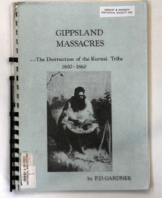
book, Gardner, Peter, Gippsland Massacres, 1983
... , as well as other massacre sites. Aboriginal-history-East-Gippsland ...This is an early European history of the region that saw the population of the Kurnai tribes plummet from 3000 to less than 300 in twenty years. Gardner examines the details of five major massacres of Aboriginals that occurred in Gippsland before 1852, as well as other massacre sites.A spiral bound book titled "Gippsland Massacres" written by Peter Gardner, The Destruction of the Kurnai Tribe 1800-1860. It has a pale blue cover with black text and a photo of a seated Aborigine. it has 113 pp.aboriginal-history-east-gippsland kurnai massacres -
 Orbost & District Historical Society
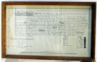
framed document, Batman's Melbourne Deed, 1966
The Batman Deed is sometimes called the Batman Treaty, the Dutigullar Deed, the Dutigullar Treaty or the Melbourne Deed. The deeds had been drafted by JT Gellibrand, a leading lawyer in the colony. Batman's Treaty was a document signed on 6 June 1835 by John Batman, an Australian grazier, businessman and explorer, and a group of Wurundjeri elders, for the purchase of land around Port Phillip, near the present site of the city of Melbourne. The document came to be known as Batman's Treaty and is considered significant as it was the first and only documented time when Europeans negotiated their presence and occupation of Aboriginal lands directly with the traditional owners. The so-called treaty was implicitly declared void on 26 August 1835 by the Governor of New South Wales, Richard Bourke. The original Batman Deed is of enormous significance to the history of the European settlement of Victoria. Framed print of the Batman Deed, dated 1835. This is a printed copy of the Batman Deed, made in 1966 from the 'original' by the State Library of Victoria. The frame is wood. The document consists of handwritten text in black ink with eight signatures in the lower right hand side and three signatures in the lower left hand corner. It has been signed by John Batman beneath the eight signatures.document batman-deed melbourne -
 Orbost & District Historical Society
boomerang
Inspected by Joanna Freslov, archaeologist 2/6/2008. Hunting boomerangs were used by the Australian Aboriginals, mainly for injuring or killing animals or enemies. Hunting boomerangs fly at high speed close to the ground and can easily kill a small animal or knock down a larger one. As well these boomerangs were used as hand-held weapons, as musical instruments and for sport. Some of the other uses were, religious ceremonies, digging, clearing fire sites, unearthing ants and lizards. Hunting boomerangs are normally made from the curving roots of trees. (ref. boomerangshack)The necessary tools and equipment for hunting, fishing and warfare were one of the very few items that Aboriginals carried with them from place to place. Most were used for a multiplicity of purposes. Because many were made from raw natural materials, such as wood, generally only partial remains are found today. this item is an example of a hunting boomerang used by early Indigenous people in the Northern Territory.A hand carved hooked boomerang of a deep red wood. Possibly used for fighting.boomerang aboriginal hunting weapon -
 Orbost & District Historical Society
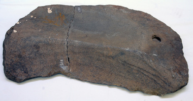
grindstone
Inspected by Joanna Freslov, archaeologist 2.6.22008. Grinding stones are slabs of stone that Aboriginal people used to grind and crush different materials. Bulbs, berries, seeds, insects and many other things were ground between a large lower stone and a smaller upper stone. This is the lower stone.Large grinding stones such as this one were designed to be left at a camp site for use the next time the group moved there. Smaller grinding stones were carried between sites. Grinding stones were not abandoned when they became worn and smooth through use. The stone would simply be roughened again so it was once again suitable for its function. This is an example of a food preparation utensil used by the Early Indigenous people of Eastern Australia.A large flat rock with grind hole in top. Rock has split. gridstone aboriginal stone-artefact -
 Warrnambool and District Historical Society Inc.
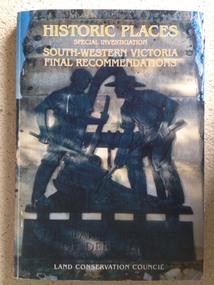
Book, Historic Places of South West Victoria
This is the third in a series of booklets produced by the Land Conservation Council in 1997 (176 pages). Booklets One and Two (1996) contained A Descriptive Report and Proposed Recommendations. The Final Recommendations include information on processes for protection of historic places, lists of significant places in the south-western region and aboriginal historic places. Attached inside the back cover are two maps showing the location of the significant places.This is a useful book as it lists the declared historic sites in the region and researchers will find the information helpful. This is a soft-cover book with a multi-coloured cover featuring a photograph of the Pioneers Memorial, Deep Lead. It has a red-coloured spine and back cover.Front Cover – Historic Places - Special Investigation - South-Western Victoria - Final Recommendations – Land Conservation Council Spine – Historic Places – South-Western Victoria – Final Recommendations – Land Conservation Council Back Cover – Historic Places, Final Rec., code used for retail sales warrnambool -
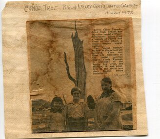 Kiewa Valley Historical Society
Newspaper clipping 11/7/72 Canoe tree in Kiewa & Photo-Tawonga Homestead
1. Kiewa Valley Consolidated School was established in 1953 combining Dederang North, Kergunyah, Gundowring, Kiewa, Gundowring Upper, Red Bluff, Charleroi and Gundowing North schools on a 10 acre site with 11 rooms at Kiewa. The bark was cut from the canoe tree, by aboriginal craftsmen, to produce a canoe for fishing in the rivers running through the Kiewa Valley either before or just after the 1800's. The tree trunk, located at Kiewa, would have been used at the beginning of European settlement in the Kiewa Valley or just before contact was made. 2. Pictorial record of the graves of early pioneers C Ibbotson, Mrs Elizabeth Eyre and John Eyre who died between 1858 – 1904, all located at Tawonga Homestead 1. The above schools are in the Kiewa Valley. The date and number of combined schools give insight into the change in population and families in the Kiewa Valley before and after 1953. The tree was found along the Kiewa River and indicates that Aborigines lived by the river and used tree bark to craft canoes to cross rivers and to fish in the deeper sections of the river. 2. Pictorial record of the early history of Kiewa Valley pioneers whose descendants have lived and worked in the Kiewa Valley for many years 1. Newspaper article of local school children visiting a canoe tree in Kiewa July 11, 1972. mounted on buff card 2. Black and white photo of pioneer graves at old Tawonga Homestead. Mounted on buff card 1. Handwritten in black ink above newspaper clipping ‘Canoe Tree Kiewa Valley Consolidated School. 11 July, 1972’ Handwritten in pencil at bottom of article ’10 Nov. ‘72’ 2. Handwritten in black ink above photo ‘Tawonga Homestead graves’ Handwritten below photo ‘T Ibbotson D. 1858, Elizabeth Eyre D. 1879, John Eyre D 1879, John Eyre D. 1904 tawonga homestead, canoe tree at kiewa, tawonga graves -
 Warrnambool and District Historical Society Inc.
Document (Sketch Plan of Dunmore), Stan Baulch, 1972
... for bread making, the croquet lawn, the site of the aboriginal mia... making, the croquet lawn, the site of the aboriginal mia mias ...This card has a sketch map showing the properties surrounding Dunmore on one side and a detailed sketch plan of Dunmore homestead in the early 1970s on the other side. The plan of Dunmore homestead shows interesting features such as the brick oven for bread making, the croquet lawn, the site of the aboriginal mia mias, the Turkish baths and the fowl house used later as a poison house. Francis and Ann Baulch were pioneer settlers in the Kirkstall area and their son Samuel worked at Dunmore in the Macarthur area before purchasing in the early 1870s the property he named Rose Park. In the 1890s he acquired property in the Dunmore estate and his son Stan Baulch gained a section of the Dunmore property after his father’s death. Stan Baulch named this Dunmore section, Rose Park, a property to the west of his father’s original Rose Park property. Stan Baulch was a long time member of the Warrnambool & District Historical Society and he contributed many local history articles and donated many local artefacts to the Society.This sketch plan is of interest as it tells us what the historic homestead of Dunmore in Western Victoria was like in the early 1970s. It will be useful for research. This is a sheet of white lightweight cardboard with a pencilled sketch on one side and a blue ink sketch plan of a house on the other side. The edges of the card have some torn sections. The card is enclosed in an oval cardboard cylinder (recycled and torn at the ends). Both the card and the cover have handwritten titles in ink. Dunmore Homestead & History by S. Baulch Dunmore Homestead drawn by Stan Baulch c.1972 dunmore property, western victoria, baulch family -
 Eltham District Historical Society Inc
Photograph, Fay Bridge, Ancient Eel trap on the Yarra River at Laughing Waters, Eltham - pre-dating European settlement, 6 September 2023
Laughing Waters is the name for a stretch of the Yarra Valley Parklands consisting of river flats and hilly riparian bushland. With Birrarung (Yarra River) flowing through, Laughing Waters has been an important gathering place for thousands of years. For the Wurundjeri, ‘Garambi Baan’ (the name for Laughing Waters in Woi wurrung) is an important site for growing and harvesting food. Significantly, Wurundjeri iuk (eel) traps remain at Garambi Baan to this day. The Wurundjeri Woi Wurrung People take their name from the Woi wurrung language word ‘wurun’ meaning the Manna Gum (Eucalyptus viminalis) which is common along ‘Birrarung’ (Yarra River), and ‘djeri’, the grub which is found in or near the tree. Wurundjeri are the ‘Manna Gum People’ and their Ancestors have lived on this land for millennia. The site on the Yarra River near the former Morrison property Killeavey was given a language name in 2015 at the instigation of Wurundjeri Elder, Dave Wandin. Garambi Baan means “laughing waters” in the traditional language, Woi wurrung. The site at Warrandyte was rediscovered by Campbell Beardsell OAM in 2007 and is one of only a few known remaining iuk (eel) traps on Country once found the length of the Birrarung (Yarra) and the Maribyrnong. Original Indigenous aquacultural infrastructure was dismantled, taken away from sites and used to build houses, fords and roads by Europeans. The difficult and restricted access to this site is thought to be one of the reasons for its survival. The iuk trap is located within lands managed by Parks Victoria. The Narrap team in partnership with Parks Victoria and Acacia Land Management have been improving the native vegetation with a program of woody weed removal, exclusion fencing and revegetation. Importantly, the team have restored the trap’s infrastructure and have demonstrated its effectiveness.” References: Wurundjeri Woi Wurrung Cultural Heritage Aboriginal Corporation - Laughing Waters. (2023, September 3). Retrieved from https://inplace.org.au/laughing-waters/ GARAMBI BAAN LAUGHING WATERS RESIDENCY CENTRE 2020 2024 Strategic Plan, Nillumbik Shire Council (2023, September 3). Retrieved from https://www.nillumbik.vic.gov.au/files/assets/public/minutes-and-agendas/2020/09-sep/15-sep-cm/ocm.177-20-attachment-1-laughing-waters-arts-program_1.pdffay bridge collection, eel trap, laughing waters, yarra river, wurundjeri woi wurrung, garambi baan, 2023-09-06 -
 Eltham District Historical Society Inc
Photograph - Digital Photograph, Alan King, Manna Gums at the Gawa Wurundjeri Aboriginal Resource Trail, 28 December 2007
Manna Gum is a species of a small to a very tall tree that is endemic to south-eastern Australia. These particular trees are part of the Gawa Wurundjeri Resource Trail at Watsons Creek. Signs share information about how the Wurundjeri people lived near the creek and used the land to obtain bush foods, medicines, tools, shelter and clothes. The trail introduces visitors to the indigenous flora and fauna, including manna gums, Lomandra (used to weave baskets) and wombat burrows. Published: Nillumbik Now and Then / Marguerite Marshall 2008; photographs Alan King with Marguerite Marshall.; p3This collection of almost 130 photos about places and people within the Shire of Nillumbik, an urban and rural municipality in Melbourne's north, contributes to an understanding of the history of the Shire. Published in 2008 immediately prior to the Black Saturday bushfires of February 7, 2009, it documents sites that were impacted, and in some cases destroyed by the fires. It includes photographs taken especially for the publication, creating a unique time capsule representing the Shire in the early 21st century. It remains the most recent comprehenesive publication devoted to the Shire's history connecting local residents to the past. nillumbik now and then (marshall-king) collection, gawa wurundjeri aboriginal resource trail, manna gums, watsons creek -
 Eltham District Historical Society Inc
Photograph, Fay Bridge, Ancient Eel trap on the Yarra River at Laughing Waters, Eltham - pre-dating European settlement, 16 May 2015
Laughing Waters is the name for a stretch of the Yarra Valley Parklands consisting of river flats and hilly riparian bushland. With Birrarung (Yarra River) flowing through, Laughing Waters has been an important gathering place for thousands of years. For the Wurundjeri, ‘Garambi Baan’ (the name for Laughing Waters in Woi wurrung) is an important site for growing and harvesting food. Significantly, Wurundjeri iuk (eel) traps remain at Garambi Baan to this day. The Wurundjeri Woi Wurrung People take their name from the Woi wurrung language word ‘wurun’ meaning the Manna Gum (Eucalyptus viminalis) which is common along ‘Birrarung’ (Yarra River), and ‘djeri’, the grub which is found in or near the tree. Wurundjeri are the ‘Manna Gum People’ and their Ancestors have lived on this land for millennia. The site on the Yarra River near the former Morrison property Killeavey was given a language name in 2015 at the instigation of Wurundjeri Elder, Dave Wandin. Garambi Baan means “laughing waters” in the traditional language, Woi wurrung. The site at Warrandyte was rediscovered by Campbell Beardsell OAM in 2007 and is one of only a few known remaining iuk (eel) traps on Country once found the length of the Birrarung (Yarra) and the Maribyrnong. Original Indigenous aquacultural infrastructure was dismantled, taken away from sites and used to build houses, fords and roads by Europeans. The difficult and restricted access to this site is thought to be one of the reasons for its survival. The iuk trap is located within lands managed by Parks Victoria. The Narrap team in partnership with Parks Victoria and Acacia Land Management have been improving the native vegetation with a program of woody weed removal, exclusion fencing and revegetation. Importantly, the team have restored the trap’s infrastructure and have demonstrated its effectiveness.” References: Wurundjeri Woi Wurrung Cultural Heritage Aboriginal Corporation - Laughing Waters. (2023, September 3). Retrieved from https://inplace.org.au/laughing-waters/ GARAMBI BAAN LAUGHING WATERS RESIDENCY CENTRE 2020 2024 Strategic Plan, Nillumbik Shire Council (2023, September 3). Retrieved from https://www.nillumbik.vic.gov.au/files/assets/public/minutes-and-agendas/2020/09-sep/15-sep-cm/ocm.177-20-attachment-1-laughing-waters-arts-program_1.pdffay bridge collection, 2015-05-16, eel trap, laughing waters, yarra river, wurundjeri woi wurrung, garambi baan -
Federation University Historical Collection
Book - Book - Scrapbook, Ballarat School of MInes: Scrapbook of Newspaper Cuttings, Book 70, July 1995 to September 1995
Collection of newspaper articles related to Ballarat School Of Mines.They cover activities and advertisements for staff. The papers concerned are The Courier, Ballarat, The Australian, The Age ad other region papers over the period of 13 May 1995 to 30 June 1995.Book with yellow cover, front, spiral bound. teaching positions advertised, pre-employment courses, courses available, enrolment for smb courses, smb recognises achievements, sharon boyd, anne-marie vance, julie hayter, ellimatta exhibition, b&w photo exhibition of aboriginal community since 1850s, music theatre institute plan, vacant sacred heart site, ub new engineering course launched, dennis else, budding builders, folio workshop, courses take mystery out of computers, ararat tafe funding, workskill awards, melissa cameron, clinton miller, stephen flood, aaron mercer, dan daly, luke stevens, focus on tafe colleges, disabled out to improve services, smb and box hill co-operate, smb helps neighbourhood house, geoff mainwarring, painting a picture of the war, v-p day, playhouse-disabled children program, rockie morris awards, farewell to ararat technical school, ruth zegir master builders association apprentice of the year, ballarat university open day, new craftsmen recognised, associate diploma of ceramics, smb development starts, paul hutchison graduates, exhibition opens at ararat art gallery, motor mechanis top of their classes, cade smart, jason chetcuti -
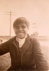 Federation University Historical Collection
Photograph, Aboriginal Student of Antwerp State School Number 1304
Antwerp is near Dimboola, Victoria. The schoo, originally named Antwerp South State School, opened c. 1891.The building was condemned by the Shire of Dimboola in 1909 on health grounds due to overcrowding, and rebuilt. It continued operating until it was closed at the end of 1981 due to falling enrolments, and the buildings were removed from the site. John Gilbert was teaching at Antwerp State School when this photograph was taken. A photographic portrait taken on school photo day. john gilbert, antwerp state school, aborigine, aboriginal -
 Greensborough Historical Society
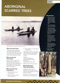
Poster, Victoria. Department of Natural Resources and Environment, Site identification mini poster (#1-2, 4-6, 8-10, 13-14), 2002
This set produced by the Victorian Department of Natural Resources and Environ met and Aboriginal Affairs Victoria. Mini poster 1: Aboriginal scarred trees; 2 Aboriginal mounds; [3 missing]; 4 Aboriginal flaked stone tools; 5 Aboriginal burials; 6 Aboriginal surface scatters; [7 missing]; 8 Aboriginal ground-edge axes; 9 Aboriginal grinding stones; 10 Aboriginal stone arrangements; [11 missing]; 12 Aboriginal axe-grinding grooves; 13 Aboriginal coastal shell middens; 14 Aboriginal rock art.11 parts of incomplete set, each two sided, text and photographsaborigines - victoria, aboriginal affairs victoria -
 Phillip Island and District Historical Society Inc.
Photograph, c. 1800
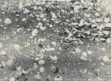
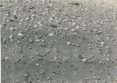
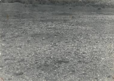
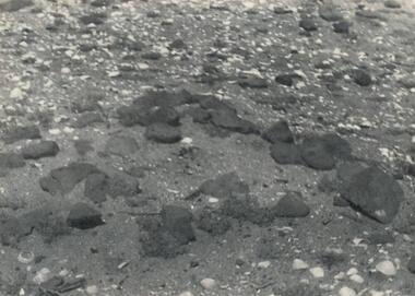
... aboriginal feast site... Island local history photography aboriginal feast site black ...One of a collection of over 400 photographs in an album commenced in 1960 and presented to the Phillip Island & Westernport Historical Society by the Shire of Phillip IslandPhotograph taken at Cat Bay by H. R. Balfour showing shells left from innumerable Aboriginal feasts c. 1800local history, photography, aboriginal feast site, black & white photograph, aborigines, shell fish feasts, cat bay, john jenner, bryant west, h r balfour -
 Phillip Island and District Historical Society Inc.
Photograph, c. 1800
... aboriginal feast site... Island local history photography aboriginal feast site black ...One of a collection of over 400 photographs in an album commenced in 1960 and presented to the Phillip Island & Westernport Historical Society by the Shire of Phillip IslandPhotograph taken at Cat Bay by H. R. Balfour showing shells left from innumerable Aboriginal feasts. c.1800local history, photography, aboriginal feast site, black & white photograph, aborigines, shell fish feasts, cat bay, h r balfour, john jenner, bryant west -
 Phillip Island and District Historical Society Inc.
Photograph, c. 1800
... aboriginal feast site... Island local history photography aboriginal feast site black ...One of a collection of over 400 photographs in an album commenced in 1960 and presented to the Phillip Island & Westernport Historical Society by the Shire of Phillip IslandPhotograph taken at Cat Bay by H. R. Balfour showing shells left from innumerable Aboriginal feasts. c. 1800local history, photography, aboriginal feast site, black & white photograph, aborigines, shell fish feasts, cat bay, h r balfour, john jenner, bryant west -
 Phillip Island and District Historical Society Inc.
Photograph, H. R. Balfour
... aboriginal feast site... Island local history photography aboriginal feast site black ...One of a collection of over 400 photographs in an album commenced in 1960 and presented to the Phillip Island & Westernport Historical Society by the Shire of Phillip IslandPhotograph of the remnants of Aboriginal feasting at Cat Baylocal history, photography, aboriginal feast site, black & white photograph, aborigines, cooking & feasting, h r balfour, john jenner, bryant west -
Glenelg Shire Council Cultural Collection
Book, People of the Lake - the story of Lake Condah Mission, n.d
27,000 years ago molten lava pouring from the eruption of Budjbim (Mt. Eccles) formed Lake Condah and the unique landscape that surrounds it. Over time this area known as "The Stony Rises" or "The Stones" became an important geological area for Koories and, later, Europeans.12 page A4 size booklet, cream with brown print.27,000 years ago molten lava pouring from the eruption of Budjbim (Mt. Eccles) formed Lake Condah and the unique landscape that surrounds it. Over time this area known as "The Stony Rises" or "The Stones" became an important geological area for Koories and, later, Europeans.aboriginal history, gunditjmara, lake condah, mission history, budj bim -
 Greensborough Historical Society
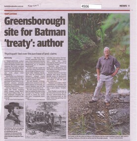
Newspaper - Newspaper Clipping, Heidelberg Leader et al, Greensborough site for Batman "treaty": author, by Rick Koenig, 2017_02
Jim Poulter's research indicates that the accepted account of Batman's Treaty with aboriginal elders regarding purchase of the land of Melbourne is not true. He claims the Treaty was signed in Greensborough.Newspaper clipping, text and images. Date written in black ink: "Feb 2017"john batman, batmans treaty -
 Eltham District Historical Society Inc
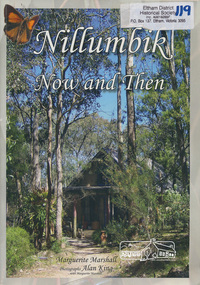
Book, Marguerite Marshall, Nillumbik now and then / Marguerite Marshall; photographs Alan King with Marguerite Marshall, 2008
Nillumbik Now and Then takes the reader on a journey from when the Aboriginal people were this area's sole inhabitnats, to the present day. Nillumbik's history - told in this collection of 96 stories, which are nearly all based on sites - mirrors those of the wider Australian community. It includes tales of the Wurundjeri people, a former convict, farmers, a bushranger, gold-mining, soldiers, artists, intellectuals, environmentalists and sportspeople. Each story is illustrated with a photograph. As a journalist with the former Diamond Valley News, Marguerite Marshall wrote a series of articles on local places of historic interest, later published as the small book "Eltham Shire - Historic Buildings and Places". Many years later an expanded version was published under the title "Nillumbik Now and Then". This is a much larger version of "Nillumbik Now and Then", including significant rewriting and many additional articles. The new publication was made possible by financial support from the Victorian Public Records Office, Bendigo Bank and Nillumbik Shire Council. EDHS and other historical societies in Nillumbik assisted with content for many of the stories. The book was launched at the Eltham Library on Wednesday 19th November 2008. Source: EDHS Newsletter No 183, November 2009 The front cover art depicts The former house of naturalist and artist Neil Douglas at Bend of Islands, photographer Marguerite Marshall. This collection of almost 130 photos and stories about places and people within the Shire of Nillumbik, an urban and rural municipality in Melbourne's north, contributes to an understanding of the history of the Shire. Published in 2008 immediately prior to the Black Saturday bushfires of February 7 2009, it documents sites that were impacted, and in some cases destroyed by the fires. It includes photographs taken especially for the publication, creating a unique time capsule representing the Shire in the early 21st century. It remains the most recent comprehenesive publication devoted to the Shire's history connecting local residents to the past. Paperback; x, 198 p. : ill., ports. ; 30 cm.Signed by the authornillumbik shire, houses, buildings, weller's hotel, landmarks, bend of islands -
 Burrinja Cultural Centre
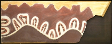
Aboriginal painting - Paddy Jampin Jaminji, Paddy Jaminji, The Hills of Bedford Station, pre 1995
In around 1924 a band of Gija people crossed fences onto their traditional land near Bedford Downs Station in the East Kimberley 2000 km northeast of Perth and killed nine head of cattle. This act precipitated one of the massacres to become known as the 'killing times'. Paddy Quilty, the station owner of Bedford Downs had his men collect wagon loads of firewood which was distributed around the camp. He then invited everyone to assemble for their rations. The food, laced with strychnine, was handed out. As the Gija people fell down dying in agony, they were shot. The firewood was used to burn the bodies. One boy escaped to the the story. Paddy Jamin Jaminji (c.1922-1997) painted The Hills of Bedford Downs Station as part of a series of painting about the Killing Times. It depicts the story and sites of the massacre. At least twelve killing sites are recorded within a radius of 150 km of Turkey Creek, WA. The painting was possibly discarded due to its damage in one corner and later collected from an old shelter at Warmun on a field trip by collector Neil McLeod in 1995.Large painting on board of symbolic landscape. Brown, yellow, cream and white. Framed.bedford downs station, massacre, killing, gija, paddy quilty, turkey creek, warmun -
 Ringwood and District Historical Society
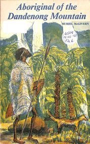
Book, Aboriginal of the Dandenong Mountain - Muriel McGivern
Story of the Aborigines whose hunting and cult sites lay about the foothills of the Dandenongs and the Upper Yarra River