Showing 1533 items
matching aerial photograph
-
 Ringwood and District Historical Society
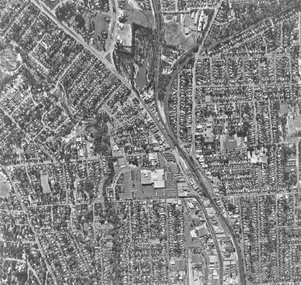
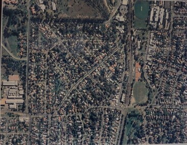
Photograph, Aerial photograph of Ringwood - 1972
... Aerial photograph of Ringwood - 1972...Black and white aerial photograph of Ringwood...., "Ringwood 1972". Black and white aerial photograph of Ringwood ...Black and white aerial photograph of Ringwood.Written on backing sheet, "Ringwood 1972". -
 Federation University Historical Collection
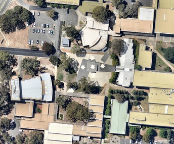
Photograph - Photograph - Colour, Aerial Photograph of the Federation University Mt Helen Campus, c2004
... Aerial Photograph of the Federation University Mt Helen...aerial photograph... helen campus aerial photograph Colour photograph of the Mt Helen ...Colour photograph of the Mt Helen Campus. The stars are at the end of Chancellor Drive.mt helen campus, aerial photograph -
 Victorian Interpretive Projects Inc.
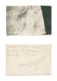
Photograph - digital, Bah Wilson, Aerial photograph of Palestine taken during World War One, 1918, 1918
... Aerial photograph of Palestine taken during World War One...aerial photograph..., 3350 goldfields palestine aerial photograph aeroplane world war ...verso: Taken by Bah Wilson out of an aeroplane. Junction Station. Palestine 1918palestine, aerial photograph, aeroplane, world war, world war one, junction station, mmm -
 Ballarat Heritage Services
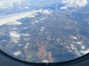
Photograph - Colour, London Aerial Photograph, 2016
... London Aerial Photograph, 2016...aerial photograph... Office goldfields aerial photograph london Photograph of London ...Photograph of London from the air.aerial photograph, london -
 Murrumbeena Cricket Club
Photograph, Aerial photograph of Murrumbeena Park, c. 1945
... Aerial photograph of Murrumbeena Park...Aerial photograph of Murrumbeena Park c. 1945... and reserves Aerial photograph of Murrumbeena Park c. 1945 Aerial ...Aerial photograph of Murrumbeena Park c. 1945murrumbeena, murrumbeena cricket club, cricket, cricket clubs, parks and reserves -
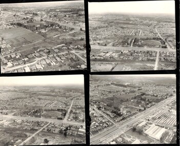 Whitehorse Historical Society Inc.
Photograph, Mitcham aerial photograph in the 1960's
... Mitcham aerial photograph in the 1960's....Four black and white aerial photographs of Mitcham.... Mitcham melbourne Mitcham Township Aerial Photographs Four black ...Four black and white aerial photographs of Mitcham.mitcham township, aerial photographs -
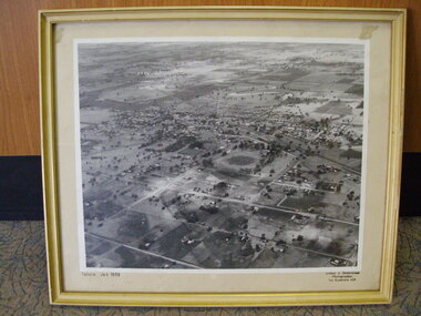 Tatura Irrigation & Wartime Camps Museum
Photograph, Aerial Photograph, Jan-59
... Aerial Photograph...Framed enlarged aerial photograph of Tatura, January 1959.... Tatura Jan 1959 Framed enlarged aerial photograph of Tatura ...Framed enlarged aerial photograph of Tatura, January 1959.Tatura Jan 1959tatura, photography, photograph, slides, film -
 Ballarat and Queen's Anglican Grammar School
b&w Photograph, Aerial photograph of School buildings
... Aerial photograph of School buildings...Aerial photograph of school buildings with large trees... pencilled on verso Aerial photograph of school buildings with large ...Aerial photograph of school buildings with large trees in foregroundVerso - N. L. HARVEY (Press Photo Service) A.M.P. Chambers Lydiard St. N. 2999 pencilled on versoballarat-grammar, wendouree, education -
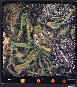
 Heidelberg Golf Club
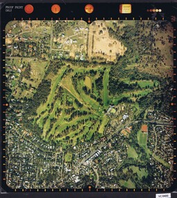
Photograph - Aerial Photograph, Heidelberg Golf Course 2000, 01/05/1980
... Aerial Photograph...Aerial photograph of Heidelberg Golf Club course in 1980...Aerial photograph, colour.... layout and surrounding land use. Aerial photographs Heidelberg ...Aerial photograph of Heidelberg Golf Club course in 1980, showing the course layout and surrounding land use.Aerial photograph, colour.Printed on edge of photo: "Colour proof", "LandSur756"aerial photographs, heidelberg golf club, lower plenty -
 Heidelberg Golf Club
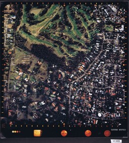
Photograph - Aerial Photograph, Heidelberg Golf Course 2000, 01/05/1980
... Aerial Photograph...Aerial photograph of Heidelberg Golf Club course in 1980...Aerial photograph, colour.... of course and surrounding land use. Aerial photographs Heidelberg ...Aerial photograph of Heidelberg Golf Club course in 1980, showing layout of course and surrounding land use.Aerial photograph, colour.Printed on edge of photo: "Colour proof", "LandSur756"aerial photographs, heidelberg golf club, lower plenty -
 Heidelberg Golf Club
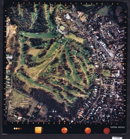
Photograph - Aerial Photograph, Heidelberg Golf Course 2000, 01/05/1980
... Aerial Photograph...Aerial photograph of Heidelberg Golf Club course in 1980...Aerial photograph, colour.... of course and surrounding land use. Aerial photographs Heidelberg ...Aerial photograph of Heidelberg Golf Club course in 1980, showing layout of course and surrounding land use.Aerial photograph, colour.Printed on edge of photo: "Colour proof", "LandSur756"aerial photographs, heidelberg golf club, lower plenty -
 Heidelberg Golf Club
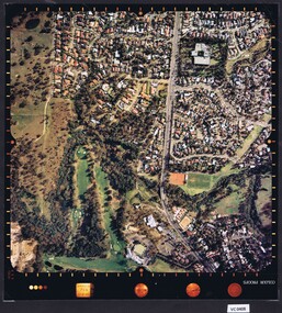
Photograph - Aerial Photograph, Heidelberg Golf Course 2000, 01/05/1980
... Aerial Photograph...Aerial photograph of Heidelberg Golf Club course in 1980...Aerial photograph, colour.... of course and surrounding land use. Aerial photographs Heidelberg ...Aerial photograph of Heidelberg Golf Club course in 1980, showing layout of course and surrounding land use.Aerial photograph, colour.Printed on edge of photo: "Colour proof", "LandSur756"aerial photographs, heidelberg golf club, lower plenty -
 Heidelberg Golf Club
Photograph - Aerial Photograph, Heidelberg Golf Course 2000, 01/05/1980
... Aerial Photograph...Aerial photograph of Heidelberg Golf Club course in 1980...Aerial photograph, colour.... of course and surrounding land use. Aerial photographs Heidelberg ...Aerial photograph of Heidelberg Golf Club course in 1980, showing layout of course and surrounding land use.Aerial photograph, colour.Printed on edge of photo: "Colour proof", "LandSur756"aerial photographs, heidelberg golf club, lower plenty -
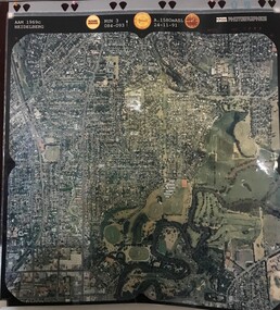
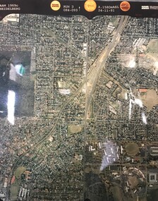 Greensborough Historical Society
Aerial Photograph, AAM Photographics, Heidelberg AAM1969c 084, 24/11/1991
... Aerial Photograph...One of an overlapping series of aerial photographs...Laminated colour aerial photograph... of aerial photographs of the Heidelberg/Greensborough areas ...One of an overlapping series of aerial photographs of the Heidelberg/Greensborough areas, covering Greensborough, Macleod, Viewbank & Yallambie. North boundary Nell Street, South boundary Simpson BarracksLaminated colour aerial photographgreensborough, viewbank, yallambie -
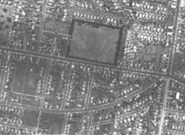
 Ringwood and District Historical Society
Photograph, Aerial photograph of Ringwood - 1962
... Aerial photograph of Ringwood - 1962...Typed below photograph, "Aerial photograph of Ringwood... Road Ringwood North melbourne Typed below photograph, "Aerial ...Typed below photograph, "Aerial photograph of Ringwood. 1962. Old Ringwood Reserve now site Eastland can be seen top left-hand corner". -
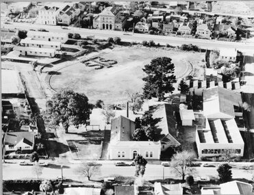 Stawell Historical Society Inc
Photograph, Stawell Technical School Aerial Photograph
... Stawell Technical School Aerial Photograph...Stawell Technical School Aerial Photograph...Stawell Technical School Aerial Photograph stawell ...Stawell Technical School Aerial Photographstawell education -
 Greensborough Historical Society
Aerial Photograph, AAM Photographics, Heidelberg AAM1969c 086, 24/11/1991
... Aerial Photograph...One of a series of four overlapping aerial photographs...Laminated colour aerial photographs... aerial photographs of the Heidelberg/Greensborough areas in 1991 ...One of a series of four overlapping aerial photographs of the Heidelberg/Greensborough areas in 1991, covering Simpson Barracks, Macleod, Rosanna, Viewbank, Watsonia & Yallambie. North boundary Yallambie Road; West boundary Hurstbridge railway.Laminated colour aerial photographssimpson barracks, yallambie, watsonia, macleod, rosanna, viewbank -
 Greensborough Historical Society
Aerial Photograph, AAM Photographics, Heidelberg AAM1969c 088, 24/11/1991
... Aerial Photograph...One of a series of overlapping aerial photographs...Laminated colour aerial photograph... aerial photographs of the Heidelberg/Greensborough area, covering ...One of a series of overlapping aerial photographs of the Heidelberg/Greensborough area, covering Eaglemont, Heidelberg, Ivanhoe East & Viewbank. North boundary Hurstbridge railway, South boundary Ivanhoe East, East boundary Bulleen RoadLaminated colour aerial photographeaglemont, heidelberg, ivanhoe east, viewbank -
 Greensborough Historical Society
Aerial Photograph, AAM Photographics, Heidelberg AAM1969c 106, 24/11/1991
... Aerial Photograph...One of an overlapping series of aerial photographs...Laminated colour aerial photograph... of aerial photographs of the Heidelberg/Greensborough areas in 1991 ...One of an overlapping series of aerial photographs of the Heidelberg/Greensborough areas in 1991, covering the Simpson Barracks, Greensborough & Viewbank. North boundary Nell Street, East boundary Plenty River, South boundary Lower Plenty Road.Laminated colour aerial photographsimpson barracks, greensborough, viewbank -
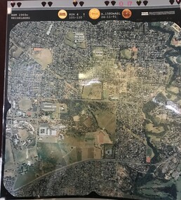
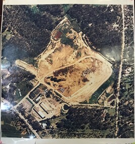
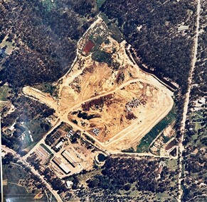 Greensborough Historical Society
Map - Aerial Photograph, Yarrambat, 04/11/1986
... Aerial Photograph...Colour aerial photograph of Diamond Valley Shire Depot...Colour aerial photograph. Scale approx. 1:1000...Colour aerial photograph of Diamond Valley Shire Depot ...Colour aerial photograph of Diamond Valley Shire Depot, Yarrambat, now Nillumbik Shire Council Works Depot & Recycling CentreColour aerial photograph. Scale approx. 1:1000shire of diamond valley, yarrambat, nillumbik council -
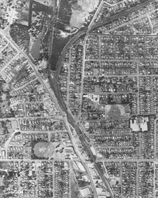
 Greensborough Historical Society
Aerial Photograph, Greensborough, 1945_
... Aerial Photograph...Aerial photograph of Greensborough showing residents...Photocopy of enlargement of 1945 aerial photograph, with 2... Plenty Lower Plenty melbourne Aerial photograph of Greensborough ...Aerial photograph of Greensborough showing residents and businesses in the area. Annotations by Bill Cecil.Photocopy of enlargement of 1945 aerial photograph, with 2 p. of annotations indicating locations of residents and businessesgreensborough, bill cecil -
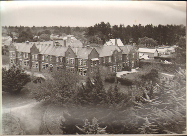
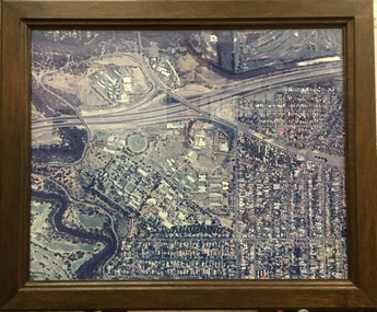 Kew Historical Society Inc
Photograph - Framed Photograph, Aerial Photograph, Willsmere Hospital (Kew), 1988, 1988
... Aerial Photograph, Willsmere Hospital (Kew), 1988...Framed, colour aerial photograph of the Willsmere Hospital.... aerial photographs - kew (vic) dr fred stamp willsmere Framed ...Dr Frederick Stamp graduated from Bristol Medical School (UK) in 1968. He and his family emigrated to Australia in 1977 to Goulburn (NSW), moving to Melbourne in 1980. He became Superintendent at Willsmere in 1991 until its closure in 1988.Important photograph of the Kew Mental Hospital in the year of its closure.Framed, colour aerial photograph of the Willsmere Hospital, presented to Dr Fred Stamp (1941-2018), the Medical Superintendent of the Hospital from 1981 until its closure in 1988.aerial photographs - kew (vic), dr fred stamp, willsmere -
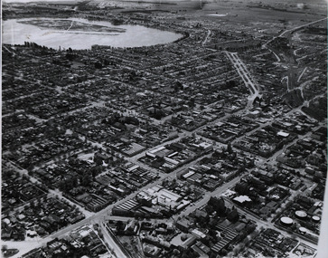 Federation University Historical Collection
Photograph - Photograph - Black and White, Aerial photograph of Ballarat, including the Ballarat School of Mines Campus, c1960
... Aerial photograph of Ballarat, including the Ballarat...Four black and white aerial photograph of Ballarat.... John Valves (Lydiard Street) Aerial photograph of Ballarat ...Four black and white aerial photograph of Ballarat, including the Ballarat School of Mines Campus, former Ballarat Gaol, Lake Wendouree, Ballarat Gasometers, M.B. John Valves (Lydiard Street)ballarat, aerial, ballarat school of mines, ballarat gaol, balllarat brewery, lake wendouree, wendouree -
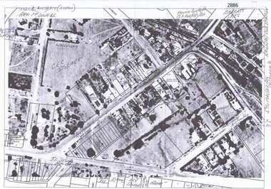
 Eltham District Historical Society Inc
Document - Series Listing, Fraser Faithfull et al, Series 33: Shire Aerial Photograph Collection, 2000
... Series 33: Shire Aerial Photograph Collection...Series consists of 39 aerial photographs and photo maps... melbourne Series consists of 39 aerial photographs and photo maps ...Series consists of 39 aerial photographs and photo maps of the Shire and environs. A separate Item List exists (created on MS Excel spreadsheet), please refer to the attached pagesshire of eltham archives, series listing -
 Federation University Historical Collection
Photograph - Black and White, Aerial Photograph of the Ballarat School of Mines
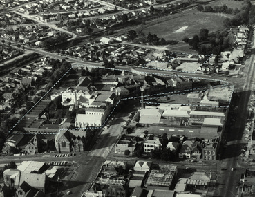
... Aerial Photograph of the Ballarat School of Mines...Aerial Photograph of the Ballarat School of Mines bounded... Aerial Photograph of the Ballarat School of Mines bounded ...Aerial Photograph of the Ballarat School of Mines bounded by Armstrong Street South, Grant Street, Albert Street and Dana Street. Buildings depicted include the Ballarat Brewery, Ballarat Gaol, White Flat Ovalballarat school of mines, ballarat brewery, ballarat club, ballarat uniting church, ballarat school of mines model mine, ballarat school of mines mining workshop, ballarat girls' techncial school, albert street, white flat oval, grant street, lydiard sreet, mining laboratory, model mine, armstrong street south, james oddie's bank -
 Federation University Historical Collection
Photograph - Photograph - Colour, Aerial Photograph of the Ballarat School of Mines Campus, c1995
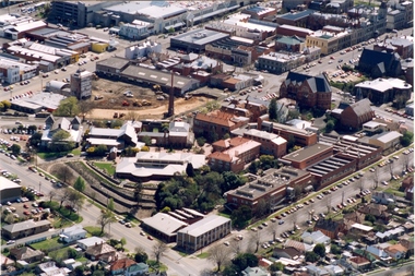
... Aerial Photograph of the Ballarat School of Mines Campus...Colour aerial photograph of the Ballarat School of Mines... ballarat school of mines creche Colour aerial photograph ...Colour aerial photograph of the Ballarat School of Mines campus. Albert street is shown on the lower right side and Grant Stret on the left. The M.B. John Building is present along Albert Street, the Ballarat Brewery has been demolished in preparation for the building of the Brewery Building. ballarat school of mines, aerial, m.b. john building, e.j. tippett library, corbould hall, brewery building, brew tower, brewery chimney, ballarat school of mines creche -
 Federation University Historical Collection
Photograph, Aerial photograph of the Ballarat School of Mines, 1983
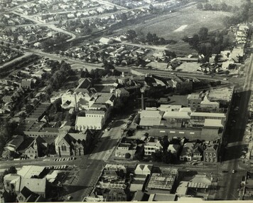
... Aerial photograph of the Ballarat School of Mines...Black and white aerial photograph of central Lydiard Street... the Ballarat School of Mines campus Black and white aerial photograph ...The photo was taken before the Ballarat School of Mines built the M.B. John Building and the Hillman Recreation Centre. Since this photo has been taken most of the Ballarat Gaol and the Ballarat Brewery have been demolished.Black and white aerial photograph of central Lydiard Street south in Ballarat, including the Ballarat School of Mines. The photo shows the former Ballarat Gaol, former Ballarat Courthouse, Ballarat Club, Uniting Church, White Flat, Ballarat Brewery; and was taken before the building of Corbould Hall and the M.B. John Building. White broken lines show the Ballarat School of Mines campusballarat gaol, ballarat courthouse, ballarat club, ballarat townscape, uniting church, ballarat brewery, old plumbing building, flecknoe, administration building, flecknoe building, lydiard street south, ballarat, white flat, ballarat school of mines botanical garden -
 Federation University Historical Collection
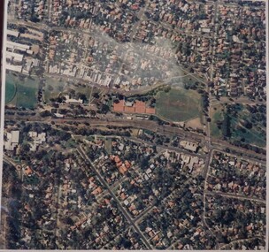
Photograph - Colour - Aerial, Lindsay Stepanow, Federation University Mount Helen Campus, 28/05/1993
... Photograph - Colour - Aerial...Aerial photograph...Aerial photograph of the Mount Helen campus of what... photograph Mount Helen Campus Mount HElen Campus Aerial Ballarat ...Aerial photograph of the Mount Helen campus of what was then Ballarat University College. aerial photograph, mount helen campus, mount helen campus aerial, ballarat university college -
 Greensborough Historical Society
Aerial Photograph, Macleod, 1980c
... Aerial Photograph...Laminated colour aerial photograph... of 5994. macleod Laminated colour aerial photograph Macleod Aerial ...Covers Macleod area. Section of 5994.Laminated colour aerial photographmacleod -
 Greensborough Historical Society
Aerial Photograph, Photo-mapping Services Pty Ltd, Macleod, 1980c
... Aerial Photograph...Laminated colour aerial photograph... aerial photograph Macleod Aerial Photograph Photo-mapping ...Covers Macleod, Bundoora and Greensborough areasLaminated colour aerial photographmacleod, bundoora, greensborough