Showing 61 items
matching aircraft identification
-
 Moorabbin Air Museum
Booklet (Item) - US Aircraft Identification Booklet, Aircraft Recognition for the Ground Observer
... US Aircraft Identification Booklet... Recognition for the Ground Observer Booklet US Aircraft Identification ...Designed to assist the US and Canadian Ground Observer Corps as well as enthusiasts. -
Moorabbin Air Museum
Mixed media (Item) - Dutch Military Aircraft Identification Training Program on Disc, Vliegtuigherkenning
... Dutch Military Aircraft Identification Training Program on.... Vliegtuigherkenning Mixed media Dutch Military Aircraft Identification ... -
 Whitehorse Historical Society Inc.
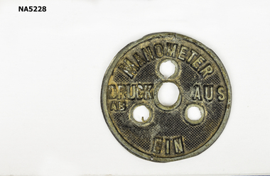
Memorabilia - Aircraft identification badge, Identification Badge, 1914 - 1918
... Aircraft identification badge... Memorabilia Aircraft identification badge ...Part of World War I plane - red Baron aircraft.Round metal badge.EIN AUS DRUCK AB MANOMETER -
Moorabbin Air Museum
Booklet - AIRCRAFT IDENTIFICATION, E. COLSTON SHEPHERD, 1939
... AIRCRAFT IDENTIFICATION...Booklet AIRCRAFT IDENTIFICATION E. COLSTON SHEPHERD Temple ... -
Moorabbin Air Museum
Drawing (item) - Acrylic paintings of Convair 340 Ansett Silhouette comparisons of 767 and Fokker universal Fokker universal Lockheed Electra Boeing 767 727 DC3 Posters of De Havilland drover 727 1987 Moorabbin air show S E 5A instrument panel Ansett 50th anniversary album 31 Beaufighter squadron signed poster FA 18 hornet Sopwith camel Gloster meteor RAAF roundels and insignia F111 Orion P3C Iroquois helicopter FA18 Caribou Ansett 1936 to 1957 Hawker Typhoon Hawker Sea fury Signed poster of various RAAF typhoon squadrons Nieuport biplane RAAF Flying units and Squadrons Australian defence force medals History of RAAF 1921 to 1971 Marshalling signals Battle of Britain survivors article and Poster Lufthansa 747 CRJ200 Kendell airlines Mustang plane and car together m 1988 round Australia race Ansett West Australian airline Damaged Hurricane in workshop Japanese aircraft identification The Last of the Few Qantas recalls 1920 - 1970 MAF serving churches in remote areas Royal flying doctor 1920 - 1978 Douglas C 47 England to Australia 1934 - 1935 Around Australia 1988 CF-650 jet engine airflow Canadair DC-4M north star UIVER KLM memorial flight 1984 also 1934 flight poster Australian Gazette 1710 to 1970 Beaufighters attacking tanker Europe Qantas Air Niugini 4 posters TAA flight deck club Ansett posters Military Helicopters HMAS Albatross 1948 - 1988 RAAF gasoline posters CAC factory photos of Sabre jet manufacture DE Havilland Comet 1934 RAAF military aircraft Wait for help when loading practice bombs RAAF flags Wamira Douglas DC 3 50th anniversary Australian forces badges of rank Emergency access pints for Dakota Wirraway Bristol freighter Wackett Warrigul Boeing Vertol Boomerang Desoutter Koolhoven Gestapo hunters Mosquitos Aarhus, Miscellaneous Aircraft Drawings
... Japanese aircraft identification The Last of the Few Qantas... aircraft identification The Last of the Few Qantas recalls 1920 ... -
Moorabbin Air Museum
Document (Item) - Copies of photos of aircraft parts components identification, Packet 40 Wackett trainer photocopies of photos
... Copies of photos of aircraft parts components... Document Copies of photos of aircraft parts components ... -
Moorabbin Air Museum
Booklet (Item) - Includes pictures of locations aircraft recognition silhouettes identification articles of captured Japanese zero in Papua New Guinea, VAOC (Volunteer Air Observers Corp) Bulletin
... Includes pictures of locations aircraft recognition... aircraft recognition silhouettes identification articles ... -
Moorabbin Air Museum
Document (item) - Recognition Handbook of British Aircraft Air Publication 1480A Part 1 Section A to D
... World War 2 British Aircraft Identification Handbook... Moorabbin melbourne World War 2 British Aircraft Identification ...World War 2 British Aircraft Identification HandbookRECOGNITION HANDBOOK OF BRITISH AIRCRAFT AIR PUBLICATION 1480A Sections A to D Master copy written in pencilworld war 2 aeroplanes, second world war british aeroplane recognition handbook -
 NMIT (Northern Melbourne Institute of TAFE)
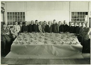
Photograph: CTS 1941 Model Aircraft made by teachers for training armed forces
... personnel in aircraft identification. (Scott p.46)... in aircraft identification. (Scott p.46) Photograph: CTS 1941 Model ...Black and white photograph of a table of model aircraft and Collingwood Technical School teachers who donated one week in December 1941 to make aircraft models to be used to train ared services personnel in aircraft identification. (Scott p.46)collingwood technical school, armed forces training, nmit -
 Bendigo Military Museum
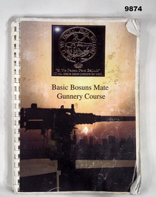
Manual - BASIC GUNNERY COURSE, Royal Navy
... , maintenance schedules, definitions, aircraft identification, ship..., aircraft identification, ship identification including Australian ...The book is for training purposes for Bosuns Mates who are experienced Navy Seaman. Set up for structured training.A.4 size book, 242 pages with emblem of Royal Navy on cover with a picture of a deck gun on the cover. Contains Training program, maintenance schedules, definitions, aircraft identification, ship identification including Australian Navy etc. Book is bound with plastic, 20 ring binding.Title on cover; "Basic Bosuns Mate Gunnery Course".royal navy, gunnery, book, training manual -
 Bendigo Military Museum
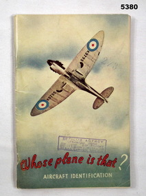
Booklet - BOOKLET, AVIATION, Whitcombe & Tombs Pty Ltd, Whose Aeroplane is That?, 1943
... "Aircraft Identification" is in white ink. Inside are 53 pages... Identification" is in white ink. Inside are 53 pages of Aircraft photos ...Refers to the service of LAC Lance & Percy Coates.This is a booklet with a light cardboard cover, fastened with 2 staples. On the front is an underside view of a spitfire in flight. (Probably an MK1). It has RAF roundels. The phrase "Whose plane is that?" is printed in red ink. The phrase "Aircraft Identification" is in white ink. Inside are 53 pages of Aircraft photos, data and charts of the various warring nations. The front cover has a rubber stamp of McGills Agency, Melbourne.ww2, aircraft -
Moorabbin Air Museum
Mixed media (item) - Brian Ridgeway Collection Miscellaneous aircraft photos, newspaper items etc. See under "Description" Section
... Aircraft Identification. British Monoplanes. Part One. Booklet... Aircraft Identification. Japanese Aeroplanes. Part Five. Booklet ... -
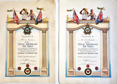 Wodonga & District Historical Society Inc
Certificate - World War II Volunteer Air Observers Corps Certificate of Appreciation, Royal Australian Air Force, 1945
... were continually trained in aircraft identification... were continually trained in aircraft identification ...The Volunteer Air Observers Corps (VAOC) was a civil defence formed on 31st December 1941 as part of the Royal Australian Air Force (RAAF) support during World War II. The VAOC rapidly developed observation posts manned by men and women all over Australia, the main purpose being to identify and report any aircraft movement to an RAAF regional base. During the early days of 1942 the posts were manned 24 hours a day, gradually relaxing as the threat to Australia lessened. All members were continually trained in aircraft identification and provided an invaluable service to the RAAF. The VAOC was disbanded in April 1946. During its operation over 2,600 observations posts were maintained and approximately 25,000 personnel served. These certificates were presented to Mrs. H (Hazel) Penfold and Mr. A. R. (Alexander Rex) Penfold in recognition of 3 years of service during this period. Hazel was the daughter of Mark Ellwood and Rosina Mary Smale and the older sister of Grace, wife of John Hamilton-Smith. The family of Grace and John Hamilton-Smith have donated many items to the Wodonga & District Historical Society. This item commemorates one of the important roles played by civilians on a local, state and national level during WW2 and is attached to a local Wodonga family.2 coloured certificates on cream paper. The design includes 2 aircraft and a man and woman positioned between with the Union Jack and the Australian flag in the top section above the Royal Australian Air Force insignia and the words "For King and Country" Dark cream columns with a pale blue surround frame the details on the certificate. 3 one Years service stickers are attached at the bottom above the insignia of the Volunteer Air Observers Corps.For King and Empire Presented to Mrs H. Penfold by the ROYAL AUSTRALIAN AIR FORCE As a record and in appreciation of patriotic response to the call of country by serving in the VOLUNTEER AIR OBSERVERS CORPS This 20th day of September 1945 signed G. Jones Air Vice Marshall Chief of Air Staff signed ? Unit Commanding Officer volunteer air observers corps, vaoc, civilians in ww2, hamilton-smith collection -
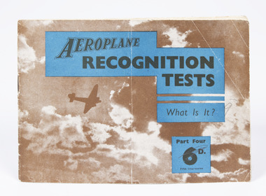 Nhill Aviation Heritage Centre
Booklet - Aircraft recongnition booklets x2, Aeroplane Recognition Test, What is it?, c1930s
... to aid identification of aircraft during WWII. Aircraft... to aid identification of aircraft during WWII. Aircraft ...The book was produced to compliment various publications to aid identification of aircraft during WWII. Aircraft recognition was carried out by RAF crews, Anti Aircraft gun crews, Royal Observer Corps, Civilian Raid Spotters and Shipping. Two books, paperback, 17 pages, black and white images, AEROPLANE Recongnition Tests, What is it? Part 3 images 81 to 116 and Part 4 images 117 to 152 Temple Press Ltd Bowling Green Lane, London -
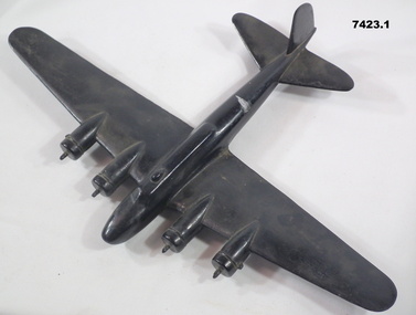 Bendigo Military Museum
Model - AIRCRAFT RECOGNITION (WW2), C. WW2
Aircraft recognition models were produced and painted flat black and lacked any real surface detail or markings in order to simulate a silhouette. Training purposes for both military personnel and civilians alike.1. & 2. Model Aircraft x 2 made from timber and painted black. 1. Has four engines and appears to be a "Boeing B.17 Flying Fortress", an American heavy bomber WW2. 2. Has twin engines - a "Vickers Wellington", a British, long range medium bomber WW2.Handwritten label with models - grey lead pencil. "Recognition Model used to train pilot and gunner in identification. Top. Boe's B17. Bottom Vickers Wellington". 1. Label on bottom of model - "FORTRESS"military, aircraft, training, ww2 -
 Bendigo Military Museum
Photograph - Royal Australian Survey Corps Aerial Surveys, c1980
This is a set of nine photographs of technicians from the Royal Australian Survey Corps operating aerial surveys equipment c1980s. In photo .1P, CPL Steve Gloster was operating a RC10 air survey camera mounted in an Australian Army Pilatus Porter aircraft. The Wild RC10 super wide-angle air survey cameras were first introduced in 1971, were equipped with virtual distortion free lenses for supplementary, spot and special photography. In photo .2P, Roger Rees was operating Air Profile Recorder (APR) equipment. it was possibly taken during OP NERVOSE 84, sometime between June – August 1984 when based in Ngukurr, Northern Territory. The APR was operated at this time in unison with an RC10 camera. In 1963 the Royal Australian Survey Corps introduced the radar airborne profile recorder (Canadian Applied Research Ltd, Mark V, Airborne Profiler Recorder) was introduced for 1:100,000 mapping to replace terrain heighting by aneroid barometry. Later in 1974-1975, the Australian developed WREMAPS II airborne laser terrain profile recorder was introduced. In photo .3P, Neil Jones appears at the door of Airsearch Beechcraft Queen Air aircraft, Registration / Serial VH-MWX. This aircraft was typically used by RA Svy on air survey operations flying mission with Aerodist, APR and RC10 camera equipment. The Australian Army’s Pilatus Porter (short take-off and landing turbo propeller) was also equipped with a Wild RC10 aerial mapping camera for identification photography. The Pilatus Porter was also used on RA Svy’s map field checking operations. Photo .9P was taken at a survey station at an unknown location. In this photo an Australian Army Kiowa Light Observation Helicopter (LOH) is supporting a field survey party undertaking Magnavox AN/PRR-14 portable Doppler satellite observations. The satellite receiver’s antenna is plumbed over the survey ground mark surrounded by white plastic panels. The panels were used to identify the survey station on aerial photography. Introduced in 1974–1975, the Magnavox AN/PRR-14 portable Doppler satellite (US Navy Navigation Satellite System – TRANSIT) receivers and computing system provided independent three-dimensional point positions anywhere in the world, anytime, in any weather accurate to about 1.5metres with precise satellite ephemerides. The Bell OH-58 Kiowa LOH was a family of military helicopters used for observation, utility, and direct fire support. It was identified by RA Svy in the mid-1970s that considerable time was lost in replacing unserviceable remote equipment by road. Therefore Aerodist operations (pre-dating satellite receiver operations) were fully supported by Army’s Kiowa LOH aircraft. This is a set of nine photographs of technicians from the Royal Australian Survey Corps operating aerial surveys equipment c1980s. .1P to .3P, .5P to .9P - Colour and black and white photos on photographic paper and scanned at 300 dpi. .4P - Colour photo on 35mm slide film and scanned at 96 dpi. .1) & .2) - Photo, black & white, c1980s, CPL Steve Gloster operating an RC10 air camera. .3) - Photo, colour, 1984, Roger Rees operating Air Profile Recorder (APR) equipment. .4) - Photo, colour, c1980s, Neil Jones at the door of an Airsearch Beechcraft Queen Air aircraft, typically used by RA Svy on air survey operations. .5) - Photo, colour, c1980s. A Beechcraft King Air aircraft, also used by RA Svy on air survey operations. .6) - Photo, colour, c1980s. An Australian Army Pilatus Porter, used by RA Svy on air survey and map field checking operations. SGT Peter Mustart is possibly in the foreground. .7) to .8) - Photo, colour, c1980s. An Australian Army Pilatus Porter and unidentified personnel, used by RA Svy on air survey and map field checking operations. .9) - Photo, colour, c1980s. An Australian Army Kiowa helicopter supporting a field survey party undertaking Magnavox AN/PRR-14 portable Doppler satellite observations. There are biro marks on photos .4P to .9Proyal australian survey corps, rasvy, army survey regiment, asr, fortuna, aerial surveys -
 Bendigo Military Museum
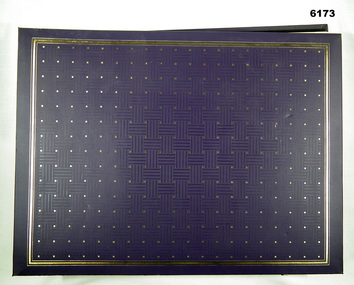
Album - Photographic Identification Guide (PIG) of the Gove Penisula (Sic) Peninsula, Army Topographic Support Establishment, May 1997
These photographs and a video were captured in May 1997 by Jeff Ruiz and Wayne Walsh from the Army Topographic Support Establishment (ATSE). The video taken onboard an aircraft has not been located at this time. A flight line diagram showing the path of the aircraft taking the video is enclosed in the album. The Army Topographic Support Establishment was created to perform some of the functions of the Army Survey Regiment.A Large Purple covered Album with gold dots containing maps, plans and coloured photographs of Gove Peninsula.royal australian survey corps, rasvy, fortuna, army survey regiment, army svy regt, asr, atse -
 National Vietnam Veterans Museum (NVVM)
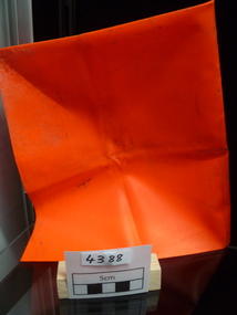
Equipment - Equipment, Army, Marker panel
Red fluoro plastic square used for identification of patrol location for aircraft.marker panel, sas -
 Australian Gliding Museum
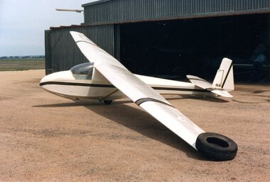
Machine - Glider – Sailplane, 1959
This aircraft was designed by Edmund Schneider as a single seat medium performance sailplane. Originally designated as the Grunau 3b but later named the Grunau 4. However, it was a new design with fully enclosed cockpit. The main point of difference to earlier Schneider Grunau designs was the tapered wings with the Gottingen 549 aerofoil. This design feature gave the Grunau 4 a better speed range compared to the Grunau Baby 2b or the Grunau 3. The prototype flew on 6 December 1953 and it went to the Waikerie Gliding Club. A second was delivered to the Dubbo Gliding Club in October of the next year and a third (the Australian Gliding Museum’s exhibit) built for the Adelaide Soaring Club in 1959 (registered as VH-GLX on 21 October 1959). Another was built by Josef Brabec from a Schneider supplied kit from 1954 to 1956. The log book indicates that the glider recorded 2362 flying hours over approximately 40 years of active service. There are many long flights recorded. The registration was cancelled on 30 July 2014 as a result of a decision by the Museum to withdraw the glider from service. The exhibit represents the final development of the "Grunau" single seat type by Edmund Schneider Ltd in Australia. Viewed together with the Grunau Baby gliders in the ATO Collection (Two Grunau Baby 2, and a Grunau Baby 3A), the changes to this glider type over a 30 year period can be recognized. Single seat wooden sailplane with fabric covering. Fully enclosed cockpit. The aircraft is white with Linden Green on the wing tips, tailplane and underside of the fuselage and also on the central wing cover. Identification Plate in cockpit showing that glider is serial number 37 built by Edmund Schneider Ltd in 1959 australian gliding, glider, sailplane, grunau, grunau 3a, grunau 3b, grunau 4, schneider, waikerie gliding club, dubbo gliding club, adelaide soaring club, josef brabec -
 Monbulk RSL Sub Branch
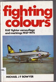
Book, Michael JF Bower, Fighting colours: RAF fighter camouflage and markings 1937-1975, 1975
The standard reference work of RAF camouflage and markings on all sorts of aircraftill (b/w plates), charts, p.187.non-fictionThe standard reference work of RAF camouflage and markings on all sorts of aircraftairplanes - military - markings - great britain, airplanes - identification - great britain -
Moorabbin Air Museum
Manual (item) - CAC General Standards, Identification of Standard Parts & Misc. Items for use on Computerized Parts Lists & Drawings
... Moorabbin melbourne Commonwealth Aircraft Corporation Identification ...Commonwealth Aircraft Corporation -
Moorabbin Air Museum
Manual (item) - CAC Commonwealth Aircraft Corporation Materials Engineering Instructions, Material Engineering Instruction M.E.I.-12B Identification of "O" Ring Type Packings, Gaskets & Seals
Commonwealth Aircraft Corporation -
 Dandenong/Cranbourne RSL Sub Branch
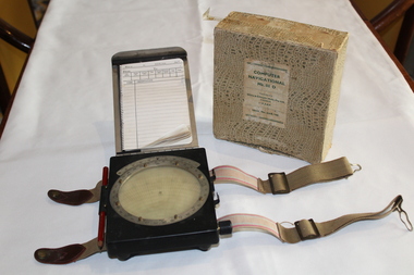
Equipment - RAAF Navigational Computer, White and Gillespie (Melb.) Pty Ltd, Possibly 1940
WWII Historical significanceRAAF Navigational computer MK111 D used in WW11 in aircraft for plotting direction and wind speed with original box.Identification number G6B/145. Serial No WG/2677*. Contains original pencil from 1940 and navigational notebook. -
Moorabbin Air Museum
Drawing (Item) - Identification Markings on Aircraft Drawings
... Identification Markings on Aircraft Drawings...Identification Markings on Aircraft Drawings... Moorabbin melbourne Identification Markings on Aircraft Drawings ... -
Moorabbin Air Museum
Document (Item) - CAC Wirraway Parts Identification Schedule, "Wirraway" "B" Standard Parts Identification Schedule, 1940s
... Wirraway Parts Identification Schedule COMMONWEALTH AIRCRAFT ... -
Moorabbin Air Museum
Photograph (Item) - Image of a crashed B-25 Mitchell
... No roundels or identification markings on the aircraft... Moorabbin melbourne No roundels or identification markings ...No roundels or identification markings on the aircraft are visible. -
 Bendigo Military Museum
Photograph - 4th Field Survey Squadron deployed on Operation NERIGHT, Queensland & Northern Territory, 1989
This is a set of 19 photographs taken in 1989 during 4th Field Survey Squadron’s deployment on Operation NERIGHT 89 in Queensland and the Northern Territory. It was a two-part operation in 1989 with work conducted in the areas of Camooweal and Weipa. Part 1 was the field completion of topographic maps conducted near Camooweal QLD, along the Barkley Highway on the border between NT and QLD, from the 12th of September to the 20th of October 1989. A Bell Kiowa LOH helicopter from 162 Recce Sqn supported topographic field completion. Operation NERIGHT 89 Part 2 was the acquisition of mapping control by GPS field parties utilising Texas Instruments TI4100 Global Positioning System receivers around Weipa on Cape York Peninsula from the 22nd of September to the 22nd of October 1989. Part 2 Two Bell UH-1H Iroquois helicopters from RAAF’s 35 Squadron were principally used to deploy GPS field parties. Identification photography of control points was taken by air camera operators in AAAvn Pilatus Porter aircraft from 173 Gen Spt Sqn fitted with an RC10 aerial camera. The two parts of the operation were conducted concurrently. This is a set of 19 photographs taken in 1989 during 4th Field Survey Squadron’s deployment on Operation Neright in Queensland & the Northern Territory. The colour photographs are on 35mm negative film and are part of the Army Survey Regiment’s Collection. The photographs were scanned at 96 dpi. .1) to .3) - Photo, colour, 1989. En-route to areas of survey operations. .4) to .5) - Photo, colour, 1989. Unidentified personnel relax next to river/waterhole. .6) - Photo, colour, 1989. Two Bell UH-1H Iroquois helicopters from RAAF’s 35 SQN utilised in the movement of GPS parties. .7) to .9) - Photo, colour, 1989. Unidentified soldier practices repelling from a UH1H Iroquois helicopter. .10) - Photo, colour, 1989. Inside the cockpit of a UH1H Iroquois helicopter. .11) - Photo, colour, 1989. Field Party camp with GPS equipment in foreground. Unidentified soldier prepares a meal. .12) - Photo, colour, 1989. GPS antenna plumbed over a survey ground mark. Witness post on left. .13) & .14) - Photo, colour, 1989. Unknown Cape York Peninsula beaches. .15) & .16) - Photo, colour, 1989. Dramatic fire next to base camp. .17) - Photo, colour, 1989. Aboriginal rock art at unknown location. .18) - Photo, colour, 1989. Aboriginal rock art at unknown location. L to R: unidentified, SPR Andrew Quin. .19) - Photo, colour, 1989. Aboriginal rock art at unknown location. LT Chris Topovsek..1P to .19P – There are no personnel identified. ‘1989 OP NERIGHT’ annotated on negative sleeve.royal australian survey corps, rasvy, 4 fd svy sqn, op neright 89 -
 Clunes Museum
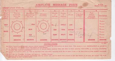
Ephemera - AIR FLASH MESSAGE FORM, 1942
MRS. ANDREW McLENNAN [ALMA] WAS AN OBSERVER FROM 1042 WHILE LIVING AT TOURELLO ESTATE, SMEATON ROAD, CLUNES.AIR FLASH MESSAGE FORM ISSUED TO NOMINATED OBSERVERS OF AIRCRAFT FLYING IN IMMEDIATE AREA. OBSERVER TO RECORD AND REPORT THE POSITION, DIRECTION, NUMBER OF ENGINES, HEIGHT, TIME SEEN OR HEARD AND TYPE OF AIRCRAFT TO AIRFORCE CONTROL BASE [BALLARAT] DURING 1939-1945 WORLD WAR .local history, document, identification, military, airforce, ww2 -
 Bendigo Military Museum
Photograph - RA Svy Project C4 Aerodist Operation, Eastern Arnhem Land, NT, 1967
This is a set of 30 photographs of Royal Australian Survey Corps (RA Svy) personnel from Central Comd Fd Svy Unit (Adelaide) on Aerodist survey operation - Project C4 in Eastern Arnhem Land, Northern Territory in 1967. Photos of personnel were taken either at the operations base at Numbulwar or the main base at Gove (Nhulunbuy). RA Svy conducted nineteen Aerodist operations for 12 years from 1964 to 1975. Aerodist MRC2 was a tellurometer-based system adapted for aircraft to accurately measure distances between non-intervisible ground survey stations, using the aircraft as an intermediate station. Lower order geodetic results could be achieved by survey network trilateration. The measured distances between stations formed survey networks from which each station’s latitude and longitude was computed. Aerodist MRC2 was RA Svy’s major horizontal control survey tool for mainly medium scale topographic mapping (scale 1:100,000 Class A being spatially accurate to within 50 metres) in PNG, northern NT, north-west WA, Kalimantan Barat (West) Indonesia, Sumatra Indonesia, Gulf of Carpentaria and Cape York, QLD. In 1967, the Aerodist MRC2 Master equipment was installed in the aircraft featured in this set of photos, Executive Air Services’ (Essendon VIC) Grand Aero Commander VH-EXX. It was the same aircraft type and company contracted to Division of National Mapping for Aerodist MRC2 surveys. From July to October 1967 the aircraft was attached to Central Comd Fd Svy Unit (Adelaide - Major Don Ridge) on Project C4 eastern-Arnhem Land NT, where 317 Aerodist lines measuring 17,300 line miles were successfully completed. This was the most productive Aerodist project thus far. The most common helicopter used by RA Svy up to 1972 was the civilian Bell 47G-2 and the Sioux Light Observation Helicopters (LOH), the Australian Army’s equivalent featured in this photo set. These light observation helicopters had a limiting load carrying capacity of up to about 500 pounds. By comparison, one Aerodist team including two people weighed up to 1,500 pounds. Source: Royal Australian Survey Corps – Aerodist Years 1964-1975 by Peter Jensen. This is a set of 30 photographs of Royal Australian Survey Corps (RA Svy) personnel on Aerodist survey operations in Eastern Arnhem Land, Northern Territory in 1967. The photographs are on 35mm negative film and scanned at 96 dpi. They are part of the Army Survey Regiment’s Collection. .1) to .4) - black & white, 20th August 1967, Project C4 Aerodist Operations Base - Numbulwar, NT. .5) - Photo, black & white, 1967. Probable wrecked Indonesian fishing vessel. .6) to .8) - Photo, black & white, 1967. Unidentified survey operations base, L to R: unidentified personnel. .9) - Photo, black & white, 1967. Unidentified survey operations base, unidentified soldier driving a Haflinger 4x4 Light utility vehicle. .10) - Photo, black & white, 1967. Unidentified survey operations base, L to R: unidentified technician. .11) - Unidentified technician reading two survey altimeters to compute corrections to the measured distances for atmospheric refraction and to compute the sea level distances from the slope distances aircraft to the ground stations. .12) - Photo, black & white, 1967. Unidentified survey operations base, L to R: unidentified personnel. .13) to .16) - Photo, black & white, 1967. Unidentified personnel operating remote Aerodist MRC2 ground instruments. .17) to .18) - Photo, black & white, 1967. Unknown RA Svy office location. .19) to .20) - Photo, black & white, 1967. Aerodist MRC2 Master equipment. .21) to .22) - Photo, black & white, 1967. Aero Commander VH-EXX probably at Gove, NT, Central Comd Fd Svy Unit (Adelaide) – OC Major Don Ridge. .23) to .25) - Photo, black & white, 1967. Aero Commander VH-EXX probably at Gove, NT. Unidentified personnel. .26) - Photo, black & white, 1967. Aero Commander VH-EXX probably at Gove, NT. Aerodist antenna pods are visible on the aircraft. .27) to .29) - Photo, black & white, 1967. Australian Army Sioux Light Observation Helicopter (LOH) probably at Gove, NT. .30) - Photo, black & white, 1967. Panelled U337 survey station, visible as a white cross on aerial identification photo..1P to .2P – date and location on edge of film negative. .5P to .28P – no annotations .29P - annotated in white ‘RW-JEP Gove NT’ .30P - annotated in white ‘U337 Spool No1 Jun67’royal australian survey corps, rasvy, army survey regiment, army svy regt, fortuna, asr, aerodist, surveying, central comd fd svy unit -
 Bendigo Military Museum
Photograph - 4th Field Survey Squadron – Operation ARIGHT 91, Queensland, 1991
This is a set of 16 photographs taken during 4th Field Survey Squadron’s deployment on Operation ARIGHT 91 in Queensland from the 8th of July to the 5th of September 1991. The area of operations was the top end of the Cape York Peninsula, islands of the Torres Strait and the southern coast of PNG. Field parties utilised Texas Instruments TI4100 Global Positioning System receivers. Concurrent with GPS operations Doppler point positioning observations were carried out by field parties using Magnavox MX 1502 receivers on six of the control points. Two Bell UH-1H Iroquois helicopters from RAAF’s 171 COMD and Liaison Squadron were primarily used to deploy GPS field parties. Identification photography of control points was taken by air camera operators in AAAvn Pilatus Porter aircraft from 173 Gen Spt Sqn fitted with an RC10 aerial camera.This is a set of 16 photographs taken in 1991 during 4th Field Survey Squadron’s deployment on Operation ARIGHT in Queensland. The colour photographs are on 35mm negative film and are part of the Army Survey Regiment’s Collection. The photographs were scanned at 96 dpi. .1) to .3) - Photo, colour, 1991. Area of Operations (AO) coordination maps. .4) - Photo, colour, 1991. GPS acquisition post-processing. L to R: LT Simon Buckpitt, SSGT Steve Winner, WO2 Ken Talbot-Smith. .5) to .6) - Photo, colour, 1991. Base camp unidentified personnel. .7) - Photo, colour, 1991. L to R: OPS WO - WO2 Ken Talbot-Smith, DET SSM WO1 Stevo Hinic. .8) - Photo, colour, 1991. Base camp unidentified personnel. .9) - Photo, colour, 1991. Base camp L to R: unidentified (x2), OPS WO - WO2 Ken Talbot-Smith. .10) - Photo, colour, 1991. Base camp unidentified soldier. .11) - Photo, colour, 1991. Base camp L to R: CPL Andy Love, unidentified, SGT Steve McGuiness. .12) - Photo, colour, 1991. Base camp at Horn Island Army Compound. .13 to .16) - Photo, colour, 1991. Unknown locations in Area of Operations..1P to .16P – There are no personnel identified. ‘1991 OP ARIGHT’ annotated on negative sleeve.royal australian survey corps, rasvy, 4 fd svy sqn, op aright 91