Showing 1392 items
matching allotments
-
 Kew Historical Society Inc
Plan, J R Mathers & McMillan, 5 Splendid vVlla Allotments,: Segtoune St. & Windsor St., Kew, 1928
... 5 Splendid vVlla Allotments,: Segtoune St. & Windsor St ...Prue Sanderson, in her groundbreaking ‘City of Kew Urban Conservation Study : Volume 2 - Development History’ (1988), summarised the periods of urban development and subdivisions of land in Kew. The periods that she identified included 1845-1880, 1880-1893, 1893-1921, 1921-1933, 1933-1943, and Post-War Development. These periods were selected as they represented periods of rapid growth or decline in urban development. An obvious starting point for Sanderson’s groupings involved population growth and the associated economic cycles. These cycles also highlighted urban expansion onto land that was predominantly rural, although in other cases it represented the decline and breakup of large estates. A number of the plans in the Kew Historical Society’s collection can also be found in other collections, such as those of the State Library of Victoria and the Boroondara Library Service. A number are however unique to the collection.Subdivision plans are historically important documents used as evidence of the growth of suburbs in Australia. They frequently provide information about when the land was sold on which a built structure was subsequently constructed as well as evidence relating to surveyors and real estate and financial agents. The numerous subdivision plans in the Kew Historical Society's collection represent working documents, ranging from the initial sketches made in planning a subdivision to printed plans on which auctioneers or agents listed the prices for which individual lots were sold. In a number of cases, the reverse of a subdivision plan in the collection includes a photograph of a house that was also for sale by the agent. These photographs provide significant heritage information relating house design and decoration, fencing and household gardens.In 1928, five residential allotments bordering Segtoune and Windsor Streets were advertised for sale as part of a subdivision. Four of the blocks faced Segtoune Avenue. The auctioneers proclaimed the advantages of the sites: ‘Situate one minute from the High Street Electric Tram, which now runs direct to Spencer Street via Bridge Road and Flinders Street. Opposite the East Kew Railway Station (Outer Circle Line), which may be reopened In connection with the new Line from Kew to Doncaster; Adjacent lo the Kew Recreation Reserve, Sports Oval, and Swimming Bath; Half Minute from the Shopping Centre of East Kew, Accessible to the State School and Other Educational Centres’. The Harp of Erin Hotel and the route of the Outer Circle Railway line are marked on the plan. The Recreation Reserve and Sport Oval refer to Victoria Park. The Swimming Baths were located on the site of the current Kew Recreation Centre.subdivision plans - kew, segtoune street -- kew (vic.), windsor street -- kew (vic.) -
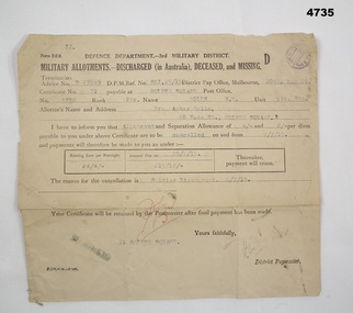 Bendigo Military Museum
Financial record - MILITARY ALLOTMENTS, Department of defence 3rd Military District, 6.7.1918
... Allotments ...Norman McKenzie Rolls. The document relates to the cancellation of allotments from him to his Mother Mrs Agnes Rolls of Golden Square Bendigo.Document off white colour rectangular shape form Z.C.2, all print in black, typed in blue, initialled in red, purple stampin top RH corner, termination advice no “D27869”. Form relates to Military allotments for discharged, deceased or missing Soldier.Main points re Soldier, “No 3938 Pte Rolls, N.M 5th BTN”allotments, documents, payments -
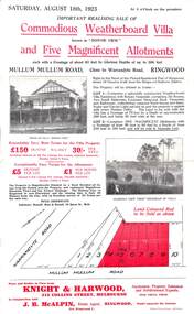 Ringwood and District Historical Society
Flyer, Advertisement for Mullum Mullum Road, Ringwood, Vic., Sale of "Bonnie View" Villa and five allotments. - 1923
... of "Bonnie View" Villa and five allotments. - 1923. ...Single page flyer advertising realising sale of villa and land in Mullum Mullum Road, Ringwood, at 3 o'clock on Saturday, August 18th, 1923. Also includes descriptions and photographs of the property, location of the blocks, and summary of local train services.Auctioneer - Knight & Harwood, 315 Collins Street, Melbourne, Tel 10615, 10616, in conjunction with local agent - J.B. McAlpin, Opposite Railway Station, Ringwood, Tel. Ringwood 7. -
 Ringwood and District Historical Society
Map, Allotments - Township of Ringwood - Parish of Ringwood - County of Mornington - 1886, 1886
... Allotments - Township of Ringwood - Parish of Ringwood ...[Page 3, Horse Shoes to High Heels - Richard Carter] ... "(In the year 1882) the railway was extended from Hawthorn through Ringwood to Lilydale and later to Ferntree Gully." Linen-backed map of Ringwood area lithographed at the Department of Lands and Survey, Melbourne, 5th November, 1886.old lilydale road, new lilydale road, victoria brick and tile co., ringwood brick co., federal brick co. -
 Eltham District Historical Society Inc
Slide - Photograph, Eltham Shire Council, Plan of Subdivision, Part of Crown Allotments 5 & 6, Section 10, Parish of Nillumbik, County of Evelyn (Foster Road, Eltham East), 1969
... Plan of Subdivision, Part of Crown Allotments 5 & 6 ...35mm colour positive transparency blue Agfacolour Service plastic mountC5(a) DU (Vic) D/L Foster Road, Eltham East, 4 August 1969infrastructure, map, planning, subdivison lots, abersham court, ancona close, eltham east, floriston grove, foster road, frank street, gladwyn court -
 Federation University Historical Collection
Plan, Ballarat School of MInes Allotments
... Ballarat School of MInes Allotments ... -
 Ringwood and District Historical Society
Legal record - Conditions of Sale (C.E.Carter), Ringwood East - Crown Allotments 35 & 36 - R. Davidson to Mrs J. A. E. Tudman. 1926
... Ringwood East - Crown Allotments 35 & 36 - R. Davidson to ...Particulars and Conditions of Sale of Property , from Robert Davidson to Jessie Tudman -
Stawell Historical Society Inc
Map, Department of Crown Lands and Survey Victoria, Allotments in the Township of Banyana. Parish of Burrum Burrum. 1946 / 1971, 1971
... Allotments in the Township of Banyana. Parish of Burrum ...Richardson River. Avon River JunctionPaper Map of County of BorungReprint of the 1946 edition. Drawn and reproduced at the Department of Crown Lands and Survey Victoria 1971.survey -
Tatura Irrigation & Wartime Camps Museum
Poster, Subdivision of Township Allotments
... Subdivision of Township Allotments ...Poster depicting the land which was being sold by J S Darby on the 3 December 1890. Auctioneer was Martin Cussen and Co. Map shows location of land.Single sheet of paper, laminated. Advertising land subdivision for sale in the township of Rushworth. Being sold by Martin Cussen and Co, auctioneers for J S Darby. Shows map of land subdivision.rushworth, land subdivision, martin cussen and co, j s darby -
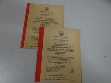 Brimbank City Council
Land Sale Booklet x 2 (2 copies of the same booklet), Sale of allotments of land at Keilor East, West Essendon and St Albans 1954
... Sale of allotments of land at Keilor East, West Essendon ...land sale -
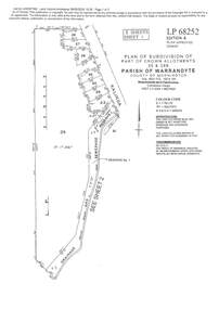
 Kew Historical Society Inc
Plan - Subdivision Plan, 6 Choice Residential Allotments: East Kew, 1932
... 6 Choice Residential Allotments: East Kew ...Prue Sanderson, in her groundbreaking ‘City of Kew Urban Conservation Study : Volume 2 - Development History’ (1988), summarised the periods of urban development and subdivisions of land in Kew. The periods that she identified included 1845-1880, 1880-1893, 1893-1921, 1921-1933, 1933-1943, and Post-War Development. These periods were selected as they represented periods of rapid growth or decline in urban development. An obvious starting point for Sanderson’s groupings involved population growth and the associated economic cycles. These cycles also highlighted urban expansion onto land that was predominantly rural, although in other cases it represented the decline and breakup of large estates. A number of the plans in the Kew Historical Society’s collection can also be found in other collections, such as those of the State Library of Victoria and the Boroondara Library Service. A number are however unique to the collection.Subdivision plans are historically important documents used as evidence of the growth of suburbs in Australia. They frequently provide information about when the land was sold on which a built structure was subsequently constructed as well as evidence relating to surveyors and real estate and financial agents. The numerous subdivision plans in the Kew Historical Society's collection represent working documents, ranging from the initial sketches made in planning a subdivision to printed plans on which auctioneers or agents listed the prices for which individual lots were sold. In a number of cases, the reverse of a subdivision plan in the collection includes a photograph of a house that was also for sale by the agent. These photographs provide significant heritage information relating house design and decoration, fencing and household gardens.The mansion Woodlands in Harp Road, East Kew suffered the death of a thousand cuts. In its case, the cuts were subdivisions. Previous subdivisions of the mansion and its grounds were given titles such as ‘The Eastlawn Estate’ (MAP.0055), whereas at the end, the subdivision called it as it was, naming itself the ‘final section of the Woodlands Estate’ when it was put up for auction in 1932. The emphasis in the promotion of the subdivision was that it provided purchasers with splendid opportunities ‘to build modern homes in select, well established modern surroundings’. As with other subdivisions in the interwar period, transport links were emphasised. The six residential lots cut Woodlands off from Harp Road. When the vendor, Louisa Rachel Preston Hill, was to die at Woodlands in 1937 aged 86 her address was given as Normanby Road.subdivision plans - kew, woodlands estate -
University of Melbourne, Burnley Campus Archives
Map, Plan of Early Melbourne Showing Original Crown Allotments, c. 1852
... Plan of Early Melbourne Showing Original Crown Allotments ...Copy of 'Map of the City of Melbourne, and its Extension, together with Collingwood, Richmond, Hawthorne, the Emerald Hill, and a portion of Prahran Compiled from the Government Plans and Private Survey by William Green.' (2 copies, one enlarged)melbourne, william green, richmond, hawthorne, collingwood -
Merbein District Historical Society
Map, White Cliffs Irrigation Settlement - Plan of Homestead Allotments, 1917
... Allotments ...blocks, irrigation, parish of merbein, homestead allotments -
Merbein District Historical Society
Map, White Cliffs Irrigation Settlement - Plan of Homestead Allotments, 1917
... Allotments ...homestead allotments, parish of merbein, county of karkarooc, blocks, irrigation settlement -
Merbein District Historical Society
Map, Birdwoodton (Merbein) Allotments - Sec A, 4 Mar.1938
... Birdwoodton (Merbein) Allotments - Sec A ... -
Merbein District Historical Society
Map, Township of Merbein - Sale of Allotments, 29 Jul.1914
... Township of Merbein - Sale of Allotments ... -
Merbein District Historical Society
Map, Parish of Merbein - Irrigation Allotments, 3 Aug.1912
... Parish of Merbein - Irrigation Allotments ...irrigation -
 Ringwood and District Historical Society
Document - Subdivision Plan, LP113220 Part of Crown Allotments 35 & 39B, Parish of Warrandyte, County of Mornington, Vol 6421 Fol 183 & 184 - 1965
... LP113220 Part of Crown Allotments 35 & 39B, Parish of ...LANDATA Land Victoria 2-sheet plan printout dated 2009Sheet 1 includes Kalinda Road, Ringwood. Additional markings include LP113117. Sheet 2 includes Kalinda Road and Maroondah Highway, Ringwood. Additional markings include LP86253. Both sheets include location of Drainage and Sewerage Reserve along Mullum Mullum Creek. -
 Ringwood and District Historical Society
Document - Map, Plan of Subdivision - Part of Crown Allotments 14A & 14C, Parish of Ringwood, County of Mornington, Vol 5378 Fol 511 - 1927
... Plan of Subdivision - Part of Crown Allotments 14A & 14C ...Department of Lands and Survey photocopy dated 17/1/1951, page number 12308.Map includes Canterbury Road, Heathmont Road, Dickasons Road, Bennett Avenue, Orchid Street and Allens Road, Heathmont, Vic. -
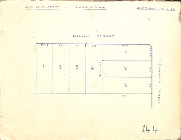 Ringwood and District Historical Society
Map, Hand-drawn outline of residential allotments in Nelson Street and Ringwood Street, Ringwood, Vic., headed Mrs N.M. Adam - Subdivision - Auction 26.6.54
... Hand-drawn outline of residential allotments in Nelson ...Pen drawing on cardboard backing. -
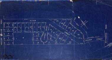 Ringwood and District Historical Society
Map, Subdivision Plan of residential allotments in Mullum Mullum Road, Oliver Street and Lister Court, Ringwood, Victoria - (Undated)
... Subdivision Plan of residential allotments in Mullum Mullum ...Blueprint copy on cardboard backingNorth directional indicator includes name of Surveyor and Town Planner, Saxil Tuxen. -
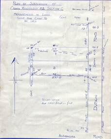 Ringwood and District Historical Society
Drawing - Plan of Subdivision of Crown Allotment 42, Section C, Ringwood, Vic (Undated), Hand-drawn outline of residential allotments in Dublin Road north of Alexandra Road, Ringwood East, Victoria
... Hand-drawn outline of residential allotments in Dublin Road ...Pen drawing on cardboard backing. -
Bendigo Historical Society Inc.
Map - KAMAROOKA ALLOTMENTS, 7/06/1894
... allotments ...Map: Parish of Kamarooka Allotments, County of Bendigo. Parish plan (number 288 in map cupboard 1)map, bendigo, allotments, kamarooka, allotments -
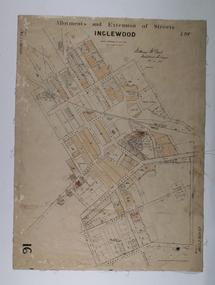 Bendigo Historical Society Inc.
Map - Map of Inglewood, July 23rd 1857
... Allotments ...Map of Allotments and Extension of Streets INGLEWOOD, light cream coloured background black ink, some allotments are highlighted with darker cream infills. On paper with cloth backing.map, township, allotments, inglewood -
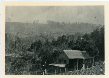 Mt Dandenong & District Historical Society Inc.
Photograph, Harry Child's Hut, early 1900s
Home of Harry Child in foreground built on the southern boundary of his father's (Francis Matthew Child) allotment. Black and white photograph showing the home of Harry Child. This photograph has a detailed inscription on the back handwritten by John Lundy-Clarke.The eastern face of Mt Dandenong from F.M. Childs selection Cnr allotment D.francis matthew child, mt dandenong, harry child -
Bendigo Historical Society Inc.
Map - HUNTLY ALLOTMENTS, No date visible
... allotments ...Map; Huntly Allotments, County of Bendigo. Parish plan (number 289 in map cupboard 1)map, bendigo, allotments, huntly allotments -
Bendigo Historical Society Inc.
Map - PARISH OF MARONG ALLOTMENTS, No date Visible
... allotments ...Map: Parish of Marong Allotments, County of Bendigo. Parish plan Blueprint (number 286 in map cupboard 1)map, bendigo, allotments, marong allotments -
Whitehorse Historical Society Inc.
Map, Parishes of Bulleen, Boroondara, Prahran and Nunawading, 1850
Photocopy of map and tables of corners of allotments.Photocopy of map and tables of corners of allotments. Note on verso: Nunawading, Boroondara, Prahran. Allotments in the Parish surveyed by Lindsay Clarke 1850 (note by Robert Hoddle, surveys by Unwin, Elgar and Dendy indicated)Photocopy of map and tables of corners of allotments. maps, parish of bulleen, parish of boroondara, parish of prahran, parish of nunawading, clarke, lindsay, hoddle, robert -
Whitehorse Historical Society Inc.
Map, Boroondara, Nunawading, 1853
Map of section of Parishes of Boroondara and NunawadingMap of section of Parishes of Boroondara and Nunawading with allotments numbered and named. Note on verso: Boroondara and Nunawading c1853.Map of section of Parishes of Boroondara and Nunawading maps, parish of nunawading, parish of boroondara -
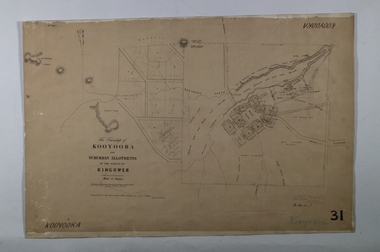 Bendigo Historical Society Inc.
Map - KOOYOORA, July 23rd 1857
... Allotments ...Map: The Township of Kooyoora and suburban allotments in the Parish of Kingower. This plan has been applied to a newer backingmap, township, kooyoora, allotments, parish of kingower