Showing 66 items matching "aqueduct bridge"
-
 Eltham District Historical Society Inc
Slide, Maroondah Aqueduct, Research, Victoria, 22 Mar. 1981
... at Greensborough and Bundoora where long lengths of the disused aqueduct... of the disused aqueduct have been demolished or filled in). The M.M.B.W ...An inspection tour of the Maroondah Aqueduct was undertaken by the Shire of Eltham Historical Society on Sunday, March 22nd, 1981, commening where the aqueduct crosses Main Rd., Research, just below Eltham College. The Maroondah Aqueduct was part of Melbourne’s water supply system. It carried water over the 66 km from the Maroondah Reservoir on the Watts River at Healesville to the Preston Reservoir. Of this length, 41 km were open channel, 10 km, tunnel through hills and 15 km in 14 inverted siphons across stream valleys. The route of the aqueduct is north of Tarrawarra and Yarra Glen, along the Yarra escarpment south of Christmas Hills and crossing Watsons Creek into the present Shire of Eltham near Henley Rd. The eastern part of the route lies entirely within the former boundaries of the shire. The aqueduct passes south of Kangaroo Ground to Research and crosses the Diamond Creek by siphon at Allendale Rd., Eltham North. It then extends to Reservoir via St. Helena, Greensborough North and Bundoora. Water first flowed through the aqueduct in February 1891 when it was fed by a diversion weir on the Watts River. Records of the building of the aqueduct indicate that it was a significant construction achievement. The present Maroondah Reservoir was completed in 1927 and the aqueduct was enlarged at that time to take increased flows. About 1971 the section of the aqueduct through and north of Research was replaced by a large pipe and that section of the channel is now unused. The channel has remained largely intact (unlike sections at Greensborough and Bundoora where long lengths of the disused aqueduct have been demolished or filled in). The M.M.B.W. relinquished control of the disused aqueduct reserve which is crown land and the Shire of Eltham took control of this section of the reserve as a linear park. The Maroondah Aqueduct is considered to be an important historic structure, not just to the local area but to the metropolitan area generally. It is considered important to preserve substantially intact long lengths of the disused aqueduct, together with its bridges and other associated structures. 35 mm colour positive transparency (1 of 5) Mount - Agfachrome Agfa CS System black 8 dotsactivities, heritage excursion, maroondah aqueduct, research (vic.), shire of eltham historical society -
 Eltham District Historical Society Inc
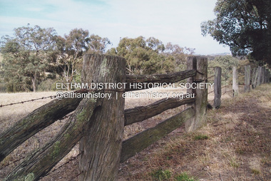
Photograph, Fay Bridge, Looking north towards Diamond Creek from the high point of Allendale Road, Diamond Creek, n.d
Situated opposite the driveway of 170 Allendale Road, Research, just east of where the Maroondah Aqueduct Trail crosses the roadfay bridge collection, allendale road, diamond creek, fences, research (vic.) -
 Eltham District Historical Society Inc
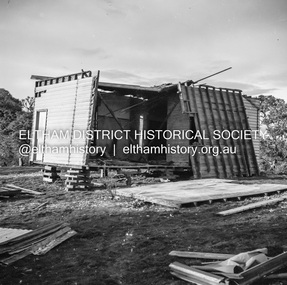
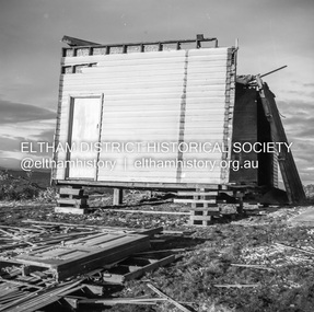
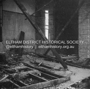
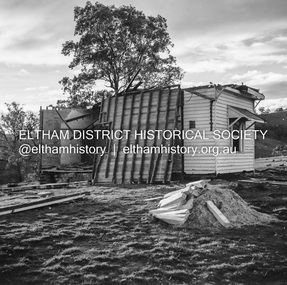
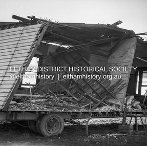
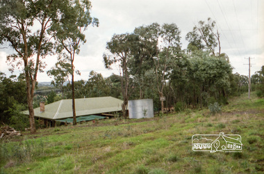
Negative - Photograph, J.A. McDonald, Inspection of storm damaged Abraham house at Kangaroo Ground, c. May 1962
Showing the effect of a wind storm that destroyed the house circa May 1962.. The Abraham family owned land near the Aqueduct and east of Nicholas Lane at Kangaroo Ground (based on photos, at or near 40 Nicholas Lane).Record of various Shire of Eltham infrastructure works undertaken during the period of 1952-1962 involving bridge and road reconstruction projects, sometimes with Eltham Shire Council Project Reference numbers quoted. It was during this period that a number of significant improvements were made to roads and new bridges constructed within the shire that remain in place as of present day (2022). In many situations, the photos provide a tangible visible record of infrastructure that existed throughout the early days of the Shire. The album was put together by or under the direction of the Shire Engineer, J.A. McDonald.1962-05, abraham house, kangaroo ground, nicholas lane, property damage, storm damage -
 Eltham District Historical Society Inc
Negative - Photograph, J.A. McDonald, Inspection of storm damaged Abraham house at Kangaroo Ground, c. May 1962
Showing the effect of a wind storm that destroyed the house circa May 1962.. The Abraham family owned land near the Aqueduct and east of Nicholas Lane at Kangaroo Ground (based on photos, at or near 40 Nicholas Lane).Record of various Shire of Eltham infrastructure works undertaken during the period of 1952-1962 involving bridge and road reconstruction projects, sometimes with Eltham Shire Council Project Reference numbers quoted. It was during this period that a number of significant improvements were made to roads and new bridges constructed within the shire that remain in place as of present day (2022). In many situations, the photos provide a tangible visible record of infrastructure that existed throughout the early days of the Shire. The album was put together by or under the direction of the Shire Engineer, J.A. McDonald.1962-05, abraham house, kangaroo ground, nicholas lane, property damage, storm damage, building surveyor, george e. newton -
 Eltham District Historical Society Inc
Negative - Photograph, J.A. McDonald, Inspection of storm damaged Abraham house at Kangaroo Ground, c. May 1962
Showing the effect of a wind storm that destroyed the house circa May 1962.. The Abraham family owned land near the Aqueduct and east of Nicholas Lane at Kangaroo Ground (based on photos, at or near 40 Nicholas Lane).Record of various Shire of Eltham infrastructure works undertaken during the period of 1952-1962 involving bridge and road reconstruction projects, sometimes with Eltham Shire Council Project Reference numbers quoted. It was during this period that a number of significant improvements were made to roads and new bridges constructed within the shire that remain in place as of present day (2022). In many situations, the photos provide a tangible visible record of infrastructure that existed throughout the early days of the Shire. The album was put together by or under the direction of the Shire Engineer, J.A. McDonald.1962-05, abraham house, kangaroo ground, nicholas lane, property damage, storm damage -
 Eltham District Historical Society Inc
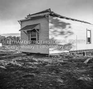
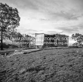
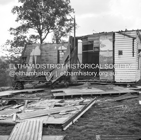
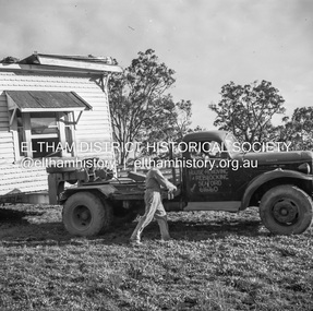
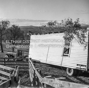
Negative - Photograph, J.A. McDonald, Removal of the remains of the Abraham house at Kangaroo Ground, c. May 1962
Martin Bros House Removing of Seaford was contracted to remove the remains of the storm damaged Abraham house from the property circa May 1962. The Abraham family owned land near the Aqueduct and east of Nicholas Lane at Kangaroo Ground (based on photos, at or near 40 Nicholas Lane).Record of various Shire of Eltham infrastructure works undertaken during the period of 1952-1962 involving bridge and road reconstruction projects, sometimes with Eltham Shire Council Project Reference numbers quoted. It was during this period that a number of significant improvements were made to roads and new bridges constructed within the shire that remain in place as of present day (2022). In many situations, the photos provide a tangible visible record of infrastructure that existed throughout the early days of the Shire. The album was put together by or under the direction of the Shire Engineer, J.A. McDonald.1962-05, abraham house, kangaroo ground, martin bros house removing seaford, nicholas lane, property damage -
 Eltham District Historical Society Inc
Folder, Pioneers & Painters; Shire of Eltham Historical Society notes, minutes, 1969-1971, 1969-1971
Material pertaining to the production of a history of the Shire of Eltham, "Pioneers & Painters: One Hundred Years of Eltham and its Shire" in recognition of the shire's centenary in 1971 Item Title Caption 04766-1 Background to publication of a Shire Centenary book from another shire, 7 February 1969 04766-2 Outcomes of Annual General Meeting held 11 February 1969, Shire of Eltham Historical Society, Advising office bearers for 1969 as well as notice for next meeting to be held 11 March 1969 at the Eltham War Memorial Hall where guest speaker Alan Marshall will talk on a proposal to compile a history of the Shire of Eltham to be published for the centenary of the Shire in 1971 04766-3 Letter: Russell Yeoman, Secretary, Shire of Eltham Historical Society to the Shire Secretary, Shire of Eltham seeking financial support for the publication of a history of the shire to celebrate its centenary in 1971, 21 February 1969 04766-4 Carbon copy Letter: Russell Yeoman, Secretary, Shire of Eltham Historical Society inviting Shire Councillors to next Historical Society meeting, 21 February 1969 Enclosed copy of letter sent to Shire Secretary, Shire of Eltham seeking financial support for the publication of a history of the shire to celebrate its centenary in 1971 04766-5 Notes following meeting with Alan Marshall regarding the publication of a history of the Shire of Eltham, 1969 In Russell Yeoman's hand writing 04766-6 Letter: M.B. Watson, Eltham Shire Secretary to Shire of Eltham Historical Society expressing support for the publication of a history of the Shire, 11 March 1969 04766-7 Alan Marshall's notes for talk to members of the Shire of Eltham Historical Society (March 1969) re research for Shire history publication, c.March 1969 04766-8 Minutes of the meeting of the Shire of Eltham Historical Society held 11 March 1969 04766-9 Letter: Russell Yeoman, Secretary, Shire of Eltham Historical Society to F. Endacott, President of Healesville Historical Society seeking information for the publication of a history of the shire to celebrate its centenary in 1971, 10 June 1969 Areas of Healesville were initially part of the Shire of Eltham 04766-10 Letter: Page 1 of letter from F. Endacott, President, Healesville Historical Society, to Russell Yeoman regarding the history of the Shire of Eltham extending beyond Healesville, 21 June 1969 04766-11 Notice to members of the Shire of Eltham Historical Society regarding publication of a history of the Shire to be edited by Alan Marshall and advising next meeting to be held 24 June 1969 04766-12 Letter: RHSV to Shire of Eltham Historical Society agreeing to place any source material at the disposal of the society for the upcoming publication on the history of the Shire of Eltham, 30 June 1969 04766-13 Letter: Russell Yeoman, Secretary , Shire of Eltham Historical Society to Melbourne & Metropolitan Board of Works seeking material for a history of the Shire. c.1969 Specific mention regarding the Maroondah Aqueduct 04766-14 Letter: Russell Yeoman, Secretary , Shire of Eltham Historical Society to Peter Cuffley of Hamilton seeking material for a history of the Shire. 8 July 1969 Specific mention regarding Sweeneys 04766-15 Letter: Rev. Donald Longfield to Russell Yeoman regarding potential sources of information and photographs for a history of the Shire of Eltham, 9 July 1969 04766-15-2 Letter: Rev. Donald Longfield to Russell Yeoman regarding potential sources of information and photographs for a history of the Shire of Eltham, 9 July 1969 04766-15-3 Letter: Rev. Donald Longfield to Russell Yeoman regarding potential sources of information and photographs for a history of the Shire of Eltham, 9 July 1969 04766-16 Letter: Russell Yeoman, Secretary , Shire of Eltham Historical Society to Royal Historical Society of Victoria seeking assistance on material for a history of the Shire. c.1969 Specific mention regarding the Maroondah Aqueduct 04766-17 Letter: Russell Yeoman, Secretary , Shire of Eltham Historical Society to the Editor, RHSV Newsletter on the Society seeking material for a history of the Shire. 24 July 1969 04766-18 Notice and Agenda for Shire of Eltham Historical Society Meeting to be held 26 August 1969 Peter Basset-Smith to show his films of Eltham & District in the 1930s 04766-19 Letter: L.J. Corben, Acting Assistant Secretary, Melbourne & Metropolitan Board of Works to Russell Yeoman, Secretary , Shire of Eltham Historical Society regarding availability of material on the Maroondah Aqueduct and Dam in support of a publication on the history of the Shire, 29 August 1969 Specific mention regarding the Maroondah Aqueduct 04766-20 Notice for Shire of Eltham Historical Society Meeting to be held 23 August 1969 Peter Basset-Smith to show his films of Eltham & District in the 1930s 04766-21 Notice of cancellation for Shire of Eltham Historical Society Meeting to be held October 1969 04766-22 Notice for Shire of Eltham Historical Society Meeting to be held 25 November 1969 04766-23 Notes regarding Shire of Yea's plans to publish a book on the shire's history for its centenary in 1969 04766-24 Draft notice for call-out of historical photographs and documents in support of a publication on the history of the Shire of Eltham, 1969 04766-25 Notes from meeting of Shire of Eltham Historical Society, History Publication Committee meeting, c.1969 04766-26 Note to Russell Yeoman advising sources of printed material, photographs, etc for Pioneers & Painters - A History of Eltham Shire, c.1969 04766-27 Letter: Russell Yeoman, Secretary , Shire of Eltham Historical Society to Heidelberg Historical Society seeking material for a history of the Shire. c.1969 Specific mention regarding floods in the area and the Heidelberg School of Painters 04766-28 Letter: Russell Yeoman, Secretary , Shire of Eltham Historical Society to Doncaster Historical Society seeking material for a history of the Shire. c.1969 Specific mention regarding Warrandyte and recent Fitzsimons Lane bridge 04766-29 Notice for Shire of Eltham Historical Society Meeting to be held 27 January 1970 04766-30 Notice for Shire of Eltham Historical Society Annual General Meeting to be held 24 February 1970 04766-31 Notice of Office Bearers elected at the Shire of Eltham Historical Society Annual General Meeting held 24 February 1970 and notice of next meeting to be held 24 March 1970 04766-32 Notice for Shire of Eltham Historical Society Meeting to be held 28 April 1970 04766-33 Notice from Russell Yeoman, Secretary, Shire of Eltham Historical Society to members advising on progress of the History Publication Committee, c. 1970 Also noted, the Society has a new P.O. Box address; P.O. Box 37 Eltham Vic. 3095 04766-34 Letter: Draft copy of letter from Russell Yeoman, Secretary, Shire of Eltham Historical Society expressing appreciation to Cr. Charis Pellis for chairing the committee which led to the publication of Pioneers & Painters, 23 August 1971 04766-35 Letter: Mrs Stella Graham of Diamond Creek to Secretary Shire of Eltham Historical Society, 1971; requesting the return of her personal papers lent in conjunction with the compilation of the history of the Shire of Eltham 04766-36 Letter: Mrs Stella Graham of Diamond Creek to Alan Marshall, 3 Aug. 1971; requesting the return of her personal papers lent in conjunction with the compilation of the history of the Shire of Eltham 04766-37 Letter: Margaret Orford of Nhill to Alan Marshall, 7 Feb 1970; advising she cannot help with any photos. Her Uncle who Alan Marshall had interviewed had all memorabilia however she definitely wanted to buy a book when available.The idea to develop a book on the history of the Shire of Eltham to be edited by noted author, Alan Marshall in celebration of the shire's centenary was initiated in 1969. The Shire of Eltham Historical Society undertook significant research in conjunction with Alan Marshall locating material at various institutions and other societies; interviewing longer term residents and a public campaign through the local press to acquire photographic material for duplication and use in the book. The public campaign received generous response and the material collected became the genesis for the Shire of Eltham Pioneers Photograph collection now held in partnership between Eltham District Historical Society and Yarra Plenty Regional Library (Eltham Library).Miscellaneous notes, copies of letters and minutes of the Shire of Eltham Historical Societyalan marshall, apted, arthurs creek, bridge street, burgoyne, cr. charis pelling, cracknell, dan glasgow, donald longfield, doncaster historical society, elsie reynolds, ethel williams, fitzsimons lane bridge, floods, frank berkery, heidelberg historical society, history publication committee, joslyn, kath stephenson, maroondah aqueduct, minutes, mmbw, motschall, panton hill, pioneers and painters, research (vic.), rev. jock ryan, rev. ken briarty, rev. longfield, rhsv, royal historical society of victoria, russell yeoman, shire of eltham historical society, shire of eltham, shire of eltham pioneers photograph collection, smith, stella graham, sweeney, yea shire council, margaret orford -
 Greensborough Historical Society
Photograph - Digital Image, Marilyn Smith, Plenty River at the aqueduct crossing Greensborough 2019, 02/07/2019
The Plenty River at the aqueduct crossing, 2019, showing graffiti on the river bank rocks. Originally part of the Maroondah Aqueduct pipeline, all that remains is the bridge that once carried the pipe over the Plenty River. This photograph was taken from the Plenty River Trail in Greensborough. 2 colour digital photographsplenty river trail, maroondah pipetrack, maroondah aqueduct, plenty river, graffiti -
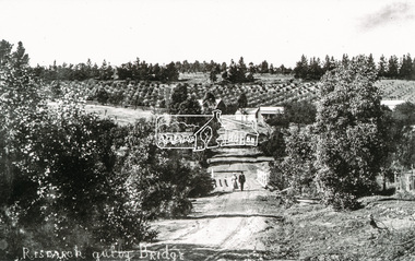
 Eltham District Historical Society Inc
Photograph, Tom Prior, Research Gully Bridge, Research Gully Road, Research, c.1895
... bridge research gully road aqueduct reynolds prior collection ...Research Gully Bridge. At time of collection (1970) Ingrams Road was formerly Research Gully Road.This photo forms part of a collection of photographs gathered by the Shire of Eltham for their centenary project book,"Pioneers and Painters: 100 years of the Shire of Eltham" by Alan Marshall (1971). The collection of over 500 images is held in partnership between Eltham District Historical Society and Yarra Plenty Regional Library (Eltham Library) and is now formally known as the 'The Shire of Eltham Pioneers Photograph Collection.' It is significant in being the first community sourced collection representing the places and people of the Shire's first one hundred years. The Reynolds family were early settlers in Research. The Reynolds/ Prior collection of photographs were taken by Tom Prior, the maternal uncle of Ivy Reynolds, around 1900 and the 60 photos in the album give a fine overview of many of the landmarks of Research and Eltham over 100 years ago. lvy lived in the family home for many years at 106 Thompson Cres Research. Ivy's father, Ernst Richard Reynolds and grandfather, Richard Reynolds, lived at the same address. Ivy's father Richard worked for Mr. Trail on his property in Research. Reynolds Road is named after the family. Mr Tom Prior (wife Eva) worked at the Melbourne zoo. He was very innovative and made his own camera, using the black cloth hood to exclude the light. The photographs are a reminder of the rural nature of Research and Eltham and its rich heritage.Digital imageshire of eltham pioneers photograph collection, research (vic.), ingrams road, research gully bridge, research gully road, aqueduct, reynolds prior collection -
 Eltham District Historical Society Inc
Photograph, Russell Yeoman, Parsons Road Bridge over the Aqueduct
... Parsons Road Bridge over the Aqueduct... melbourne parsons road bridge maroondah aqueduct Kodak Safety 5035 ...Roll of 35mm colour negative film, 5 stripsKodak Safety 5035parsons road, bridge, maroondah aqueduct -
 Eltham District Historical Society Inc
Photograph, Parsons Road Bridge over the Aqueduct, Eltham, c. Jan 1986, January 1986
... Parsons Road Bridge over the Aqueduct, Eltham, c. Jan 1986... melbourne maroondah aqueduct parsons road Kodak CL 200 5093 Roll ...Roll of 35mm colour negative film, 3 stripsKodak CL 200 5093maroondah aqueduct, parsons road -
 Eltham District Historical Society Inc
Photograph, Aqueduct Trail just near Parsons Road Bridge, Eltham, c. Jan 1986, January 1986
Roll of 35mm colour negative film, 3 stripsKodak CL 200 5093maroondah aqueduct, parsons road -
 Eltham District Historical Society Inc
Photograph, 35 Ingrams Road, Research, Eltham Heritage Tour, 24 May 1992, 24/05/1992
ELTHAM HERITAGE TOUR The Society excursion on 24th May 1992 was arranged by David Bick, leader of the team carrying out the Shire's heritage study. David selected a number of sites or buildings identified in the study, some of them lesser known components of the Shire's heritage. The tour commenced at the Eltham Shire Office at 10.00 am. Travel was by private car and mini-bus with stops at about twelve locations for commentary by David.It included a short walk in Hurstbridge and lunch at Kinglake. Highlights of the tour included: - 10 am Leave from Shire Offices - 3 Important Trees - A Physical Link to Eltham's First Settlers - Toorak Mansion Gates - A Surviving Farm House - An Intact Circa 1900 Main Street - First Settlers - Gold Miners, and Timber-getters - An Early Hotel - A Pioneering Homestead - Changing Eltham Shire - 20th Century - 4 pm Afternoon Tea and Finish Tour Extract from ELTHAM CULTURAL HERITAGE TOUR (Newsletter No. 85, July 1992, by Bettina Woodburn) "On a right-angle turning of the Eltham Road is Wellers Pub, a Cobb & Co. coaching stop on the way to distant gold-fields and places north of the Yarra River. The Hotel dates from the 1870's. Daily distances for a bullock team was eight miles, horses could do double that distance. We turned into Cassells Road and on the corner of Ingrams Road we admired an elaborate Edwardian villa, 1900 style. The Aqueduct conveying Melbourne's water supply was a communication line and a technological advance in 1891. It has been enlarged and re-faced and no longer used here but piped underground. Proclaimed a linear park it has reverted to crown land, controlled by local Council. Maroondah Dam was constructed in. 1920 to replace the original weir and at that time: the Aqueduct - as established into the landscape - with bridges and tunnels and pine trees were used to stop rubbish polluting the water."Record of the Society's history and activities and highlighting various aspects of the Heritage Study undertaken by David Bick used to create the future heritage overlay for the Shire of Eltham and later Nillumbik Shire.Roll of 35mm colour negative film, 4 stripsKodak Gold 100 5095shire of eltham historical society, activities, heritage tour, ingrams road, research (vic.) -
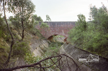
 Eltham District Historical Society Inc
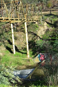
Photograph, Liz Pidgeon, Heritage Excursion; Maroondah Aqueduct, 3 September 2016, 3 September 2016
... bridge on Parsons road, Eltham North over the aqueduct ...Heritage Excursion - Maroondah Aqueduct Walk - Saturday 3rd September The Maroondah Aqueduct was once a major link in Melbourne’s water supply system. It was built between 1886 and 1891 to transfer water from the Watts River near Healesville to the Preston Reservoir. It was 66 km in length, made up of 41 km of open channel, 10 km of tunnel through hills and 15 km of pipeline across stream valleys known as inverted siphons. The section of the aqueduct through the Eltham area has been abandoned since the 1980s but the open channel has largely been retained. A recreational path follows the aqueduct reserve. For our excursion on 3rd September we intend to walk along the section of the aqueduct adjacent to Allendale Road. This is a section not visited on previous excursions and includes the transition from open channel to the inverted siphon across the Diamond Creek valley. Apart from the aqueduct itself the main feature of the walk is the extensive views across Eltham North and Diamond Creek. Along the way we will talk about the history of the aqueduct and the area. This easy walk is about 3 km return and will take 2 to 2.5 hours. It will start at 2pm at the junction of Allendale Road with Godber Road and Zig Zag Road North, officially Diamond Creek, but on the northern boundary of Eltham. (Melway ref.12 B10). Newsletter No., 229, August 2016 Brick bridge on Parsons road, Eltham North over the aqueduct on the aqueduct trail. Born Digitalmaroondah aqueduct, eltham north, activities, eltham district historical society, heritage excursion, parsons road, bridges, aqueduct trail -
 Eltham District Historical Society Inc
Photograph, Tom Prior, Research Gully Bridge, Research Gully Road, Research, c.1895
Research Gully Bridge. At time of collection (1970) Ingrams Road was formerly Research Gully Road. The Maroondah Aqueduct runs along the base of the pine trees.The Reynolds family were early settlers in Research. The Reynolds/ Prior collection of photographs were taken by Tom Prior, the maternal uncle of Ivy Reynolds, around 1900 and the 60 photos in the album give a fine overview of many of the landmarks of Research and Eltham over 100 years ago. lvy lived in the family home for many years at 106 Thompson Cres Research. Ivy's father, Ernst Richard Reynolds and grandfather, Richard Reynolds, lived at the same address. Ivy's father Richard worked for Mr. Trail on his property in Research. Reynolds Road is named after the family. Mr Tom Prior (wife Eva) worked at the Melbourne zoo. He was very innovative and made his own camera, using the black cloth hood to exclude the light. The photographs are a reminder of the rural nature of Research and Eltham and its rich heritage. Black and white photograph mounted in an album, the Reynolds/Prior Photograph Collection, this being one of 53 reproduced black and white images of early Eltham. (Duplicated on p38 also)The Reynolds/Prior Photograph Collection, Presented to the Eltham District Historical Society, 14 June 2006 by Ross McDonald. A second copy was also presented to the Andrew Ross Museum, Kangaroo Groundaqueduct, ingrams road, research (vic.), research gully bridge, research gully road, reynolds prior collection, shire of eltham pioneers photograph collection, bridge -
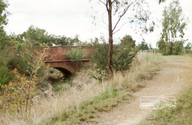
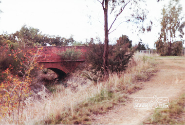 Eltham District Historical Society Inc
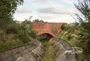
Photograph, Parsons Road bridge over former Maroondah Aqueduct
... Parsons Road bridge over former Maroondah Aqueduct...Colour photograph of Parsons Road bridge over disused... aqueduct bridges Colour photograph of Parsons Road bridge over ...Colour photograph of Parsons Road bridge over disused Maroondah Aqueductparsons road, eltham north, research, aqueducts, maroondah aqueduct, bridges -
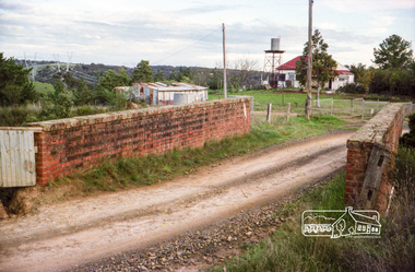
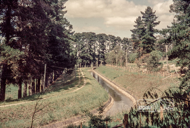 Eltham District Historical Society Inc
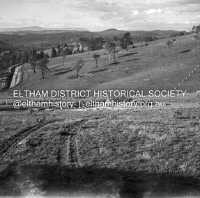
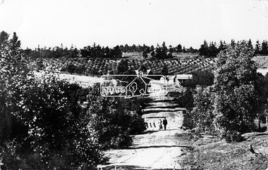
Photograph, Russell Yeoman, Maroondah Aqueduct, Research, c.1979, 1979c
Looking west, The Esplanade to the right and Ingrams Road Bridge in centre distance. Digital file only; created from original colour positive slide transparencymaroondah aqueduct, research (vic.), ingrams road, the esplanade, russell yeoman collection