Showing 243 items matching "atlas"
-
 Flagstaff Hill Maritime Museum and Village
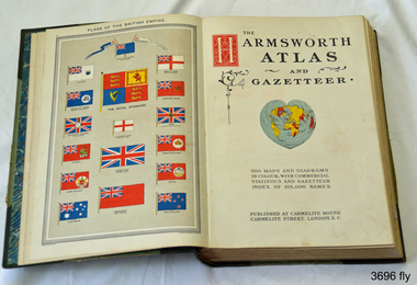
Book, Harmsworth Atlas and Gazetteer, 1908
This Harmsworth Atlas and Gazetteer was inherited by one of the donors, a gift from her father who was Tasmanian.Large hard covered book with maps, charts and tables. The cover is green linen with green leather, gilt trimmed corners and decorative spine, It includes 500 maps and diagrams in colour, with commercial statistics and gazetteer index of 105,000 names. Jan 1908. Also inserted between the pages of the book were 2 folded sheets of waxed paper, each with carefully placed flowers pressed between them; native orchids and wattle. Published at Carmelite House, Carmelite Road, London flagstaff hill, warrnambool, shipwrecked coast, flagstaff hill maritime museum, maritime museum, shipwreck coast, flagstaff hill maritime village, great ocean road, harmsworth atlas and gazetteer, atlas 1908, maps 1908, gazetteer 1908, book 1908, pressed australian native flowers, pressed wattle, pressed orchid -
 Yarrawonga and Mulwala Pioneer Museum
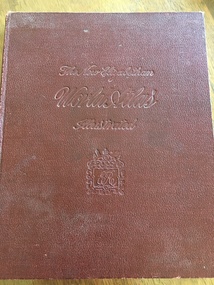
Book, The Specialty Press, The New Elizabethan World Atlas Illustrated, 1952
Provides names of countries and their borders as they were during the 1950'sMaroon hard cover illustrated atlas. Front embossed with title and royal seal. 152 pages. Contains detailed maps of world countries in colour. Early world history and it's development and comprehensive gazetteer.Owners name written in front pagesmaps -
 Greensborough Historical Society
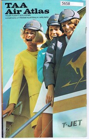
Booklet, TAA Air Atlas, 1972_
Souvenir publication, detailing airline routes, services and aircraft. TAA air atlas: your flight souvenir, compliments of Trans-Australia Airlines.16 p., printed in colour, maps, photographs and text.airlines, trans-australia airlines -
 Federation University Historical Collection
Globe, Atlas Projector Tube Globe
Boxed globeprojector, globe, tube, atlas -
 Ballarat Clarendon College
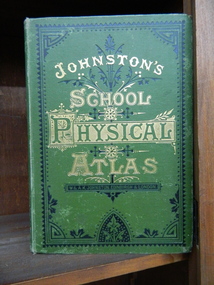
Book, School atlas of physical geography
Robert Mitchell attended Ballarat College 1879The book was printed in 1878 year, The place of publication of the book is W & A K Johnston, Edinburgh and London, 1878. A School Atlas of Physical Geography. Book in English language. Book has cover wear and fading, modest foxing to plates. Some plates are missingHandwritten on flyleaf: R. A Mitchell July 1878 / Ballarat / RAM -
 Victorian Aboriginal Corporation for Languages
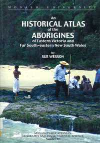
Book, Sue Wesson, An historical atlas of the Aborigines of Eastern Victoria and Far South-eastern New South Wales, 2000
An extremely detailed atlas of tribes, clans, and languages in eastern Victoria and south-eastern New South Wales. Includes maps, census information about the numbers and makeup of these clans in historical records, meanings and comparative spellings of all known named tribes and clans.maps, b&w photographs, colour photographs, tables -
 Warrnambool and District Historical Society Inc.
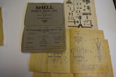
Documents, Atlas Automatic Fire Services Pty Ltd, Woollen Mill, late 20th century
These items are from the Warrnambool Woollen Mill and relate to the fire protection services operating at the factory in the late 20th century. The Warrnambool Woollen Mill was commenced as a local public company and opened in 1910 in South Warrnambool with the first manager, John Bennett. During World War Two there were 700 employees at the mill due to wartime demand. In 1958 the factory became the first in Australia to manufacture electric blankets. In 1968 the mill was purchased by the Dunlop company and in 1982 Dunlop sold out to Onkaparinga Woollen Company which was taken over by Macquarie Worsteds and became known as Warrnambool Textiles. When Macquarie Worsteds ceased operations in Warrnambool the Smith Family managed the factory on behalf of the owners, the Warrnambool City Council. In 2000 the Woollen Mill closed and the site has been sold and developed as a housing estate.These items are of minor interest as mementoes of the Warrnambool Woollen Mill and will be added to the Woollen Mill collection in the Historical Society archives. .1 A sheet of white paper showing a sketch plan in black of the Warrnambool Woollen Mill with three areas coloured pink, yellow and blue .2 the same as .1 except that there are no shaded areas. .3 A sheet of lightweight card with black and yellow printing and a diagram of a machine Fire Plan For Insurance Purposes Atlas Automatic Fire Services Pty Ltd warrnambool woollen mill, history of warrnambool, onkaparinga woollen company, dunlop company -
 Glenelg Shire Council Cultural Collection
Book, Illustrated Bible Geography and Atlas, n.d
religion; atlas; geography; Bible; Judah; Israel;Book, 'Illustrated Bible Geography and Atlas'. red card covers, white banner with red print. Map of Judah and Israel in white on front cover. 32 pages on geography of the Bible; 16 pages of coloured maps, most in biblical times; 8 black and white photos of Jerusalem.religion; atlas; geography; Bible; Judah; Israel; -
 Flagstaff Hill Maritime Museum and Village
Book, Coltons General Atlas
Colton's General Atlas Date: 1866 Register of Authorised Copies of the Standard Weights and Measures Issued The Centre page of the Book has the heading of "Register of Authorised Copies of The Standard Weights and Measures Issued 1866." All front half pages are stapled together. All back half pages are stapled together. No Markingsflagstaff hill, warrnambool, maritime village, maritime museum, shipwreck coast, great ocean road, coltons general atlas, weights and measures -
 Marysville & District Historical Society
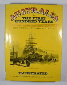
Book, IPC Books Pty Limited, Australia-The First Hundred Years-Being a facsimile of Volumes I & II of the Picturesque Atlas of Australia-1888, 1886
The Picturesque Atlas was designed to give a graphic and summarised conception of Australasian history and life from the days of the earliest Portuguese, Spanish, Dutch, English and French navigators to the 1880's, embracing such salient events as the landing of Captain Cook in 1770. the discoveries of voyagers, explorers an pioneer missionaries; the founding of the different colonies; the establishment of representative government and the marvellous political, commercial and social development which characterises the people of Australia.Dust cover has an illustration depicting Circular Quay, West Side in the early days of Australia.non-fictionThe Picturesque Atlas was designed to give a graphic and summarised conception of Australasian history and life from the days of the earliest Portuguese, Spanish, Dutch, English and French navigators to the 1880's, embracing such salient events as the landing of Captain Cook in 1770. the discoveries of voyagers, explorers an pioneer missionaries; the founding of the different colonies; the establishment of representative government and the marvellous political, commercial and social development which characterises the people of Australia.history, australia, explorers, voyagers, missionaries, politics, commercial development, social development -
 Whitehorse Historical Society Inc.
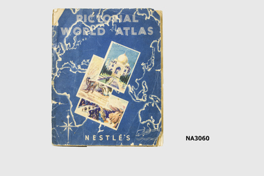
Book
Nestles had a small chocolate bar dispenser on railway station from which for one penny inserted in the dispenser you received a chocolate bar with a coloured card. Card could be inserted in album in a space reserved for that card in the country it referred to.|Album was given to Dianne Warren, daughter of donor, by her cousin whose father had a sweet shop in Glenferrie.Pictorial World Atlas - a Nestles collectors album of cards of various country's of the world. See History.Nestles Pictorial World Atlasbooks, collections -
 Wangaratta High School
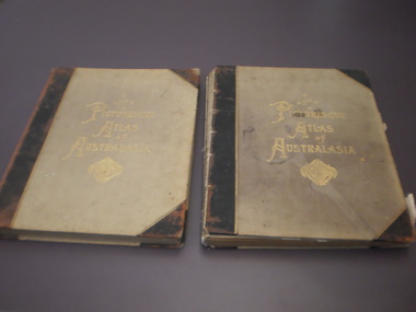
WHS Textbook, 1887
Two hardcover felt lined atlases with black reinforced spines and corners. Gold writing and symbol in the centre of the cover reads The PICTURESQUE ATLAS of AUSTRALASIA. Volumes 1 and 3 are in the school's collection. each book has some degree or wear, with torn pages and peeling paper in some areas, and one has a large water mark on the cover.The PICTURESQUE ATLAS of AUSTRALASIA -
Friends of St Brigids Association
Book - An Atlas of Irish History, Edwards, Ruth Dudley. 1989. An Atlas of Irish History. London ; New York : Methuen, 1981 1 atlas (286 p.) : maps ; 24 cm
-
 Bendigo Military Museum
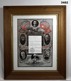
Certificate - SHIRE OF TULLAROOP, FRAMED, Post WW1
Item relates to John Stanley HOWLETT No 2676 AIF. Refer Cat No 41 for his service history.Certificate of Appreciation by the Citizens of the Shire of Tullaroop to Pte John S Howlett No 2676 59th Battalion AIF 1914-5-6. Black & white certificate with red and white flags at top. 6 x dignitaries of the day are pictured. White border mounted, glass front, timber frame with gold inner border & ply backing.certificates, framed, shire -
 Bendigo Historical Society Inc.
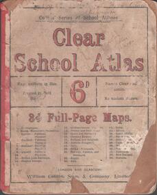
Book - SCHOOL ATLAS, 1880s
Atlas. 34 page 'CLEAR SCHOOL ATLAS' in colour. Price sixpence. On the map of Australia, page 32, the location of Sandhurst is shown. Handwritten in ink at top of front cover, 'Fifth Class, Bamawm'William Collins, Sons & Company, London and Glasgoweducation, bendigo, atlas, bamawm, sandhurst -
 Stawell Historical Society Inc
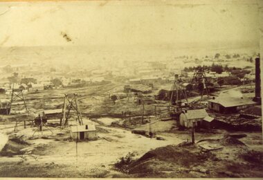
Photograph, Working Mines with Stawell in background
Stawell Mining Scene "The Picturesque Atlas of Australasia" edited by the Hon Andrew Garran MLC B/W photograph an an engraving on wood. One of the mines is Scothman's United. Copied from "The Picturesque Atlas Of Australasia" stawell -
 Stawell Historical Society Inc
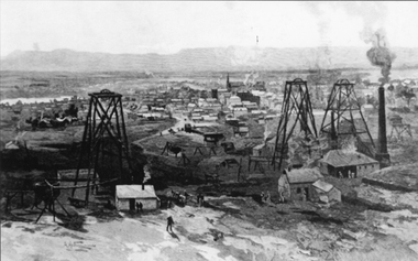
Photograph, Drawing of working Mines with Stawell in background
Stawell Mining Scene "The Picturesque Atlas of Australasia" edited by the Hon Andrew Garran MLC B/W photograph an an engraving on wood. One of the mines is Scothman's United. Copied from "The Picturesque Atlas Of Australasia" stawell -
 Royal Australian and New Zealand College of Obstetricians & Gynaecologists (RANZCOG)
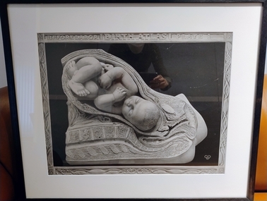
Print - Reproduction print of plate from 'Birth atlas', Maternity Center Association, 1943, Robert Latou Dickinson et al, Plate 8. Before labour, 1943
A series of six prints showing various stages of labour, donated to the College in 2000.Black and white reproduction print of a plate from a book, enclosed in a wooden frame. Text at the top of the print reads 'BEFORE LABOR | BIRTH ATLAS | PLATE 8'. The plate depicts a detailed cross section image of a baby in the womb. Label attached to back of work reads: 'Robert Latou DICKINSON and Abram BELSKI/ Plate 8. Before labour/From: Birth atlas: reproduction of twenty-four life size sculptures of fertilization, growth,/stages of labour and involution./New York: Maternity Center Association, 1943. 6th ed./Gift of St Georges Hospital, Kew, 2000'.BEFORE LABOR | BIRTH ATLAS | PLATE 8obstetric delivery -
 Bendigo Military Museum
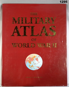
Book, Chris Bishop, The Military Atlas of World War II, c.2005
Red, hard cover with red loose paper jacket, map of world on front (circular, in colours mainly white), gold & white print, black print on inside cover. Colour illustrations & photographs throughout, 176 pages.books, military history -
Phillip Island and District Historical Society Inc.
Book, FARRELL, David, Atlas of first aid, 1940
Stamped 'McGill's Agency etc.'. Inscribed 'Ita Gallagher, 1 Launder St., Hawthorn'. -
Phillip Island and District Historical Society Inc.
Book, WEBSTER, D.L, Encyclopedia of useful information and world's atlas, 1889
Stamped 'Phillip Island & District Historical Society'. -
Phillip Island and District Historical Society Inc.
Book, William Collins, library atlas : consisting of one hundred and ten maps of modern, historical, and classical geography, &c., with descriptive letterpress of Modern geography by James Bryce, Historical geography by William F. Collier, Classical geography by Leonard Schmitz; with copious indices, 1876?
Inscribed: Hazel Fair, 37 Laura St., E. Bruns. N. 10. Stamped: J.R. Mann, Bookseller, Victoria Market ; Phillip Island & District Historical Society -
Phillip Island and District Historical Society Inc.
Book, W. & A.K. Johnston, world-wide atlas of modern geography, political and physical, containing one hundred and twenty-eight plates and complete index with an introduction by J. Scott Keltie, 1906
-
Phillip Island and District Historical Society Inc.
Book, BARTHOLOMEW, John, Black's general atlas of the world, 1860
Book from the Cleeland Bequest - a comprehensive collection of books relating to the History of England, Civil & Military, Religious, Intellectual & Social. Labelled 'Cowes Free Public Library', 'Phillip Island Historical Society, Cleeland Bequest'. Inscribed 'Jno Cleeland'.cleeland bequest -
Phillip Island and District Historical Society Inc.
Book, F.E. Hiscocks &? Co, F.E. Hiscocks &? Co.'s new Victorian counties atlas, 1874 [cartographic material] : together with map of Victoria, indicating roads, distances, relative position of counties, &?c, 1874
Labelled 'Cowes Free Public Library', 'Phillip Island Historical Society, Cleeland Bequest'.victoria, maps -
 Glenelg Shire Council Cultural Collection
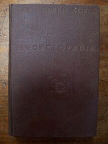
Book - Book -s - The Modern World Encyclopaedia Vol,1, 7,8 and 9, 519.1 - The Modern World Encyclopaedia. Vol 1: A-BED519.2 - The Modern World Encyclopaedia. Vol 7: OBE-SHA519.3 - The Modern World Encyclopaedia. Vol 8: SHA-ZYG519.4 - The Modern World Encyclopaedia. Vol 9: World Atlas, 1935
Brown cloth-covered cardboard covers and spine. Gold text on spine. Title impressed on cover. -
 Federation University Historical Collection
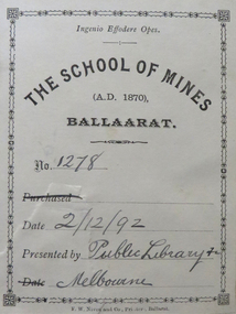
Book, John Ferres, Government Printer, Eucalyptographia : a Descriptive Atlas of the Eucalypts of Australia and Adjoining Islands, 1883-4, 1883 and 1884
Ferdinand Von Mueller was the Government Botanist for the Colony of Victoria. He was an early examiner in Botany at the Ballarat School of Mines. The book was donated to the Ballarat School of Mines by the Melbourne Public Library. The Bookplate in the front states the book is number 1278 in the Ballarat School of Mines Library and was presented on 02/12/1892.Two books (ninth and tenth decade) with soft cover and blue tape spine. Includes text and black and white images relating to Eucalypts .1) includes a bookplatebotany, ferdinand von mueller, ballarat school of mines, eucalypts, botanist, bookplate, melbourne public library, state library of victoria -
 Federation University Historical Collection
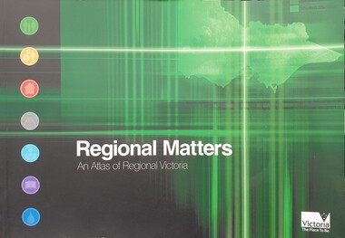
Book, Department of Infrastructure, Regional Matters: An Atlas of Regional Victoria, C2003
Green soft covered book including chapers on population, jobs and industry, housing, road and rail transport, health services, education, and water resourcesvictoria, regional victoria, population, migration flow, jobs, industry, export, food production, housing, rail, roads, health, education, qualifications, water, irrigation -
 Monbulk RSL Sub Branch
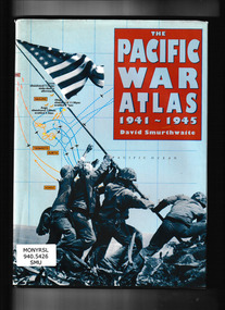
CIS, The Pacific War Atlas 1941-1945, 1995
Traces the campaign in the Pacific in detail, from its conception through the dropping of the atomic bombs on Hiroshima and Nagasaki. It brings a new clarity to the disposition of military units in all major battles and to the complicated web of strategic problems posed by fighting over such a huge area. Special map projections, perspective views and sophisticated treatment of time phases recreate the action from both Allied and Japanese viewpoints. Includes more than 60 full-color maps combining topographical detail with troop movements.Index, bibliography, ill, maps, p.141.non-fictionTraces the campaign in the Pacific in detail, from its conception through the dropping of the atomic bombs on Hiroshima and Nagasaki. It brings a new clarity to the disposition of military units in all major battles and to the complicated web of strategic problems posed by fighting over such a huge area. Special map projections, perspective views and sophisticated treatment of time phases recreate the action from both Allied and Japanese viewpoints. Includes more than 60 full-color maps combining topographical detail with troop movements. world war 1939 – 1945 – campaigns – pacific ocean, world war 1939 – 1945 – campaigns – pacific ocean - maps -
 Monbulk RSL Sub Branch
Book, Martin Gilbert, The Routledge atlas of the first world war, 1994
From its origins to its terrible legacy, the course of the First World War is vividly set out in a series of 173 fascinating maps. Together, these maps form a comprehensive and compelling picture of the war that devastated large parts of Europe, destroying three Empires; these maps illustrate the military, social, political and economic aspects of the war. This revised edition contains a new section depicting the visual remembrance of the war; a guide to the memorials and cemeteries that commemorate the Battle of the Somme.index, bib, maps, p.164.non-fictionFrom its origins to its terrible legacy, the course of the First World War is vividly set out in a series of 173 fascinating maps. Together, these maps form a comprehensive and compelling picture of the war that devastated large parts of Europe, destroying three Empires; these maps illustrate the military, social, political and economic aspects of the war. This revised edition contains a new section depicting the visual remembrance of the war; a guide to the memorials and cemeteries that commemorate the Battle of the Somme.world war 1914-1918 - history, world war 1914-1918 - maps