Showing 33 items
matching australian woolsheds
-
Marysville & District Historical Society
Map (Item) - Map and touring guide, Murrindindi Regional Tourism Association Inc, MARYSVILLE AND THE MYSTIC MOUNTAINS YARRA VALLEY-VICTORIA, Unknown
A fold out map and touring guide of Marysville and the surrounding district published by Murrindindi Regional Tourism Association Inc.A fold out map and touring guide of Marysville and the surrounding district published by Murrindindi Regional Tourism Association Inc.marysville, victoria, australia, map and touring guide, the cumberland, murrindindi regional tourism association inc, abbey green b&b, amberview lodge, anastasia fairytale cottage, ashlar cottage b&b, blackwood cottages, camellia log cabin, crossways country inn, dalrymples guest cottages, eagle mountain retreat, esa camping and conference centre, fruit salad farm, gilberts restaurant, keppels hotel motel, kerami house, kooringa resort and conference centre, lomatia lodge, lyelll guest cottages, marylands country house, marylyn holiday resort, marysville caravan park, marysville visitor information centre, alpacas at carmyle farm, australian adventure experience, bruno's art and sculpture garden, buxton trout farm, country touch tours, lake mountain, lake mountain ski hire, manical mechanicals, marysville district country club, marysville ski centre, rubicon valley horse riding, things of sand & stone, clearstream olives, the old woolshed cafe, fraga's cafe restaurant, lake mountain resort bistro, mantirri blueberry farm, gallipoli park, keppels lookout, cambarville, lady talbot drive, cathedral range state park, steavenson falls, steavenson river, taggerty river, acheron river, marysville auto and hardware, marysville newsagency & general store, narbethong visitor information centre, visit victoria -
Wooragee Landcare Group
Photograph, circa April 2003
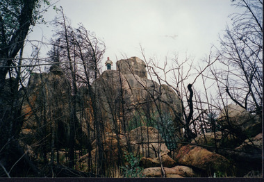
This photograph was taken in the Mount Pilot Chiltern National Park. This park is located near Chiltern in Victoria. It's most notable landmarks include Mt Pilot and Woolshed Falls. It also has many mines from the Gold Rush in the late 1800s. It is home to much flora and fauna, including the tiger quoll. The tiger quoll, also known as the spotted-tail quoll, is a marsupial that gives in the Mount Pilot Chiltern National Park. It is also main land Australia's largest carnivorous marsupial. It can weigh up too four kilograms and looks similar to either a possum or a spotted cat. It has red and brown fur with distinct spots. The tiger quoll is found along the Great Dividing Range, which includes Victoria, New South Wales and also near the border of Queensland. It lives in forests, rainforests and coastal heathlands and woodlands. In 2004 a team of volunteers from the Wooragee Landcare group as well as some of the Department of Sustainability and Environment staff set out to find the tiger quoll following the 2003 bushfires. Since the bushfires, concern had arisen for it because it hadn't been seen since the bushfires. They attempted to find traces of the quoll through finding and identifying their droppings as well as DNA testing. This photograph was taken during this search. This photograph represents the work that goes into protecting a important species like the tiger quoll. The tiger quoll is a significant species because it is main land Australia's largest carnivorous marsupial. As a result of this, there has been much work done to preserve and protect it. This photograph was taken when the Wooragee Landcare group went to ensure the survival of this species, highlighting how the tiger quoll is being protected. This photograph also demonstrates the impacts of the 2003 bushfires in the Mount Pilot Chiltern National Park. This is seen through the burnt trees featured in the picture. Landscape coloured photograph printed on gloss paperReverse: WAN NA 0ANA0N0 NNN 0 1636 / [PRINTED] (No.7) / 921quoll, mount pilot chiltern national park, national park, 2003 bushfires, search, endangered, beechworth, wooragee landcare group, wooragee landcare, wooragee, possum, australia, victoria, department of sustainability and environment, photograph, 2004, spotted-tailed quoll, great dividing range, spots, fur, forests, rainforests, woodlands, coastal heathlands, spotted quoll, spotted quoll habitat