Showing 86 items
matching ballarat aerial view
-
 Federation University Historical Collection
Image, Aerial View of Ballarat
... Aerial View of Ballarat...Lithograph of an aerial view of Ballarat.... Ballarat aerial Lithograph of an aerial view of Ballarat. Aerial ...Lithograph of an aerial view of Ballarat.ballarat, aerial -
 Federation University Historical Collection
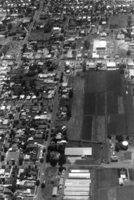
Photograph - Colour, Aerial Photograph of an area of Ballarat
Colour photograph showing an aereal view of an area of Ballarataerial, ballarat -
 Federation University Historical Collection
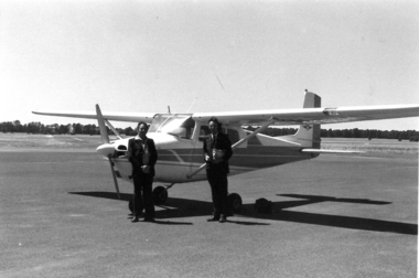
Photograph - Colour, Aeroplane at Ballarat Airport before photographing aerial views of Ballarat
... before photographing aerial views of Ballarat Photograph - Colour ...Colour photograph showing an aireal view of an area of Ballarataerial, ballarat, aeroplane, ballarat airport -
 Federation University Historical Collection
photographs and negatives, Aerial Photographs of Ballarat and Mount Helen, c1985
... of aerial views of Ballarat, Mt Helen and Mount Buninyong... photographs and 47 negative strips of aerial views of Ballarat, Mt ...Thirteen colour photographs and 47 negative strips of aerial views of Ballarat, Mt Helen and Mount Buninyongballarat, mount helen, buninyong, aerial photographs, student residences, bella guering residence, peter lalor residences, mount helen campus, camp street campus, arts academy, lake wendouree, ballarat cbd, ballarat school of mines, smb campus -
 Federation University Historical Collection
Photographs - black and white, Ballarat College of Advanced Education, Aerial views of the Mt Helen campus from the north, not dated
... campus from the north .2) Aerial view from the north Ballarat ...2 black and white aerial photographs .1) Aerial view of Mt Helen campus from the north .2) Aerial view from the northmount helen campus, mount helen campus aerial, student residences -
 Federation University Historical Collection
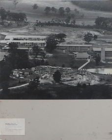
Photograph - Photograph - Black and White, Ballarat College of Advanced Education, Aerial view of the Mt Helen campus from the north, c1975
black and white photograph: Aerial view of Mt Helen campus from the north mount helen campus, mount helen campus aerial, student residences, p building, f building, g building, l building, mt helen library, union building, u building, e.j. barker library, aerial -
 Federation University Historical Collection
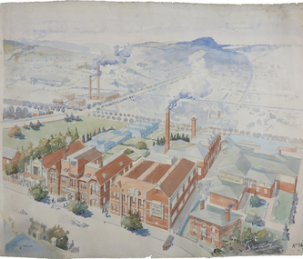
Painting - Artwork Plan, Birdseye View of the Ballarat School of Mines, 1915, 1915
Herbert Leslie (Les) COBURN (1891-1956) Australia This work was commissioned by the SMB Council to hang in its chambers. It envisions the new Junior Technical School building and was illustrated in the same year the Ballarat Technical Art School building officially opened. Les Coburn was a student at the Art School between 1908 and 1916. Coburn and his business partner, Percival Selwyn Richards (1865-1952), became joint instructors in architecture and building construction at the school from 1920, with Coburn continuing until 1948. Watercolour plan drawing on paper of Ballarat School of Mines showing the Museum, Administration building, Technical Art School, and proposed Junior Technical School, Ballarat School of Mines Botanical Gardens, and the Ballarat Gaol Governor's Residence. ballarat school of mines museum, ballarat technical art school, ballarat junior technical school, watercolour, cr. h. l. coburn, aerial, ballarat school of mines, birdseye view, h.l. coburn, herbert leslie coburn, les coburn -
 Federation University Historical Collection
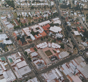
Photograph, Aerial view of the Ballarat School of Mines Lydiard Street Campus
... Aerial view of the Ballarat School of Mines Lydiard Street... Campus. Aerial view of the Ballarat School of Mines Lydiard ...Large format colour photograph of the Ballarat School of Mines Campus.smb campus, aerial photograph, aerial photograph smb, ballarat school of mines, ballarat school of mines, lydiard street south, ballarat -
 Federation University Historical Collection
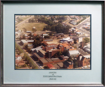
Photograph - coloured, Aerial view of SMB Lydiard Street Campus, March 1982, March 1982
SMB was established on the area on the area of the Ballarat Gaol. The Gaol has been demolished but the Brewery still stands. Hillman Recreation Centre is under construction. The tennis courts are still evident, now the site of the M B John Building.Timber frame with silver/red paint, pale blue and dark blue mount board with glass.ballarat school of mines, ballarat gaol, hillman recreation building, tennis courts, m b john, brewery -
 Federation University Historical Collection
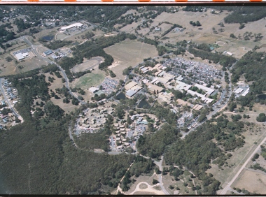
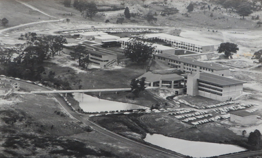
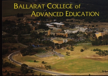
Postcard - Colour, Ballarat College of Advanced Education Aerial View, c1980, c1980
... Colour photographic postcard of an aerial view... ballarat college of advanced education mt helen campus aerial ...Colour photographic postcard of an aerial view of the Ballarat College of Advanced Education (now Federation University) campus at Mount Helen. ballarat college of advanced education, mt helen campus, aerial photograph -
 Ballaarat Mechanics' Institute (BMI Ballarat)
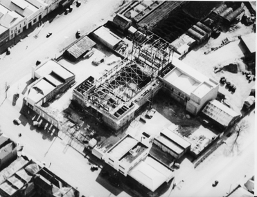
Aerial view buiding of Civic Hall 1960's
This photograph is from the Max Harris Collection held by the Ballaraat Mechanics' Institute. Please contact BMI for all print and usage inquiries.ballarat, aerial, construction, civic hall, 1960s, doveton, armstrong, mair -
 Ballaarat Mechanics' Institute (BMI Ballarat)
Aerial view of Bridge Mall & Bakery Hill, Max Harris
This photograph is from the Max Harris Collection held by the Ballaraat Mechanics' Institute. Please contact BMI for all print and usage inquiries.ballarat, bridge mall, bakery hill, 1980s, aerial -
 Ballaarat Mechanics' Institute (BMI Ballarat)
Aerial view of Bridge Mall area, Max Harris
This photograph is from the Max Harris Collection held by the Ballaraat Mechanics' Institute. Please contact BMI for all print and usage inquiries.ballarat, bridge mall, bakery hill, 1980s, aerial -
 Ballaarat Mechanics' Institute (BMI Ballarat)
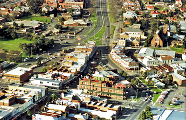
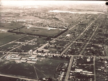
Aerial view looking south over Ballarat
... Aerial view looking south over Ballarat... aerial view above Aerial view looking south over Ballarat ...ballarat, lydiart st, sturt st, armstrong st, aerial, view, above -
 Ballaarat Mechanics' Institute (BMI Ballarat)
Aerial View
... BMI for all print and usage inquiries. ballarat aerial 1960s ...This photograph is from the Max Harris Collection held by the Ballaraat Mechanics' Institute. Please contact BMI for all print and usage inquiries.ballarat, aerial, 1960s -
 Ballaarat Mechanics' Institute (BMI Ballarat)
Aerial View Guiding Court vicinity
... BMI for all print and usage inquiries. ballarat aerial 1960s ...This photograph is from the Max Harris Collection held by the Ballaraat Mechanics' Institute. Please contact BMI for all print and usage inquiries. ballarat, aerial, 1960s -
 Ballaarat Mechanics' Institute (BMI Ballarat)
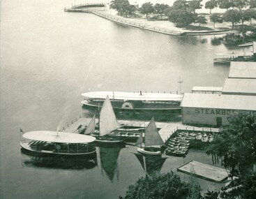
Aerial view lake and steamers
This photograph is from the Max Harris Collection held by the Ballaraat Mechanics' Institute. Please contact BMI for all print and usage inquiries.ballarat, lake wendouree, aerial, steamers -
Clunes Museum
Map - DOCUMENTS/MAP, 3 1887. .4 1891
MINING, CLUNES GOLD MINES, MAPS, SECTIONS.1 AERIAL VIEW OF CLUNES AND DISTRICT. COLOUR PHOTOGRAPH LAMINATED. .2 MAP OF MINING AREAS SHOWING EXCISED AREA. No. 9104. MINING DISTRICT OF BALLARAT. PARISH OF CLUNES. COUNTY OF TALBOT. SCALE 4 CHAINS TO AN INCH. .3 MAP OF GOLD MINING LEASE BLOCKS AT CLUNES .4 DRAWINGS OF SECTIONS, CLUNES GOLD MINES. SCALE 400 FEET TO AN NCH. ALL MOUNTED WITH PLASTIC HANGING STRIPS..1 ON BACK. CLUNES 1:25000 .2 ASSORTED HANDWITTEN NOTATIONS. .3 ASSORTED HANDWITTEN NOTATIONS. REPLACE IN DEPT. OF MINING REGISTRARS QUARTER ENDED 30TH JUNE 1887. P. 12.clunes, gold mining, leases, aerial photograph, mine sections -
 Lake Bolac & District Historical Society
Colour photograph
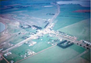
Aerial view of Lake Bolac township, looking towards the north-east, taken circa 1968. The freshwater lake is top-right, the salt-lake is centre-left. The Presbyterian church, bottom right, is surrounded by Cyprus trees on the Woorndoo/Mortlake road. The hotel and general store are opposite each other on the crossroads of the Mortlake/Ararat and Ballarat/Hamilton roads and the sporting complex is behind the store next to the salt lake. The Primary School, No 854, is between the footy oval and the Ararat Road, centre left.lake bolac, freshwater lake, salt lake, presbyterian church, hotel, general store, sporting complex, primary school, no 854. -
 Ballarat Base Hospital Trained Nurses League
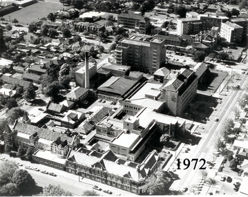
Aerial View of Ballarat Base Hospital, 1972
... Aerial View of Ballarat Base Hospital, 1972...Aerial View of Ballarat Base Hospital, 1972... Street Nth Ballarat goldfields Aerial View of Ballarat Base ...Aerial View of Ballarat Base Hospital, 1972Shows all hospital buildings including the Nurses HomePhoto - black & whitenurses, home, 1972, aerial view, ballarat, hospital -
 Ballarat Base Hospital Trained Nurses League
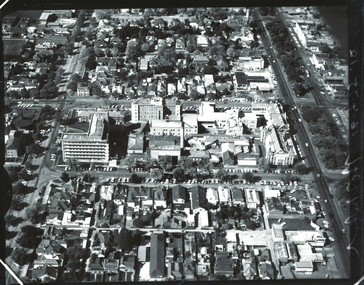
Aerial view BBH , neg Mr Harvey Photographer
... Street Nth Ballarat goldfields Aerial, view, BBH Photo Aerial ...Photoaerial, view, bbh -
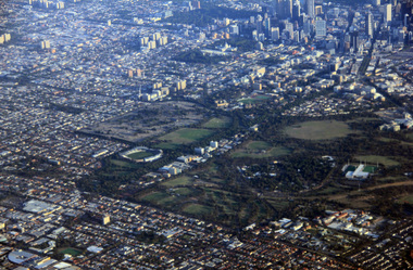
 Ballarat Heritage Services
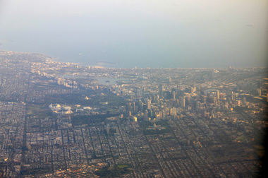
Digital Photograph, L.J. Gervasoni, Melbourne CBD and Albert Park Lake on approach Melbourne Airport, 2016
Digital Image showing an aerial view of the Melbourne Central Business District and Albert Park.aerial, melbourne, yarra river, cbd, albert park, lake, port phillip bay -
 Ballarat Heritage Services
Digital Photograph, L.J. Gervasoni, Royal Park CBD and zoo from the air, 2016
Digital Image showing an aerial view of the Melbourne Central Business District and Royal Park.aerial, melbourne, yarra river, cbd, royal park, zoo -
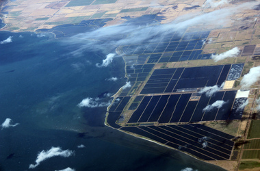 Ballarat Heritage Services
Digital Photograph, L.J. Gervasoni, werribee farm from the air, 2016
Digital Image showing an aerial view of the Melbourne Central Business District and Royal Park.aerial, melbourne, werribee farm, sewerage -
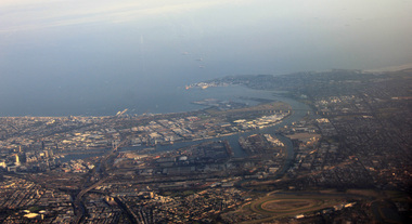 Ballarat Heritage Services
Photograph, L.J. Gervasoni, Mouth of the Yarra River from the air, 2016
Digital Image showing an aerial view of the mouth of the Yarra River from the airaerial, melbourne, mouth, yarra, river, port phillip bay, flemington, docklands, bolte bridge, west gate bridge -
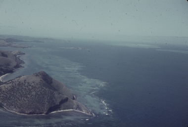 Ballarat Heritage Services
Slide, Dorothy Wickham, Port Moresby, Papua New Guinea, 1958
This photograph was taken around 1958.Scanned from a coloured slideView from this sidepapua new guinea, papuans, port moresby, aerial -
 Ballarat Heritage Services
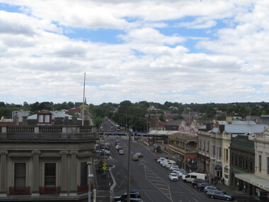
Photograph - Photograph - Colour, Ballarat From the Regent Cinema, Lydiard Street North, Ballarat, 2015, 27/12/2016
Lydiard Street is known as an axcellent example of Victorian architecture.Various views of Ballarat's Lydiard Street Northballarat, lydiard street north, buildings, aerial, birds eye, sebastions, regent cinema -
 City of Ballarat Libraries
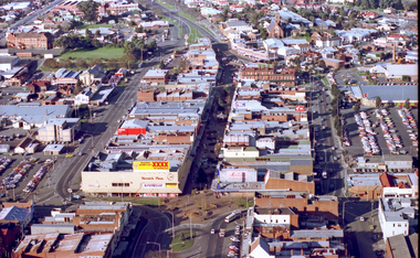
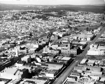
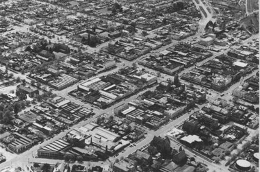
Photograph, Aerial View of the Ballarat CBD in 1957 / 1958
... Aerial View of the Ballarat CBD in 1957 / 1958....This aerial view of the Ballarat CBC was taken sometime... Ballarat East goldfields This aerial view of the Ballarat CBC ...This aerial view of the Ballarat CBC was taken sometime in 1957 or 1958. Sturt Street can be seen running from the right centre to top left.aerial view, sturt street, ballarat, central business district, cbd -
 City of Ballarat Libraries
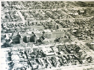
Photograph - Card Box Photographs, Queen Elizabeth Geriatric Centre, Ballarat circa 1945
... Ballarat East goldfields Aerial view of the QEGC on Ascot Street ...Aerial view of the QEGC on Ascot Street.queen elizabeth geriatric centre, qegc, ballarat, ascot street, building, public building, medical -
 City of Ballarat Libraries
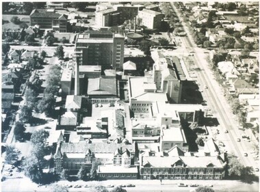
Photograph - Card Box Photographs, Ballarat Base & St John of God Hospitals, Ballarat circa 1960
... Aerial views of the Ballarat Base and St John of God... Ballarat East goldfields Aerial views of the Ballarat Base and St ...Aerial views of the Ballarat Base and St John of God Hospitals.ballarat base hospital, st john of god hospital, ballarat, drummond street noth, building, aerial view