Showing 345 items matching "basins"
-
 Mt Dandenong & District Historical Society Inc.
Photograph, Home of George Dodd at Olinda 1895, 1895
1895 picture of the home of George Dodd built c1880. Shows the Selector's Road made in the 1880s from Pig Lane in The Basin to the road in front of the Mt dandenong Hotel.The descriptive text on the reverse of this photograph was hand written by John Lundy-Clarke.1895 picture of the home of George Dodd built about 1880 showing the road the selectors made in the 1880s from Pig Lane to the main road in front of the present Mt Dandenong Hotel near the present end of the Basin-Olinda Road. It was never gazetted as a road as the Bruces objected to it and landslides in 1891 closed it temporarily and later landslides closed it permanently.george dodd, dodd, mt dandenong hotel, selector's road, road, pig lane -
 Whitehorse Historical Society Inc.
Domestic object - Basin
Very large china basin (part of a jug and basin set - jug missing) formed as a shell. Lustre pattern (cracked). Iridescent green colouring.domestic items, crockery -
 University of Melbourne, School of Chemistry
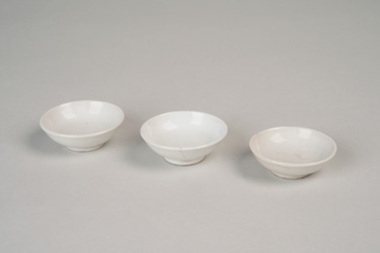
Porcelain Basins
o. 3 porcelain basins - used in these demonstrations. -
 Bendigo Historical Society Inc.
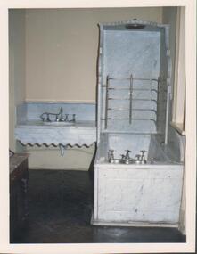
Photograph - FORTUNA COLLECTION - PHOTOGRAPH
Colour photo of an interior bathroom showing marble looking basin to the left and marble looking bath with overhead shower, silver tap fittings on basin and bath/shower. -
 Uniting Church Archives - Synod of Victoria
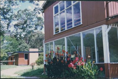
Photograph, undated
Colour photograph of the youth camp buildings at Clivedon - The Basin.youth camp, clevedon - the basin, brian walsh -
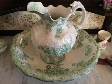 Mont De Lancey
Water jug and bowl
Johnson Brothers was a British tableware manufacturer and exporter that was noted for its early introduction of "semi-porcelain" tableware. In 2003, the manufacturing of Johnson Brothers products in Britain ceased and was transferred to China. Owned by Wandin J. Sebire Keywords White ceramic jug and basin with green floral design."Vienna" Johnson Bros. Englandjugs, water pitchers -
 Tatura Irrigation & Wartime Camps Museum
Photograph, Cattanach Canal, 1957
Taken by the photographer for Victoria State Rivers and Water Supply Commission.Large sepia photograph - water filled channel inlet and bank - Man standing on platform looking down on concrete wall of measuring weir.Above photo: "Cattanach Canal / Inlet and Measuring Weir to Waranga Basin."irrigation, victoria state rivers and water supply commission, cattanach canal -
Tatura Irrigation & Wartime Camps Museum
Photograph, Cattanach Canal, 1957
Taken by the photographer for Victoria State Rivers and Water Supply Commission.Large sepia photograph - large stretch of water in foreground, men leaning down from platform above measuring weir in middle of photograph - trees on bank left and middle distance.Above photo: "Cattanach Canal / Inlet and Measuring Weir to Waranga Basin."irrigation, victoria state rivers and water supply commission, cattanach canal, waranga basin, measuring weir -
 Flagstaff Hill Maritime Museum and Village
Wash basin
Wash basin Elfrae Made in Australia 335mm x 85mmflagstaff hill, warrnambool, shipwrecked-coast, flagstaff-hill, flagstaff-hill-maritime-museum, maritime-museum, shipwreck-coast, flagstaff-hill-maritime-village -
Tatura Irrigation & Wartime Camps Museum
Basin, 1940(Approx.)
Made by Internees at Camp 3 Tatura for washing/washing dishesMetal washing basin or dish with a small handle attached at rimcamp 3, washing, dish, tatura, internees, domestic, items, ablutions -
 National Wool Museum
Table
Shearing table. Metal and wood construction. Complete swivel basin. -
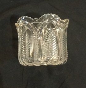 Mont De Lancey
Sugar basin, 1909
Mrs. F. WilmsCut glass sugar basin with gilt edge. Matching no. 504.sugar bowls -
Tatura Irrigation & Wartime Camps Museum
Photograph, Alan Whiting, 1924
Taken for the Victorian State Rivers and Water Supply Commission.Mounted medium sized black and white photograph. Waranga Basin inlet structure / Concrete sides mid-upper picture / channel and basin water filled / rock filled bank left of pictureirrigation, victorian state rivers and water supply commission, waranga basin -
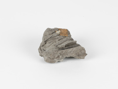 The Beechworth Burke Museum
Geological specimen - Fossiliferous Mudstone, Unknown
This specimen was found in Cape Patterson, Vic. Cape Paterson is a cape and seaside village located near the town of Wonthaggi, 132 kilometres southeast of Melbourne, in the Bass Coast Shire of Gippsland, Victoria, Australia. These dark, fossiliferous Mudstones were deposited in slow-moving water associated with sedimentary basins & continental shelves. They are rich in carbon which makes them almost black. This is typical of an anoxic, reducing environment such as deep water or stagnant conditions where carbon-rich material would remain unoxidised during subsequent deposition & diagenesis. it has an imprint of a leaf in the rock itself, displaying the fossil of the plant. This specimen is unique due to the leaf impression within the stone itself. Imprint fossils are formed from an organism moving in some way, leaving behind a trace or track. These tracks are preserved when the clay/silt dries slowly and is covered by other sediment. Plants can also leave imprint fossils when they are covered by sediment. The leaf tissue degrades, leaving an imprint of where the leaf once was. This specimen is part of a larger collection of geological and mineral specimens collected from around Australia (and some parts of the world) and donated to the Burke Museum between 1868-1880. A large percentage of these specimens were collected in Victoria as part of the Geological Survey of Victoria that begun in 1852 (in response to the Gold Rush) to study and map the geology of Victoria. Collecting geological specimens was an important part of mapping and understanding the scientific makeup of the earth. Many of these specimens were sent to research and collecting organisations across Australia, including the Burke Museum, to educate and encourage further study.These dark, fossiliferous Mudstones were deposited in slow moving water associated with sedimentary basins & continental shelves. They are rich in carbon which makes them almost black. This is typical of an anoxic, reducing environment such as deep water or stagnant conditions where carbon rich material would remain unoxidised during subsequent deposition & diagenesis. FOSSILIFEROUS MUDSTONE / Locality: Cape Patterson, Victoria | Descriptive catalogue / Pg 27 No 95 / "Grey Clay, / Cape Paterson with leaf impressions' / 15/4/21 C. William /mudstone, cape patterson, leaf imprint, fossilised leaf, fossiliferous mudstone -
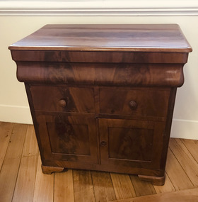 Mission to Seafarers Victoria
Furniture - Dry sink, 1800-1850
Wooden stand . top opens to reveal a basin which drains into a hole underneath.the name Volum is written at the back of the cabinetvolum collection, campaign furniture, seafaring, geelong, whaling, captain, whaler, peterhead, scotland, dry sink, wash stand, sink, james volum -
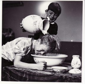 Whitehorse Historical Society Inc.
Photograph, Children at Schwerkolt Cottage
Black and white photo of children using wash basin set at Schwerkolt Cottageschwerkolt cottage -
Glenelg Shire Council Cultural Collection
Photograph - Photograph - Lee Breakwater, Portland, n.d
Port of Portland Authority ArchivesBack: PANORAMIC VIEW OF HARBOUR BASIN, PORTLAND - Pencil B 1966 - back penport of portland archives, tanker berth, k s anderson wharf, silos, marine, industry -
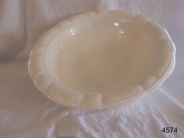
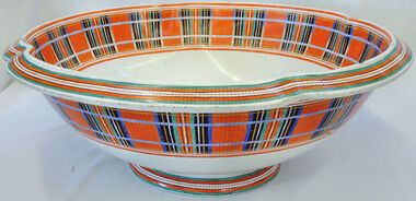 Orbost & District Historical Society
bowl, Copeland & Garrett, 1840
A bedroom set was being made by Copeland & Garrett as a wedding gift for Queen Victoria in 1840. The jug was damaged and so a new set was made. The mold and the rest of the set were destroyed so there could be no duplicates.Very large bedroom basin decorated with Royal Stuart tartan. Has a white base.Underneath - Royal Stuart - Copeland & Garrettbasin copeland-garrett -
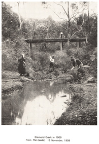 Eltham District Historical Society Inc
Work on paper (Sub-Item) - Photograph, Diamond Creek in 1909
People along the Diamond Creek, probably at Eltham with wooden bridge in backgrounddiamond creek, bridge -
 Eltham District Historical Society Inc
Work on paper (Sub-Item) - Photograph, The Kinglake escarpment. View from Bald Spur lookout across Arthurs Creek to Mount Sugarloaf, 1980
kinglake, blad spur, arthurs creek, mount sugarloaf -
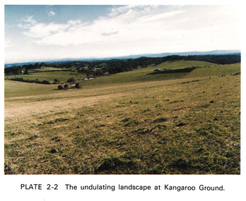 Eltham District Historical Society Inc
Work on paper (Sub-Item) - Photograph, The undulating landscape at Kangaroo Ground
kangaroo ground -
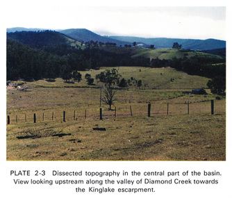 Eltham District Historical Society Inc
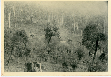
Work on paper (Sub-Item) - Photograph, Dissected topography in the central part of the Diamond Creek basin. View looking upstream along the valley of Diamond Creek towards the Kinglake escarpment
kinglake, escarpment -
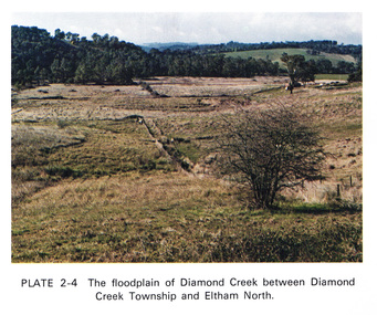 Eltham District Historical Society Inc
Work on paper (Sub-Item) - Photograph, The floodplain of Diamond Creek between Diamond Creek township and Eltham North
floodplain, eltham north -
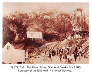 Eltham District Historical Society Inc
Work on paper (Sub-Item) - Photograph, The Union Mine, Diamond Creek circa 1900
The Union Mine operated until 1916.diamond creek, gold mine, miners, nillumbik historical society -
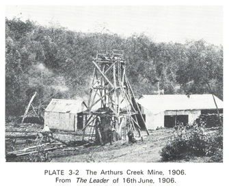 Eltham District Historical Society Inc
Work on paper (Sub-Item) - Photograph, The Arthurs Creek Mine, 1906
gold mine, arthurs creek -
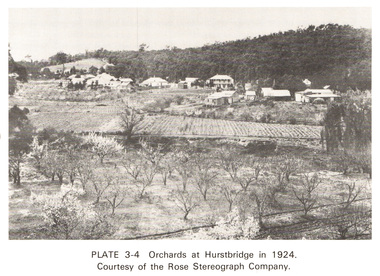 Eltham District Historical Society Inc
Work on paper (Sub-Item) - Photograph, Orchards at Hurstbridge, 1924
With the extension of the railway to Hurstbridge in 1912, large commercial orchards were able to expand. By 1914, 1,886 acres of orchards were under cultivation, with a considerable proprotion of the fruit being exported overseas. After World War One, the industry declined, mainly due to competition from other areas. This photo shows an orchard in the foreground with the township of Hurstbridge in the distance. The photo was taken in 1924, the same year that Hurstbridge was declared a township. orchard, hurstbridge, rose postcard -
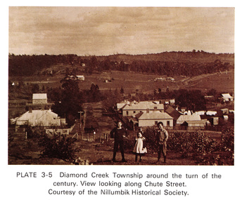 Eltham District Historical Society Inc
Work on paper (Sub-Item) - Photograph, View along Chute Street, Diamond Creek township, about 1901
diamond creek, chute street, view, nillumbik historical society -
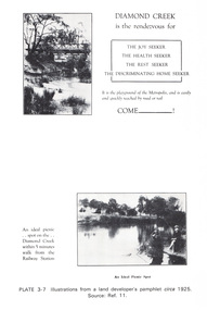 Eltham District Historical Society Inc
Work on paper (Sub-Item) - Photograph, Illustrations from a land developer's pamphlet promoting Diamond Creek, circa 1925
Photos illustrating the Diamond Creek with a bridge over it and two people sitting by the creek, one is fishing with text describing the kind of person who may like to come to the township. diamond creek, advertising, promotion, land development, real estate -
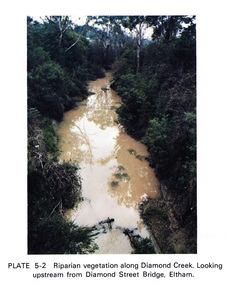 Eltham District Historical Society Inc
Work on paper (Sub-Item) - Photograph, Riparian vegetation along Diamond Creek. Looking upstream from Diamond Street Bridge, Eltham
Colour photograph of a muddy creek (probably after a downpour) with plants growing on the water's edge along both banks of the creek, including trees, shrubs, grasses and vines. eltham, creek, vegetation, diamond street, bridge, diamond creek -
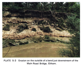 Eltham District Historical Society Inc
Work on paper (Sub-Item) - Photograph, Erosion on the outside of a bend just downstream of the Main Road Bridge, Eltham
Colour photograph of a muddy Diamond Creek (probably after a downpour) with siginificant water erosion apparent at the bend of the creek in Eltham.eltham, creek, vegetation, diamond creek, erosion