Showing 41 items
matching batman's map
-
 Melbourne Tram Museum
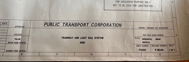
Drawing, Public Transport Corporation (PTC), Tramway and Light Rail System - P16245, 1990
Drawing shows the layout of the Melbourne tram system in 1990. Has a detail for the City area, prior to the expansion into Docklands and relocation of Batman Ave. Legend shows safety zones, loading zones, tram stops and substations, along with details of intersections, curves and crossovers.Yields detailed information about the Melbourne tram system layout in 1990.Dyeline print of drawing PTC drawing No. P16245tramways, tram stops, map, light rail, substations -
 Melbourne Tram Museum
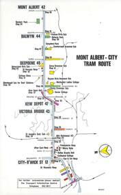
Map, Melbourne & Metropolitan Tramways Board (MMTB), Set of 15 tram route maps, 1977 to 1979
Series of 15 colour route maps for various tram lines or groups of tram lines for the MMTB. Some have the Transport Information Centre telephone printed on them, others have a label stuck on. Some are finished with a plastic laminate finish on either one or both sides. Show the major cross streets, parks, schools, other tram routes, major stop numbers and railway lines. Two copies of each held unless noted otherwise. .1 - Mont - Albert City - R11/77, shows routes 43. 47. 45. 44 .2 - Malvern, East Malvern, Carnegie and East Brighton Tram Routes (from St Kilda Junction) - R1/79 - shows routes 5, 3, 67, 66, 61, 62 and 64. .3 - Swanston St tram guide - R1/79 - lists all routes and route numbers that branch or cross Swanston St between Grattan St and St Kilda Junction. .4 - St Kilda Rd Tram Routes R12/77 - details South Melbourne Beach, route 1 and route 2 and St Kilda Beach routes 15, 16 and 55 otherwise shows were the various routes branch off St Kilda Road. Copy 1 has "P14909" in pencil in the bottom right hand corner. .5 - Kew - St Kilda Beach - R1/79 - Route 69. .6 - Footscray - Moonee Ponds - R3/81 - Route 82 .7 - Flinders St tram routes - R5/78 - North Balwyn, East Burwood, routes 48, 40, 41, Hartwell, 28, 74 and 75 .8 - William St tram routes - Route 55, 56 and 63 - South Melbourne Depot and Domain. copy 2 has "P14913" in bottom right hand corner. .9 - Toorak Camberwell and Glen Iris tram routes with Camberwell Junction and Malvern Town Hall, R1/79, routes 8, 7, 6, 72 and 73 shown. .10 - Swanston St tram routes - R12/77 - shows all the Swanston St routes, including East Coburg and Moreland. .11 - Bourke St tram routes - R4/77 - East Brunswick Blyth St and East Preston Tyler St and intermediate routes, routes 95, 96, 97, 90, 89 and 88. .12 - as for .11, dated 1/85, showing extension to La Trobe University - has Metropolitan Transit logo. Only 1 copy held. Also shows route 92 and 87. .13 - Batman Ave tram routes - R9/77 - Wattle Park, North Richmond and Prahran - routes 70, 71, 78 and 79. .14 - City route guide - R9/77 - showing all route numbers and destinations that passed through the CBD. .15 - Elizabeth St tram routes - R12/77 - Essendon Airport, West Maribyrnong, North Coburg lines, routes 50, 58, 60, 54, 57, 52. 49, 59, 18, 20 and 19. Copy 1 has "P14905" in pencil in bottom left hand corner.trams, tramways, maps, route guide, route numbers, routes, mont albert, route 43, route 47, route 45, route 44, route 42, malvern burke rd, east preston, carnegie, east brighton, south caulfield, route 5, route 3, route 67, route 62, route 64, route 66, glenhuntly tram depot, swanston st, st kilda rd, south melbourne beach, st kilda beach, route 1, route 2, route 15, route 16, route 55, kew- cotham road, route 69, route 79, route 82, footscray, moonee ponds, flinders st, north balwyn, kew, east burwood, burwood, hartwell, richmond, route 48, route 40, route 41, route 28, route 74, route 75, route 56, route 63, william st, west coburg, toorak, camberwell, glen iris, malvern town hall, route 72, route 73, route 7, route 8, bourke st, route 6, route 95, route 96, route 97, route 90, route 89, route 89, east preston, east brunswick, la trobe university, clifton hill, route 92, route 87, route 70, route 71, route 78, route 79, north richmond, prahran, wattle park, essendon airport, west maribyrnong, north coburg, route 50, route 58, route 60, route 54, route 57, route 52, route 49, route 59, route 18, route 20, route 19, batman ave -
 Melbourne Tram Museum
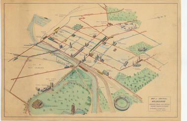
Map, Melbourne & Metropolitan Tramways Board (MMTB), "Map of Central Melbourne", c1952
Map - dyeline print then hand coloured, titled "Map of Central Melbourne", subtitled "Showing tram and bus routes, railways, places of interest:. Includes railway yards. gardens, trams routes shown in direction in some places. Has initials WKGP in bottom right hand corner. Map c1952, after the Latrobe St lines opened but before Bourke St lines opened. Note: 1 - The Hanna St or South Melbourne depot is shown south of City Road, not south of Sturt Street as it should have been. 2 - route 78 shown terminating at Batman Ave is incorrect, ran from Victoria and Church Sts. Original document scanned as a high res tiff file, approx. 60MB, see large files directory - htd3736-large.tiftrams, tramways, mmtb, map, melbourne, tram routes, south melbourne depot, hanna st depot, latrobe st, la trobe st -
 Melbourne Tram Museum
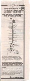
Newspaper, The Age, "New Tram route 70 Extension opens on Monday 7 June 1999 - Wattle Park to Flinders and Spencer St", 5/06/2020 12:00:00 AM
Newspaper clipping from The Age, 5/6/1999? titled "New Tram route 70 Extension opens on Monday 7 June 1999 - Wattle Park to Flinders and Spencer St". Has a map of the new service and an invite for people to attend the formal opening on 6/6/1999 by Robin Cooper, Minister for Transport. This route deviation saw the closure of the Batman Ave terminus.trams, tramways, route 70, batman ave, closure, opening, spencer st -
 Melbourne Tram Museum
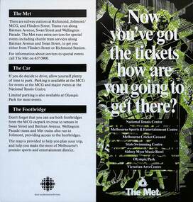
Pamphlet, The Met, "Now you've got the tickets how are you going to get there?", mid 1990s
... The Met sporting venues public transport maps Batman Ave Batman ...Pamphlet "Now you've got the tickets how are you going to get there?" published jointly by The Met and Sport and Recreation Victoria with a map of the major sporting venues in the city area and the Victorian Arts Centre. Published before the diversion of the Batman Ave tram line via Flinders St. Gives tips on parking, train/tram travel, and the MCG footbridge. The line was diverted via Flinders St on 6/6/1999 - see reference. yields information about the travelling to the major Melbourne sports venues.Pamphlet - 2 fold DL printed in colour with map.trams, tramways, the met, sporting venues, public transport, maps, batman ave, batman avenue -
 Melbourne Tram Museum
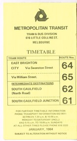
Ephemera - Timetable, Metropolitan Transit Authority (MTA), "Metropolitan Transit Timetables", Jan. 1984
Set of 13 Metropolitan Transit Tram timetables, folded sheets, 8 to 10 sections, providing timetables for specific routes, day of week giving information on tram times at specific time points, route map, sections and fares and Transport Information Centre telephone number. All printed on yellow paper. .1 - Route 64 (65 via William St), 62 and 61 - dated January 1984. .2 - Route 3 (Darling Road via Swanston St) with route 377 bus on Sundays via Batman Ave. - July 1984 .3 - Route 5 - Malvern Burke Road - City - July 1984. Cover was printed showing route 35 via William St, but has been crossed out in pencil. .4 - Route 6 (Glen Iris - City) and Route 7 (Malvern Town Hall) - July 1984. Cover was printed showing route 36 via William St, but has been crossed out in pencil. .5 - Route 8 - Toorak - City - June 1984. Cover was printed showing route 38 via William St, but has been crossed out in pencil. .6 - Route 10 and 11 West Preston via Collins St and Route 13 via Latrobe St - March 1985. .7 - Route 10 and 12 - South Melbourne and St Kilda Beach - City (Brunswick St) via Collins St and route 17 - Park and Clarendon Sts. - Sept 1984 .8 - Route 15 and 22 - Moreland to City, July 1983 .9 - Route 15, 16 and 55 - St Kilda Beach to City via Swanston St - July 1983. Cover was printed showing route 53 via William St, but has been crossed out in pencil. .10 - Route 19 (Coburg), 18 (Brunswick) and 20 (Bell St) - City - August 1984 .11 - Routes 59 (Airport West), 49 (Niddrie), 52 (Bulla Road), 51 (Essendon Station) and 81 (Essendon Depot) - April 1985. .12 - Route 69 - Kew Cotham Road to St Kilda Beach - Sept. 1984 .13 - Route 72 (Camberwell - City), 32 via William St and route 73 (Camberwell Junction) - August 1984. .14 - Route 1 and 21 - East Coburg - City - August 1983. Full Image of .10 added 9/4/17 following a query about route 19 timetables - see image i6trams, tramways, the met, timetables, melbourne, latrobe st, la trobe st, mta, buses, route 64, route 65, route 3, route 5, route 6, route 8, route 10, route 11, route 12, route 13, route 17, route 15, route 22, route 16, route 55, route 19, route 18, route 20, route 59, route 49, route 52, route 51, route 81, route 69, route 72, route 32, route 73, route 1, route 21 -
 Melbourne Tram Museum
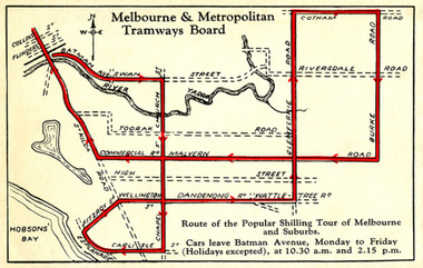
Drawing - Digital Image, Shilling Tour Map, 1927
Map shows the route of the Shilling Tour Map, using Y469 - shows the direction of travel and departure times from Batman Ave. Destination City 5th Edition notes that the services with the tram commenced in June 1927.Yields information about the MMTB's 1927 Shilling tour of Melbourne.Digital Image of an MMTB Map.trams, tramways, y class, tours, tourist trams, tourist trips, tram 191 -
 Melbourne Tram Museum
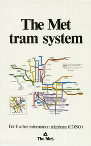
Poster, The Met, "The Met Tram System", mid 1990's
Poster - full colour on semi gloss paper titled "The Met Tram System" showing in a diagrammatic form the Melbourne tram routes, major street names, route numbers, principal suburbs, terminal names, central area (pre Docklands, post light rail to St Kilda and Port Melbourne) and ticket zones. Has The Met logo and the Public Transport Corporation names on the bottom. Mid 1990's, Batman Ave still shown. 2nd copy added 2-2-2019 and scanned, replaced image file.trams, tramways, melbourne, tramways, tram routes, map, posters -
 Melbourne Tram Museum
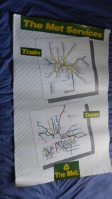
Poster, The Met, "The Met Services", mid 1990's
Poster - full colour on semi gloss paper titled "The Met Services" showing in a diagrammatic form the Melbourne tram and rail routes. For the tram section, (similar to Reg Item 509), shows major street names, route numbers, principal suburbs, terminal names, central area (pre Docklands, post light rail to St Kilda and Port Melbourne) and ticket zones. The rail map section shows the Neighbourhood ticket zones, the rail line via Altona (the direct route is not shown) and shows the St Kilda and Port Melbourne light rail lines. Has The Met logo and the Public Transport Corporation names on the bottom. Mid 1990's, Batman Ave still shown. See also Reg Items 696 and 696 for maps of the time.trams, tramways, melbourne, tramways, tram routes, railways, map, posters, tickets, neighbourhood tickets -
 Melbourne Tram Museum
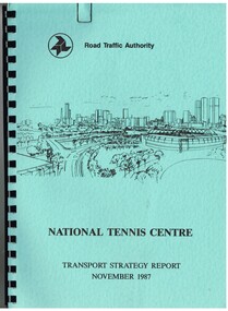
Document - Report, Dennis Johnston and Associates, Road Traffic Authority, "National Tennis Centre - Transport strategy Report November 1987", 1987
Report - 35 pages, within light blue covers, comb bound with black binder, titled "National Tennis Centre - Transport strategy Report November 1987". Report looks at the then planned Tennis Centre precinct and use of public transport in order to access it. It includes coach and car parking and how to handle various modes. Includes the MCG carpark, maps, parking areas, walking paths, access points. At the time, the tram line was located in Batman Ave. Also includes notes on the public information campaigns. Produced with the assistance of the MTA. Report prepared by Dennis Johnston and Associates for the Road Traffic Authority.trams, tramways, public transport, tennis centre, melbourne, mta -
 Melbourne Tram Museum
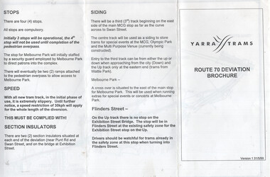
Document, Yarra Trams, "Route 70 Deviation Brochure", 5/1999
Document issued to crews at the time of the opening of the Batman Ave Deviation in June 1999. Pamphlet dated 31/5/1999. Wikipedia Reference for the route dates the use from 6/6/1999. Has a map, notes on the tram stop, speed, section insulators and the siding. Published by Yarra Trams.Demonstrates a Yarra Trams pamphlet at the time of the relocation of route 70 from the Batman Ave terminus to its operation via Flinders St and the Exhibition St bridge.Document - or pamphlet - titled "Route 70 Deviation Brochure" - A4 sheet, 3 fold DL.tramways, route 70, yarra trams, new tramways, batman ave, new track