Showing 41 items
matching bridge construction, lower plenty bridge
-
 Greensborough Historical Society
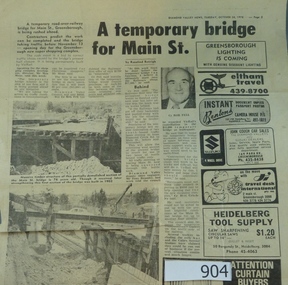
Newspaper clipping, A temporary bridge for Main Street, 24/10/1978
Leading up to the opening of Greensborough Plaza, traffic along Main Street was affected by the part closure due to the construction of a road bridge over the railway line.Significant infrastructure changes in Greensborough at the time of the opening of Greensborough Plaza in 1978.Original news clipping (Item 904) and photocopy of same (Item 958). Text and black and white images.main street greensborough, para road, railway, greensborough plaza -
 Greensborough Historical Society
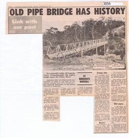
Newspaper Clipping, Diamond Valley News, Old pipe bridge has history, by Marguerite Marshall, 1891o
The aqueduct siphon bridge over the Plenty River, opened in 1891, was part of the pipeline bringing water from the service reservoir at Healesville, prior to the construction of the Maroondah Reservoir.News article, black and white text and photograph.aqueduct pipe bridge greensborough -
 Greensborough Historical Society
Report, Examining Draughtsman's Report - Watts River Aqueduct, 20/07/1897
This Field Survey was commissioned by the Melbourne Board of Works and was used to position the Maroondah Aqueduct bridge north of Greensborough at its crossing point on the Plenty River. It incorporated the use of wrought iron water pipes and therefore is of lighter construction than other similar bridges in the district. It features a traverse of the Plenty RiverThe Maroondah Aqueduct bridge is a significant example of late 19th century engineering. A 4 page reproduction of an Office of Titles document. Copy of handwritten report includes maps.maroondah aqueduct, watts river aqueduct, bridge, greensborough, office of titles, 1897, wrought iron water pipes, plenty river, melbourne board of works -
 Eltham District Historical Society Inc
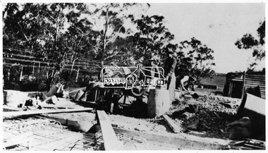
Negative - Photograph, Construction of the new concrete bridge over the Diamond Creek on Main Road, Eltham, c.May 1926
Construction of the new concrete bridge over the Diamond Creek on Main Road, Eltham, c.May 1926. Viewed from northern approach looking south east towards Eltham Park (Eltham Lower Park), showing the power lines that used to run in front of the park. The original long suspension bridge over the Diamond Creek on Main Road at Eltham collapsed during flooding of the Diamond Creek on October 13 and 14, 1923. The original bridge was built around 1840 for the coach road when Cobb & Co.'s coach was the only conveyance between Eltham and Melbourne. Widespread damage was done in Melbourne and surrounding areas by floods resulting from the overflow of the Yarra at many points along its banks. A temporary bridge rigged up was severely damaged by the flooding of the creek and was closed to vehicular traffic in April 1924. A new concrete bridge was constructed to replace it and by May 1926 all the concrete piles and abutments had been completed. The bridge was finally completed and opened for traffic in September 1926, almost three years after it initially collapsed.This photo forms part of a collection of photographs gathered by the Shire of Eltham for their centenary project book,"Pioneers and Painters: 100 years of the Shire of Eltham" by Alan Marshall (1971). The collection of over 500 images is held in partnership between Eltham District Historical Society and Yarra Plenty Regional Library (Eltham Library) and is now formally known as the 'The Shire of Eltham Pioneers Photograph Collection.' It is significant in being the first community sourced collection representing the places and people of the Shire's first one hundred years.Digital image 4 x 5 inch B&W Negshire of eltham pioneers photograph collection, bridge, bridge construction, cement mixer, diamond creek (creek), eltham, eltham lower park, eltham south, main road bridge -
 Eltham District Historical Society Inc
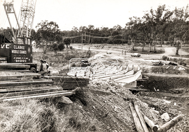
Photograph, Construction of new bridge over the Plenty River, Main Road, Lower Plenty, c.Aug. 1966
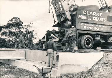
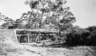
Construction of the Main Road bridge over the Plenty River. Includes structural members, construction personnel, vehicles and a Clarke mobile crane.Local significanceBlack and white printMarking on back of photograph - Plenty River Bridge Main Road 1969 (sic)lower plenty, main road, plenty river, bridge, bridge construction, civil engineering, cranes, mobile cranes -
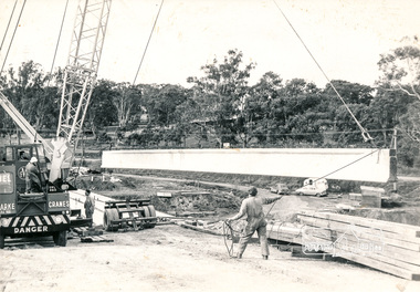 Eltham District Historical Society Inc
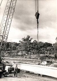
Photograph, Construction of Lower Plenty Bridge, Main Road, c.August 1966, 1966
... Construction of Lower Plenty Bridge, Main Road, c.August... melbourne plenty river bridge construction main road lower plenty ...Black and white photograph of crane lowering concrete girder into placeplenty river, bridge construction, main road, lower plenty, bridges -
 Eltham District Historical Society Inc
Photograph, Construction of Lower Plenty Bridge, Main Road, c.August 1966, 1966
... Construction of Lower Plenty Bridge, Main Road, c.August...Black and white photograph of construction of new bridge... melbourne bridge construction main road lower plenty plenty river ...Black and white photograph of construction of new bridge, Main Road, Lower Plentybridge construction, main road, lower plenty, plenty river, bridges -
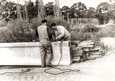
 Eltham District Historical Society Inc
Photograph, Construction of Lower Plenty Bridge, Main Road, c.August 1966, 1966
... Construction of Lower Plenty Bridge, Main Road, c.August... construction main road plenty river lower plenty bridges Black ...This black and white photograph records construction activity of the then new Main Road bridge over the Plenty River at Lower Plenty in 1969.Local significanceBlack and white photograph taken during construction of the Main Road bridge over the Plenty River. Includes structural members, construction personnel, vehicles and a Clarke mobile crane.mobile cranes, bridge construction, main road, plenty river, lower plenty, bridges -
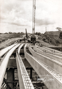
 Eltham District Historical Society Inc
Photograph, Construction of Lower Plenty Bridge, Main Road, c.August 1966, 1966
... Construction of Lower Plenty Bridge, Main Road, c.August... Lower Plenty Bridge 1969... melbourne bridges bridge construction main road lower plenty plenty ...Black and white photograph of construction of northern Lower Plenty Bridge 1969bridges, bridge construction, main road, lower plenty, plenty river, cranes -
 Eltham District Historical Society Inc
Negative - Photograph, Construction of the new concrete bridge over the Diamond Creek on Main Road, Eltham, c.May 1926
Construction of the new concrete bridge over the Diamond Creek on Main Road, Eltham, c.May 1926. Viewed from present day Wingrove Park. The original long suspension bridge over the Diamond Creek on Main Road at Eltham collapsed during flooding of the Diamond Creek on October 13 and 14, 1923. The original bridge was built around 1840 for the coach road when Cobb & Co.'s coach was the only conveyance between Eltham and Melbourne. Widespread damage was done in Melbourne and surrounding areas by floods resulting from the overflow of the Yarra at many points along its banks. A temporary bridge rigged up was severely damaged by the flooding of the creek and was closed to vehicular traffic in April 1924. A new concrete bridge was constructed to replace it and by May 1926 all the concrete piles and abutments had been completed. The bridge was finally completed and opened for traffic in September 1926, almost three years after it initially collapsed.This photo forms part of a collection of photographs gathered by the Shire of Eltham for their centenary project book,"Pioneers and Painters: 100 years of the Shire of Eltham" by Alan Marshall (1971). The collection of over 500 images is held in partnership between Eltham District Historical Society and Yarra Plenty Regional Library (Eltham Library) and is now formally known as the 'The Shire of Eltham Pioneers Photograph Collection.' It is significant in being the first community sourced collection representing the places and people of the Shire's first one hundred years.Digital image 4 x 5 inch B&W Neg Print 9 x 12.5 cmshire of eltham pioneers photograph collection, eltham, eltham lower park, main road bridge, eltham south, bridge, diamond creek (creek), wingrove park, bridge construction