Showing 4693 items
matching canterbury road estate
-
 Ringwood and District Historical Society
Pamphlet, Land Sale Brochure Titled Eureka Plan Book - Seven Delightful & Valuable Ringwood Estates - circa 1925
... ). Plan of Paradise Estate, Ringwood, includes Canterbury Road... Estate includes Pitt Street, Bedford Road, Greenwood Avenue ...Twenty page land sale brochure including photographs, subdivision features and local facilities. Additional flyer with conditions of sale and prices for estate blocks.Seven delightful and valuable Ringwood Estates called Bestpart, Paradise, Hill Top, Greenwood, Creek, Station, and School Estates. These nestle amidst the hills and valleys of beautiful Ringwood district. Also Goodluck Estate at Clarinda. Pamphlet marked as being From Mr. Farmer, No. 5 Flinders Court, Melbourne. Phone 988, 989 Central, or 55 Ringwood after 7 p.m. Plan of Ringwood School Estate includes William Street (later Kendall Street), Greenwood Avenue, Alton Street and Locke Street. Plan of Bestpart Estate, Ringwood, includes Bedford Road, Wilana Street, Greenwood Avenue, Caroline Street, Henry Street and Haig Street. Plan of Ringwood Station Estate includes Pitt Street, Bedford Road, Greenwood Avenue, Station Street, William Street (later Kendall Street, James Street, Wantirna Road, Caroline Street, Henry Street, Ellison Street and Haig Street. Plan of Geenwood Estate, Ringwood, includes Prussian Road (later Geenwood Avenue). Plan of Paradise Estate, Ringwood, includes Canterbury Road, Dandenong Road (Wantirna Road), Luck Street and Paradise Road. Plan of Creek Estate, Ringwood, includes Dandenong Creek, Wantirna Road and Gordon Crescent. Plan of Hill Top Estate, Ringwood (later Heathmont area), includes Heathmont Railway Station, Heathmont Road, Balfour Avenue, Lilian Street, Edith Street, Edna Street and Great Ryrie Street. Plan of Goodluck Estate, Clarinda, includes Talbot Avenue, Good Street, Luck Street, and Centre Road in locality plan between Oakleigh and Clayton Railway Stations. -
 Ringwood and District Historical Society
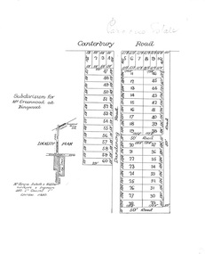
Plan, Paradise Estate Subdivision, Ringwood, Victoria - circa 1925
Paradise Estate layout also included in Land Sale Brochure Titled Eureka Plan Book - Seven Delightful & Valuable Ringwood Estates - circa 1925, Reg. No. 5100.Subdivision plan of Paradise Estate, Ringwood, showing allotments for sale, with typed page attached showing block sizes and prices.Locality plan showing land for sale south of Canterbury Road, 1 Mile south of Ringwood Railway Station. Subdivison includes Canterbury Road and Dandenong Road (later Wantirna Road). Surveyors - McKenzie Aisbett & Webber, surveyors & engineers, 440 Little Collins Street, Melbourne, Telephone Central 11540. Subdivision for Mr Grenwood at Ringwood. Additional typewritten price list showing footage, price per foot, and price per block for Lots No. 1 to 60. Paradise Estate layout also included in Land Sale Brochure Titled Eureka Plan Book - Seven Delightful & Valuable Ringwood Estates - circa 1925, Reg. No. 5100. -
 Ringwood and District Historical Society
Flyer, Stillwell & Stephens Pty. Ltd, Brochure - Multiple Properties for Public Auction at Box Hill, Ringwood, Wonga Park and Clarinda - 28th November, 1934
Seven-page brochure advertising Mortgagees' Realising Sale by Public Auction on Wednesday, 28th November, 1934 for properties at Box Hill, Ringwood, Wonga Park, and Clarinda (via Oakleigh), including photographs, property descriptions, and terms of sale.Auction Commencing at 2.15 p.m. in the Orient Line Auction Rooms, 352 Collins Street, Melbourne. Solicitors: Messrs. Madden, Butler, Elder & Graham, 406 Collins Street, Melbourne. (Agents) H.P. Knight & Co. Property Salesmen and Subidivisional Experts, 315 Collins Street, Melbourne, 'Phones: Central 10615, 10616. Attractive Residential, Orchard, and Market Garden Properties, and Public Hall and School Rooms. 1. Wonga Park via Ringwood - "Holme Bush" off Warrandyte Road, Part of Lots 14 and 15, Ringwood Orchard Estate, approximatgely three miles (north) of Ringwood Railway Station - 64 Acres. 2. 17 Bishop Street, Box Hill - timber residence. 3. Greenwood Avenue, Ringwood - On East Side, 150 feet 3 inches South of Bedford Road - timber attic residence. 4. Ringwood - Wantirna Road, South-east corner of Canterbury Road - Orchard Property of approx. 11-1/2 Acres. 5. Box Hill - Whitehorse Road, South-east corner of Linsley Street - Timber building utilised as a Public Hall and Private School. 6. Clarinda vic Oakleigh, Talbot Crescent, off Centre Road - Home on 10 acres of land. -
 Ringwood and District Historical Society
Pamphlet, G.A. Green, Auction Sale Brochure - Garden Farms Estate, Ringwood, Victoria - 1919, 1919
... ." ARMSTRONG ROAD. This new road traverses Garden Farms Estate from...." ARMSTRONG ROAD. This new road traverses Garden Farms Estate from its ...Multi-fold brochure advertising public auction of one-acre, 2-acre, 5-acre and 8-acre allotments in Ringwood and Bayswater on Saturday 12th April, 1919. Brochure includes terms of sale, description of subdivision features and local facilities, and photographic images of the area.Subdivison includes Canterbury Road Heathmont, Armstrong Road Heathmont, Armstrong Road Bayswater, Bungalook Road Heathmont, Bungalook Road Bayswater, and Orchard Road Bayswater. Road shown as Bayswater Road to Bayswater became Mountain Highway Bayswater. Vendor: H.E.B.Armstrong, Auctioneers: Coghill & Haughton, 79 Swanston Street Melbourne, Telephone Central 2793, in conjunction with J.B. McAlpin, Ringwood, Opposite Station, Telephone Ringwood 7. (Map) Woodcock & McCormack, Civil Engineers Architects & Surveyors, 430 Little Collins Street, Melbourne, Phone 3241 Central. MOST OF THE MONEY COMES OUT OF THE LAND. And more money can be obtained from anb acre of fruit than from an acre of any other produce. But you do not have to grow fruit on Garden Farms Estate. You can go in for - Outer Suburban Home - Market Garden - Orchard - Pig Raising - Poultry Farm - Small Dairy Farm - Small Fruits - Floral Culture - Scent and Bee Farm - Or just for a Week-end Home. RINGWOOD - THE PLACE TO LIVE. The Beautiful Ringwood District has so many natural attractions, that half a Land Agent's work is done in just showing a prospective buyer round and about. Ringwood has a pull of its own that attracts folk, proved beyond doubt by its rapid development within the last decade (spite the war). First, it is high and healthy, picturesque and undulating, convenient of access, sufficiently close to the Metropolis for City and Business folk to live at Ringwood. Its development is solid, because most of its people are industrious husbandmen, real producers, who have turned idle hills into smiling gardens. These are the kind of real people to live amongst; ones who wear out their spades. The rapidly-developing town has excellent Stores, Trade and Repair Shops Churches, Banks, Telephone Exchange, Weekly General Market, Cool Stores, and good Private and State Schools, etc.; is Electrically lit, has Metropolitan Water Supply, and generally provides so that practically all shopping can be done locally. WHY RINGWOOD MUST GROW. Ringwood is a great centre and must be a greater. Two rapidly-developing railways junction here. The passengers from Ringwood Station cityward, in one year, number 250,000. Ringwood will be the terminus of the Outer Suburban Electric Eastern Railway. Its natural boundaries are the River Yarra on the North, Dandenong Creek on the South, the popular town of Croydon on the East, and the suburb of Mitcham on the West. This is a large territory that is steadily being converted from intense culture, and then it might be called (as regards its gardens) "The Devon Territory of Victoria." ARMSTRONG ROAD. This new road traverses Garden Farms Estate from its northern boundary on the main Canterbury Road, across Dandenong Creek, to its southern boundary on the main Bayswater Road, and will provide a long-desired additional link of communication between Bayswater and Ringwood. The 1-acre building sites on Bayswater Road are within 8 minutes' walk of the Bayswater Railway Station, and the Canterbury Road frontages are only 1-1/2 miles from Ringwood Station, and 1/2 mile from the Railway Station site of Canterbury Road; therefore, the whole Estate is easy of access and there should be a large demand for land so favourably placed. (Image) Cultivation Field - Potatoes on Lot 28 (Image) Picture of Bayswater Creek Flats. (Image) View from "Korumbeen" where Mr. Armstrong lived on Garden Farms Estate. Estate outlined in white ring. (Image) Site of New Bridge over Dandenong Creek. (Image) On one of the timbered lots adjoining railway. (Image) This Dandenong Creek traveres the Estate. (Image) Main Fern Tree Gully Line bisects the Estate. -
 Ringwood and District Historical Society
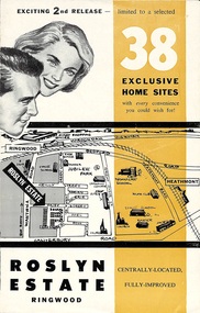
Flyer, Land Sale Brochure - Roslyn Estate, Ringwood, Vic. - circa 1960s
... Agency, 103 Canterbury Road, Heathmont. (Phone) WU7808-9.... (Agent) Heathmont Estate Agency, 103 Canterbury Road, Heathmont ...Land sale advertisement for 2nd release of residential sites with area map, layout of the estate, terms of sale, and summary of local facilities and services.Subdivision includes Daisy Street, Vale Street, Joan Court, Christine Court, and Westmore Drive. (Agent) Heathmont Estate Agency, 103 Canterbury Road, Heathmont. (Phone) WU7808-9. Brochure also includes map with streets marked as "Sold" - Reilly Street, Adrian Court, Daisy Street, Jarma Road, Joel Court, and Ross Court, with comment that "all home sites in the first release have already been sold, and most built on." -
 Ringwood and District Historical Society
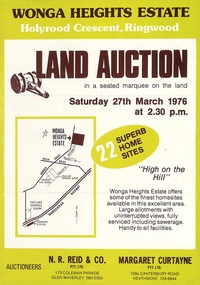
Flyer, Land Auction Advertisement - Wonga Heights Estate, North Ringwood, Victoria - 1976
Double-sided printed page advertising land auction on Saturday 27th March, 1976, with locality map and subdivision layout, terms of sale, and summary of local features and services. Subdivision includes Wonga Road, Holyrood Crescent, Georgian Court, and Stonnington Place. Auctioneers - N.R. Reid & Co. Pty. Ltd., 173 Coleman Parade, Glen Waverley (Telephone) 560 0355, and Margaret Curtayne Pty. Ltd., 109a Canterbury Road, Heathmont (Telephone) 729 6844. -
 Ringwood and District Historical Society
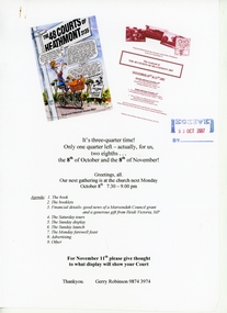
Document - Book Launch Celebration and Tour, "The 48 Courts of Heathmont"
Folder containing correspondence between book launch weekend organisers, RDHS members Gerry Robinson and Richard Carter, with details of celebrations in conjunction with tour of Reumah Court, Rawson Court, and Aringa Court on 10th & 11th November, 2007. Folder also includes RDHS newsletter dated November 2007 with report of the success of the event.Speakers include Glenda Oliver, Reumah Court resident, Greg Allen, Reumah Court resident, Lorraine Greet, Rawson Court resident, Ian McKellar, Homebush Court resident, Garry Barker, Rawson Court resident, John and Helen Munro, Aringa Court residents, Judy Normand, Aringa Court resident. Past and present memorabilia and photographic display in the Heathmont Uniting Church hall Sunday afternoon. Books ($15) and Booklets ($5) on sale both days and subsequently at Philip Webb Real Estate and Active Feet, both on Canterbury Road, Heathmont. -
 Ringwood and District Historical Society
Photograph, Image used for land sale promotion of Coleman's Heathmont Estate, looking east along Canterbury Road, Heathmont, towards Bedford Road. Sale 15/12/1923 by Public Auction
... Estate, looking east along Canterbury Road, Heathmont, towards... of Coleman's Heathmont Estate, looking east along Canterbury Road ...Written on back of photograph, "Coleman's Heathmont Estate, looking towards Bedford Rd. Sale 15/12/1923 by Public Auction". -
 Ringwood and District Historical Society
Photograph, Image used for land sale promotion of Coleman's Heathmont Estate, looking east along Canterbury Road, Heathmont. Sale 15/12/1923 by Public Auction
... Estate, looking east along Canterbury Road, Heathmont. Sale 15... Canterbury Road, Heathmont. Sale 15/12/1923 by Public Auction ...Catalogue card reads, "Coleman's Heathmont Estate - 1923. Sale 15/12/1923." -
 Ringwood and District Historical Society
Photograph, Images used for land sale promotion of Coleman's Heathmont Estate, looking across the estate from Canterbury Road, Heathmont towards Bedford Road on the far boundary. Sale 15/12/1923 by Public Auction
... Estate, looking across the estate from Canterbury Road, Heathmont... across the estate from Canterbury Road, Heathmont towards Bedford ...Catalogue card reads, "Coleman's Heathmont Estate 1923. 15/12/1923. Looking across the estate from Canterbury Rd. Bedford Rd. is seen on the far boundary." -
 Ringwood and District Historical Society
Photograph, View from Colemans Estate Heathmont, 1923. Near corner of Bedford and Canterbury Roads
... and Canterbury Roads". View from Colemans Estate Heathmont, 1923. Near ...Typed below photograph, "View from Colemans Estate Heathmont, 1923. Near corner of Bedford and Canterbury Roads". -
 Ringwood and District Historical Society
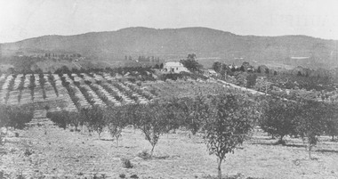
Photograph, View from Canterbury Road/Balfour Avenue area overlooking Martell's orchard, Heathmont, 1929
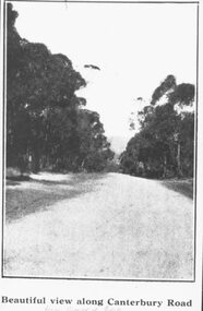
Black and white photograph of orchard. House in middle range, mountains in background. Photograph appears to be reproduced from subdivisional brochure. Note inserted in sleeve reads, "It has been pointed out that the mountains are to the east and the view is looking south. This therefore is not a 'straight' photograph. House still exists in Eden Avenue at October, 1996".(3 copies).Typed below photograph, "Panoramic view taken on the estate". "View overlooking Martell's orchard, Heathmont, 1929". Taken from corner Canterbury Rd. and Balfour Ave. looking south. Dandenong Creek just beyond house. Washusen Rd. on right". Written on back of one of the copies, "Heathmont Station Estate 1922". "Station Street, Lisgoold St. Canterbury Rd. Vivienne Cres. Balfour Ave." -
 Ringwood and District Historical Society
Photograph, Mullers orchard, Heathmont. Looking east from cnr. Canterbury and Dickasons Rds. "Charm View Estate" - 1926
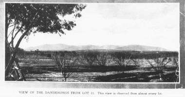
Printed below photograph, "View of the Dandenongs from Lot 11. This view is observed from almost every lot". Written on back of a photograph, "Photo taken from sub. div. plan land sales. Charm View Estate, Heathmont, 1926?" Another copy reads, "Mullers orchard, Heathmont. Taken from cnr. Canterbury and Dickasons Rds. Looking east - 1926". -
 Ringwood and District Historical Society
Photograph, Coleman's Heathmont Estate Sale, 15/12/1923. Looking west along Canterbury Road Heathmont. Railway bridge is situated at foot of hill
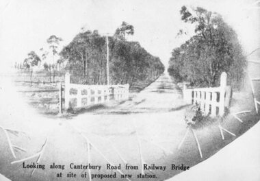
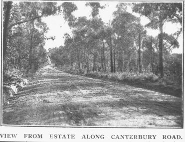
... Canterbury Road." Typed on backing sheet below, "Canterbury Rd..., "View from estate along Canterbury Road." Typed on backing sheet ...Printing below photograph reads, "View from estate along Canterbury Road." Typed on backing sheet below, "Canterbury Rd. Heathmont looking towards city. Railway bridge at foot of hill 1923. Area in foreground now shopping centre both sides of road." -
 Whitehorse Historical Society Inc.
Pamphlet - Advertising brochure, Arlington Estate
... and Canterbury Road. arlington estate blackburn molleton street ...Estate Agent's advertising brochure for Arlington Estate,Estate Agent's advertising brochure for Arlington Estate, Blackburn including Molleton Street. Baldwin Street and Canterbury Road.Estate Agent's advertising brochure for Arlington Estate,arlington estate, blackburn, molleton street, canterbury road, baldwin street, land subdivision -
 Whitehorse Historical Society Inc.
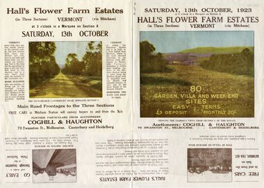
Pamphlet - Advertising brochure, Hall's Flower Farm Estates, 1923
Brochure advertising auction of 'Hall's Flower Farm Estate', Vermont 13 October 1923. 80 sites in three sections, Auctioneers; Coghill & Haughton. Colour and B & W photos.auctions, hall's flower farm estate, short street, vermont, park street, terrara road, canterbury road, view street -
 Whitehorse Historical Society Inc.
Document, Canterbury Road Tunstall, 29/01/19?5
Photocopy of letter to the Commercial Bank, Prahran re land and property valuation occupied by Mr Sliegner, north side of Canterbury Road, Tunstall (Now Forest Hill) close to Springvale Road. Land 2.5 acres with villa and out buildings.land values, sliegner (mr), canterbury road, forest hill, c. husband (estate agent) -
 Whitehorse Historical Society Inc.
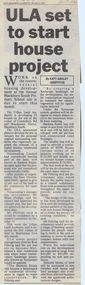
Article, ULA set to start house project, 6/10/1992 12:00:00 AM
Article on the development of 'Banksia Estate',Article on the development of 'Banksia Estate', former site of Blackburn South Primary School, Branksome Grove, by the Urban Land Authority. In Nunawading Gazette, 6 October 1992.Article on the development of 'Banksia Estate', banksia estate, victoria. urban land authority, blackburn south primary school, no. 4035, xeriscope, water supply, canterbury road, blackburn south, branksome grove, land subdivision -
 Whitehorse Historical Society Inc.
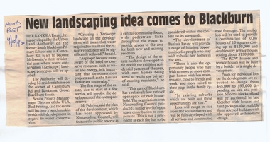
Article, New landscaping idea comes to Blackburn, 4/10/1992 12:00:00 AM
Article on the development of 'Banksia Estate',Article on the development of 'Banksia Estate', former site of the Blackburn South Primary School, Branksome Grove, by the Urban Land Authority. In Nunawading Post, 4 October 1992.Article on the development of 'Banksia Estate',banksia estate, victoria. urban land authority, blackburn south primary school, no. 4035, xeriscope, water supply, canterbury road, blackburn south, branksome grove, land subdivision -
 Whitehorse Historical Society Inc.
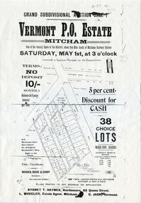
Document, Vermont P.O. Estate, 1926 0r 1915
... Mitcham melbourne auctions vermont post office estate canterbury ...Brochure advertising auction of Vermont P.O. EstateBrochure advertising auction of Vermont P.O. Estate, 38 lots, 1 May 1920. Auctioneers: Sydney T. Haynes, L. Wheeler, C. Jack.Brochure advertising auction of Vermont P.O. Estateauctions, vermont post office estate, canterbury road, vermont, boronia road, frances avenue -
 Whitehorse Historical Society Inc.
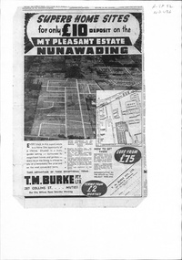
Document, Mount Pleasant Estate, ca 1953
... Mitcham melbourne land sales mount pleasant estate rooks road ...Plan and advertisements for 'Mt Pleasant Estate' Forest Hill. 381 allotments. Agent: T. M. Burke Pty Ltd.land sales, mount pleasant estate, rooks road, vermont, canterbury road, forest hill, alwyn street, mitcham, diosma crescent, nunawading, nott street, eugenia street, abelia street, weigela court, nandina street, grevillea court, azalea street, felicia grove, beech street -
 Whitehorse Historical Society Inc.
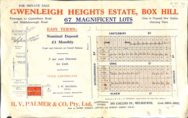
Document, Gwenleigh Heights Estate, Box Hill, unknown
Land plan of 67 allotments for sale between Canterbury Road, Middleborough Road and Agnew Street, Box Hill. (Now Blackburn South)land subdivision, middleborough road, blackburn south, canterbury road, agnew street, aberdeen road, h. v. palmer (estate agent) -
 Whitehorse Historical Society Inc.
Document, Francom's Paddock Blackburn, 1914
Auction of 80 lotsAuction of 80 lots at Francom's Paddock, BlackburnAuction of 80 lotst. r. b morton & son, francoms paddock, blackburn road, blackburn, canterbury road, south parade, main street, myrtle grove, laurel grove, laburnum street, the avenue, fuchsia street, view street, linum street, kings paddock, blackburn township estate, gardenia street -
 Whitehorse Historical Society Inc.
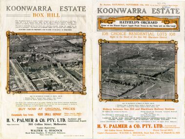
Document - Real Estate Notice, Koonwarra Estate Hatfield's Orchard, C1924
Land brochure giving details of auction of Koonwarra EstateLand brochure giving details of auction of Koonwarra Estate known as Hatfield's OrchardLand brochure giving details of auction of Koonwarra Estate land sales, koonwarra estate, hatfield's orchard, middleborough road, blackburn, canterbury road, laburnum street, hillside crescent, salisbury avenue, rymer street, pakenham street, park street, myrtle grove, h. v. palmer & co. pty. ltd., hiscock, walter g -
 Whitehorse Historical Society Inc.
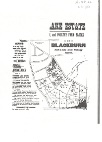
Document, Lake Estate
... avenue blackburn road lake road canterbury road Plan of Lake ...Plan of Lake Estate, Blackburn.Plan of Lake Estate, Blackburn. Poultry and farm blocks for sale. Incomplete photocopy.Plan of Lake Estate, Blackburn.auctions, lake estate, blackburn, blackburn lake sanctuary, central road, gordon crescent, wolseley crescent, wellington avenue, blackburn road, lake road, canterbury road -
 Whitehorse Historical Society Inc.
Pamphlet, Auction - Pope's Estate
Physical description Pope's Estate, Box HillPope's Estate, Box Hill subdivisional auction, 7/12/1929Physical description Pope's Estate, Box Hill duncan & weller, auctioneers, duckham street, blackburn, hirst street, middleborough road, canterbury road, amery avenue -
 Whitehorse Historical Society Inc.
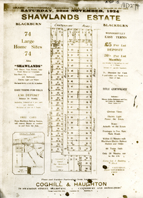
Document, Shawlands Estate, 22/11/1924 12:00:00 AM
Notice of Sale of land Holland Road and Canterbury RoadNotice of Sale of land Holland Road and Canterbury Road Blackburn Original in Haughton Maps LaTrobe LibraryNotice of Sale of land Holland Road and Canterbury Road land subdivision, canterbury road, blackburn south, holland road, shawlands avenue, coghill & haughton, shawlands estate, haughton map collection, state library of victoria. latrobe library -
Whitehorse Historical Society Inc.
Article, Carving up the Eastern Suburbs
Newspaper article about Tommy Bent and Sir Benjamin Benjamin and their land buys in the Eastern SuburbsNewspaper article about Tommy Bent and Sir Benjamin Benjamin and their land buys in the Eastern Suburbs, and the 'Queens Park Tenner' issued as a deposit for a land sale, cnr Station Street and Canterbury Roads (copy shown)Newspaper article about Tommy Bent and Sir Benjamin Benjamin and their land buys in the Eastern Suburbsland subdivision, station street, box hill, canterbury road, bent, thomas, benjamin, benjamin (sir), queens park estate, queens park tenner, freehold investment and banking company of australia ltd -
 Whitehorse Historical Society Inc.
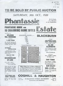
Document, Phantassie Estate, 1/10/1920 12:00:00 AM
... blackburn canterbury road bakers road phantassie estate Auction ...Auction of Phantassie House and 18 home siteAuction of Phantassie House and 18 home sites in Blackburn Saturday, 30/10/1920. Agent: Coghill & Haughton.Auction of Phantassie House and 18 home siteauctions, coghill & haughton, blackburn road, blackburn, canterbury road, bakers road, phantassie estate -
Whitehorse Historical Society Inc.
Article, A Love of yesteryear
Sale notice of a Californian bungalow in Canterbury Road Forest Hill, built by Frank Fisher, agents for Hill 60 Estate, first subdivided in 1929.Sale notice of a Californian bungalow in Canterbury Road Forest Hill, built by Frank Fisher, agents for Hill 60 Estate, first subdivided in 1929.Sale notice of a Californian bungalow in Canterbury Road Forest Hill, built by Frank Fisher, agents for Hill 60 Estate, first subdivided in 1929.californian bungalows, canterbury road, forest hill, no. 327, fisher, frank, hill 60 estate, forest hill