Showing 59 items matching "cropping area"
-
 Mt Dandenong & District Historical Society Inc.
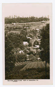
Photograph, View at Sassafras, Vic, c1930
View down the Main Street of Sassafras looking south with the Mechanics Institute in the centre of the picture. The raspberry patch in the foreground belonged to Woniger Hansen who built Mountain Rest (Rostrevor). The land was subdivided after his death in 1923. The raspberry patch is in the area of the current Mason Grove.Black and white Rose Series postcard P. 4765 looking south down the Main Street of Sassafras with buildings either side and berry patches in the foreground.On reverse POST CARD. THE "ROSE' SERIES DELUXE. A REAL PHOTOGRAPH PRODUCED IN AUSTRALIA. PUBLISHED BY 'THE ROSE STENOGRAPHS" Armadale. Victoria sassafras, rose series, rostrevor, woniger hansen, hansen, mechanics' institute, raspberry, raspberry crop, mountain rest, mason grove -
 Mt Dandenong & District Historical Society Inc.
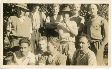
Photograph, Clint Rowse and Staff
John Lundy-Clarke grew up in the Kalorama/Mt Dandenong area and later in life (1972-74) began to write a comprehensive history of the area working from an original settlement map in an effort to cover all areas. John Lundy-Clarke has identified the photograph as being of Clint Rowse and Staff at Olinda Creek Valley in 1939. The workmen are: Back row from right: Bob Daly, Dud Page, Harry Dyson, Bill Cavell, Len Child, Ken Williams. Front row from right: Clint Rowse, Jack Clarke, Bernie Page, Jack Johnson (with dog). The Rowse family had extensive raspberry crops but later changed to flowers. Daisy Rowse married Hubert Jeeves. Black and white photograph showing a group of 10 workmen, one holding a dog.The names Lenny Child, Dyson, Page, Bob Daly, Jackie Johnston, J Clarke, Clint Rowse are handwritten on the back by John Lundy-Clarkelen child, bob daly, clint rowse, jack johnston, bill cavell, ken williams, jack clarke, dud page, bernie page -
 Mt Dandenong & District Historical Society Inc.
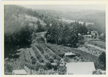
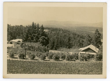
Photograph, View Over Logan's From Barber's Road
Robert Logan selected Lot 28 of the Village Settlement in 1896 and lived there until his death in 1936. Historian John Lundy-Clarke tells how Logan planted his land with plums, peaches and apples and also grew raspberries, beans, cabbages and lettuces. He also planted a small patch of oats that he harvested to feed his horse. This photograph was taken c1920 and shows the view over Logan's property of Harmony Vale, taken from Barber's Road.Black and white photograph showing lines of crops and orchard trees with rooftops in foreground and larger trees and cleared areas in background.robert logan, logan, orchard, crops, raspberries, harmony vale, barbers road -
 Mt Dandenong & District Historical Society Inc.
Photograph, View of Kalorama Gap 1905
Kalorama Gap viewed from the South West in 1908. Ellis Jeeves' 'Mountjoy' is in the centre with the stables to the left. The raspberry patch belongs to Harry Walker and the building centre right to Edward Joseph Price. John Lundy-Clarke grew up in the Kalorama/Mt Dandenong area and later in life (1972-74) began to write a comprehensive history of the area working from an original settlement map in an effort to cover all areas.Black and white photograph showing an extensive raspberry crop in the foreground with a house and outbuilding in the centre and another dwelling centre right. Handwritten description on reverse by John Lundy-Clarke. 1908 view of Kalorama Gap taken from corner of Village Settlement LOTS 2 and 3 on Ridge (then Main Road) which crosses centre of picture with Walker’s driveway dropping left. Walker’s raspberry patch in foreground. “Mountjoy” in centre of picture with coaching stables on left. Price’s house and shop on right showing large cross room used by the Village Settlers for dancing. Mrs Hand’s “Beulah Tearooms” later Mt Dandenong North Post Office is above Price’s roof.kalorama gap, kalorama, harry walker, walker, edward joseph price, raspberry, mountjoy -
 Mt Dandenong & District Historical Society Inc.
Photograph, Walker's LOT 2
Harry Walker's property would have been run by his son William in 1922. When the CRB Road cut through the property William planted plum trees on the opposite side. These are visible in this photo. An extensive raspberry crop is in the foreground. The building over the road on the left hand side is the corn and produce store built by Edward John Price (son of Edward Joseph Price) to capitalise on the CRB Road cutting through the Price farm. John Lundy-Clarke grew up in the Kalorama/Mt Dandenong area and later in life (1972-74) began to write a comprehensive history of the area working from an original settlement map in an effort to cover all areas.Small black and white postcard showing a crop in foreground with a house to the right. A road passes through the centre with a house on the left on the opposite side of the road. A view to the ranges in the distance. A handwritten description on reverse by John Lundy-Clarke.View at Kalorama. View over LOT 2 (Walkers) 1922.harry walker, william walker, crb road, raspberry, edward john price, edward joseph price, produce store, store -
 Mt Dandenong & District Historical Society Inc.
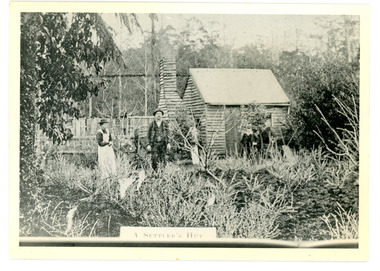
Photograph
The Keoghs took up Lot 7 in the Village Settlement in 1905. John Keogh was a big Irishman and cleared many of the giant trees on his Lot 7. They had little water for their crops so grew gooseberries and red currants rather than the more valuable strawberries. Mrs Keogh (nee Cleary) inherited money in 1906 and they built a new weatherboard house. The original bush hut remained as the kitchen. Son James (Jimmie) married Mary Walsh, a teacher at the local school. Jimmie built the small shop on the triangle of land cut off when the CRB road went through. Jimmie and his wife left the district when he joined Victoria Police. Jimmie came back to the area and finally sold the land of Lot 7 to Rimington's Nurseries. He moved his family to Kilsyth. In 1939 the shop was moved across the road to be used as an office by the road builders. It burned down that year.Black and white photograph of a man, woman and young male standing outside a wooden hut. There are crop remnants in the foreground and a wooden paling fence behind the hut. A label on the front reads A SETTLER'S HUT. Reverse of photograph has handwritten description by John Lundy-Clarke.Front: A SETTLER'S HUT Reverse: 1905 Keogh's hut on Falls Road then Main Road. This was later the kitchen of their extended home as described in the narrative "Mountain of Struggle". The figures are - Mrs Keogh. John Keogh settler. Son James Keogh.keogh, john keogh, james keogh, jimmie keogh, mary walsh, cleary, shop, store, gooseberries, rimington's nursery -
 Mt Dandenong & District Historical Society Inc.
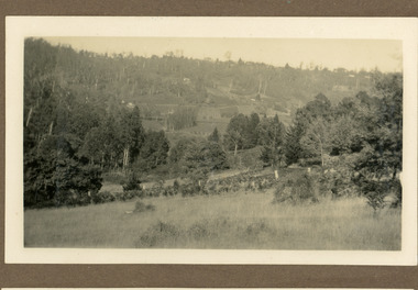
Photograph
The photograph is from the album of Ivy Child. It gives an insight into the size and make up of the settler selections in Kalorama between 1927 and 1932. Ivy May Child (1910 – 1989) was the daughter of Arthur Edward (Ted) Child (1878 – 1964) and Ethel May Madden (1888 – 1970). Ted Child was the son of Matthew Francis Child (1839 – 1933) and Martha Jeeves (1857 – 1926). He was the grandson of one of the early pioneers Francis Child. Ivy grew up on the family property on Childs Road and took many photographs. Most of these are glued into her photo album. The album covered the years from c1927 – 1932. Ivy married Henry William Burgess (1906 – 1968) in 1944. The photographs remain in their original state in the album with individual copies made. Black and white photograph looking from a flat, grassed area up a hillside. There has been significany clearing of trees with a patchwork of crops planted. A fence is visible in the foreground.ivy child, kalorama, selections -
 Mt Dandenong & District Historical Society Inc.
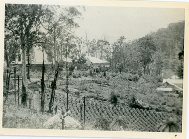
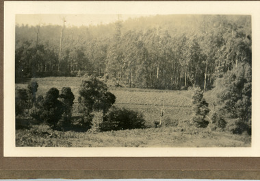
Photograph
The photograph is from the album of Ivy Child and shows a shows an area of Kalorama that has been cleared to grow crops. Ivy May Child (1910 – 1989) was the daughter of Arthur Edward (Ted) Child (1878 – 1964) and Ethel May Madden (1888 – 1970). Ted Child was the son of Matthew Francis Child (1839 – 1933) and Martha Jeeves (1857 – 1926). He was the grandson of one of the early pioneers Francis Child. Ivy grew up on the family property on Childs Road and took many photographs. Most of these are glued into her photo album. The album covered the years from c1927 – 1932. Ivy married Henry William Burgess (1906 – 1968) in 1944. The photographs remain in their original state in the album with individual copies made. Black and white photograph with bushes in the foreground, a cleared area in the centre and thick trees behind.ivy child, kalorama, crops -
 Mt Dandenong & District Historical Society Inc.
Photograph
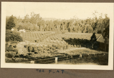
The photograph is from the album of Ivy Child. It shows a homestead with a heavily cultivated area behind. It is possibly the Child Homestead. Ivy May Child (1910 – 1989) was the daughter of Arthur Edward (Ted) Child (1878 – 1964) and Ethel May Madden (1888 – 1970). Ted Child was the son of Matthew Francis Child (1839 – 1933) and Martha Jeeves (1857 – 1926). He was the grandson of one of the early pioneers Francis Child. Ivy grew up on the family property on Childs Road and took many photographs. Most of these are glued into her photo album. The album covered the years from c1927 – 1932. Ivy married Henry William Burgess (1906 – 1968) in 1944. The photographs remain in their original state in the album with individual copies made. Sepia photograph taken in bright sunshine showing an extensively cultivated area with a wire fence in the foreground. Three buildings are seen at centre left.Handwritten below the photograph in the album" THE FLATivy child, kalorama, crops, cultivation, homestead -
 Mt Dandenong & District Historical Society Inc.
Photograph
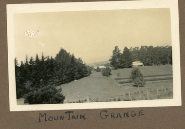
The photograph is from the album of Ivy Child. It shows a rare scene of the Mountain Grange Homestead. Mountain Grange was built by Thomas Hand on his 306 acres. By 1881 he had completed the homestead and a large barn. Thomas Hand died suddenly in 1888 and his family took over the property. His son William Hand lived in the homestead until 1931 until it was demolished due to white ants. The great barn was demolished in 1930. A new home was built and Will stayed until 1939 when the property was sold to the Shire of Lillydale. It is now the site of the Kalorama Oval. This photograph is c1927 Ivy May Child (1910 – 1989) was the daughter of Arthur Edward (Ted) Child (1878 – 1964) and Ethel May Madden (1888 – 1970). Ted Child was the son of Matthew Francis Child (1839 – 1933) and Martha Jeeves (1857 – 1926). He was the grandson of one of the early pioneers Francis Child. Ivy grew up on the family property on Childs Road and took many photographs. Most of these are glued into her photo album. The album covered the years from c1927 – 1932. Ivy married Henry William Burgess (1906 – 1968) in 1944. The photographs remain in their original state in the album with individual copies made. Black and white photograph showing a cleared area. There is a wire and posr fence in the foreground, a tall row of pine trees across the centre with two buildings visible. One in front of the trees RHS and he other in a gap in the centre. A crop has been planted in two long rows centre right of the photograph.Handwritten below the photograph in the album: MOUNTAIN GRANGEivy child, mountain grange, thomas hand, william hand, will hand, barn, great barn, homestead, shire of lillydale, kalorama oval -
 Mt Dandenong & District Historical Society Inc.
Photograph, Jeeves Coach on CRB Road at Foot of Farringdon Road Kalorama, 1920, 1920
Scene looking down Farringdon Road showing Jeeves horse drawn coach going along the CRB road (Mt Dandenong Tourist Road) in 1920. Detailed inscription on the back handwritten by John Lundy-Clarke in 1974.Jeeves Coach on CRB road at foot of Farringdon Road Kalorama (Mt Dandenong North) 1920. Road was formed most of the length from Montrose by contractors Bladin and Dick employing Robert Logan the younger, in 1919 and lay unmetalled till metalled by the contractors in 1922. Mountain ash trees in foreground were on Thomas Hand’s original 23 acre holding. Those beyond coach were on Isaac Jeeves original 160 acre holding Selection Crown Allotment 925(B). This was the area forming part of the inheritance lost by John William Richardson because of the expense of his wife’s illness. Hand enlarged his 23 acres to 305 in 1874. William and his family grew large crops of raspberries on his area, part of which is in the foreground. It had been cleared by his father’s employees before 1877. The section below the Main Road was cultivated by Fred hand, son of William and grandson of Thomas in the twenties before he moved to Redcliffes where he is today (1974). Comment by John Lundy-Clarke 10.5.1974 coach service, jeeves, crb road, farringdon road, kalorama, mt dandenong north, mt dandenong tourist road, john lundy-clarke, coach -
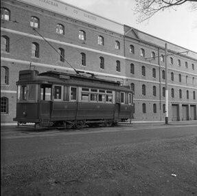
 Ballarat Tramway Museum
Photograph - Black & White Photograph/s - set of 2, State Electricity Commission of Victoria (SECV), c1950
Yields information about one of the first two maximum traction bogie trams in Ballarat in October 1945 after it had been repainted for use in Ballarat by the SEC and the Lake / depot area at the time.Black and white photograph of SEC (bogie No. 22), in Wendouree Parade passing depot junction, has destination of Victoria St. Tram later renumbered to 37 in 1951. (See Destination Eaglehawk, p7) Original of photograph, SEC held by Alan Bradley has been cropped. Had a canoe on the right hand side, which is referred to in the interpretation panel at the Gardens Loop 474.1 - shows the canoe. Additional copy of .1 added 21/3/20201,trams, tramways, ballarat, secv, bogie trams, depot junction. , tram 22, 37 -
 Ballarat Tramway Museum
Photograph - Black & White Photograph/s, John Webster, 21/08/1955 12:00:00 AM
Yields information about the appearance of one Geelong's single truck trams and its wool store environment.Black and white photograph of Geelong No. 19 with the background of the wool store area. Tram has the destination of Chilwell. Photographed by John Webster, 21/8/1955. Photo used on page 43 of Destination Eaglehawk. Actual print is part of the whole negative. See image 4210i3 On Negative in ink "EH 33" Negative scanned at hi res 4/6/2020 and image updated. ink on rear "Tram 19 Geelong Vic. W. John Webster Photo". On top edge "9263#" and EH33 21-8-55 and initials JR. In pencil is the instruction, increase to 31ems and pencil cropping marks on the rear.tramways, trams, geelong, tram 19 -
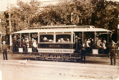 Ballarat Tramway Museum
Photograph - Black & White Photograph/s, 8/04/1903 12:00:00 AM
Black and White reproduction (copy by scanning and reprinting) of a sepia toned image of an ESCo Bendigo Electric tramcar at the time of opening trails with many people on board, crews, a dog, in the Ball Mall area. Shows details of the car decoration, painting, crew uniforms, seating arrangements, truck arrangements. Information provided with photographs says "Trial run on route to Golden Square 8.4.1903", copied from Leonard C. Bennetts collection by William Scott. Shows edges and edge damage of original photograph. Two copies held.Copy 1 - has "20)" in the top left hand and right hand corners of the front of the photograph. On the rear "140)" in ink in the top left hand corner. In pencil and ink "Bendigo Tramways (Company electric) / Trial run on route to Golden Square 8.4.1903", "copies from Leonard C. Bennetts Collection" and a "William F Scott" address label in the bottom right hand corner. copy 2- has "12" in a circle on the top left hand front. Back has been covered by a sheet of paper, but has similar notes to copy 1 and cropping instructions.trams, tramways, bendigo, pall mall, golden square, trials, esco -
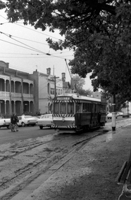 Ballarat Tramway Museum
Photograph - Digital image Set of 2, Peter Bruce, "No. 34 and schoolgirls", 1970s
Yields information about the Hospital Corner, Drummond and Sturt St intersection area.Digital image, black and white, of No. 34 at Drummond and Sturt intersection, in bound with two school girls walking across the street. The first image is a cropped version of the same photograph. Photo taken by Peter Bruce 1970's and 1971, prior to the closure of the Ballarat tramway system. Peter's Title of image: "No. 34 and schoolgirls"trams, tramways, sturt st, hospital corner, tram 34 -
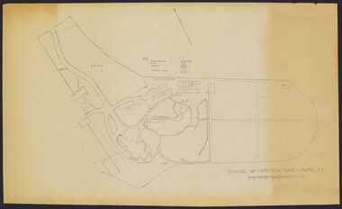 University of Melbourne, Burnley Campus Archives
Plan - Sketch, School of Horticulture - Burnley, 1957
A,B,C,E paper copies, D, tracing paper copy of plan. Hand drawn sketch of central area of grounds. Figures given for acreage of ornamentals, crops and grazing although only 1 acreage is shown on plan. (E) has further annotation. Scale 1 inch:40 ft.burnley gardens, ornmental, crops, grazing, burnley school of horticulture -
 University of Melbourne, Burnley Campus Archives
Plan, Crops Section, 1959-1983
(1) Undated photocopy, not much detail. (2) 'Crops Section 1980's', details with dates 1980-1983. (3) 'Crops Section Responsibilities 1980', labelled with initials. (4) Plans with very little detail, some areas marked, 'Plots 80-82'. (5) 'Crops Section - Burnley (1959?). (6) 'Replanting for students' Rows 6,7,8, 1crops, burnley -
 University of Melbourne, Burnley Campus Archives
Album - Black and white and colour slides, Burnley Views, 1947-1955
Contributor: T.H. KneenCardboard box of 108 35mm glass slides in metal frames made by "Gnome." Box labelled "Burnley Gardens Slides." Also 16 unused slides (1) Swan Street entrance c. (2) Orchid? b/w. (3) Nursery b/w. (4) Pasture area with man working b/w. (5) Draught horse working in the Orchard b/w. (6) Crop of corn in the Orchard c. (7) Magnolia c. (Magnolia x soulangeana). (8) Display of orange flowers c. (9) Lemon tree in the Orchard c. (10) Sign advertising 'Fruit Tree Pruning Demonstarion Sat. 2nd July (1949) c. (11) Jersey cow c. (12) Rock Point c. (13) Dahlias in the Orchard c. (14) Foundation Stone '28th August, 1946' c. (15) Felled Cypress tree 1951 b/w. (16) School truck in front of glasshouses and cacti b/w. (17)Administration Building completed but surrounded by rubble C.1949 c. (18) Plant Research Institute c. (19) Inside a glasshouse. c. (20) Administration Building c. (21) Group of female students dressed up for a function c. (22) Solenostemon (Syn. Coleus) in a glasshouse. (23, 24)Stock Matthiola incana. (25) Blossom in the Orchard c. (26) Orchard c. (27) Picking fruit in the Orchard c. (28) 2 female students holdong large bunches of poppies c. (29) Flowers growing in the Orchard c. (30) House - not Burnley c. (31) Students on an excursion c. (32) Staff member with Gladioli c. (33) Garden view - not Burnley? c. (34) Administration Building c. (35) Roses c. (36) Flowers in the Orchard c. (37) Draught horse working in the Orchard c. (38) Staff member amongst flowers in the Orchard c. (39) Garden view c. ((40) Blossom in the Orchard c. (41) Orchard c. (42) Flowers inside glasshouse c. (43) Mesembryanthemums in pots possibly in the nursery c. (44) Tree b/w. (45) Garden bed c. (46) Sign, 'Agrostology Branch, pasture Plant Research Field,' c. (47) Path to Principal's Residence c. (48) Irrigation in the Orchard b/w. (49) Cactus flowers b/w. (50) Garden view with T.H. Kneen children playing c. (51) (52) Cinerarias (now Pericallis x hybrida) in pots c. (53) Temporary building where the Grey Garden is now b/w. (54) Garden view b/w. (55) Unknown building b/w. (56) Person pruning in the Orchard c. (57) Students working in the Orchard c. (58) Swan Street with recently completed rock wall constructed by the Public Works Department b/w. (59) Lagoon paddock b/w. (60,62) Pavilion and new Administration Building before the Pavilion was removed b/w. (61) As (60) but viewed from a different direction c. (63) Plant c. (64) View through a window on the stairs in the Administration Building c. (65) Plant c. (66) Garden view of trees c. (67) Garden View b/w. (68) Blossom tree c. (69 )Garden view along path to Principal's Residence c. (70) Lagoon Paddock c. (71) Lagoon Paddock with cows b/w. (72) Inside a glasshouse b/w. (73) Entrance sign- Department of Agriculture Burnley Gardens, School of Horticulture & Primary Agriculture, Plant Research laboratory, Agrostology Branch, Fruit Preserving Branch c. (74) Plant Research Laboratory b/w. (75) Students on an excursion c. (76) Glasshouses b/w. (77) Garden view b/w. (78) Kniphophia c. (79) Hibiscus c. (80) Garden view c. (81) Dairy, Silo and dog b/w. (82) Irrigation in then Orchard b/w. (83) Garden view with magnolia c. (84) Flower plots in the Orchard c. (85) Pruning demonstration b/w. (86) Administration Building under construction c. (87) Rock Point c. (88) Mrs Kneen and Magnolia c. (89) Glasshouses c. (90) Sequoia sempervirens b/w. (91) Inside Administration Building c. (92) Luffmann Ponds b/w. (93) Sequoia sempervirend, Mrs Kneen and child c. (94) Garden bed in front of Sequoian sempervirens c. (95) Principals Residence b/w. (96) Poultry pens b/w. 1947 (97) Principals Residence b/w. (98) Student picking fruit from netted tree b/w. (99) Rock Point and Long Border c. (100) Administration Building under construction c. (101) Greenhouse b/w. (102) Rock Point c. (103) Flowers in the Orchard c. (104) Waterlilies in the Pond c. (105) Blossom tree c. (106) Hilda Kirkhope Rockery c. (107) Long Border c. (108) Plant Research Institute with flower border along drive c.burnley gardens, flower, nursery, pasture, draught horse, orchard, crops, magnolia, chicken coops, egg laying competition -
 Wodonga & District Historical Society Inc
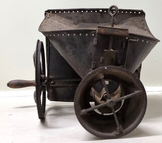
Functional object - Hand operated seed broadcaster
Seed broadcaster were used to distribute seed across a small area or to fill in patches where seeding has been missed. This method does not ensure a uniform distribution of seeds unless the person using the machine walks at a very measured pace. It also requires a lot of time and manual labour if used in larger areas. It was most used for planting cover crops, grains, grasses and similar plants that do not need to be in neat rows. The hand-crank broadcast seed spreader was invented in 1868 by Samuel S. Speicher (aka. Spyker) in Indiana, USA. By 1955 new developments included the invention of a seed broadcaster on wheels and these smaller spreaders started to disappear.This item is representative of agricultural machinery used on a local, national and international level in the late 19th and early 20th century.A metal hand seed broadcaster. A hopper at the top was the receptacle for seed. The wheel with a handle on the side when turned drives the cogs attached to an axle. This action rotates the attached spindle with blades to propel seed out the front of the broadcaster. The broadcaster would have had a shoulder strap and a bag of seed would have been added to the hopper and secured with twine through the holes around the top.agricultural tools, farm machinery -
 Woodend RSL
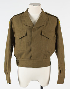
Battle Dress jacket, 1969
This battle dress jacket is dated 1969 (manufacturing date). It was issued to the “Prince of Wales’s Light Horse’ Regiment however the date of issue is unknown. A Prince of Wales Light Horse unit was based in Kyneton, a neighboring town to Woodend. This jacket likely originated from the Kyneton area. The jacket type was still in use during the Vietnam war in which the Regiment participated. Considering the condition of the item, it is highly likely the jacket has not seen active serviceThis battle dress jacket is represenative of a stamdard issue Army uniform. it is also in very good condition.Khaki, wool jacket. Prince of Wale's light horse embroidered on a yellow flash, stitched on both shoulders. Cropped style with two pockets on front, four khaki buttons and waist belt. Two epaulets and a manufacturer's label on inside left hand side. battle dress, jacket, trouser, neck tie, lanyard, khaki, wool, fabric, uniform -
 Melbourne Legacy
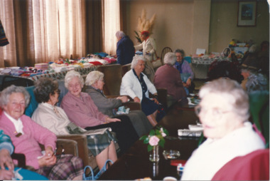
Photograph - Photo, Widows craft exhibition, 1988
... areas to crop. This paper manufactured by Kodak...." and "Crop" in black pen with lines denoting areas to crop ...Widows are sitting around chatting in the club rooms at Legacy House next to a table of craft items. This was the one of the Annual Art and Craft Exhibitions that was run by the widows club. The items could be sold at trading tables and at the table outside Legacy House during Badge Week in September to raise funds. Names unknown.A record of the type of activities Legacy provided as a social outlet for widows. Colour photo of a craft exhibition at Legacy House.Very faint "July 88" in pencil. "Legacy House Club Rooms, 293 Swanston St" and "Crop" in black pen with lines denoting areas to crop. This paper manufactured by Kodak.widows, craft, activities -
 Sunbury Family History and Heritage Society Inc.
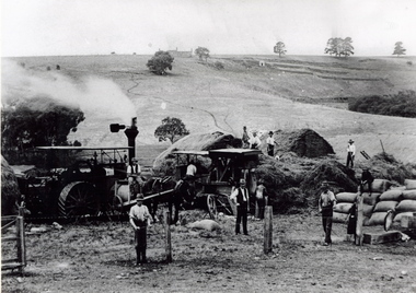
Photograph, The Nook
The photograph was taken in The Nook. Terence O'Brien rented the land from Goonawarra from the 1890s to 1905 where he grew cereal crops. The terraces on the hillside were built to grow vines when the property was one of the first vineyards in the area. The men in the image are from L-R: Mr. Heath in the white cutter owned the chaff cutter, John Leyden with hand on fence, Michael Dillon, Terence O'Brien and Phil Ratile are on top of the haystack, Andy Burke standing with hand on hip.The growing and harvesting of cereal crops was an important agricultural industry in the early days of Sunbury's settlement by both the Indigenous People and Europeans.A non-digital photograph black and white photograph of eleven men gathering hay with the aid of a steam traction engine in a wide open valley. A hillside in the distance has been terraced and there is a house on the hill in the distance.the nook, terence o'brien, andy burke, mr. heath, michael dillon, philratile, goonawarra, vineyards -
 Sunbury Family History and Heritage Society Inc.
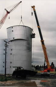
Photograph, Wheat silo, c1984
A wheat silo was erected on railway land adjacent to the Sunbury Station in 1967. Frank Millett handled the operations. As bulk handling was the preferred way to transport wheat, the silo gave local cereal growers to deliver their grain to the railhead. Over the years of the operation 200 grain wagons delivered wheat annually to the silo. In 1984 the silo was dismantled and removed.Cereal growing was one of the agricultural activities carried out in the Sunbury and surrounding areas for many years.A non-digital coloured photograph of a metal wheat silo being dismantled. A crane is beside the silo and two men are suspended from the crane in a basket to ensure that the sheets of iron land safely on the truck. wheat storage, silos, frank millett, cereal crops, sunbury railway station -
 Coal Creek Community Park & Museum
Lancet Horse Flem
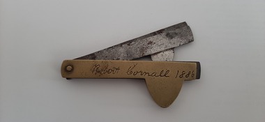
This item was the property of Mr Robert Cornall of Kardella. He was one of the first selectors in the area and the name of his property "Fleetwood" which he took possession of in 1882. He grew potatoes as his main income and was the first farmer to use fertiliser to increase his crops quantity. He died in 1924 and is buried in the Korumburra cemetery. This item is engraved with his name and name of his property. The lancet was sold by Sears and Roebuck and is seen in the 1902 catalogue. Made of brass and steel and manufactured by Joseph Rodgers and sons. The item is called a lancet but is also known as Horse Flem and was used for bleeding horses to remove bad blood. This object is of historic and scientific importance as it was used by a local potato farmer, Robert Cornall of Kardella as a bleeding tool for his horses. When purchased this item would not have been engraved. This item is engraved with the name Robert Cornell 1886 and reverse Fleetwood Gippsland Korumburra. Fleetwood was the name of his property which he settled in 1882.Bleeding of horses during this period was a way of removing bad blood.lancet -
 Mont De Lancey
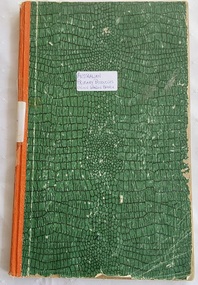
Book, Australian Primary Producers Union Wandin Branch Minute Book
This blank book was used by The Australian Primary Producers Union Wandin Branch. Minutes of the first meeting were taken Nov 20th 1947 in the Seville Hall and the last minutes were on 23.11.1954.A large green paper patterned covered Minute Book with orange tape on the spine. This blank book was used by The Australian Primary Producers Union Wandin Branch. Minutes of the first meeting were taken Nov 20th 1947 in the Seville Hall and the last minutes were on 23.11.1954. The book is filled with Minutes of meetings and has two paper insertions - a paper photopcopy of an Invoice Wandin Yallock April 30th1909. Mr Aitken for The Evelyn Preserving Co. Limited Manufacturers of Pure Jams and Jellies. Terms Cash. On the same paper The Colonial Bank of Australasia Limited stating a Sale and acknowledgement receipt of a letter and the enclosure of a remittance, signed by the manager. The second insertion is dated Sept 1950 - a Survey of cost of Production Berry Fruit Wandin Silvan Area. Youngberries. Based on Land at 100 pounds per acre and average 2 ton crop. Full details are listed.non-fictionThis blank book was used by The Australian Primary Producers Union Wandin Branch. Minutes of the first meeting were taken Nov 20th 1947 in the Seville Hall and the last minutes were on 23.11.1954. meetings, reports, proceedings, minutes of meetings -
 Eltham District Historical Society Inc
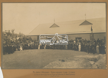
Photograph, Mr John A. Wilson's Hurstbridge Cool Store: The Official Opening by The Lord Mayor of Melbourne, Sir David Hennessy, March 20, 1915, 1915
Formal photograph taken on the occasion of the official opening. Wilson's private Cool Stores at Hurstbridge comprised six cooling chambers with a refrigeration plant to be used by local growers to store their produce. This photo was found in the Savage family home, formerly the home of Rev. Chase believed to be formerly of Panton Hill or Hurstbridge. (House may have been shifted from Panton Hill - now demolished.) Rev. Chase probably in picture, although not reported as attending in any of the newspaper reports of the day.This photo represents the significance of the orcharding industry in the Hurstbridge and surrounding area at the beginning of the twenteith century. The state of the art facility was built by private enterprise.Sepia photograph mounted on cardboard mount with printed title. Mount 55.9 x 76.0 cm. Photo 38.2 x 60.5 cm. Mount significantly damaged/broken on lower corners and slightly broken off at top left hand corner. Various other damage and chips around perimeter. Digital scan cropped from full size of mounthurstbridge, opening, celebration, orcharding -
 Bendigo Historical Society Inc.
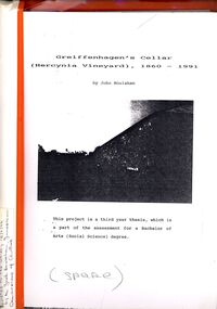
Book - STRAUCH COLLECTION: GREIFFENHAGENS CELLAR (HERCYNIA VINEYARD)
"Hercynia" was the largest vineyyard in the Bendigo District. It was started by Carl Wilhelm Greiffenhagen (William) and his cousins, twins, Carl and August Heine. The first vine cuttings were planted in 1860. The partners owned 300 acres at Axe Creek and in 1862 had 24 acres under vines and an orchard of 4 acres. By 1884 they had expanded to 30 acres of vines. They produced many award winning wines. August Heine ( 1832 - 1898) was born in Germany and came to Australia in 1854 with his twin brother Carl and their cousin William Greiffenhagen. Initially the three took up mining successfully but then the partnership bought 300 acres at Axe Creek and planted a vineyard. They also grew fruit and crops to feed the working horses. In 1870 August sold his interest in the vineyard and set up his own smaller vineyard at Sheepwash Gully. He had several business interests before he took up the caretaker position at the newly dug Weeroona lake, a position he held until his death. Carl Heine sold his interest in the vineyard in 1873 and returned to Germany. WIlliam Grieffenhagen (1834-1916) continued his very successful vineyard until the region was hit with a highly infectious vine disease in 1893. Although his own vines escaped infection, he was within the 2 mile quarantine area and was forced to dig out all his vines. He never replanted but depended on his orchard instead. He was a founding member of the Bendigo Agricultural Society and a local Shire councillor for several years. In 1870 he married Margaret Boyd.Binder containing information relating to Greiffenhagen's cellar (Hercynia Vineyard) 1860 - 1991 including black and white photographs & maps, compiled by John Houlahan as a third year thesis whichnis pat of the assessment for a Bachelor of Arts (Social Science) degree. Donated to the German Society 15/2/96 by the Grandfather of author Jack Houlahan.John Houlahanbook, bendigo, wineries, bendigo-history-axe creek- wineries- german -
University of Melbourne, Burnley Campus Archives
Book, J. E. Jessup et al, Pasture and Fodder Crops for the Murrumbidgee and Coleambally Irrigation Areas and Associated Districtsd, 1967
Book with heavy paper cover and staples. N.S.W. Dept. of Agriculture Division of Plant Industry Bulletin P248, 1967. By J. E. Jessup, Special Agronomist, Formerly District Agronomist, Leeton and D. E. Wallin, District Agronomist, Griffin.pastures, fodder crops, murrumbidgee, coleambally, irrigation, agronomy -
University of Melbourne, Burnley Campus Archives
Plan, School of Horticulture - Burnley, 1957
... Cottage, Grazing area, Ornamental, New extension, Crops... Cottage, Grazing area, Ornamental, New extension, Crops ...(1) Plan of whole site dated 22.05.1957, marked into different areas by letter with key for size of area, proposed new buildings, existing permanent and temporary buildings. New inclusion of about 1 acre hand drawn (behind Administration Building). "Burnley Areas," handwritten on reverse. (2) Handwritten notes (T.H. Kneen): Table with area, size sq ft, size acres, of Stockman's Cottage, Grazing area, Ornamental, New extension, Crops - Controlled by School (Plant Breeding, Agrostology, Biology, Egg-laying Competition) - Controlled by Other Branches. From T.H. Kneen files. On same plan as B91.0484 (original) and B91.0476.t.h. kneen, burnley gardens, burnley school of horticulture, stockmans' cottage