Showing 383 items matching "dandenong creek"
-
 Chelsea & District Historical Society Inc
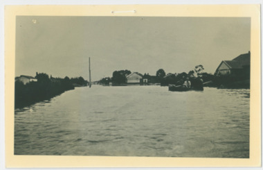
Photograph - Chelsea Flood December 1934, Men in boat delivering supplies
... Dandenong Creek..., when the Dandenong Creek and Patterson River broke their banks...., when the Dandenong Creek and Patterson River broke their banks ...In December 1934, 700 houses were inundated with water, when the Dandenong Creek and Patterson River broke their banks.Black and white photo of four men in a life boat taking supplies to houses and farmsflood, chelsea, dandenong creek, fowler street, sherwood avenue -
 Chelsea & District Historical Society Inc
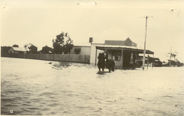
Photograph - Chelsea Flood December 1934, Corner of Sherwood Avenue and Fowler Street
... Dandenong Creek..., when the Dandenong Creek and Patterson River broke their banks...., when the Dandenong Creek and Patterson River broke their banks ...In December 1934, 700 houses were inundated with water, when the Dandenong Creek and Patterson River broke their banks.Black and white photo of water inundating a shop on the corner of Sherwood Avenue and Fowler Street, Chelsea. A person is on course back riding through the flood waters.flood, chelsea, dandenong creek, fowler street, sherwood avenue -
 Chelsea & District Historical Society Inc
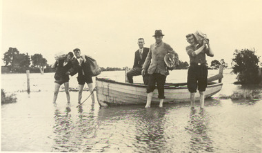
Photograph - Chelsea Flood December 1934, Delivering Food
... Dandenong Creek..., when the Dandenong Creek and Patterson River broke their banks...., when the Dandenong Creek and Patterson River broke their banks ...In December 1934, 700 houses were inundated with water, when the Dandenong Creek and Patterson River broke their banks.Black and white photo of five men in a life boat delivering rations to flood victims, landing at Wells Road. One of the men is Livock.flood, chelsea, dandenong creek, wells road -
 Whitehorse Historical Society Inc.
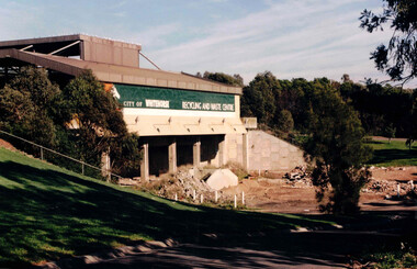
Photograph, Waste Transfer Station
... The waste centre is situated next to Dandenong Creek... Dandenong Creek... Dandenong Creek Waste Transfer Station Photograph Photograph ...The waste centre is situated next to Dandenong Creek and opposite Mahoneys Road Vermont South. Land fill was used until the 1980's when Whitehorse joined the "least Waste" program.Coloured photograph of the City of Whitehorse Recycling & Waste Centre, rear view. Situated in Vermont South near Dandenong Creekwaste transfer station, whitehorse transfer station, waste, recycling -
 Ringwood and District Historical Society
Painting, "Busch's Weir" - Oil on canvas by Hermann Otto ("Hof") Busch (1880-1960), 1953
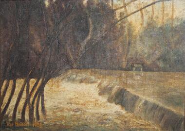
... across Dandenong Creek, forming "Busch's Weir" on his Bayswater...One of two paintings of weir across Dandenong Creek... constructed a concrete wall across Dandenong Creek, forming "Busch's ...In the 1930s, Hermann Busch constructed a concrete wall across Dandenong Creek, forming "Busch's Weir" on his Bayswater property, "Waldheim". The weir wall was demolished in the 1960s.One of two paintings of weir across Dandenong Creek, mounted in beveled edge wooden frame with ornate corner moldings. (See Reg #4856B for other of two paintings in the pair)Hof Busch 1953 -
 Ringwood and District Historical Society
Painting, "Busch's Weir" - Oil on canvas by Hermann Otto ("Hof") Busch (1880-1960), 1953
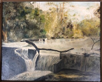
... across Dandenong Creek, forming "Busch's Weir" on his Bayswater...One of two paintings of weir across Dandenong Creek... constructed a concrete wall across Dandenong Creek, forming "Busch's ...In the 1930s, Hermann Busch constructed a concrete wall across Dandenong Creek, forming "Busch's Weir" on his Bayswater property, "Waldheim". The weir wall was demolished in the 1960s.One of two paintings of weir across Dandenong Creek, mounted in beveled edge wooden frame with ornate corner moldings. (See Reg #4856 for other of two paintings in the pair)Hof Busch 1953 -
 Whitehorse Historical Society Inc.
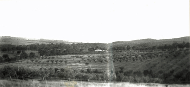
Document, Fruitgrowing in early Vermont
... dandenong creek..., the Dandenong Creek and Morack Road was a grant by Queen Victoria... Mitcham melbourne orchards boronia road vermont dandenong creek ...Handwritten information about fruit growing in Vermont from about 1880 to 1945. the area bounded by Boronia Road, the Dandenong Creek and Morack Road was a grant by Queen Victoria to an old soldier named Moore.Handwritten information about fruit growing in Vermont from about 1880 to 1945. the area bounded by Boronia Road, the Dandenong Creek and Morack Road was a grant by Queen Victoria to an old soldier named Moore. This area was subdivided about 1880. A few fruit trees planted. Later Williams Pears and Jonathan Apples were found to be best to grow. The peak of growing fruit was 1930 - 39 and steadily declined after this due to labour shortages and lack of markets during 1939 - 1945.Handwritten information about fruit growing in Vermont from about 1880 to 1945. the area bounded by Boronia Road, the Dandenong Creek and Morack Road was a grant by Queen Victoria to an old soldier named Moore. orchards, boronia road, vermont, dandenong creek, moore, isaac, morack road, vermont south -
 Ringwood and District Historical Society
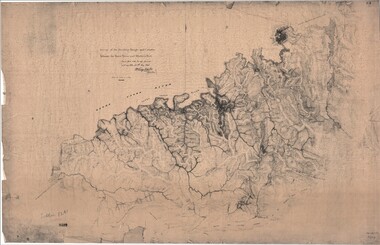
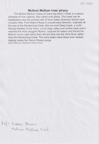
Map, Survey of Dividing Range between Yarra Yarra and Western Port - William Wedge Darke, 1843
... he made a traverse between the Mullum and Dandenong creeks..., Dandenong Creek.... which he made a traverse between the Mullum and Dandenong creeks ...Extract - Ringwood, Place of Many Eagles - Hugh Anderson (1974): William Wedge Darke, from Hereford, England, was a nephew of John Helder Wedge of the Port Phillip Association, who was also a surveyor. William's most important work was probably his survey of the Dividing Range and the country between the Yarra River and Western Port, completed in May 1843, and during which he made a traverse between the Mullum and Dandenong creeks along the higher ground that he labelled the "best line of road from Melbourne". This road was for many years the major route to Gippsland and to the higher country about Alexandra and Mansfield, sometimes known as White Horse Road, and now Maroondah Highway.Surveyor's relief map of features to the east of Melbourne including Yarra Yarra River, Mullum Mullum Creek, Anderson's Creek, Dandenong Creek.Transmitted to the Surveyor General with my letter of 10th May 1843 (signed) Wm Wedge Drake, Assistant Surveyor. Scale: two inches to a mile. Descriptive remarks include upstream area of Yarra River - "impassable, appears to have been formerly a lake", and to the south - "barren and scrubby swamps of the Western Port Country". Marked tracks include "best line of road from Melbourne", "track to Dandenong", "Road to Port Albert may probably be found on this range", "Best line to Upper Yarra". Several huts also marked. -
 Wonga Park Community Cottage History Group
Photograph (sub-item) - Black and White, Looking over the Heims’ property towards Mt. Dandenong from Jumping Creek Road in the mid 1930’s
... Looking over the Heims’ property towards Mt. Dandenong from...’ property towards Mt. Dandenong from Jumping Creek Road in the mid ... -
 Whitehorse Historical Society Inc.
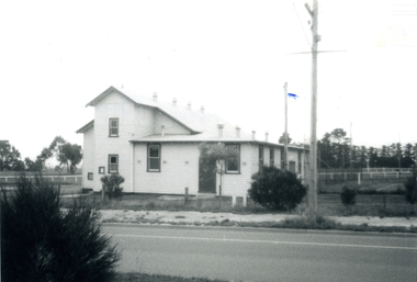
Photograph - B/W Photograph, East Burwood Public Hall East Burwood, 1971
... Dandenong Creek... of Area North of Burwood Road near Dandenong Creek East Burwood ...Black and White Photo of Area North of Burwood Road near Dandenong Creekeast burwood public hall, halls -
 Whitehorse Historical Society Inc.
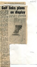
Article, Golf links plans on display, 1973
... Road and Dandenong Creek Vermont displayed at Nunawading... between Morack Road and Dandenong Creek Vermont Plans for the 145 ...Plans for the 145 acre South Vermont course between Morack Road and Dandenong Creek VermontPlans for the 145 acre South Vermont course between Morack Road and Dandenong Creek Vermont displayed at Nunawading LibraryPlans for the 145 acre South Vermont course between Morack Road and Dandenong Creek Vermontmorack golf course, south vermont -
Whitehorse Historical Society Inc.
Map, Dandenong Ranges Area, 1955
... Dandenong Creek... marked. Maps Vermont South Wantirna Dandenong Creek Sheet 13 ...Sheet 13. Parts of Parishes: Nunawading, Mulgrave and Scoresby.Sheet 13. Parts of Parishes: Nunawading, Mulgrave and Scoresby. Includes area of Vermont South marked as proposed Township of Norwich. Scale 10 chains : 1 inch. Contours marked.Sheet 13. Parts of Parishes: Nunawading, Mulgrave and Scoresby. maps, vermont south, wantirna, dandenong creek -
 Whitehorse Historical Society Inc.
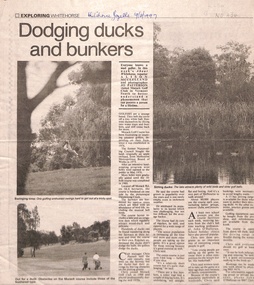
Newspaper - Article, Dodging ducks and bunkers, 19/03/1997
... dandenong creek... vermont south dandenong creek morack golf course Morack Golf ...Morack Golf Course is located off Morack Road on 56.6 hectares. It is an eighteen hole golf course opened in 1976 as a nine hole course and extended in 1980.pannell, chris, o'halloran, john, morack road, vermont south, dandenong creek, morack golf course -
 Whitehorse Historical Society Inc.
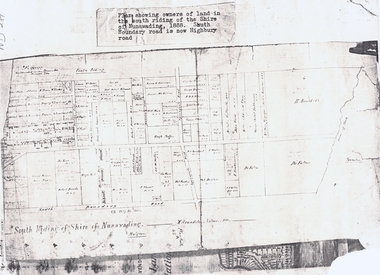
Document, South Riding
... dandenong creek... riding dandenong creek fulton dr shire of nunawading. south ...Plan showing owners of land in the South Riding of the Shire of NunawadingPlan showing owners of land in the South Riding of the Shire of Nunawading 1888. South Boundary Road is now Highbury RoadPlan showing owners of land in the South Riding of the Shire of Nunawading land subdivision, shire of nunawading. centre riding, dandenong creek, fulton, dr, shire of nunawading. south riding, arundale, w, h. arnold & co. -
Whitehorse Historical Society Inc.
Map, Subdivision of Allotment 122a, 1972
... Dandenong Creek... Vermont South Dandenong Creek Subdivision of land along Livermore ...Subdivision of land along Livermore Close and Moore Road, Vermont South.Subdivision of land along Livermore Close and Moore Road, Vermont South. Original survey Rob Poole 1899. Stamp indicates 'Land on this plan is in proclaimed survey No 21. Survey Coordination Act 1940. As from 9 Aug 1972. Two maps in different scales.Subdivision of land along Livermore Close and Moore Road, Vermont South. land subdivision, livermore close, vermont south, moore road, vermont south, dandenong creek -
 Whitehorse Historical Society Inc.
Article, Men of the Creeks, n.d
... dandenong creek... scotchman's creek bushy creek mullum mullum creek dandenong creek ...'Men of the Creeks' by R.V. Cottingham about early settlers in NunawadingPhotocopy 'Men of the Creeks' by R.V. Cottingham about early settlers in Nunawading, Boroondara, Bulleen and Mulgrave. 'Men of the Creeks' by R.V. Cottingham about early settlers in Nunawadinggardiners creek, damper creek, koonung creek, scotchman's creek, bushy creek, mullum mullum creek, dandenong creek, schwerkolt, johann august, bennett, george, william, wrighte, arundel, mcintyre, (mrs), duncan, o'leary, d, cleary, patrick -
Whitehorse Historical Society Inc.
Document, Nethercote Letter, 2010 & 2012
... Dandenong Creek... Road C 1920 and his obituary 26.3.2012. Dandenong Creek Vermont ...Transcript of letter from Viv Nethercote 2010.Transcript of letter from Viv Nethercote 2010 in reference to an old photograph of L.L. Vale Road C 1920 and his obituary 26.3.2012.Transcript of letter from Viv Nethercote 2010.dandenong creek, vermont, nethercote, viv, l.l. vale road, vermont -
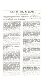
 Whitehorse Historical Society Inc.
Article, Abbey Walk Footbridge Repairs, Jan 2020
... Dandenong Creek Vermont... City of Whitehorse Dandenong Creek Vermont Abbey Walk ...Abbey Walk footbridge has been repaired.Abbey Walk footbridge has been repaired as part of the Whitehorse Council's regular maintenance program.Abbey Walk footbridge has been repaired. abbey walk vermont, footpaths, bridges, east link, city of whitehorse, dandenong creek vermont -
 Ringwood and District Historical Society
Document - Copy of Lands Department Field Notes - Ringwood, Victoria, Field Notes 76631 Surveyed in 1878
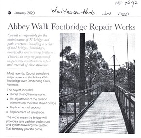
... , Dandenong Creek, Frank Miller, H.K. Kemps, Leech. Notations signed... Road, Bungalook Road, Dandenong Creek, Frank Miller, H.K. Kemps ...Foolscap size photocopy of survey map with handwritten notations. References include Canterbury Road, Bungalook Road, Dandenong Creek, Frank Miller, H.K. Kemps, Leech. Notations signed and dated January 1878 and May 1879. -
 Ringwood and District Historical Society
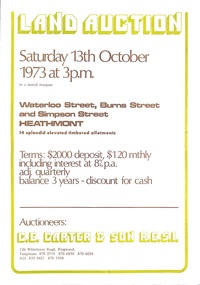
Document - Folder, Land Auction - Peacock's Estate, Waterloo Street, Heathmont, Victoria - 1973
... No. 95654 on Title (Vol 8999 Fol 058). Map shows Dandenong Creek... No. 95654 on Title (Vol 8999 Fol 058). Map shows Dandenong Creek ...Photocopy of Certificate of Title and double sided bi-fold leaflet advertising auction of 14 allotments on 13th October 1973 with map of streets, summary of local services and terms of sale. Subdivision includes Waterloo Street, Burns Road (later Dirkala Avenue), and Simpsons Road (later Simpsons Court). Auctioneers - C.E. Carter & Son R.E.S.I. 126 Whitehorse Road, Ringwood, Telephone 870 2519, 870 6830, 870 6024, A.H. 870 0421, 870 3568.Auctioneer's notation of sale prices included on brochure - all sold on day of auction. Vendor Frank Harry Peacock, Tile Burner, named as proprietor of Lot 12 on Plan of Subdivision No. 95654 on Title (Vol 8999 Fol 058). Map shows Dandenong Creek Watercourse as at September, 1971, prior to Dandenong Creek Trail development. -
 Ithacan Historical Society
Photograph, Ithacan picnic, c2000s
... Ferny Creek, Dandenong Ranges, Victoria, Australia ...The Ithacan Philanthropic Society's annual picnic has been held at various locations over the years, including Mount Evelyn, Bacchus Marsh, and in latter years at the reserve at Ferny Creek at which this photo is taken. Running races have been a highlight of the picnics. Pictured on the left are Dennis Katsamas, Anthony Drakopoulos and Greg Varigos together with the place-getters displaying their medals. The annual Ithacan Picnic has always been an important and popular social event for members and friends of the Ithacan Society. The first picnic was held in 1918. A coloured photograph of a picnic scene. -
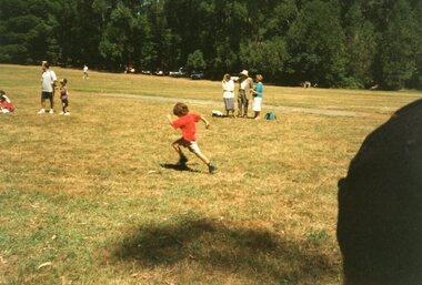 Ithacan Historical Society
Photograph, Ithacan Picnic
... Ferny Creek, Dandenong Ranges, Victoria, Australia ...The photograph was taken at one of the picnics organized by the Ithacan Philanthropic Society. The picnics have been a popular annual event on the society's calendar for many years. Over the years the picnics were held at many different venues on the outskirts of Melbourne including Mt. Evelyn and Bacchus Marsh. Of recent years Ferny Creek has been the chosen venue. The annual family picnic organized by the Ithacan Philanthropic Society is an important event in the society's calendar and allows the members to relax with family and friends in the early months of each year. A coloured photograph of a little boy dressed in a red T-shirt and running in a race at a group picnic. -
 Whitehorse Historical Society Inc.
Document, Mullum Mullum River Piracy, 2025
... Mullum Mullum Creek originally flowed into Dandenong Creek...Mullum Mullum Creek originally flowed into Dandenong Creek ...The history of Mullum Mullum CreekA4 8pnon-fictionThe history of Mullum Mullum Creekyarran dheran, mullum mullum creek -
 Mt Dandenong & District Historical Society Inc.
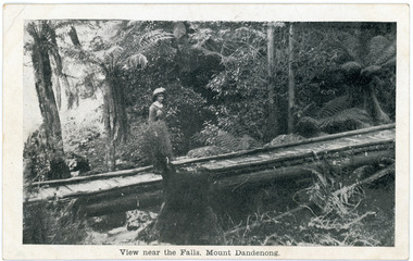
Photograph, View near the Falls, Mount Dandenong, early 1900s
... bridge Mt Dandenong Olinda Creek On front of postcard: View near ...Postcard showing a woman wearing a long dress and wide brimmed hat standing on a footbridge that crosses the Olinda Creek. Tree ferns and bushes are in the background. Taken early 1900s.On front of postcard: View near the Falls, Mount Dandenong. On back of post card: Mason, Firth & McCutcheon, Printers, Melbourne.mason, firth & mccutcheon, olinda falls, footbridge, bridge, mt dandenong, olinda creek -
 Whitehorse Historical Society Inc.
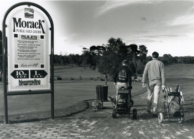
Photograph, Morack Public Golf Course, 1994
... and the Dandenong Creek.... and the Dandenong Creek. morack golf course Black and white photograph ...Morak Golf Course opened to the public on Sat. 8th May, 1976. Comprising a 9-hole course it was sited north of Burwood Road (now Burwood Highway) and between Morak Road and the Dandenong Creek.Black and white photograph of the Morak Public Golf Course, Vermont South. Large sign on left and two golfers heading out on right. 1994morack golf course -
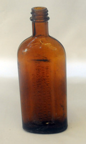 Orbost & District Historical Society
bottle, first half 20th century
... eucalyptus oil distillery, at Dandenong Creek in Victoria, followed... eucalyptus oil distillery, at Dandenong Creek in Victoria, followed ...In 1852 Bosisto opened Australia’s first commercial eucalyptus oil distillery, at Dandenong Creek in Victoria, followed by others at Emerald, Menzies Creek and Macclesfield. and began selling the oil locally. Eucalyptus oil was used as a liniment. Bosisto's bottles were generally used for eucalyptus oil. the eucalyptus oil industry was a significant early Victorian industry. Bosisto's products were commoly used in households of the first half of the 20th century. A flat-sided, brown, glass bottle with a threaded top. It has rounded shoulders.in rectangle on back - THIS BOTTLE IS AND ALWAYS REMAINS THE PROPERTY OF J. BOSISTO & COMPANTY LTD on base - F1196 M and 239 vertically -
 Ringwood and District Historical Society
Photograph, Boundary Photo across Dandenong Ck towards Ringwood (H E Parker Reserve). 1979
... . Looking across Dandenong Creek towards Ringwood (H.E. Parker..., "Jan. 79 - boundary photo. Looking across Dandenong Creek ...Written on back of photograph, "Jan. 79 - boundary photo. Looking across Dandenong Creek towards Ringwood (H.E. Parker Reserve) - ?? South East corner of Ringwood. From children's playground end of Derwent (?) St." -
Glen Eira Historical Society
Article - St Peter's Catholic Church, Bentleigh East
... Boundary Road North Road Ormond Old Dandenong Road Mordialloc Creek ...Included In The File is A Newspaper Clipping From The Age Newspaper, Dated Sat 09/11/1974 On The Opening Written By Stuart Sayers. The Article Mentions A Brief History Of The Church & School Beginnings & The Opening Ceremony. There Are Two Copies Of The Living Harvest (One Without The Cover), The Book Gives A Detailed History Of St Peter's Catholic Church, Bentleigh East Written By W.T. Dobson And Published in 1974. From The First White Settlers, The Irish Exodus, And The Irish Catholic families, The School House And The History Of The Parish & Clergy Up To 1974.st peter's catholic church, niall patrick rev, emerald hill, bentleigh east, dobson w. t., yarra, moorabbin, heriot m. b., elsternwick, north road, quinn fred, bentleigh, centre road, kennedy james joseph, melbourne south, bignell road, kennedy market garden, oakleigh, st peter's parish, st james parish, the living harvest, catholic church, hibernian society, bavarian brass band, st peter's primary school, st james regional college, brighton catholic school, brighton – st kilda mission, niall patrick william fr, dendy henry, guiney john mr, king richard, king john, keys george, o’ shanassy john, keys robert, were jonathan b., o’ connell john fr, glass hugh mr, o’ farrell peter, brady peter, kennedy james, boland michael, mccormick francis, orrong road, little brighton, oakleigh, port phillip bay, east boundary road, north road, ormond, old dandenong road, mordialloc creek, moorabbin, springvale, no good damper road, kingstown, keysborough, bignell road, south road, heatherton, big brighton, gardenvale, elsternwick, brady road, jasper road, chesterville road, cochrane road, mcguinness road, h.a.c.b.s., school house, st patrick's church, brighton parish, denominational school, little brighton school, moorabbin catholic school, temporary chapel, st james regional college, sister of mercy, lanigans ball, east brighton public hall company ltd, east bentleigh hall, messrs. robert dunn & son, bavarian brass band, st joan of arc parish, east bentleigh parish, the sisters of our lady of sacred heart, the anchor club, mccormick cornelius, cochrane james, cochrane david, mcguinness margaret, cormick john, cahill james, quinn frederick, prendegast john patrick, naughton dennis, leary william, charlston john, carey matthew fr, gibbons patrick, kennedy joseph james, o’ sullivan tim fr, mckenna fred fr, casey william fr, browne joseph fr, crawford mal fr, hanrahan mr, gillon rose miss, sampson kate mrs, horan miss, coakley daniel fr, dillon kevin fr, whitehouse ray fr, mannix daniel dr, dobson william mr, gahan patrick, hallinan thomas, delaney john, fitzgerald patrick, st peter's catholic church -
 Whitehorse Historical Society Inc.
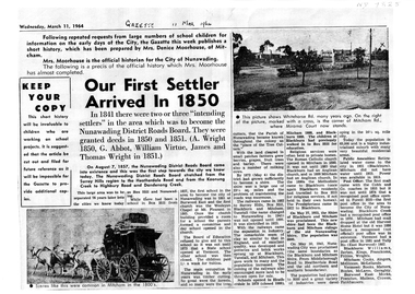
Article, Our First Settler Arrived 1850, 11/03/1964
... and Koonung Creek to Highbury Road and Dandenong Creek. This area... to Heatherdale Road and Koonung Creek to Highbury Road and Dandenong ...A4 photocopy of the history of the City of Nunawadingnon-fictionA4 photocopy of the history of the City of Nunawadingnunawading district roads board, city of nunawading -
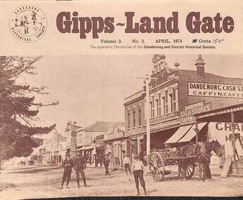 Dandenong & District Historical Society
Journal, Dandenong & District Historical Society, Gipps-Land Gate Vol.3 No.3, 1974
... Election Titbits From 1878 Dam The Dandenong Creek How Postal... The Dandenong Creek How Postal Development Grew With Dandenong Local ...An interesting group of Early Dandenong Personalities, Places and EventsA5 size publication of the Gipps-Land Gate, April 1974. 16 pages, featuring an old picture of Dandenong on the cover. Keeping Posted National Trust Records "Laurel Lodge" Centenary Of State School 1403, Dandenong Turning Back The Pages 75 Years Election Titbits From 1878 Dam The Dandenong Creek How Postal Development Grew With Dandenong Local Government 1865-1866 Roads Board Style An interesting group of Early Dandenong Personalities, Places and Eventshotel history, early education in dandenong, interesting milestones, family histories