Showing 43 items
matching dandenong show history
-
 Mt Dandenong & District Historical Society Inc.
Photograph, Robert Logan
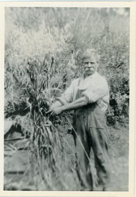
Robert Logan took up Lot 28 in the Village Settlement in 1896 and worked it until his death in 1936. His second son, Malcolm, took over the selection and continued to work it until he married and then it was subdivided. This photograph shows the oats that Robert Logan grew to feed his horse. John Lundy-Clarke grew up in the Kalorama/Mt Dandenong area and later in life (1972-74) began to write a comprehensive history of the area working from an original settlement map in an effort to cover all areas.Black and white photograph of a white haired man with a large white moustache man wearing overalls tying up a sheaf of hay. Handwritten description on reverse by John Lundy-Clarke.Robert Logan with hay grown on LOT 28 SECTION 1 of the Village Settlement. He was the original selector and his LOT was the last worked fully (by his son Malcolm) in SECTION 1. 1920. robert logan, logan, malcolm logan, kalorama, john lundy-clarke -
 Mt Dandenong & District Historical Society Inc.
Photograph, Farringdon Road
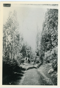
Mt Dandenong Road (CRB Road, New Road, Main Road) was begun in the early 1920s and completed c1926. This would be a very early photograph in the history of the road and shows a Jeeves coach travelling along the new road at the base of Farringdon Road in Kalorama. Ellis Jeeves established the coach sevice between Kalorama and Croydon in 1904. It originally travelled down the Old Coach Road. John Lundy-Clarke grew up in the Kalorama/Mt Dandenong area and later in life (1972-74) began to write a comprehensive history of the area working from an original settlement map in an effort to cover all areas.Black and white photograph looking down an unmade road showing a coach travelling along another unmade road at the bottom. Roads are tree lined. handwritten inscription on reverse by John Lundy-Clarke.1920 Farringdon Road, looking at Jeeves Coach on Mt Dandenong Road.mt dandenong road, crb road, farringdon road, jeeves, ellis jeeves, coach, mt dandenong tourist road, kalorama -
 Mt Dandenong & District Historical Society Inc.
Photograph, Home and Shop of Edward Joseph Price
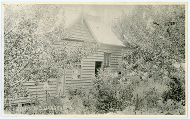
John Lundy-Clarke grew up in the Kalorama/Mt Dandenong area and later in life (1972-74) began to write a comprehensive history of the district working from an original settlement map in an effort to cover all areas. Edward Joseph Price was the first settler to take up a lot (Lot 1, Section 1) in the Village Settlement. He built a slab hut and brought up his family in 1896. This photograph shows a newer home built in 1908. It had a section used as a shop and also had a large room built that was to be used for public gatherings. Health department regulations led to this being impossible. The house faced Ridge Road.Black and white close up photograph showing a building made from wooden boards with trees in the front. Reverse of photograph has handwritten description by John Lundy-Clarke.On Front STORE MT DANDENONG On Reverse Home and Shop of Edward Joseph Price LOT 1 SECT 1 erected in 1908 on site of earlier dwelling from which goods had been sold without a special room for shop. In picture the room on the extreme left was bedroom for boys Charlie and Ted (Edward John). Under the gable was a large room planned for public use but never used owing to Health Department Regulations. The narrow door (open) and window were the shop which was the district’s first newsagency. Window behind leaves at right was the kitchen. 1908-1912. Gabled portion is now part of home “Mirra Laken” 1975edward joseph price, store, shop -
 Mt Dandenong & District Historical Society Inc.
Photograph
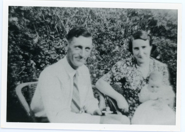
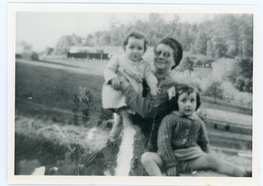
The Wenborn family acquired Ferguson's Lot 19 of the Village Settlement where the original Mount Dandenong School was opened in a shed. WH Collom owned the land after Ferguson and then it passes to the Wenborns. This photograph shows Jim Wenborn with his wife Ivy and daughter Mary. The Wenborns had another daughter, Joan. Both children attended Mt Dandenong State School. John Lundy-Clarke grew up in the Kalorama/Mt Dandenong area and later in life (1972-74) began to write a comprehensive history of the area working from an original settlement map in an effort to cover all areas.Black and white photograph showing a man and woman seated in a garden. The woman is holding a small baby. Handwritten inscription on reverse by John Lundy-ClarkeJim Wenborn and family.wenborn, jim wenborn, ivy wenborn, mary wenborn, joan wenborn, ferguson, wh collom, mt dandenong school -
 Mt Dandenong & District Historical Society Inc.
Photograph
The Wenborn family acquired Ferguson's Lot 19 of the Village Settlement where the original Mount Dandenong School was opened in a shed. WH Collom owned the land after Ferguson and then it passes to the Wenborns. This photograph, taken c1942, shows Ivy Wenborn with her daughters Mary and Joan. John Lundy-Clarke grew up in the Kalorama/Mt Dandenong area and later in life (1972-74) began to write a comprehensive history of the area working from an original settlement map in an effort to cover all areas.Black and white photograph of a woman nursing a young girl Another young girl is seated at her right.Behind is a view of trees and a house. Handwritten inscription on reverse by John Lundy-ClarkeWenborn Family. Looking across what is now Kalorama Park showing Norman Jeeves' house behind the hedge to the left of the child.wenborn, ivy wenborn, mary wenborn, joan wenborn, norman jeeves, kalorama park, jeeves -
 Mt Dandenong & District Historical Society Inc.
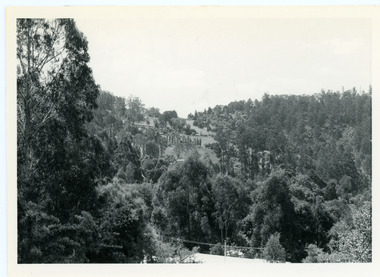
Photograph, View From Doughty's Road 1974
John Lundy-Clarke grew up in the Kalorama/Mt Dandenong area and later in life (1972-74) began to write a comprehensive history of the area working from an original settlement map in an effort to cover all areas. This photograph shows approximately the same area as photograph number KAL0193 but is taken 60 years later. The trees have grown much taller and the buildings changed. On the site of the Paynter house 'Iona' there is now the 'Yosemite' (Villa Toscana) accommodation. The pavilion in the centre of the photo is the site of 'Kalorama', home of early pioneer Isaac Jeeves. The photograph is taken looking up towards The Gap (FiveWays).Black and white photograph showing a forested area with clear sites. Roofs of buildings can be clearly seen. Handwritten inscription on reverse by John Lundy-ClarkeView from near Doughty’s Rd looking north up valley to Kalorama Gap in Jan 1973. Tiny roof in centre is pavilion on site of “Kalorama”. Long roof to its left is Yosemite Motel on site of “Iona”.paynter, kalorama, iona, yosemite, villa toscana, five ways, the gap -
 Mt Dandenong & District Historical Society Inc.
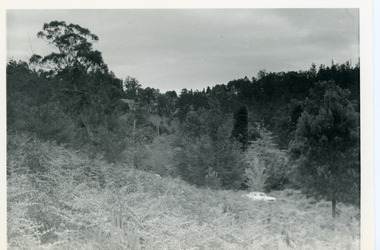
Photograph, View Up Valley Towards Kalorama Gap 1973
John Lundy-Clarke grew up in the Kalorama/Mt Dandenong area and later in life (1972-74) began to write a comprehensive history of the area working from an original settlement map in an effort to cover all areas. This photograph would have been taken to show the changes in the area over the years. Kalorama Gap is now called Five Ways. 'Kia-Ora ' was a guest house built by George Barber. It is no longer standing.Black and white photograph showing a bush scene with a white car visible on the right. Handwritten inscription on reverse by John Lundy-Clarke1973 View up Valley towards Kalorama Gap from what was Crooks LOT 24. White car is on Barbers Road and site of “Kia Ora” is to right of it.kalorama, kalorama gap, five ways, barbers road, george barber, kia-ora -
 Southern Sherbrooke Historical Society Inc.
Information folder - Glen Park
Folder containing information pertaining to the history of Glen Park homestead, Menzies Creek. Contents: -two pages photocopied from "That Little Train" by Peter Cuffley, showing four photos of Glen Park homestead and a short history of Edwin Johns at Glen Park (2 copies of each) -articles, "No. 861's full steam ahead again", photo shows Col Rees with Coonara Community School students, and "Living the dream" re. engine no. 861. On verso, "A Family Reunited", article by Emerald Tourist Railway re. locomotives, and "Colin just loves steam locomotion" re. engine no. 861. -4 letters, from Puffing Billy Railway, in support of Col Rees. -Letter, dated 19 June 1996, from Emerald Tourist Railway, re. appeal for restoration of Garratt engine. On verso, copy of certificate awarded to Col Rees for donation to appeal. -Letter, 1 June 1998, re. Garrett appeal. On verso, certificate awarded to Col & Kellie Rees for donation to appeal. -Aerial photo showing proposed property boundaries of Glen Park subdivision. -Aerial photo showing existing property boundaries of Glen Park. NB. last four items provided to society by Col Rees in support of subdivision. -Memorandum dated 2 May 2000 from Graham Whitt, Shire of Yarra Ranges, to Shire Service Centres, re proposed division of Glen Park land. -Fax, dated 13 June 2000, from Southern Sherbrooke Historical Society to Shire of Yarra Ranges, re. intention to make submission. -Letter, dated 14 June 2000, acknowledging receipt of above fax. -Submission, dated 18 June 2000, from Southern Sherbrooke HS, expressing concern re. proposed subdivision of Glen Park. -Fax, dated 27 June 2000, from Dianne Kueffer to Susan Heywood-Downard, Agenda Item 2 of the Yarra Ranges Planning Committee Agenda 14 March 2000, including detailed description of proposed subdivision and map. -Letter, dated 7 July 2000, Shire to Society, re. discussion of Glen Park subdivision by council. -Letter, dated 7 July 2000, Society to Shire, re. withdrawal of objection subject to certain conditions. -Letter, dated 14 July 2000, Shire to Society, re. council resolution to allow subdivision of Glen Park. -Letter, dated 24 October 2000, Shire to Society, stating that amendment to Planning Scheme allowing subdivision was approved by council and gazetted on 19 October 2000. -seven A3 sheets, showing house and property plans for new constructions proposed for Lot 1 of Glen Park subdivision. -diagram, hand-drawn (by Col Rees?) on lined A4 sheet, showing proposed development. -A1 sheet, Plan of feature survey of Lot 2 Blackhill Rd, Selby, dated 12 April 2000, showing contours, vegetation, proposed location of buildings, etc. -Glen Park Homestead and Cyprus Avenue, document prepared for the Shire Of Yarra Ranges by Helen Lardner Conservation & Design P/L, June 2003edwin johns, breen family, col & kellie rees, puffing billy -
 Otway Districts Historical Society
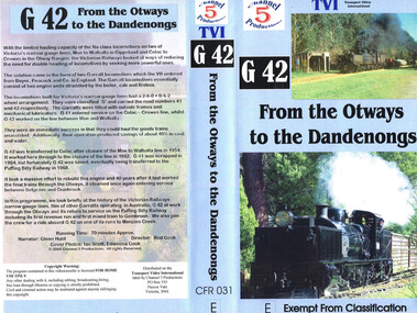
VHS Video, Channel 5 Productions, G42 From the Otways to Dandenongs, 2004
Shows footage of G42 at work in the Otways.Brief history of Australian narrow gauge lines including G42. Film of G42 at work through the Otways.g41 narrow guage railway -
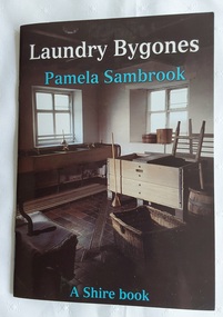 Mont De Lancey
Book, Pamela Sandbrook, Laundry Bygones, 2004
This book illustrates the simple, rare but often extremely beautiful traditional laundry aids as well as machines which were used before and in the first quarter of the twentieth century.A small brown and blue covered book, Laundry Bygones, with the title in white lettering at the top of the front cover with the author Pamela Sambrook printed in blue underneath. The cover has a full sized photograph of the old fashioned laundry at Shugborough, Staffordshire Arts and Museum Service in England. The contents show the history of laundries from the past with information as well as black and white photographs. There is a List of Further Reading and Places to Visit at the back. Pp.32.non-fictionThis book illustrates the simple, rare but often extremely beautiful traditional laundry aids as well as machines which were used before and in the first quarter of the twentieth century. laundry aids, laundry equipment, laundry irons, laundry dollies, washboards, washing machines -
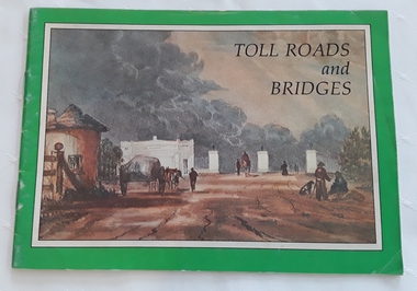 Mont De Lancey
Booklet, Department of Main Roads, Toll Roads and Bridges, 1981
A brief history of tolls used throughout history, dating back around 1950 B.C. Early English and USA use is mentioned. Road and bridge tolls in Australia were collected for construction and maintenance of particular roads and bridges similar to their use in England. The clear photographs show the development in the this country up to 1981 when the brochure was published.A small slim rectangular paperback brochure with a lithograph of the "New Toll Gate" on Parramatta Road, published in J.G. Austin's Sydney Views. Green and white edging surrounds the picture with the title Toll Roads and Bridges printed in black lettering at the top right of the cover. On the back is a photograph of Toll cabins at the northern end of the Sydney Harbour Bridge showing automatic and manual toll booths with the symbol for NAASRA and National Association of Australian State Road Authorities printed in black and white at the bottom. Pp. 20. There are many photographs inside.non-fictionA brief history of tolls used throughout history, dating back around 1950 B.C. Early English and USA use is mentioned. Road and bridge tolls in Australia were collected for construction and maintenance of particular roads and bridges similar to their use in England. The clear photographs show the development in the this country up to 1981 when the brochure was published.road tolls, roads, bridges, history of tolls -
 Wodonga & District Historical Society Inc
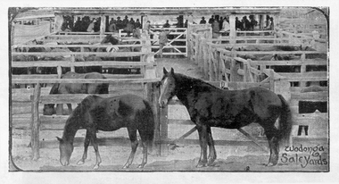
Photograph - Horse Sales at Wodonga Saleyards
The sale of stock in Wodonga goes back to its earliest history with yards being operated on the site now occupied by Elgin's Hotel and the Centro Shopping Centre, located close to the railways. Horse sales were an important part of the history of the Wodonga Saleyards. Horses were bred in north-east Victoria for the Indian Market, and records show that a truck load of horses left Wodonga Station in 1875. Campbell & Sons commenced selling horses at the Elgin Street site in 1895 and they conducted regular sales in association with Younghusband Ltd. Campbell & Sons was a Melbourne-based company, which eventually merged with Wright Stephenson & Co. Wodonga and Towong Sentinel of Friday 3rd March 1899 reported “Buyers attended from Bendigo, Ballarat, Calcutta, Madras, Singapore, The Islands, Gippsland, Dandenong, and Melbourne. Indian remounts brought up to £32 10s, draughts to £25, medium draughts to £18, town hacks and harness horses to £32, buggy pairs to £65, and light weedy sorts to £5.” After World War II, large numbers of mainly Clydesdale working horse teams were driven to Wodonga for sale. The March horse sale was the biggest and most important event of the year with overall yardings of 1,000 horses sold over two or even three days. It was a very busy period. All the horses were put through the ring singly, usually by Felix Grundy and generally caught and mouthed by Harold Boon, Andy Elliot or Toy Mulqueeney. The majority of the horses sold were trucked by rail from Wodonga. With developments in technology and the changing role of the horse in modern society, the sale of horses dwindled although horse sales at Wodonga continued until the early 1980s.These items are significant because they represent an important industry in Wodonga's past as a major centre of livestock sales in Victoria.Photographic images of horses on sale at Wodonga Saleyards.wodonga saleyards, horse sales wodonga -
 Melbourne Tram Museum
Administrative record - Depot Table Sheet or Block, Melbourne & Metropolitan Tramways Board (MMTB), "Sunday 14-1-1968 - Glenhuntly - North Fitzroy - Kew - Malvern - Doncaster", Jan. 1968
Depot table sheet or block - roneo or spirit duplicated, printed on light card - for - "Sunday 14-1-1968 - Glenhuntly - North Fitzroy - Kew - Malvern - Doncaster" shows the various runs and crew tables for the day, has an index and notes. The block was prepared for the track work to realign Dandenong Road and the Chapel St intersection as part of the St Kilda Junction project. See page 96 of Timeline History of Melbourne's Government Cable and Electric Trams - Barry George et al.trams, tramways, table cards, glenhuntly tram depot, kew depot, north fitzroy depot, doncaster depot, malvern depot, drivers, conductors, st kilda junction