Showing 187 items matching "day spring"
-
 Eltham District Historical Society Inc
Album - Photograph, J.A. McDonald, Eltham Swimming Pool, Nov. 1956
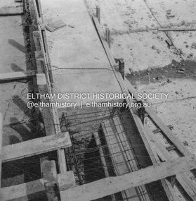
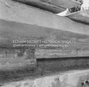
Eltham Swimming Pool Scum Gutter November 1956Record of various Shire of Eltham infrastructure works undertaken during the period of 1952-1962 involving bridge and road reconstruction projects, sometimes with Eltham Shire Council Project Reference numbers quoted. It was during this period that a number of significant improvements were made to roads and new bridges constructed within the shire that remain in place as of present day (2022). In many situations, the photos provide a tangible visible record of infrastructure that existed throughout the early days of the Shire. The album was put together by or under the direction of the Shire Engineer, J.A. McDonald.infrastructure, shire of eltham, eltham swimming pool, 1956-11 -
 Eltham District Historical Society Inc
Album - Photograph, J.A. McDonald, Eltham Swimming Pool, Nov. 1956
Eltham Swimming Pool Scum Gutter November 1956Record of various Shire of Eltham infrastructure works undertaken during the period of 1952-1962 involving bridge and road reconstruction projects, sometimes with Eltham Shire Council Project Reference numbers quoted. It was during this period that a number of significant improvements were made to roads and new bridges constructed within the shire that remain in place as of present day (2022). In many situations, the photos provide a tangible visible record of infrastructure that existed throughout the early days of the Shire. The album was put together by or under the direction of the Shire Engineer, J.A. McDonald.infrastructure, shire of eltham, eltham swimming pool, 1956-11 -
 Eltham District Historical Society Inc
Album - Photograph, J.A. McDonald, Garden Hill, Kangaroo Ground, Feb. 1963
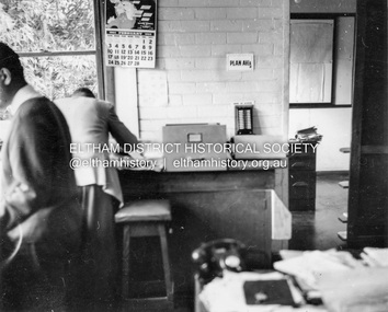
Most likley the interior of the Eltham Shire Offices at the corner of Artur Street and Main Road. The calendar is set on February 1963. ERngineering and Planning were also loacted in the shop fronts located next door on Main Road.Record of various Shire of Eltham infrastructure works undertaken during the period of 1952-1962 involving bridge and road reconstruction projects, sometimes with Eltham Shire Council Project Reference numbers quoted. It was during this period that a number of significant improvements were made to roads and new bridges constructed within the shire that remain in place as of present day (2022). In many situations, the photos provide a tangible visible record of infrastructure that existed throughout the early days of the Shire. The album was put together by or under the direction of the Shire Engineer, J.A. McDonald.arthur street, eltham, eltham shire office, main road, 1963-02 -
 Glen Eira Historical Society
Document - Christian Family
... . Springer. Day Dawn Block Christian Thomas Mines and Mining Document ...Nine pages photocopied extract of Charters Towers Centenary 1872-1972, Glimpses of Glory, edited by E.V. Springer.day dawn block, christian thomas, mines and mining -
 Eltham District Historical Society Inc
Photograph, Upper Yarra Dam, Spring Tour, 22 Oct 1995, 22/10/1995
EXPLORING THE UPPER YARRA (Newsletter No. 105, November 1995, by Bettina Woodburn) We enjoyed the Spring Excursion, this year "Exploring the Upper Yarra" - in spite of the constant rain and the countryside under the cloud cover, especially in the valleys, being mainly shiny shades of green. The occasional fields of buttercups, clumps of arum lilies and splendid rhododendron and other flowering bushes became very special. The Cobb and Co coach was warm and a cosy retreat as we zig-zagged on the highways and byways to glimpse the Yarra River, upstream and down, its secret places, and particularly the many bridges. Russell excelled as 'Poet Laureate', reading from Dacre Smyth's book. This 1979 publication includes paintings of all the bridges along the river with poems and brief descriptions of each one. Some of the bridges are in out of the way places and are not very well known. We looked forward to hearing the poetry as much as seeing the ' constructions'…Big Pat (was he short or tall, lean or fat? He did win the two hundred pound reward for discovering gold and had the creek named after him), about the 'Eddies'?, and the disliked 'meccano' bridge in Warburton, etc. etc. The hot roast lunch in the old Reefton Hotel was also most welcome. It was easy to imagine it peopled by miners and early settlers. Starting by crossing the new (1974) concrete bridge at Warrandyte we headed through Wonga Park with views to the Christmas Hills and to the escarpment of the Yering Gorge, which causes flood waters to back up through the Yarra Glen plain, so avoiding disasters downstream. At the end of a long driveway we found the wooden, privately owned Henley Bridge (1935 after the 1934 floods). This facilitates access to different parts of Henley Farm and to Lilydale. Everard Park, named after Blanche Shallard's father, a State Member for 17 years, below the Highway Yarra crossing was in need of care. It is 10 miles from Yarra Glen by road but, as "Yarra Marra” canoeists well know, 32 winding miles down by water. After more delightful countryside scenes we joined the Warburton Highway at Woori Yallock. From the old Railway Station at Launching Place the Centennial Trail for walkers, cyclists and ' horse riders has replaced the rails. The line from Lilydale was opened in 1901, and the last diesel freight train ran to Warburton in 1965. It continued to rain as we had morning tea in Warburton in a shelter between footbridges. From here we continued upstream past the Bridge to O'Shannasy Lodge and Reservoir, Starvation Creek, and the Peninsular tunnel (miners dug it as at Pound Bend) which we visited (scrambling down those steps!) on our return after lunch. Our furthermost point was the Upper Yarra Dam Reserve (and vast catchment area). Finished in 1957 after ten years work and 100 years after Yan Yean, it supplies much of Melbourne's water. After crossing the 30m Launching Place Bridge to the Eltham side of the Yarra and Healesville, we saw in the distance the Yarra Glen Timber Trestle Bridge over the river flats "the longest for years in the land it was said!" Harry's dream of "better weather over the Divide" unfortunately didn't come true, but I'm sure we 36 members will retain happy memories of a day that was wet and green and filled with Bridges. Bettina Woodburn - October 1995 Record of the Society's history of activities - Spring 1995 excursionColour photographshire of eltham historical society, activities, upper yarra dam, henley bridge -
 Eltham District Historical Society Inc
Newspaper clipping, Romantic, charming . . . ''SUNNYBROOK', Diamond Valley Local, 31 March, 1954, p4, 1954
Romantic, charming . . . ''SUNNYBROOK'' ON the slope of a hill on the East side of Bolton street and overlooking willows that trail gracefully in a creeklet which shows no great haste to blend with Diamond Creek and so to the Yarra, there stands a great old-fashioned home. Outwardly it speaks of past opulence rather than beauty of design, but the velvet green lawns and the formal neatly weeded rose gardens, the well established trees, tennis courts, wisteria covered pergolas and the great curved fronds of old palms produce an atmosphere that cannot be built-up in less than decades. Here is irresistible old-world charm. The jangle of today cannot penetrate ... it is a place to remember ... a place where events to be remembered have a perfect setting ... it is "Sunnybrook." From the neighbouring ‘Beranto Lodge’ Mrs. Lenne can catch glimpses of ‘Sunnybrook,’ but the old home is well hidden from all quarters and only the faultlessly kept lawn can be seen by the curious. Like many other people, Mrs. Lenne was curious. Who can blame her. ‘Sunnybrook’ is a name to conjure with in Eltham. When the elderly men of the township were young bucks ‘Sunnybrook’ stood alone, a proud home that was known and established. Amongst the simple homes of the valley of the Diamond Creek, ‘Sunnybrook’ was Queen. In the roistering days of the Diamond Valley, when Kangaroo Ground was the seat of the Shire and when five pubs dotted the road from Lower Plenty to the civic centre, ‘Sunnybrook’ was off the track of the boisterous and tipsy. ‘Sunnybrook’ is still off the beaten track . . . but only slightly so; it no longer looks over cow pastures, but the neat, newly built houses which dot the length of the Main Road. They are still no closer than half a mile and while these houses have sprung up the fine trees and shrubs have quietly closed in around the boundaries of ‘Sunnybrook' as if to keep the old place to itself. That is how it has become something to whet the curiosity. When the course of events put the place on the market Mrs. Lenne bought it. When a modern house is bought it is pliable in the sense that the owner moulds it according to personality. It can remain severe, utilitarian and with a little neglect soon run to an ugly shabbiness. But with old 'Sunnybrook' it is different. There is in existence a character indelibly written into every line of the place . . . it is a LOVE OF ENGLAND. Upon ‘Sunnybrook’ has been lavished the devoted love of England to such a degree that it must be seen. The gardens and lawns are formal, and though lovely and speaking of the leisure of past years they are not English . . . they are just lovely, with the beauty that only the long established seem to possess. It is inside ‘Sunnybrook’ that the intense love of England is seen. Years ago the home was bought by a Mr. Martin, who was getting on in years, as a home for his much younger wife. The couple spent thousands of pounds as well as endless care and imagination in the complete redecorating of their home. Oak panelling imported from England was built in. Huge fireplaces shed their Colonial appearance to be become the fireplaces of England . . . and they were so in every sense because they were also imported from England. One lovely specimen whose gracious lines are remarked upon by all who see it, is a certified antique of finest English Oak. Care was taken to see what hand made wrought iron light fittings were in keeping. The old place has three lounge, dining or living rooms according to taste and requirements, and all are bigger than the biggest attempted in a “big” modern home. This does not include an outside living space of ample proportions, all fine flywired in and enclosing a fernery. A turn of a tap and spray as fine as mist is released over the rockery. On a scorching summer day when no relief short of a swim could help ordinary people, the resident of ‘Sunnybrook’ found the coolness of a dell in which to sit and enjoy their evening meal. What is more, the temperature of the whole house could be reduced by merely turning on this extensive spray water system. Yes, comfort to luxury standard is built in. And what happens to 'Sunnybrook' now? Mrs Lenne is famous to thousands for her quite fabulous catering. Her home and her "Wanda Inn" at Hepburn Springs have long been a Mecca for those who want the different in catering . . . different in the sense that every client is treated as a friend, not a customer and the hospitality and attention one would give to an honoured friend is accorded. And the food! – ask anyone who has enjoyed the privilege. Ask those who attended the reception given to Mr. Menzies by Eltham Shire Council; ask those members of the Diamond Valley Chamber of Commerce who enjoyed it! [See EDHS_04736-1/2 https://victoriancollections.net.au/items/5d4c2fb521ea6727d892df72] There is only one word anyone ever uses . . . “unbelievable!” it must be seen and eaten to be believed. And ‘Sunnybrook’ will ring to the laughter, and offer its spaciousness for the fun of all who join in the happiest occasion in the life of those just married, whose wedding reception is intended to be “remembered.” Mrs. Lenne is a dynamic ball of energy whose enthusiasm is not to be brooked. She has acquired the home of her dreams. 13 March 2020 Note: Historian Stella M. Barber via the GSV members Forum cites that Clair Samwell and Doris Good ran a nursing home in Balwyn called Penquite (1946-1952). Prior to that the women had run a rest home called Beranto in Eltham. Single newsprint page separated rest of paperberanto lodge, bolton street, houses, mrs. lenne, prime minister, properties, robert gordon menzies, sunnybrook -
 Eltham District Historical Society Inc
Photograph, George Coop, A day in Melbourne, the Hotel Windsor, Spring Street, November 1962, 1962
Viewed from Gordon Reserve adjacent to Parliament House. The Gordon Fountain in foreground.Digital TIFF file Scan of 35mm Ilford FP3 black and white transparencygordon fountain, gordon reserve, hotel windsor, melbourne, parliament house, spring street -
 Eltham District Historical Society Inc
Photograph, Hume and Hovell passed here at Seymour 28 Oct 1824, Spring Excursion, Hume and Hovell's 1824 expedition (Part 2), 26 October 1997, 26/10/1997
[article by Diana Bassett-Smith in EDHS Newsletter No. 117, November 1997:] MONUMENT HUNTING THE HUME AND HOVELL WAY - Sunday October 26 1997 dawned bright and very warm. Some twenty-five members, complete with picnic baskets, met outside the Eltham Library awaiting the Cobb and Co. large coach which would be taking us on the second leg of our travels along the route of the early explorers Hume and Hovell. Stephen West was our very good driver for the day. He would be guided around the circuitous route by Russell Yeoman who had made a detailed study, not only of the intended route, but of the story of these two explorers. During the trip Russell regaled us with poetry, quotations from the Journals and the History of the Shire of Seymour, "The New Crossing Place" by Martindale, 1982, (now Mitchell Shire due to the recent amalgamations). We headed towards the Hume Highway via Greensborough and Cooper Street and proceeded north to our first stop, noting on the way Monument Hill in the distance which is near Kilmore and, according to Russell, well worth the effort to visit as the view across the valley is magnificent. Past Sunday Creek Valley, Mt Piper and Mt Disappointment, all traversed and noted and named by them. We passed through Tallarook, then onto Seymour where we took photos of the monument telling us that Hume and Hovell had passed through on the 28th of October 1824. We also deviated down Hume and Hovell Road viewing deer and emu farming and the Bellbourie property now a sanctuary. Leaving Seymour behind we travelled up the Avenel Road to the Avenel monument, pyramidal in design of four reducing square blocks with a sharply pointed peak, erected in 1924 in memory of the 1824 exploration. The day was warming up and the countryside showing the dryness of the current drought. A parallel note had been made in their journal too of 1824 of the drought appearance of the country they were traversing. At Seven Creeks, Euroa we stopped for some minutes to check the monument placed 20th November 1924 to commemorate their passage on the 29th December 1824. More photos. Russell had pointed out the abrupt termination of the distant ranges which is noted in their journal. The next monument is beside the road at the entrance to Honey Suckle Creek Caravan Park, Violet Town. The squarish shaped monument some eight feet high is topped with a simple steel cross, and was to mark the date of 28th December 1824 and built for the 20th November 1924. By now it was 12.20 and nearly lunchtime as we drove along the Warranbayne Road to Roach's Road, monument hunting without success. Though there is a large, what appears to be an old timber sign which was hard to read, maybe this was the lost monument. In many of the paddocks hay had been cut and baled or was being cut, what a contrast to the rugged country they had passed through which was smoky from the fires of the natives burning off. By 1.00 pm we were at Benalla and pulled up beside the park where abundant beds of roses filled the air with their scent and the smell of barbecued food twitched the nostrils whilst the cheerful sounds of other picnickers could be heard throughout the park. We left the bus and collected up our picnics, dispersed to the various tables and enjoyed the shade from the various European trees. 2.00 pm and we were on the road again driving along the Benalla, Mansfield, Yea road. The Swanpool monument states that they passed four miles south and returned three miles north. Then we stopped at the Barjarg monument which notes that they camped near this spot. It is again a pyramidal monument and this time topped with a steel arrow indicating their route of the 29th November 1824. Half an hour later we came to another monument, again with a steel arrow marker on top and the plaque dated the 2nd of 12th 1824. Erected on the 12th of 12th 1924. "They blazed the way that we might inherit the land." Another square based and needle topped monument appeared at Yarck near Yea and this plaque records the date of 3 December 1824. Near McGuigans Road Russell related that the expedition had lost a dog but it had found them next day, the dog was apparently torn by a kangaroo. A short while later Russell reminded us here of the problems they encountered in crossing the Goulburn River near Molesworth where banks were high, water deep and wide. "Good coat of grass but quite dry due to drought". At Yea we stopped for afternoon tea and raided the last of our picnics and looked at the monument to their journey of 1824, situated at a corner of the gardens near the bowling green. No photo – we were out of film. We returned home via Kinglake West and Whittlesea past the Yan Yean Reservoir, not full. 5.00 pm back at Eltham we emptied out of the bus and everyone, including Joan Cole, collected their things, Joan also had the major souvenir of the day, a large carp she had picked up from the river bank, her cat was in for a great feast. The day was made so interesting by the informed commentary which Russell provided. His background knowledge of the route and nature of the journey could only have come from many hours of reading and driving the area. Thank you to Russell and to everyone who made the day so informative and pleasurable. Colour photographactivities, hume and hovell, monument, seymour -
 Eltham District Historical Society Inc
Photograph, Spring Excursion, Hume and Hovell's 1824 expedition (Part 2), 26 October 1997, 26/10/1997
[article by Diana Bassett-Smith in EDHS Newsletter No. 117, November 1997:] MONUMENT HUNTING THE HUME AND HOVELL WAY - Sunday October 26 1997 dawned bright and very warm. Some twenty-five members, complete with picnic baskets, met outside the Eltham Library awaiting the Cobb and Co. large coach which would be taking us on the second leg of our travels along the route of the early explorers Hume and Hovell. Stephen West was our very good driver for the day. He would be guided around the circuitous route by Russell Yeoman who had made a detailed study, not only of the intended route, but of the story of these two explorers. During the trip Russell regaled us with poetry, quotations from the Journals and the History of the Shire of Seymour, "The New Crossing Place" by Martindale, 1982, (now Mitchell Shire due to the recent amalgamations). We headed towards the Hume Highway via Greensborough and Cooper Street and proceeded north to our first stop, noting on the way Monument Hill in the distance which is near Kilmore and, according to Russell, well worth the effort to visit as the view across the valley is magnificent. Past Sunday Creek Valley, Mt Piper and Mt Disappointment, all traversed and noted and named by them. We passed through Tallarook, then onto Seymour where we took photos of the monument telling us that Hume and Hovell had passed through on the 28th of October 1824. We also deviated down Hume and Hovell Road viewing deer and emu farming and the Bellbourie property now a sanctuary. Leaving Seymour behind we travelled up the Avenel Road to the Avenel monument, pyramidal in design of four reducing square blocks with a sharply pointed peak, erected in 1924 in memory of the 1824 exploration. The day was warming up and the countryside showing the dryness of the current drought. A parallel note had been made in their journal too of 1824 of the drought appearance of the country they were traversing. At Seven Creeks, Euroa we stopped for some minutes to check the monument placed 20th November 1924 to commemorate their passage on the 29th December 1824. More photos. Russell had pointed out the abrupt termination of the distant ranges which is noted in their journal. The next monument is beside the road at the entrance to Honey Suckle Creek Caravan Park, Violet Town. The squarish shaped monument some eight feet high is topped with a simple steel cross, and was to mark the date of 28th December 1824 and built for the 20th November 1924. By now it was 12.20 and nearly lunchtime as we drove along the Warranbayne Road to Roach's Road, monument hunting without success. Though there is a large, what appears to be an old timber sign which was hard to read, maybe this was the lost monument. In many of the paddocks hay had been cut and baled or was being cut, what a contrast to the rugged country they had passed through which was smoky from the fires of the natives burning off. By 1.00 pm we were at Benalla and pulled up beside the park where abundant beds of roses filled the air with their scent and the smell of barbecued food twitched the nostrils whilst the cheerful sounds of other picnickers could be heard throughout the park. We left the bus and collected up our picnics, dispersed to the various tables and enjoyed the shade from the various European trees. 2.00 pm and we were on the road again driving along the Benalla, Mansfield, Yea road. The Swanpool monument states that they passed four miles south and returned three miles north. Then we stopped at the Barjarg monument which notes that they camped near this spot. It is again a pyramidal monument and this time topped with a steel arrow indicating their route of the 29th November 1824. Half an hour later we came to another monument, again with a steel arrow marker on top and the plaque dated the 2nd of 12th 1824. Erected on the 12th of 12th 1924. "They blazed the way that we might inherit the land." Another square based and needle topped monument appeared at Yarck near Yea and this plaque records the date of 3 December 1824. Near McGuigans Road Russell related that the expedition had lost a dog but it had found them next day, the dog was apparently torn by a kangaroo. A short while later Russell reminded us here of the problems they encountered in crossing the Goulburn River near Molesworth where banks were high, water deep and wide. "Good coat of grass but quite dry due to drought". At Yea we stopped for afternoon tea and raided the last of our picnics and looked at the monument to their journey of 1824, situated at a corner of the gardens near the bowling green. No photo – we were out of film. We returned home via Kinglake West and Whittlesea past the Yan Yean Reservoir, not full. 5.00 pm back at Eltham we emptied out of the bus and everyone, including Joan Cole, collected their things, Joan also had the major souvenir of the day, a large carp she had picked up from the river bank, her cat was in for a great feast. The day was made so interesting by the informed commentary which Russell provided. His background knowledge of the route and nature of the journey could only have come from many hours of reading and driving the area. Thank you to Russell and to everyone who made the day so informative and pleasurable. Colour photographactivities, hume and hovell, bridge -
Federation University Historical Collection
Book - Book - Scrapbook, Ballarat College of Advanced Education: Scrapbook of newspaper cutting, Book 10; September 1981 to May 1982
Newspaper cuttings relating to Ballarat College of Advanced Education. These are from various newspapers and include The Age, Ballarat Courier, The Australian, The Herald. The cuttings cover the period from 2 September 1981 to 6 May 1982. . Book with grey cover, front. Image of image of two trotters. Spiral bound.employment advertisements, application for enrolment, outline of courses, more students less money, bcae staff cuts, fewer graduates in engineering, half marathon, need for more maths and science students, energy resources control warning, bcae spring festival, companies woo bcae engineering graduates, engineering students and 'the iron horse', recreation survey, p e degree course, energy saving project, student winemakers, tom nestor wins award, nigerian students studies ground movement, sir arthur nicholson, golden taste of success, ivan durrant on art students, critical time for ballarat's economy, first group to complete arts degree, francis brown, john mcmahon, award in metallurgy, award in mechanical engineering, pottery group's first show, rich clays of ballarat, colleges to retrench staff, retirement of frank ryan, growing computer industry, new job in northern territory, break-in brumbies, ballarat's young jobless, librarians enter computer age, tertiary chief sacked, dr jim watson, hsc seminar at bcae, students eat too much fast food, chemistry graduate to work in canberra, stephen wilson, dianne budge to work in alice springs, physical fitness director of ymca, revamp for key tertiary commission, lake weed problem, businessmen wooed, move to promote health fitness, scholarships for students, robert allan artist, move to save bendigo course, hobby course for gold prospectors, john crump ceramics, day of firsts at bcae, track and field titles win, tamara beckier artist, abstract art, talks on future of regional colleges, government funding -
 Federation University Historical Collection
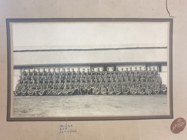
Photograph, Melba & Co, 7th Australian Infantry Training Battalion WW1
George Alfred Yung, known as Alf, pictured in the second row, 10th from the left, enlisted on 25/02/1916; embarked on 19/02/1917; was killed during the battle of Menin Gate at Yrpres, Belgium on 20/09/1917. https://www.awm.gov.au/collection/U51447 The 7th Battalion was among the first infantry units raised for the AIF during the First World War. Like the 5th, 6th and 8th Battalions, it was recruited from Victoria and, together with these battalions, formed the 2nd Brigade. The battalion was raised by Lieutenant Colonel H. E. "Pompey" Elliott within a fortnight of the declaration of war in August 1914 and embarked just two months later. After a brief stop in Albany, Western Australia, the battalion proceeded to Egypt, arriving on 2 December. It later took part in the ANZAC landing on 25 April 1915, as part of the second wave. Ten days after the landing, the 2nd Brigade was transferred from ANZAC to Cape Helles to help in the attack on the village of Krithia. The attack captured little ground but cost the brigade almost a third of its strength. The Victorian battalions returned to ANZAC to help defend the beachhead, and in August the 2nd Brigade fought at the battle of Lone Pine. While holding positions captured by the 1st Brigade, four members of the 7th Battalion, Corporal A. S. Burton, Acting Corporal W. Dunstan, Lieutenant W. Symons and Captain F. H. Tubb, earned the Victoria Cross - Burton posthumously. The battalion served at ANZAC until the evacuation in December. After the withdrawal from Gallipoli in December 1915, the battalion returned to Egypt. In March 1916, it sailed for France and the Western Front and entered the front line trenches for the first time on 3 May. The battalion's first major action in France was at Pozieres in the Somme valley where it fought between 23-27 July and 15-21 August. After Pozieres the battalion manned trenches in the Ypres salient in Belgium, before returning to the Somme valley. It saw out the horrendous winter of 1916-1917 rotating between training, working parties and duty in the trenches. In early 1917, the Germans withdrew to the Hindenburg Line and the 7th Battalion participated in the brief advance that followed and then came to a grinding halt before Bullecourt. The battalion was withdrawn from the front line for training on 9 May 1917 and did not return to action until the Ypres offensive of September and October. It fought major battles at Menin Road on 20 September and Broodseinde on 4 October, and then spent much of ensuing winter in the Ypres mud. In March and April 1918 the 7th helped stop the German spring offensive in northern France and later participated in the Allies' own great offensive of 1918, that began with the battle of Amiens on 8 August. The advance by British and empire troops on 8 August was the greatest success in a single day on the Western Front, one that German General Erich Ludendorff described as, "the black day of the German Army in this war". The battalion continued operations until late September 1918. At 11 am on 11 November 1918, the guns fell silent. The November armistice was followed by the peace treaty of Versailles signed on 28 June 1919. In November 1918 members of the AIF began to return to Australia for demobilisation and discharge. In March, the battalion was so reduced that it and the 6th Battalion were amalgamated to form a composite battalion. In turn, this battalion was merged with another, formed from the 5th and 8th Battalions, to form the 2nd Brigade Battalion. https://www.awm.gov.au/collection/U51447army, soldier, alf yung, 7th australian infantry battalion -
 Federation University Historical Collection
Book, Music Books from Suttons Music
Henry Sutton is a talented world-wide accepted inventor with inventions relating to the telephone, photography, wireless, cars, motorcycles, and bicycles as well as many more inventions. Henry was also one of four brothers that ran the Sutton's Music Store after the death of their Father Richard Sutton. Henry Sutton taught Applied Electricity at the Ballarat School of Mines in 1883 to 1886.Collection of music books that were available for purchase at Sutton's Musicmusic books, suttons music, calvary, henry vaughan, paul rodney, enoch and sons, herzelied, gustav lange, j.t. trekell, hanover edition, the desert song, one alone, kathryn grayson, gordon mcrae, otto harbach, oscar hammerstein, frank mandel, sigmund romberg, the link divine, alfred h. hyatt, piccolomini, one fine day, aria, madame butterfly opera, r.h elkin, giacomo puccini, garden of happiness, edward lockton, daniel wood, there never was a pal like you, jack o'hagan, the bridge, vocal duet, miss m lindsay, mrs j worthington bliss, songs my mother taught me, anton dvorak, blue danube, suttons brass band journal, johann strauss, macushla, josephine v rowe, dermot macmurrough, boosey and co, allans music, candle in the wind, elton john, bernie taupin, treasure chest of stephen foster songs, eddie fisher song folio, cindy oh cindy, oh my pa-pa, anytime, i need you now, then i'll be happy, sweet heartaches, dungaree doll, im in the mood for love, what a wonderful world it would be, hermann lohr, i heard you singing, royden barrie, eric coates, when you come home, fred e weatherly, w.h squire, lay down your arms, anne shelton, leon land, ake gerhard, john m williams and shaylor turners vey first piano book, i went to your wedding, jessie may robinson, patti page, mercury records, he's got the whole world in his hands, geoff love, sway, quien sera, pablo beltran ruiz, paul lombard, norman gimbel, just because the violets, kennedy russell, edwin ashdown ltd, friends of my youth, mr w burton, christy's minstrels, george barker, ideal music books, poet and peasant, melody in f, spring song, love and devotion, the storm, nachtstuck, rondoletto, blue danube waltzes, over the waves waltzes, nearer my god to thee, mignon gavotte, warum, miss clara butt, idle words, stephen adams, menuetin no. 2, the mill, liebestraum, tarantelle, la matinee, menuet, la paloma, the dove, gipsy rondo, crescendo, chanson triste, romance, tocatta in a, thora, john mccormack, john harrison, ivor foster, preclude c# minor, beautiful star of heaven, sirens song, marche militaire, fifth nocturne, sweet bye and bye, turkish patrol, valse des fleurs, melody of love, traumerei, a fragment, just for to-day, sybil f partridge, blanche ebert seaver, australian music examinations board, pianoforte-grade iii, the chappell wonder album of music, slave song, the lass with the delicate air, the bandolero, chorus gentlemen, i'll sing thee songs of araby, jest her way, venetian song, gray days, god's garden, folie bergere, weymouth chimes, un peu d'amour, you'll love me yet, s. coleridge taylor, george sutton, happy-go-lucky pete a very happy foxtrot, i know the rose, fred hall, the prisoners child, waltz ballad, russ johnston, pilgrim's cross, h.l d'arcy jaxone, frederic n. lohr, harper kearton, marie vagnolini, suttons manuscript music book, pianoforte studies, public examinations in music, light cavalry, marche hongroise, rondo alla turca, moonlight sonata, witches flight, home sweet home, narcissus, wedding march, sehnsucht, joyful peasant, les adieux, love the pedlar, caryl battersby, edward german, where will the dimple be, rosemary clooney, bob merrill, al hoffman, buttons and bows, jay livingstone, ray evans, bob hope, glen williams, british songs, cyril scott, cherry ripe, the minstrel boy, blythe and merry she was, by yon bonnie banks, all through the night, coming thro the rye, i'll bid my heart be still, classical fragments, beethoven's adieu, w. millward, wake up, a calendar of song, harold simpson, montague f. phillips, ain't misbehavin', andy razaf, thomas waller, harry brooks, robert a nelson, the ideal manuscript book, the riff song, it, one flower grows alone in your garden, ebb tide, carl sigman, robert maxwell, i'm in the mood for love, jimmy mchugh, dorothy fields, muskat ramble, edward ory, night of stars and night of love, tales of hoffmann, offenbach, the great pretender, jimmy parkinson, jerry duanne, barry frank, stan freberg, the platters, bert visser, love is a golden ring, rich dehr, frank miller, terry gilkyson, ernie sigley, d. trickey, four musical cameos, gavotte, lullaby, goblins, when children play, frank hutchens, just a closer walk with thee, jimie rodgers, west of the wall, wayne shanklin, toni fisher -
 Lorne Historical Society
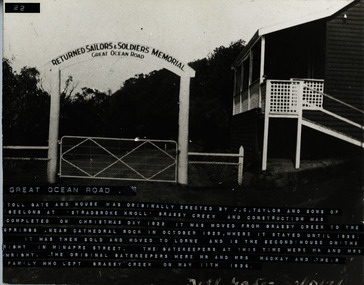
Photograph, Great Ocean Road. Tollgate and house
The toll gate and house was erected at Stradbroke Knoll, Grassy Creek by JC Taylor and sons of Geelong . Construction was completed on Christmas Day 1922. It was moved from Grassy Creek to Cathedral Rock in October 1929 where it stayed until 1936. It was then sold and moved to Lorne. It is the second house on the right in Minapre Street. The Gatehouse keepers at the time were Mr and Mrs Wright. The original Gatekeepers were Mr and Mrs MacKay. They left Grassy Creek with their family on 11 May 1926The GOR Tollgate and house were originally erected by J.C. Taylor and Sons of Geelong, at Stradbroke Knoll, Grassy Creek and construction was completed on Christmas Day 1922. It was moved from Grassy Creek to the Springs at Cathedral Rock in October 1929 where it stayed until 1936, It was then sold and moved to Lorne. It is the second house on the right in Minapre Street. The gatehouse keepers at this time were Mr. & Mrs.Wright. The original gatekeepers were Mr & Mrs Mackay. They left Grassy Creek with their family on 11th May 1926j.c. taylor and sons. gor, tollgate. -
 Eltham District Historical Society Inc
Photograph, Upper Yarra Dam, Spring Tour, 22 Oct 1995, 22/10/1995
EXPLORING THE UPPER YARRA (Newsletter No. 105, November 1995, by Bettina Woodburn) We enjoyed the Spring Excursion, this year "Exploring the Upper Yarra" - in spite of the constant rain and the countryside under the cloud cover, especially in the valleys, being mainly shiny shades of green. The occasional fields of buttercups, clumps of arum lilies and splendid rhododendron and other flowering bushes became very special. The Cobb and Co coach was warm and a cosy retreat as we zig-zagged on the highways and byways to glimpse the Yarra River, upstream and down, its secret places, and particularly the many bridges. Russell excelled as 'Poet Laureate', reading from Dacre Smyth's book. This 1979 publication includes paintings of all the bridges along the river with poems and brief descriptions of each one. Some of the bridges are in out of the way places and are not very well known. We looked forward to hearing the poetry as much as seeing the ' constructions'…Big Pat (was he short or tall, lean or fat? He did win the two hundred pound reward for discovering gold and had the creek named after him), about the 'Eddies'?, and the disliked 'meccano' bridge in Warburton, etc. etc. The hot roast lunch in the old Reefton Hotel was also most welcome. It was easy to imagine it peopled by miners and early settlers. Starting by crossing the new (1974) concrete bridge at Warrandyte we headed through Wonga Park with views to the Christmas Hills and to the escarpment of the Yering Gorge, which causes flood waters to back up through the Yarra Glen plain, so avoiding disasters downstream. At the end of a long driveway we found the wooden, privately owned Henley Bridge (1935 after the 1934 floods). This facilitates access to different parts of Henley Farm and to Lilydale. Everard Park, named after Blanche Shallard's father, a State Member for 17 years, below the Highway Yarra crossing was in need of care. It is 10 miles from Yarra Glen by road but, as "Yarra Marra” canoeists well know, 32 winding miles down by water. After more delightful countryside scenes we joined the Warburton Highway at Woori Yallock. From the old Railway Station at Launching Place the Centennial Trail for walkers, cyclists and ' horse riders has replaced the rails. The line from Lilydale was opened in 1901, and the last diesel freight train ran to Warburton in 1965. It continued to rain as we had morning tea in Warburton in a shelter between footbridges. From here we continued upstream past the Bridge to O'Shannasy Lodge and Reservoir, Starvation Creek, and the Peninsular tunnel (miners dug it as at Pound Bend) which we visited (scrambling down those steps!) on our return after lunch. Our furthermost point was the Upper Yarra Dam Reserve (and vast catchment area). Finished in 1957 after ten years work and 100 years after Yan Yean, it supplies much of Melbourne's water. After crossing the 30m Launching Place Bridge to the Eltham side of the Yarra and Healesville, we saw in the distance the Yarra Glen Timber Trestle Bridge over the river flats "the longest for years in the land it was said!" Harry's dream of "better weather over the Divide" unfortunately didn't come true, but I'm sure we 36 members will retain happy memories of a day that was wet and green and filled with Bridges. Bettina Woodburn - October 1995 Record of the Society's history of activities - Spring 1995 excursionRoll of 35mm colour negative film, 3 stripsKodak Gold 200-4shire of eltham historical society, activities, upper yarra dam, henley bridge -
 Eltham District Historical Society Inc
Photograph, Upper Yarra Dam, Spring Tour, 22 Oct 1995, 22/10/1995
EXPLORING THE UPPER YARRA (Newsletter No. 105, November 1995, by Bettina Woodburn) We enjoyed the Spring Excursion, this year "Exploring the Upper Yarra" - in spite of the constant rain and the countryside under the cloud cover, especially in the valleys, being mainly shiny shades of green. The occasional fields of buttercups, clumps of arum lilies and splendid rhododendron and other flowering bushes became very special. The Cobb and Co coach was warm and a cosy retreat as we zig-zagged on the highways and byways to glimpse the Yarra River, upstream and down, its secret places, and particularly the many bridges. Russell excelled as 'Poet Laureate', reading from Dacre Smyth's book. This 1979 publication includes paintings of all the bridges along the river with poems and brief descriptions of each one. Some of the bridges are in out of the way places and are not very well known. We looked forward to hearing the poetry as much as seeing the ' constructions'…Big Pat (was he short or tall, lean or fat? He did win the two hundred pound reward for discovering gold and had the creek named after him), about the 'Eddies'?, and the disliked 'meccano' bridge in Warburton, etc. etc. The hot roast lunch in the old Reefton Hotel was also most welcome. It was easy to imagine it peopled by miners and early settlers. Starting by crossing the new (1974) concrete bridge at Warrandyte we headed through Wonga Park with views to the Christmas Hills and to the escarpment of the Yering Gorge, which causes flood waters to back up through the Yarra Glen plain, so avoiding disasters downstream. At the end of a long driveway we found the wooden, privately owned Henley Bridge (1935 after the 1934 floods). This facilitates access to different parts of Henley Farm and to Lilydale. Everard Park, named after Blanche Shallard's father, a State Member for 17 years, below the Highway Yarra crossing was in need of care. It is 10 miles from Yarra Glen by road but, as "Yarra Marra” canoeists well know, 32 winding miles down by water. After more delightful countryside scenes we joined the Warburton Highway at Woori Yallock. From the old Railway Station at Launching Place the Centennial Trail for walkers, cyclists and ' horse riders has replaced the rails. The line from Lilydale was opened in 1901, and the last diesel freight train ran to Warburton in 1965. It continued to rain as we had morning tea in Warburton in a shelter between footbridges. From here we continued upstream past the Bridge to O'Shannasy Lodge and Reservoir, Starvation Creek, and the Peninsular tunnel (miners dug it as at Pound Bend) which we visited (scrambling down those steps!) on our return after lunch. Our furthermost point was the Upper Yarra Dam Reserve (and vast catchment area). Finished in 1957 after ten years work and 100 years after Yan Yean, it supplies much of Melbourne's water. After crossing the 30m Launching Place Bridge to the Eltham side of the Yarra and Healesville, we saw in the distance the Yarra Glen Timber Trestle Bridge over the river flats "the longest for years in the land it was said!" Harry's dream of "better weather over the Divide" unfortunately didn't come true, but I'm sure we 36 members will retain happy memories of a day that was wet and green and filled with Bridges. Bettina Woodburn - October 1995 Record of the Society's history of activities - Spring 1995 excursionRoll of 35mm colour negative film, 2 stripsKodak Gold 100-4shire of eltham historical society, activities, upper yarra dam, henley bridge -
 Eltham District Historical Society Inc
Photograph, Upper Yarra Dam, Spring Tour, 22 Oct 1995, 22/10/1995
EXPLORING THE UPPER YARRA (Newsletter No. 105, November 1995, by Bettina Woodburn) We enjoyed the Spring Excursion, this year "Exploring the Upper Yarra" - in spite of the constant rain and the countryside under the cloud cover, especially in the valleys, being mainly shiny shades of green. The occasional fields of buttercups, clumps of arum lilies and splendid rhododendron and other flowering bushes became very special. The Cobb and Co coach was warm and a cosy retreat as we zig-zagged on the highways and byways to glimpse the Yarra River, upstream and down, its secret places, and particularly the many bridges. Russell excelled as 'Poet Laureate', reading from Dacre Smyth's book. This 1979 publication includes paintings of all the bridges along the river with poems and brief descriptions of each one. Some of the bridges are in out of the way places and are not very well known. We looked forward to hearing the poetry as much as seeing the ' constructions'…Big Pat (was he short or tall, lean or fat? He did win the two hundred pound reward for discovering gold and had the creek named after him), about the 'Eddies'?, and the disliked 'meccano' bridge in Warburton, etc. etc. The hot roast lunch in the old Reefton Hotel was also most welcome. It was easy to imagine it peopled by miners and early settlers. Starting by crossing the new (1974) concrete bridge at Warrandyte we headed through Wonga Park with views to the Christmas Hills and to the escarpment of the Yering Gorge, which causes flood waters to back up through the Yarra Glen plain, so avoiding disasters downstream. At the end of a long driveway we found the wooden, privately owned Henley Bridge (1935 after the 1934 floods). This facilitates access to different parts of Henley Farm and to Lilydale. Everard Park, named after Blanche Shallard's father, a State Member for 17 years, below the Highway Yarra crossing was in need of care. It is 10 miles from Yarra Glen by road but, as "Yarra Marra” canoeists well know, 32 winding miles down by water. After more delightful countryside scenes we joined the Warburton Highway at Woori Yallock. From the old Railway Station at Launching Place the Centennial Trail for walkers, cyclists and ' horse riders has replaced the rails. The line from Lilydale was opened in 1901, and the last diesel freight train ran to Warburton in 1965. It continued to rain as we had morning tea in Warburton in a shelter between footbridges. From here we continued upstream past the Bridge to O'Shannasy Lodge and Reservoir, Starvation Creek, and the Peninsular tunnel (miners dug it as at Pound Bend) which we visited (scrambling down those steps!) on our return after lunch. Our furthermost point was the Upper Yarra Dam Reserve (and vast catchment area). Finished in 1957 after ten years work and 100 years after Yan Yean, it supplies much of Melbourne's water. After crossing the 30m Launching Place Bridge to the Eltham side of the Yarra and Healesville, we saw in the distance the Yarra Glen Timber Trestle Bridge over the river flats "the longest for years in the land it was said!" Harry's dream of "better weather over the Divide" unfortunately didn't come true, but I'm sure we 36 members will retain happy memories of a day that was wet and green and filled with Bridges. Bettina Woodburn - October 1995 Record of the Society's history of activities - Spring 1995 excursionRoll of 35mm colour negative film, 4 of 5 stripsKodak Gold 400-5shire of eltham historical society, activities, upper yarra dam, henley bridge -
 Eltham District Historical Society Inc
Photograph, Upper Yarra Dam, Spring Tour, 22 Oct 1995, 22/10/1995
EXPLORING THE UPPER YARRA (Newsletter No. 105, November 1995, by Bettina Woodburn) We enjoyed the Spring Excursion, this year "Exploring the Upper Yarra" - in spite of the constant rain and the countryside under the cloud cover, especially in the valleys, being mainly shiny shades of green. The occasional fields of buttercups, clumps of arum lilies and splendid rhododendron and other flowering bushes became very special. The Cobb and Co coach was warm and a cosy retreat as we zig-zagged on the highways and byways to glimpse the Yarra River, upstream and down, its secret places, and particularly the many bridges. Russell excelled as 'Poet Laureate', reading from Dacre Smyth's book. This 1979 publication includes paintings of all the bridges along the river with poems and brief descriptions of each one. Some of the bridges are in out of the way places and are not very well known. We looked forward to hearing the poetry as much as seeing the ' constructions'…Big Pat (was he short or tall, lean or fat? He did win the two hundred pound reward for discovering gold and had the creek named after him), about the 'Eddies'?, and the disliked 'meccano' bridge in Warburton, etc. etc. The hot roast lunch in the old Reefton Hotel was also most welcome. It was easy to imagine it peopled by miners and early settlers. Starting by crossing the new (1974) concrete bridge at Warrandyte we headed through Wonga Park with views to the Christmas Hills and to the escarpment of the Yering Gorge, which causes flood waters to back up through the Yarra Glen plain, so avoiding disasters downstream. At the end of a long driveway we found the wooden, privately owned Henley Bridge (1935 after the 1934 floods). This facilitates access to different parts of Henley Farm and to Lilydale. Everard Park, named after Blanche Shallard's father, a State Member for 17 years, below the Highway Yarra crossing was in need of care. It is 10 miles from Yarra Glen by road but, as "Yarra Marra” canoeists well know, 32 winding miles down by water. After more delightful countryside scenes we joined the Warburton Highway at Woori Yallock. From the old Railway Station at Launching Place the Centennial Trail for walkers, cyclists and ' horse riders has replaced the rails. The line from Lilydale was opened in 1901, and the last diesel freight train ran to Warburton in 1965. It continued to rain as we had morning tea in Warburton in a shelter between footbridges. From here we continued upstream past the Bridge to O'Shannasy Lodge and Reservoir, Starvation Creek, and the Peninsular tunnel (miners dug it as at Pound Bend) which we visited (scrambling down those steps!) on our return after lunch. Our furthermost point was the Upper Yarra Dam Reserve (and vast catchment area). Finished in 1957 after ten years work and 100 years after Yan Yean, it supplies much of Melbourne's water. After crossing the 30m Launching Place Bridge to the Eltham side of the Yarra and Healesville, we saw in the distance the Yarra Glen Timber Trestle Bridge over the river flats "the longest for years in the land it was said!" Harry's dream of "better weather over the Divide" unfortunately didn't come true, but I'm sure we 36 members will retain happy memories of a day that was wet and green and filled with Bridges. Bettina Woodburn - October 1995 Record of the Society's history of activities - Spring 1995 excursionRoll of 35mm colour negative film, 4 of 5 stripsKodak Gold 400-5shire of eltham historical society, activities, upper yarra dam, henley bridge