Showing 38 items
matching deep lead mine
-
 Stawell Historical Society Inc
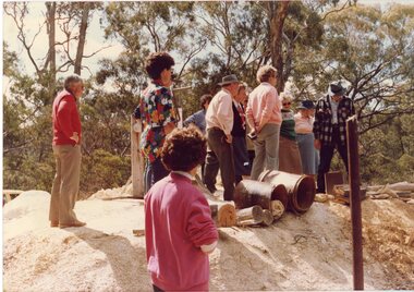
Photograph, Joe Mitchell's Mine
Stawell Historical Society Members visit Joe Mitchell's mine in the Ironbark, forest near Deep Lead. L to R Ian Jackson, Carmel Loats, Thelona Bullock, Allan Kingston, Betty Jackson, Betty Collins, Dorothy King, Leslie Bennett, Lawrie Bennett.Colour Photograph of a Group of people standing, looking down a mine shaft in bushland.mining, gold mininging, stawell historical society, deep lead -
 Stawell Historical Society Inc
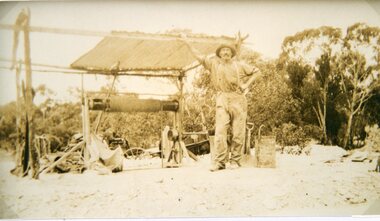
Photograph, Mr Joseph Mitchell with his mine at Campbells Gardens Deep Lead
... Mr Joseph Mitchell with his mine at Campbells Gardens Deep...Joseph Mitchell with his mine at Campbells Gardens Deep... Lead Stawell Deep Lead Mr Joseph Mitchell with his mine ...Joseph Mitchell with his mine at Campbells Gardens Deep Leadstawell deep lead -
 Stawell Historical Society Inc
Archive - CD/DVD, Stawell Historical Society 08 Gregs Mine - Stawell Historical Society Christman Breakup 2008 at Cox's Farm. Greg Camerons Mine at Deep Lead, 2008
... Camerons Mine at Deep Lead.... Camerons Mine at Deep Lead. Archive CD/DVD ...stawell -
Tarnagulla History Archive
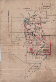
Set of Maps (Mining & Local Area), various
David Gordon Collection. A set of mining documents, maps and plans: 1. Dunolly Deep Leads - showing location and names of deep lead gold deposits in region around Dunolly including at Tarnagulla and Newbridge. Geological Survey of Victoria, Department of Minerals and Energy. Bulletin No. 62, Map No. 4 Dunolly (770 x 485 mm). 2. Poseidon Lead (Facsimile) 3. Nick O Time Lead (Facsimile) 4. Happy Go Lucky Mine prospectus and plan (colour copy) 5. Jones Creek GM Co. (Raven & Gourlay's) Waanyarra - Prospectus (colour copy) 6. Poseidon Area Plan (colour copy) and Poseidon Area map (B&W copy). 7. Cross-section diagram of Spread Eagle Reef 8. New Birthday Gold Mine - area map (colour copy) and mine cross-section ( (colour copy). 9. Cross section of Poverty Reef, by Department of Mines (B&W copy, 2 parts on A2 paper) 10. Time-Lease Graph for Watts Reef, Specimen Reef, Stony Reef, Poverty Reef (second page in detail), created by Eric WIlkinson for Ref Mining NL, 1995 11. 1859 Plan of the Gold Workings & Township of Sandy Creek, Shewing the Mining Leases, Extended Claims & Machinery by R.J. McMillan, Mining Surveyor (B&W copy) 12. Longitundinal and Transverse Vertical Sections of Poverty Reef, Sandy Creek 1859, by R.J. McMillan, Mining Surveyor (B&W copy) 13. Tarnagulla Locality Plan (B&W copy) 14. Universal Grid Reference Map (Topographic) for Laanecoorie North (2 copies) 15. Universal Grid Reference Map (Topographic) for Inglewood South 16. Poverty Reef, Plan showing shafts and early tenements, created by Eric WIlkinson for Ref Mining NL, 1995 17. Locality Map of mining leases in Tarnagulla 18. Plan and Elevation of part of Poverty Reef, Sandy Creek, showing the claims and positions of the shaft. by R.J. McMillan, Mining Surveyor (Facsimile, composed of taped together components) 19.Plan and Elevation of part of Poverty Reef, Sandy Creek, showing the claims and positions of the shaft. by R.J. McMillan, Mining Surveyor (Facsimile, composed of taped together components) -
 Tarnagulla History Archive
Linen-Backed Map of Poseidon Goldfield, c1915, with Mining Leases and Shaft locations
This is a very nice foolscap-size map, probably prepared by a Mines Department or other Government surveyor with the intention of assisting to attract mining capital to the goldfield. The red sketched-in deep lead positions are inaccurate. The pencil notation upper left reads "Lowther's Lease 6415". Lowther was a Tarnagulla mining promoter of the time. The Tarnagulla Racecourse location is marked as is the Woolshed Reef State School. -
Clunes Museum
Document - PLAN OF MINE, RIP VAN WINKLE GOLD MINING CO, 1889
After the demise of the Union Company, a third, short-lived period of deep lead mining commenced at Mount Greenock. This proved to be last mining in the area and was undertaken principally by two companies: the New Rip Van Winkle and Adam’s Freehold. These companies mined with some success through the 1880s. The Adams Freehold Company was the most preserving: it ended up sinking three shafts and operating for about ten years.PLAN OF RIP VAN WINKLE GOLD MINE COMPANY 1889 MINE ON NORTH SLOPE OF MOUNT GREENOCK VIA TALBOTEJ. SEMMENS CRESWICKlocal history, document, mining, plans -
 Bendigo Historical Society Inc.
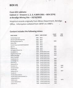
Document - MINING WARDEN COLLECTION
Historical mining records originally from the Mining Warden's Office, Mines Department, Bendigo. A summary document lists the mine name; the BEN #; the line of reef located on, the start and end year. Information collated from 1870's to 1980's. Each mine's data is enclosed in a manilla folder within the box. Mines along the following reef lines are described: Huntly Deep Lead Whipstick Neilborough Drover Isabella Slaughteryard Blue Jacket Tyson One Tree Hill Flag Gravel Hill View Hill Lightning Hill Hustlers Ben # range from 2001 to 2274. Example of entry: Pascoe and Symmonds, Ben # 2217, Lightning Hill Reef, 1863-1885.bendigo, mining, mining warden records -
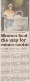 Bendigo Historical Society Inc.
Newspaper - Article on Miner Elisabeth Viklund, July 17 2022
Elisabeth Viklund has been recognised by the Mineral Council of Australia's Women in resources award.Bendigo Advertiser half page article entitled 'Women lead the way for mines sector' with coloured photo of worker in front of a loader deep below the earth's surface.bendigo, elisabeth viklund, mandalay's gold and antimony mine at costerfield