Showing 104 items
matching domestic development
-
 Flagstaff Hill Maritime Museum and Village
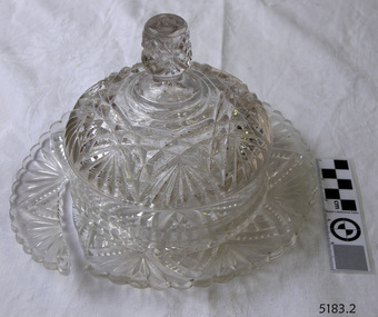
Domestic object - Butter Dish
The art of making glass can be traced back to 2600 BC in Mesopotamia. Egyptians practised making glass around 2500 BC. Artificial glass first appeared in the Egyptian or the Mesopotamian civilization, whereas they used tools made out of volcanic glass obsidian in the Stone Age. Ancient China, however, discovered how to make glass a little later. Glass beads are known to be one of the earliest products made out of glass. Their creation is thought to be primarily accidental. In the later Bronze Age, glassmaking came to a halt. Glass was a luxury material back then. Archaeological excavations suggest the use of glass in England during the middle ages. In the 10th century, stained glass found a place in cathedrals and windows of palaces. After the Renaissance, architectural methods changed substantially, leading to a decrease in stained glass as a building material. Domestic use of glass increased following the industrial revolution. Vessels, glass windows, and glass beads gained popularity in Europe during this period. During the 19th century, many people preferred glass windows and doors as a decorative option. In the late 19th century, some designers brought back stained glass in decorative windows. It was during this period that Mr Tiffany discovered several methods to make domed glass handicrafts. People discovered the true versatility of using glass as a building material only in the 20th century. With glassmaking technology receiving an industrial boom, you could produce several different types of glass. Toughened glass, laminated glass, bulletproof glass, and smart glass all boosted the use of glass in buildings. Today, several skyscrapers, small and big homes, and offices use glass in almost all aspects of construction and design. https://www.aisglass.com/glass-made-step-step-process/The invention and development of glass, both as domestic items and in building, has been nothing short of revolutionary. Prior to the use of glass for windows, the interior of buildings were extremely dark, even during sunny days. The use of glass domestic objects, that could be easily washed, led to improved hygiene.Moulded patterned glass butter dish. Base has been broken.None.flagstaff hill, warrnambool, shipwrecked-coast, flagstaff-hill, flagstaff-hill-maritime-museum, maritime-museum, shipwreck-coast, flagstaff-hill-maritime-village, glass, kitchen item, butter -
 Port Melbourne Historical & Preservation Society
Photograph - Construction of Beacon Cove, Port Melbourne, Ron Laing, 1991 - 1992
Part of Ron Laing's collection of photographs recording Port Melbourne over a thirteen year period. Donated to the PMH&PS by the photographer.A set of 73 colour photographs covering the construction of Beacon Cove (first stage of uncompleted Sandridge City Development Corporation's bayside development)built environment - domestic, ron laing, sandridge city development company pty ltd, scdc -
Port Melbourne Historical & Preservation Society
Photograph - Construction of apartment towers at Beacon Cove, Port Melbourne, Ron Laing, 1990s
Part of Ron LAING's collection of photographs recording Port Melbourne over a thirteen year period. Donated to the PMH&PS by the photographer.A set of 81 colour photographs covering the construction of the first to the fourth apartment towers of Mirvac's Beacon Cove development, between Station and Princes Piersbuilt environment - domestic, ron laing, mirvac -
Port Melbourne Historical & Preservation Society
Photograph - Devlopment of Mirvac Housing Project Stage 3, Port Melbourne, Ron Laing, 1997 - 2000
Part of Ron Laing's collection of photographs recording Port Melbourne over a thirteen year period. Donated to the PMH&PS by the photographer.One of sixty four photographs covering the development of Mirvac Housing Project, Stage 3 (BP and Engine Works sites)built environment - domestic, beacon cove, environment, ron laing -
Port Melbourne Historical & Preservation Society
Photograph - Devlopment of Mirvac Housing Project on former BP site, Port Melbourne, Ron Laing, 1986 - 1999
Part of Ron Laing's collection of photographs recording Port Melbourne over a thirteen year period. Donated to the PMH&PS by the photographer.A set of 55 colour photographs covering the development of Mirvac housing project on the ex-BP Oil Co. site from 1998built environment - domestic, environment, ron laing -
Port Melbourne Historical & Preservation Society
Photograph - Demolition of Swallow & Ariell Beach Street end and development of Anchorage apartments, Port Melbourne, Ron Laing, 1994 - 1996
Part of Ron Laing's collection of photographs recording Port Melbourne over a thirteen year period. Donated to the PMH&PS by the photographer.A set of 38 colour photographs covering the demolition of the old Swallow & Ariell biscuit factories at the Beach Street end of the site, and development of the Anchorage apartment buildingsbuilt environment - domestic, ron laing -
Port Melbourne Historical & Preservation Society
Photograph - HMAS development, Beach Street, Port Melbourne, 2012
Photographic images of properties in Port Melbourne. Image may have been taken by a PMHPS member or scanned from a past resident or taken for real estate sale purposes. Beach Street - Windows and balconies detail from HMAS development (January 2012) built environment - domestic, beach street, hmas -
Port Melbourne Historical & Preservation Society
Photograph - Beacon Cove, 2006
Photographic images of properties in Port Melbourne. Image may have been taken by a PMHPS member or scanned from a past resident or taken for real estate sale purposes. Beacon Cove; two images looking West towards the Bay showing the light rail line, bike path and waterfront developments in distance. One image includes tram. (January 2006)built environment - domestic, transport - tramways, beacon cove, light rail, tram -
Port Melbourne Historical & Preservation Society
Photograph - Former Police Quarters and Sweet Factory, Graham Street, Port Melbourne, 2000 - 2001
Further updates of Port Melbourne taken by Ron Laing (2000/1) and donated to the Society.(12) colour photos showing the site of ex Police Quarters and Sweet Factory in Graham St and re-development (Atlantis apartments)built environment - domestic -
Port Melbourne Historical & Preservation Society
Photograph - Bayview development site, Bay Street, Port Melbourne
Further updates from Ron Laing's collection of photographs of Port Melbourne and donated to the Society(13) colour photographs of the Bayview development site (ex Envelope Factory). A four tower of 8 - 10 storeys apartments with shops on street level.built environment - domestic -
 Port Melbourne Historical & Preservation Society
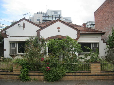
Photograph - 51 Esplanade West, Port Melbourne, c. 2010
Photograph of house formerly at 51 Esplanade west, corner of Rouse Street. House built in the inter-war period. Council approved a four 3 storey development with 8 on-site car parks in 2008. It was appealed to VCAT but unsuccessfully and the house was demolished in December 2010built environment - domestic, esplanade west -
Port Melbourne Historical & Preservation Society
Document - Submissions, Barak Road and Beacon Road developments, 1972
22 stapled pages regarding Barak & Beacon Roads development. Submissions to Minister of Lands from Cr TURNER and Cr JULIER 1972. MMBW planning map. Fishermens Bend Productivity Group working committee notes. Drawings and plans for housing, notes on developments 1955 -1972built environment - public housing, built environment - domestic, local government - city of port melbourne, leslie stanley turner, raymond frank julier, perce mcguire white, perce white, w a borthwick -
Port Melbourne Historical & Preservation Society
Plan - Montague Housing Development
Provided to PMHPS by Steve Tserkezidis and follows on from his earlier materials on the Port Melbourne State Bank houses. See item 2824. Original source Public Records OfficeCOPYRIGHT PUBLIC RECORDS OFFICE Set of plans and documents relating to the State Savings bank, Montague Housing Development, in Gladstone St, Montague. This was an initiative of South Melbourne City Council to replace slum housing in Montague, 1935-40 .03 - 40 pages; .04 - 7 pages of A2 copies (some laminated)built environment - domestic, state savings bank of victoria -
Port Melbourne Historical & Preservation Society
Plan - CD-ROM, State Savings Bank, Montague Housing Development
COPYRIGHT PUBLIC RECORDS OFFICE Set of plans and documents relating to the State Savings bank, Montague Housing Development, in Gladstone St, Montague. This was an initiative of South Melbourne City Council to replace slum housing in Montague, 1935-40 .01 - The DVD which contains all the information.built environment - domestic, state savings bank of victoria -
Port Melbourne Historical & Preservation Society
Plan - Montague Housing Development
COPYRIGHT PUBLIC RECORDS OFFICE Set of plans and documents relating to the State Savings bank, Montague Housing Development, in Gladstone St, Montague. This was an initiative of South Melbourne City Council to replace slum housing in Montague, 1935-40 .02 - 41 A4 pages including index, copies (some laminated)built environment - domestic, state savings bank of victoria -
Port Melbourne Historical & Preservation Society
Document - Report, Delapidation survey on 78 Princes St, prepared by Mirvac, 25 Sep 1995
Survey undertaken prior to Beacon Cove development, in order to prevent subsequent claims of damage by householder. Residence of Hazel WILSON. Papers found in her house after her move to a nursing home..Delapidation survey report from Mirvac Victoria for the property at 78 Princes Street, issued prior to beginning development opposite. Eight colour photos of property (outside and internal views), plus one page of observations and covering letter 1995town planning, built environment - domestic, mirvac, hazel wilson nee trembath, princes street, beacon cove -
Port Melbourne Historical & Preservation Society
Book, Allan Meiers, "Fisher Folk of Fishermens Bend", Sep 2006
Written by society member Allan Meiers, designed by Pat Grainger"Fisher Folk of Fishermans Bend" by Allan Meiers - a book providing insight into the lives of some of the fishing families that settled on Fishermans Bend during the 19th century and the contribution these families made to the early growth and development of Melbourne. Proof version.fishermans bend, coode island, domestic life, families, industry - fishing, migrants, maritime, allan meiers, johann meiers, landorf family, meiers family, prest family, beazley family, butcher family -
Port Melbourne Historical & Preservation Society
Book, Allan Meiers, "Fisher Folk of Fishermens Bend", Sep 2006
Written by society member, Allan Meiers"Fisher Folk of Fishermans Bend" by Allan Meiers - a book providing insight into the lives of some of the fishing families that settled on Fishermans Bend during the 19th century and the contribution these families made to the early growth and development of Melbourne. Published version.fishermans bend, coode island, domestic life, families, industry - fishing, migrants, maritime, allan meiers, johann meiers, landorf family, meiers family, prest family, beazley family, butcher family -
Port Melbourne Historical & Preservation Society
Photograph - Joyce Bennett sitting on fence, Fishermen's Bend, 1941
Loaned to the Vintage Port Worth Preserving project in 1990 by Doug McKenzie, Joyce's husband. Joyce was at the time suffering from Alzheimer's disease.Joyce Bennett sitting on fence 1941, with first homes of the Fishermen's Bend development in the backgroundfishermans bend, built environment - domestic, joyce bennett mckenzie, joyce bennett, doug mckenzie -
Port Melbourne Historical & Preservation Society
Book, Pat Grainger, "They Can Carry Me Out", Jan 1992
In 1990 City Librarian Wendy MORRIS commissioned Pat GRAINGER to co-ordinate a State and Council funded oral history project, the final product of which was a book printed in time for the 1992 Port Melbourne Festival. Having been sold out for two years, it was reprinted with funds from the City of Port Phillip Cultural Development fund just in time to be launched at the 2002 Festival launch held at Beacon Cove on a Yarra Tram, 22 March 2002.2002 reprint of "They Can Carry Me Out" - Memories of Port Melbourne Blue, perfect-bound paperback book with white title and black line conversion of photo of fishing boats in the Lagoon. 96 pp, reprinted March 2002fishermans bend, education - primary schools, piers and wharves - station pier, piers and wharves - waterside workers, education - kindergartens, celebrations fetes and exhibitions, transport - aviation and aerodrome, transport - ferries, transport - shipping, garden city, mission to seafarers, transport - railways, transport - horse, built environment - civic, built environment - domestic, built environment - commercial, built environment - industrial, town planning - proposals shelved - bayside, religion, arts and entertainment, livestock, sandridge lagoon, migrants, built environment - public housing, centenary bridge, local government - city of port melbourne, royal visits and occasions, police, sport - australian rules football, societies clubs unions and other organisations, natural environment, business and traders, war - world war ii, deaths and funerals, flood, domestic life, gasworks, health - general health, excelsior hall, public action campaigns, ada mary a'beckett kindergarten, wendy morris, pat grainger, g borer & co, johnny allsorts pawnbroker, mckenzies milkbar, galatos chocolates, j e earl pty ltd, faram brothers hardware, jack porritt, liardet family, porritts boot shop, vintage port worth preserving project, phyllis anderson, norman barry, david beazley, leonard george 'dugga' beazley, florence beazley, george beazley, brenda bedford, lettie bradley nee walsh, margaret bride nee polson, anne callaghan, beris campbell, tony cannatelli, john carroll, john cass, margaret couch nee smith, brian couldrey, delva crawford nee rees, 'buffie' rees, joan curtis, elvir dragovic, james edward earl, linda edman, jessie edwards, lisa edwards, trevor emmett, judy faram, doug faram, george faram, richard faram, thomas faram, allen faram, a g warren, james murdock, margaret mclean, minnie mclean, m b muir, susie fox, william gleeson, sylvia gleeson, arnold goetz, lilian 'lil' goss nee johnson, gladys gott nee mccabe, stan gravias, george henry (harry) gray, len greaney, charles hall, bertha harvey nee carey, r graham carey, mac hatfield, f patricia (pat) hawkins, tippo hayes, tom hills, bradley hinge, lloyd holmes, norah howard nee mallet, voula hronakis, lorna johnson, diane keating nee bradley, alison kelly, june kirby, bob knell, tommy lahiff, nicole lalande, bill lane, kathleen lane nee moore, j s lang, ron laing, beverley lewis, andy libbis, peter libbis, emily lock, may lowe nee irving, wendy lowenstein, micael lucas, ted mccarthy, laura mcgill nee irving, vin mcnamara, elsie median nee mccabe, maree menzel, marie mills, marlene mitchell nee sharp, david moloney, ari pipilikas, ada polson nee bellion, les profitt, ted rohan, elizabeth saunders, vanessa savvaidis, prudence sheil, chutathip silpiphat, voula skourakis, flo stark, ted tobin, thelma todd, barbara villani, erica wilson, harry bocquet, nott street state school, port melbourne library, port melbourne temperance hall, swallow & ariell ltd, business and traders - hotels -
Port Melbourne Historical & Preservation Society
Photograph - Corner Ross and Bridge Streets, Port Melbourne, Glen Stuart, c. 2000
Glen Stuart, who lives near opposite corner, took progressive photos of changes to this propertyOne of six colour views of corners of Ross and Bridge Street, showing original shop and progression of new development as photographed by Glen Stuart, 1991 and 2000: New house under construction at 200 RossDetails are in pencil on backbuilt environment - domestic -
Port Melbourne Historical & Preservation Society
Photograph - Corner Ross and Bridge Streets, Port Melbourne, Glen Stuart, c. 2000
Glen Stuart, who lives near opposite corner, took progressive photos of changes to this propertyOne of six colour views of corners of Ross and Bridge Street, showing original shop and progression of new development as photographed by Glen Stuart, 1991 and 2000: New house under construction at 200 Ross, showing milk barDetails are in pencil on backbuilt environment - domestic -
Port Melbourne Historical & Preservation Society
Photograph - Corner Ross and Bridge Streets, Port Melbourne, Glen Stuart, c. 2000
Glen Stuart, who lives near opposite corner, took progressive photos of changes to this propertyOne of six colour views of corners of Ross and Bridge Street, showing original shop and progression of new development as photographed by Glen Stuart, 1991 and 2000: New house under construction at 200 Ross, showing milk bar - long shot, verticalDetails are in pencil on backbuilt environment - domestic -
Port Melbourne Historical & Preservation Society
Photograph - Corner Ross and Bridge Streets, Port Melbourne, Glen Stuart, c. 2000
Glen Stuart, who lives near opposite corner, took progressive photos of changes to this propertyOne of six colour views of corners of Ross and Bridge Street, showing original shop and progression of new development as photographed by Glen Stuart, 1991 and 2000: View of the milk bar on southwestern cornerDetails are in pencil on backbuilt environment - domestic -
 Port Melbourne Historical & Preservation Society
Album, Alison Kelly, The Alison Kelly collection, 1987 - 1991
Alison Kelly took these photographs while resident and involved with the Mission Arts Centre. She passed them on to Pat Grainger when she left the area. Pat Grainger subsequently donated them to the Society.Alison Kelly collection: Five volumes of photographs of the Mission Arts Centre, the 'Bayside' site, and Port Melbourne, 1987 to 1991town planning - proposals shelved - bayside, piers and wharves - station pier, piers and wharves - princes pier, built environment - civic, built environment - domestic, beacons, environmental issues, missions to seamen, centenary bridge, built environment, public housing, sandridge city development co pty ltd, scdc, brian couldrey, alison kelly -
Port Melbourne Historical & Preservation Society
Document - Research report, Robyn Clinch, History of some Women of Port Melbourne, Nov 2002
... A project funded by City of Port Phillip Cultural Development ...A project funded by City of Port Phillip Cultural DevelopmentHistory of some Women of Port Melbourne, book reporting on research conducted for the Port Melbourne Historical and Preservation Society by Robyn Clinch November 2002, 61pp. Bound with black plastic comb. Colour photographs. Two black and white copies in C.22.01families, women, domestic life, robyn clinch, gabriel maree alaston dawson, mary ann 'ma' bennett mccormack, sarah jean bunsell, ethel mary howe, jane mckenna slaven, winifred mary prest woodruff, caroline jean 'minnie' coleman (kornman) beazley, jane rendall nee harrison -
Port Melbourne Historical & Preservation Society
Photograph - The Park development by Becton, Janet Bolitho, 2003
Colour photograph of 'The Park' development by Bectonbuilt environment - domestic, becton -
 Port Melbourne Historical & Preservation Society
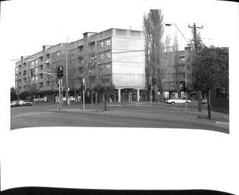
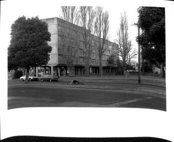
Photograph - Raglan Street Housing Commission Flats viewed from Ingles Street, Andrew U'REN, C. 1970s - 1980s
From a box of photographs in Nancy U'REN's papers used during research for her thesis, The Early Growth and Development of Sandridge (1976) and/or her book with Noel TURNBULL, A History of Port Melbourne (1983). The print was probably made by her son, Andrew U'REN, and he may have also taken the photograph.Black and white photograph of the blocks of Housing Commission flats at the corner of Ingles and Crockford Streets viewed from Ingles Street. Large white border at the bottom.A star in blue ink at the bottom left corner and details of photographic paper type and exposure details on the reverse.built environment - public housing, ingles street, crockford street, built environment - domestic, raglan street housing commission of victoria flats, nancy u'ren nee morris -
 Port Melbourne Historical & Preservation Society
Photograph - Raglan Street Housing Commission Flats viewed from Crockford Street, Andrew U'REN, C. 1970s - 1980s
From a box of photographs in Nancy U'REN's papers used during research for her thesis, The Early Growth and Development of Sandridge (1976) and/or her book with Noel TURNBULL, A History of Port Melbourne (1983). The print was probably made by her son, Andrew U'REN, and he may have also taken the photograph. The photograph includes two people on the median strip. It is unclear what they are doing or what has happened just before the photograph was taken. One person is kneeling closely over the other who appears to be lying on their back.Black and white photograph of the Raglan Street Housing Commission flats at the corner of Ingles and Crockford Streets viewed from Crockford Street. Large white border at the bottom.Details of photographic paper type and exposure details in blue ink on the reverse.built environment - public housing, ingles street, crockford street, raglan street housing commission of victoria flats, built environment - domestic, nancy u'ren nee morris -
 Port Melbourne Historical & Preservation Society
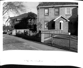
Photograph - Houses in Southward Avenue, Andrew U'REN, C. 1970s - 1980s
From a box of photographs in Nancy U'REN's papers used during research for her thesis, The Early Growth and Development of Sandridge (1976) and/or her book with Noel TURNBULL, A History of Port Melbourne (1983). The print was probably made by her son, Andrew U'REN, and he may have also taken the photograph.Black and white photograph of No 13 and No 11 Southward Avenue with other houses in the street also visible in the photograph.built environment - domestic, dunstan estate, southward avenue, nancy u'ren nee morris