Showing 35 items matching "drainage level"
-
 Melbourne Tram Museum
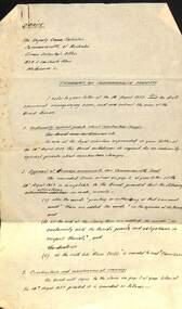
Document - Personal Papers, H. S McComb, "Tramways on Commonwealth Property", Apr. 1960
Handwritten draft on foolscap paper, titled "Tramways on Commonwealth Property", to the Deputy Crown Solicitor, Commonwealth of Australia, responding to the letter of 14/8/1959, concerning a draft agreement between the Board and the Commonwealth with suggested changes, indemnities, discharge of drainage, Maribyrnong River Bridge, vehicle or level crossings - has date of 28-4-1960 and initialled by Mr. McComb.trams, tramways, maribyrnong river bridge, agreements, commonwealth government, essendon airport, west maribyrnong -
 Ringwood and District Historical Society
Map - Plans of Subdivision, Part of Crown Allotments 35 & 39, Parish of Warrandyte
Survey maps of stages 1, 2 & 3 of residential allotments in Kalinda Road and Grayling Crescent, Ringwood, Victoria. (Undated, circa 1960). Some allotments are marked with real estate information and prices in pre decimal £s.Adshead & McGuire, Land Surveyors L.S. M.I.S. (Aust), 268 Albert Street East Melbourne (Ref 118/2a b &c) Tel 41-6960. The land colored blue is set apart for drainage & sewerage purposes. Reference Marks (R.M's) are Gal Iron Pipes 12"x1". Levels shown are to M.M.B.W. Datum. The land shown hatched is subject to innundation. -
 Ringwood and District Historical Society
Document - Plan of Subdivision, Part of Crown Allotment 31B, Parish of Warrandyte - 1965
... . Notation: "The land coloured blue is a drainage and sewerage.... Notation: "The land coloured blue is a drainage and sewerage ...Map showing residential allotments numbered 1, 2, 4 and 5, on Through Road, Ringwood, Vic., with property dimensions, including weatherboard house and galvanised iron garage on lot 2.Kirkpatrick & Webber, Licensed Surveyors, Civil Engineers & Town Planners, Maroondah Highway, Ringwood, Telephone 8700321. Ref 3438C. Date 4th December, 1964. Amended 19th July, 1965. Notation: "The land coloured blue is a drainage and sewerage easement. Levels are to Board of Works Datum. Lot number 3 has been omitted." -
 University of Melbourne, Burnley Campus Archives
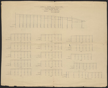
Plan, Burnley School of Agriculture Proposed Drainage Area Plan Shewing (sic) Sections, 1930
... to the Agricultural Superintendent from the Principal. (2) Levels over... Superintendent from the Principal. (2) Levels over Proposed Drainage Area ...From A.W Jessep file "Improvements (Completed)"Hand drawn. (1) Includes Memorandum dated 25.7.30 to the Agricultural Superintendent from the Principal. (2) Levels over Proposed Drainage Area. From A.W. Jessep file, "Improvements (Completed)." Additional memorandum from the Agricultural Superintendent to Principal (1 folio page)burnley school of agriculture, drainage, drainage pipes -
 University of Melbourne, Burnley Campus Archives
Plan, Duck Pens at Burnley Competitions. Plan of Floor No 1, c. 1940
Hand drawn plan, coloured. Plan of Floor of Duck Pens with Level for Drain. Imperial measurements, so before 1966.duck pens, drainage