Showing 678 items matching "enlarger"
-
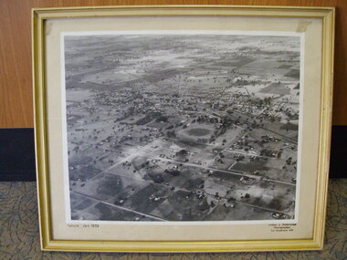 Tatura Irrigation & Wartime Camps Museum
Photograph, Aerial Photograph, Jan-59
Framed enlarged aerial photograph of Tatura, January 1959.Tatura Jan 1959tatura, photography, photograph, slides, film -
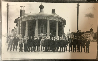 Canterbury History Group
Photograph - Canterbury Post Office Staff, c1931
Photograph of post office staff outside the Canterbury Post Office c.1931 with names included. Black and white photograph. Enlarged from photograph no 138canterbury, canterbury post office, canterbury road, maling road, postal workers -
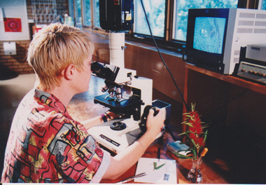 University of Melbourne, Burnley Campus Archives
Photograph - Colour print, Fujifilm, Student in the Laboratory, Unknown
2 colour photographs, 1 enlarged, of a student in the Laboratory.students, laboratory, student inside class -
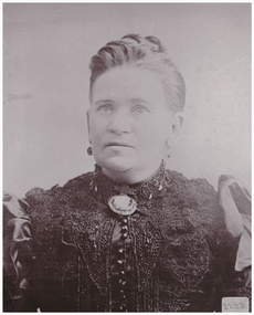 Linton and District Historical Society Inc
Photograph, Mrs Ambrose Murrell, née Mary May
Mary Murrell and her husband Ambrose Murrell owned and ran the Victoria Hotel in Linton from about 1881. After Ambrose died in 1891, she continued to run the hotel with the assistance of her daughter Caroline.Enlarged photograph of Mrs Mary Murrell, mounted on cardboard.mary murrell, mary may -
 Tatura Irrigation & Wartime Camps Museum
Post Card, Anglican Church and Vicarage, 1921
Post card of Church c 1921 and Vicarage 1921. See L0599 for enlarged and framed picture of above; and L0600 for enlarged and framed photograph of Anglican Church c 1960.All Saints all saints church and vicarage tatura -
Tatura Irrigation & Wartime Camps Museum
Photograph - framed, Goulburn Valley Picture Framing, Anglican Church and Vicarage, 1921
Enlarged and framed picture of Church and Vicarage. See L0758 Post card of Church c 1921 and Vicarage 1921; and L0600 for enlarged and framed photograph of Anglican Church c 1960.All Saints all saints church and vicarage tatura -
Tatura Irrigation & Wartime Camps Museum
Photograph - framed, Goulburn Valley Picture Framing, Anglican Church and Vicarage, 1921
enlarged and framed photograph of Anglican Church c 1960. See L0758 Post card of Church c 1921 and Vicarage 1921; and L0599 Enlarged and framed picture of Church and Vicarage. All Saints all saints church and vicarage tatura -
 Greensborough Historical Society
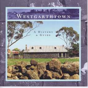
Book, Westgarthtown: a history and guide, 2004_
A short history of Westgarthtown (Thomastown Historic Precinct)Revised and enlarged edition. 44 p., illus. (some col.)westgarthtown -
 Ringwood and District Historical Society
Booklet - Newsletter, Warrandyte Historical Society - Gold Mining In Warrandyte - A Brief History, by Murray Houghton
Revised and enlarged from an earlier Warrandyte Historical Society document -
 Bendigo Historical Society Inc.
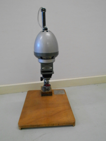
Tool - DONEY COLLECTION: DUPONT UNIPRINT 37 PHOTOGRAPHIC ENLARGER
Dupont Uniprint Photographic Enklarger Includes Enlarger manufacture's instructionsDupont -
Whitehorse Historical Society Inc.
Map, Springvale Road, c1970
Enlarged aerial photo of intersection of Springvale and Whitehorse Roads, Nunawading.Enlarged aerial photo of intersection of Springvale and Whitehorse Roads, Nunawading.Enlarged aerial photo of intersection of Springvale and Whitehorse Roads, Nunawading.springvale road, nunawading, whitehorse road, nunawading, maroondah highway, nunawading, aerial photographs -
 Linton and District Historical Society Inc
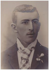
Photograph, William Murrell
William Murrell was a son of Ambrose and Mary Murrell, who ran the Victoria Hotel in Linton from about 1881. William lived in Daylesford for some years, but returned to live in Linton, where he ran the newsagency. His daughter Carrie Murrell assisted him and eventually took over the management of the newsagency. William Murrell married Lily Clarke (also known as Lily Young), the daughter of Jimmy Clarke (J.Y. Clarke) who ran a tobacconist shop in Linton for many years.Enlarged sepia photograph of Mr William Murrell, mounted on cardboard.william murrell -
 University of Melbourne, Burnley Campus Archives
Photograph - Black and white print, E.M. Gibson, Bill Goodman, 1949-1950
Bill Goodman was a Cronin Memorial Scholar, President of the Royal Institute of Parks and Recreation 1977/78 and had a Churchill Fellowship. Part of the E.M. Gibson CollectionEnlarged photograph of Bill Goodman, Cronin Scholar, working in the Orchard. bill goodman, orchards, cronin memorial scholar, president, royal institute of parks and recreation, churchill fellowship, e.m. gibson collection, student -
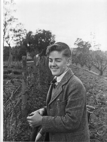
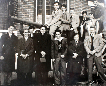 Williamstown High School
Senior boys on excursion 1940s
Copy of black and white photograph mounted on board. Also includes a caption mounted on board.Senior boys on excursion. Enlarged copies donated by Bruce Porter. 1940swilliamstown high school, 1940s, excursion -
Whitehorse Historical Society Inc.
Map, Walker Park, Nunawading, c1970?
Enlarged aerial photograph of area of Walker Park, Nunawading, 1970 runEnlarged aerial photograph of area of Walker Park, Nunawading, 1970 run.Enlarged aerial photograph of area of Walker Park, Nunawading, 1970 runwalker park, whitehorse road, nunawading, maroondah highway, dunlavin road, nunawading, mitcham technical school, aerial photographs -
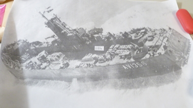 National Vietnam Veterans Museum (NVVM)
Photograph
Enlarged Black & White photo of the landing ship "Clive Steele AV1356"photograph, clive steele (a v1356) -
Bialik College
Mixed media - Soft mounted enlarged Year 12 group photographs for 2018; 2019
Year 12 group photographs for 2018; 2019Soft mounted enlarged Year 12 group photographs for 2018; 2019bialik college, 2018, 2019, year 12 -
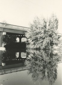 Lakes Entrance Historical Society
Photograph - Mitchell River bridge Bairnsdale Victoria, G A Legg Bairnsdale, 1975 c
Precast piles and beams were manufactured in Bairnsdale. Bridge opened 13 August 1958Black and white enlarged photograph of Mitchell River bridge Bairnsdale Victoriabridges, township, rivers -
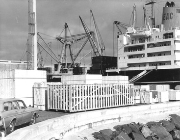 Glenelg Shire Council Cultural Collection
Photograph - Photograph - cranes loading containers onto a ship, 1980s
Port of Portland Authority archivesFront: (no inscriptions) Back: Pencil crop marks and enlarging instructions over back.port of portland archives, cargo, cargo handling, portland harbour -
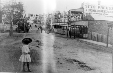 Surrey Hills Historical Society Collection
Photograph, Empire Day in Surrey Hills circa 1912
Empire Day celebrations were held from 1908-1912. Prior to the opening of the railway in 1893 the only public transport to Surrey Hills was the Melbourne-Lilydale horse coach which travelled to Surrey Hills down Victoria Street and Mont Albert Road. The fare to Union Road was 9 pence. Photo 16-4a was the number given to the original print provided by the State Savings Bank. Ken Hall made a negative from it, and the reprint of this was given the number 1459. This number was chosen as the catalogue number to avoid confusion with SHP4a. Photo provided by Surrey Hills branch of State Savings Bank of Victoria in 1978 for launch of Surrey Hills Neighbourhood Centre and was one of the first photos in the collection. The inscriptions on the reverse may indicate it was used in the Surrey Hills Neighbourhood News.Black and white photo of Union Road looking south towards Canterbury Road. The street is decorated with lanterns and the Union Jack and other flags for Empire Day celebrations. There is a young girl in the foreground looking towards the railway crossing where there is a horse drawn cab and a horse drawn cart. Business signage includes that for a butcher, Sneddon's Real Estate and Otto Preuss, Economic Undertaker.On rear: "113% "; "Enlarge to 172 mm" and 2 arrows, all in blue biro.union road, empire day celebrations, horse drawn vehicles, undertaker, sneddon real estate, businesses, union road shops, otto preuss -
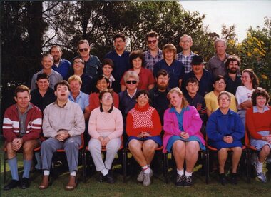 Vision Australia
Photograph - Image, QBIC workers on the Annerley Campus of Yeronga TAFE
A group of QBIC workers and administrative staff. This image was used in the book "Vision Queensland, QBIC and Queensland Industrial Institution: a history 1883-1998" by Basil Shaw. Left to Right: Back row: Lionel Hubon, John Reed, Alan Nemeth, Lindsay Arndt, Kevin Watts, Tom Chawner. Third row: Sam McCord, Colin Ingram, Diane King, Jenny Scown, Andrew Brown, Lloyd Miles, Michael Thorn. Second row: Kenny Rogers, Yvonne Lord, Joe Seeto, Duncan Collard, Richard Howell, Greg Bond, Mark Pelgrave, May Brown. Front row: Tom Rowe, Michael Bor, Vicki Waugh, Anne Van Bekkum, Cathie Dendrik, Barbara Harding, Anne Maree O'Connell.1 x col. photograph of peopleProperty of Sam McCord - please return 20 Enlarge to 2 col wideemployment, qbic industries, lionel hubon, john reed, alan nemeth, lindsay arndt, kevin watts, tom chawner, sam mccord, colin ingram, diane king, jenny scown, andrew brown, lloyd miles, michael thorn, kenny rogers, yvonne lord, joe seeto, duncan collard, richard howell, greg bond, mark pelgrave, may brown, tom rowe, michael bor, vicki waugh, anne van bekkum, cathie dendrik, barbara harding, anne-marie o'connell -
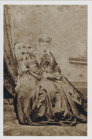 Uniting Church Archives - Synod of Victoria
Photograph, 1999
For an excellent history of Joseph Orton, see Heather Le Griffon, Campfire at the Cross. Sarah Jane Orton (née Bragg) was born 1796 and died in 1877. Twelve children, four of whom died in childbirth. Married Joseph Orton in 1815. Letters from Joseph in Jamaica to Sarah can be found at http://acms.sl.nsw.gov.au/_transcript/2012/D14750/a3991.htm.Sepia portrait photo of Mrs Orton seated. Enlarged version of F267-1."Mrs Sarah Orton"orton, sarah jane, orton, joseph -
Whitehorse Historical Society Inc.
Map, Whitehorse Road, Blackburn, 1970
Enlarged aerial photograph of area around intersection of Whitehorse and Middleborough Roads, BlackburnEnlarged aerial photograph of area around intersection of Whitehorse and Middleborough Roads, BlackburnEnlarged aerial photograph of area around intersection of Whitehorse and Middleborough Roads, Blackburnwhitehorse road, blackburn, middleborough road, blackburn, maroondah highway, box hill, aerial photographs -
Whitehorse Historical Society Inc.
Map, Canterbury Road, Blackburn, 1972
Enlarged aerial photograph of area around the intersection of Canterbury and Middleborough Roads, Blackburn.Enlarged aerial photograph of area around the intersection of Canterbury and Middleborough Roads, Blackburn.Enlarged aerial photograph of area around the intersection of Canterbury and Middleborough Roads, Blackburn.canterbury road, blackburn, middleborough road, blackburn, box hill, craig street, blackburn, hirst street, blackburn, aerial photographs -
Whitehorse Historical Society Inc.
Map, Blackburn Road, Blackburn, 1970
Enlarged aerial photograph of area around the intersection of Blackburn and Canterbury Roads, Blackburn.Enlarged aerial photograph of area around the intersection of Blackburn and Canterbury Roads, Blackburn.Enlarged aerial photograph of area around the intersection of Blackburn and Canterbury Roads, Blackburn.canterbury road, blackburn, blackburn road, blackburn, rosslyn street, blackburn south, masons road, blackburn, lavelle street, blackburn, vernon street, blackburn, wirreanda court, blackburn, aerial photographs -
Whitehorse Historical Society Inc.
Map, Blackburn, 13/01/1977 12:00:00 AM
Enlarged aerial photograph of Blackburn Business Centre. Scale 1:150 metric.Enlarged aerial photograph of Blackburn Business Centre. Scale 1:150 metric.Enlarged aerial photograph of Blackburn Business Centre. Scale 1:150 metric.blackburn, blackburn road, blackburn, south parade, blackburn, railway road, blackburn, maroondah highway, blackburn, whitehorse road, blackburn, chapel street, blackburn, albert street, blackburn, queen street, blackburn, station street, blackburn, blackburn railway station, blackburn primary school, no. 2923, aerial photographs -
Hume City Civic Collection
Photograph, Jacksons Creek Viaduct
The four arch railway bridge, known as the Jacksons Creek Viaduct Bridge, spans the Jacksons Creek north of the Sunbury Railway Station. The weir at the base of the bridge was used to dam water as well as ensuring a water supply for the steam trains. The pump house at the base of the bridge was where the water was pumped and then taken to the railway station for the steam engines.This bridge is one of notable four railway bridges along the railway line that are in Sunbury. An enlarged black and white photograph with a white border of a high bridge over a watercourse.bridges, jacksons creek viaduct, jacksons creek viaduct bridge, railways -
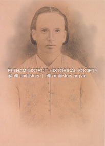 Eltham District Historical Society Inc
Photograph, Sketch from a photograph: Sarah Ann Shillinglaw (nee Kidd)
Photo print copy of copy of a drawing made of an image of Phillip and Sarah Ann Shillinglaw (nee Kidd) and children, c.1878-1879marg ball collection, 1878, sarah ann shillinglaw (nee kidd) (1850-1891) -
Phillip Island and District Historical Society Inc.
Photograph, c 1895
Sunday School Picnic - children standing and seated mostly in dark coloured clothing all in hats and caps. Three teachers also in best Sunday clothing and hats. Bracken fern in foreground.Close-up enlarged photograph of Sunday School children with their teachers, Bourne Creek, Kilcundalocal history, photography, photographs, slides, film, sunday school picnic, sepia photograph, miss elms san remo -
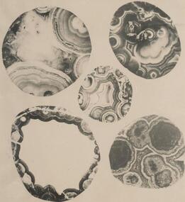 Phillip Island and District Historical Society Inc.
Photograph
One of a collection of over 400 photographs in an album commenced in 1960 and presented to the Phillip Island & Westernport Historical Society by the Shire of Phillip IslandPhotograph of five polished surfaces of Amygdales from Pyramid Rock. Enlarged by four times.local history, photography, polished amygdales, black & white photograph, geology, john jenner, bryant west