Showing 35 items matching "examination table"
-
 Department of Energy, Environment and Climate Action
Fire Finder
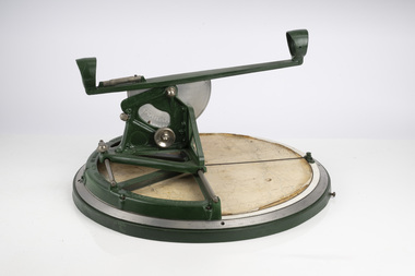
Victoria once had well over one hundred fire lookouts and firetowers. Fire lookouts, or observation posts, were often just a clearing on a hill or a vantage point, whereas firetowers were definite structures. Many were established by the Forests Commission Victoria (FCV) in the 1920s, but the network was expanded rapidly in response to recommendations of the Stretton Royal Commission after the 1939 Black Friday bushfires. When a fire or smoke was spotted from the tower a bearing was taken with the alidade and radioed or telephoned into the district office. It was then cross referenced with bearings from other towers on a large wall map to give a "fix" on the fire location. Alidades and telescopes were used in the post war period but were replaced with a much simpler map table and reference string suspended from the centre of the tower cabin. This "Fire Finder" was used in Canadian fire towers to identify the location of wildfires. The unique design was first developed by the British Columbia Forest Service (BCFS) in the early 1950s. Close examination of the map indicates that this particular Fire Finder may have been once used at Bluejoint Mountain lookout in Granby Provincial Park. This Fire Finder was a gift to Barry (Rocky) Marsden from the British Columbia Forest Service in the late 1980s in recognition of the close relationships that had been forged with the staff at the Altona Workshops over many decades. Fire Finders were originally painted black but this one was repainted green after it arrived at Altona. The BC Forest Service had a large facility where they manufactured Fire Finders and many other items of equipment, but in the 1980s it was shut down. Heavy cast iron circular object with a paper topographic map mounted on it. The metal dial and ruler works similar to a compass. The sight tube is used to determine the bearing and elevation of the fire on the map. This Fire Finder also sometimes known as an Alidade. Its a different design from the Osborne Fire Finder widely used in North American fire lookouts from the 1920s. British Columbia Forest Service. Model 62A. Serial Number 6308.bushfire -
 Department of Energy, Environment and Climate Action
Fire Finder
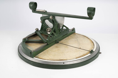
Victoria once had well over one hundred fire lookouts and firetowers. Fire lookouts, or observation posts, were often just a clearing on a hill or a vantage point, whereas firetowers were definite structures. Many were established by the Forests Commission Victoria (FCV) in the 1920s, but the network was expanded rapidly in response to recommendations of the Stretton Royal Commission after the 1939 Black Friday bushfires. When a fire or smoke was spotted from the tower a bearing was taken with the alidade and radioed or telephoned into the district office. It was then cross referenced with bearings from other towers on a large wall map to give a "fix" on the fire location. Alidades and telescopes were used in the post war period but were replaced with a much simpler map table and reference string suspended from the centre of the tower cabin. This "Fire Finder" was used in Canadian fire towers to identify the location of wildfires. The unique design was first developed by the British Columbia Forest Service (BCFS) in the early 1950s. Close examination of the map indicates that this particular Fire Finder may have been once used at Bluejoint Mountain lookout in Granby Provincial Park. This Fire Finder was a gift to Barry (Rocky) Marsden from the British Columbia Forest Service in the late 1980s in recognition of the close relationships that had been forged with the staff at the Altona Workshops over many decades. Fire Finders were originally painted black but this one was repainted green after it arrived at Altona. The BC Forest Service had a large facility where they manufactured Fire Finders and many other items of equipment, but in the 1980s it was shut down. Heavy cast iron circular object with a paper topographic map mounted on it. The metal dial and ruler works similar to a compass. The sight tube is used to determine the bearing and elevation of the fire on the map. This Fire Finder also sometimes known as an Alidade. Its a different design from the Osborne Fire Finder widely used in North American fire lookouts from the 1920s. British Columbia Forest Service. Model 62A. Serial Number 6308.bushfire -
 Melbourne Tram Museum
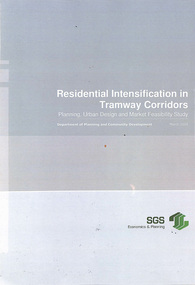
Document - Report, SGS Economics and Planning, "Residential Intensification of Tramway Corridors", May. 2009
Report - 130 pages - wire bound, plastic and card covers, titled "Residential Intensification of Tramway Corridors", prepared for the Department of Planning and Community Development by SGS Economics and Planning March 2009. Look at the development along the Nicholson St and the West Preston lines in particular. Does a detail examination of the development opportunities, including major sites that were available at the time. Does not appear to address how to capture the value of having a tram line along these areas or how to provide additional services. Development has taken place since along these and other corridors. Final Report. Table of contents and Executive Summary scanned.trams, tramways, tram routes, east preston, nicholson st, passengers, development -
 Flagstaff Hill Maritime Museum and Village
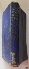
Book - Technical Reference, James Tait, Extra Master and Author et al, Tait's Home Trade Guide to the Board of Trade Examinations for Mates and Masters, 1943
The book includes navigational information, tables and maps, diagrams and formulas. It was written for Examiners and Students studying for their nautical Mates and Masters marine qualifications— notes have been handwritten inside the front and back covers. Notes in point form: 1. I have seen the back of a torpedo EBoat or UBoat in my starboard side 2. I _ _ _ to - - - - - - - - - Port side 3. at a distance ----------- 4. Enemy surface vessel in sight __________ 5. suspicious vessel in sight 6. enemy (undecipherable) 7. I have cut a _ _ _ adrift with my _ _ 8. FI_ _ WISE _ _ _ 9. STARWISE 0. OPEN FIREThis relatively rare book provided up-to-date navigational information during World War II. It was to be used by Examiners to assess whether students qualified to be a Ship's Mate or Ship's Master. The contents of the book were based on maritime knowledge gained over centuries. It is an aid to understanding the navigational methods of the time and the changes and improvements in more recent history.Title: Tait's Home Trade Guide: to the Board of Trade Examinations for Mates and Masters Author: James Tait, Extra Master Publisher: Brown, Son and Ferguson, Ltd. Glasgow, Great Britain Date: Revised Edition 1943 Further Information: Fourteenth Edition 1941, Reprinted Edition 1943. Revised and brought up to date by Captain H. T. Jefferys, Extra Master Printed by Nautical Press, Brown, Son & Ferguson, Limited, 52-58 Darnley Street, Glasgow Hardcover, small book, royal blue cover, silver embossed text on spine. Textbook for Mariners. Includes tables and maps, diagrams and formulas, and navigational information. The inside covers of this book contain handwritten calculations, diagrams and notes that refer to navigation. Notes inside the back cover refer to an enemy vessel and OPEN FIRE.Spint, in silver embossing "TAIT'S HOME TRADE GUIDE" Handwritten inside the back cover "R.A.D. / MOORE / PT. WELCH" Included with the text inside the back cover "Gascoyne" "506" and "RCM"flagstaff hill, warrnambool, shipwrecked coast, flagstaff hill maritime museum, maritime museum, shipwreck coast, flagstaff hill maritime village, great ocean road, james tait, brown, son and ferguson limited, torpedo, open fire, pt welch, vessel gascoyne, e-boat, u-boat, marine technology, world war ii, wwii, ww2, navigation exams, ship's mate, ship's master, wwii textbook, nautical textbook, navigational textbook, examination textbook, world war ii textbook, 1943 nautical textbook -
 Warrnambool and District Historical Society Inc.
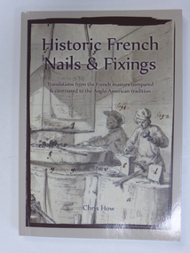
Book, Historic French Nails and Fixings, 2017
This book contains information on historic French nails and fixings, being translations from the French Masters compared and contrasted to the Anglo-American tradition. It has been compiled by Chris How, a retired Civil/Structural Engineer who lives in Warrnambool, Victoria. He has been involved with conservation and heritage buildings for half a century and it was working with pioneer materials and techniques that first stimulated his interest in historic nails. He has completed a Master’s degree in England and made a special study of French and Germanic framing and its spread across Europe. This involved similar studies in Denmark, Belgium, the Baltic countries and Australia. This book is of interest because it was written by a local Warrnambool resident, one who has researched and studied many buildings in Warrnambool and district through an examination of the building materials used, especially the nails and fixings. This is a soft cover book of 126 pages The cover is grey with a grey, black and white sketch on the front cover and a colour photograph on the back page. The book has contents pages, a list of tables and figures, a list of the source of illustrations and credits, a foreword, acknowledgements, a preface, eight chapters, a glossary of terms and appendices. There are many black and white and colour illustrations. chris how, history of nails, history of warrnambool