Showing 85 items
matching first town plan
-
 Federation University Historical Collection
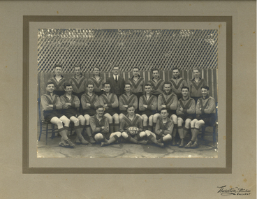
Photograph - Photograph - black and white, Ballarat Teachers' College Football Team, 1928, 1928
This photo was taken at the Ballarat East Town Hall. The Ballarat Teachers' College was established after the Victorian State Government and the State Education Department decided to establish two provincial teachers' colleges, at Ballarat and Bendigo. On 04 May 1926 W.H. Ellwood (Principal), Miss A. Bouchier, and Mr A.B. Jones, welcomed the first enrolment of 61 students to undertake the one year course. In 1927 the College moved to the former Ballarat East Town Hall in Barkly Street, which was remodelled for their use. It closed in December 1931 due to the Great Depression. In 1946 Ballarat Teachers' College reopened and relocated to the Dana Street State School. The building used by the Teachers' College was the original bluestone building facing Doveton Street South. It was originally planned to open as a women's college, for whom the residence at 130 Victoria Street was purchased, but the decision was made to admit resident men from Ballarat. Mr T.W. Turner was appointed as Principal in 1951 and directed the introduction of a two year course for the Trained Primary Teachers' Certificate. The former one year course was terminated at the end of 1951. In 1958 the College was relocated to a custom built facility at Gillies Street, in close proximity to the Ballarat Botanical Gardens. Numbers increased with the introduction of the Trained Infant Teachers' Certificate course under the guidance of Mary Egan. With the introduction of a three year Diploma Course in 1968 accommodation became cramped. The introduction of the Diploma of Teaching (Primary) led to the Trained Infant Teachers' Certificate being discontinued in 1969, and the end of the Trained Primary Teachers' Certificate in 1969. Secondary Art and Craft students began studies at Ballarat Teachers' College in 1969 under Mr Ted Doney. In 1971 Mr D. Watson was appointed Principal. The State College of Victoria was proclaimed by Order in Council on 24 July 1973, and Ballarat Teachers' College became a constituent college of the State College of Victoria, and was known as State College of Victoria, Ballarat. By 1975 the College moved to Mount Helen as part of the Ballarat College of Advanced Education. Pre service teachers currently undertake their studies on the Mount Helen Campus of Federation University. ("Ruffians Attempted to Carry of the School Tent: A History of State Education in Ballarat", 1974, p73-4.)Mounted photograph of the football team of the Teacher Training College Ballarat. Ron Robson is 3rd from the right in the centre row. He later lived at Merbein, Victoriaballarat teachers' college, teacher training college ballarat, football, ballarat teachers' college football team, thornton studios, ballarat east town hall -
 Federation University Historical Collection
Programme - Card, Ballarat Teachers' Reunion Souvenir, 1933, 1933
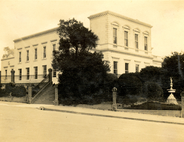
This card was used by John McNaughton, student of the Ballarat Teachers' College in 1929. The Ballarat Teachers' College was established after the Victorian State Government and the State Education Department decided to establish two provincial teachers' colleges, at Ballarat and Bendigo. On 04 May 1926 W.H. Ellwood (Principal), Miss A. Bouchier, and Mr A.B. Jones, welcomed the first enrolment of 61 students to undertake the one year course. In 1927 the College moved to the former Ballarat East Town Hall in Barkly Street, which was remodelled for their use. It closed in December 1931 due to the Great Depression. In 1946 Ballarat Teachers' College reopened and relocated to the Dana Street State School. The building used by the Teachers' College was the original bluestone building facing Doveton Street South. It was originally planned to open as a women's college, for whom the residence at 130 Victoria Street was purchased, but the decision was made to admit resident men from Ballarat. Mr T.W. Turner was appointed as Principal in 1951 and directed the introduction of a two year course for the Trained Primary Teachers' Certificate. The former one year course was terminated at the end of 1951. In 1958 the College was relocated to a custom built facility at Gillies Street, in close proximity to the Ballarat Botanical Gardens. Numbers increased with the introduction of the Trained Infant Teachers' Certificate course under the guidance of Mary Egan. With the introduction of a three year Diploma Course in 1968 accommodation became cramped. The introduction of the Diploma of Teaching (Primary) led to the Trained Infant Teachers' Certificate being discontinued in 1969, and the end of the Trained Primary Teachers' Certificate in 1969. Secondary Art and Craft students began studies at Ballarat Teachers' College in 1969 under Mr Ted Doney. In 1971 Mr D. Watson was appointed Principal. The State College of Victoria was proclaimed by Order in Council on 24 July 1973, and Ballarat Teachers' College became a constituent college of the State College of Victoria, and was known as State College of Victoria, Ballarat. By 1975 the College moved to Mount Helen as part of the Ballarat College of Advanced Education. Pre service teachers currently undertake their studies on the Mount Helen Campus of Federation University. ("Ruffians Attempted to Carry of the School Tent: A History of State Education in Ballarat", 1974, p73-4.)Printed card with a black and white photo of the Ballarat Teachers' College (former Ballarat East Town Hall).ballarat teachers' college, mcnaughton, john mcnaughton, former ballarat east town hall, ballarat east gardens -
 Federation University Historical Collection
Magazine, Greenhill Enterprise Centre Magazine
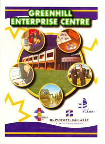
This magazine was probably a supplement of the Ballarat Courier at the time of the opening of the Greenhill Enterprise Centre, Ballarat Technology Park. 31 October 1997 - Official opening of Greenhill Enterprise Centre by the Hon. Alan Stockdale, Treasurer and minister for multimedia. Coloured magazine of 18 pages relating to the Greenhill Enterprise Centre. Contents include: * What is an enterprise Centre? * Ballarat well placed to be regional IT leader * Alan Stockdale to open Greenhill Enterprise Centre * Push to create 6000 IT jobs by year 2010 * Internet to bring world to Ballarat * Boost for Remote Schooling * Keeping on track with OZtrack * Ozdate improves methods of data collection * Benefits in university and IBM relationship * Centre for Rural and Regional Information One of first tenants. * IT exchange program to benefit university students * Complementing the environment. * IBM Global first firm to invest in Ballarat Technology Park * University art on show at IBM Images include: * Professor David James and Premier Jeff Kennett planting a tree to mark the State Government's Support for the Greenhill Enterprise Centre * Vincent Chrisp's Architects impression of the completed Greenhill Enterprise Centre * Ballarat City Executive Director of Economic development, David Miller, at the Town Hall. *Greenhill Enterprise Centre floor plan * Associate Professor Gerry Anderson * Paul Kelly * Leanne Woodartgreenhill enterprise centre, ballarat technology park, stockdale, vincent chrisp, david james, geoff kennett, david miller, a.w. nicholson, gerry anderson, peter reid, oztrak, ozdata, centre for rural and regional information, ibm global services centre, michael chrisp, oswego state university, new york, peter biznet, ibm -
 Federation University Historical Collection
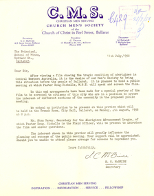
Letter - Correspondence, S.C. McBride, Letter concerning the work of Pastor Doug Nicholls and the Aborigines Advancement League, 1958, 11/07/1958
The Church Men's Society was a part of the Church of Christ in Peel Street, Ballarat. In 1958 the President was C. Thomas, and S.C. McBride was Secretary. The Aborigines Advancement League (also known as the Aboriginal Advancement League) claims to be the oldest Aboriginal organisation in Australia. It is primarily concerned with Aboriginal welfare issues and the preservation of Aboriginal culture and heritage, and is based in Melbourne. The League was established in 1957 as a response to an enquiry by retired magistrate, Charles McLean, into the circumstances of Aboriginal Victorians. McLean was critical of conditions in the Lake Tyers and Framlingham Aboriginal Reserves. McLean recommended that persons of mixed Aboriginal and European descent be removed from the reserves. The people of Lake Tyers objected to this, and the League was formed out of their campaign. The new League drew from two already existing organisations, the Australian Aborigines League, established 1934 and the Save the Aborigines Committee, which had been established in 1955 as a response to the Warburton Ranges crisis. Founding President of the League was Gordon Bryant, with Doris Blackburn as Deputy President, Stan Davey as Secretary and Douglas Nicholls as Field Officer. Early activities included lobbying for a referendum to change the Australian constitution to allow the Federal government to legislate on Aboriginal affairs, and an establishing a legal defence fund for Albert Namatjira, after he was charged with supplying liquor to an Aboriginal ward.[1] By 1967 it had moved to being fully controlled by Aboriginal people with Bill Onus as the first Aboriginal President.Typed letter on Church Men's Society (C.M.S.) letterhead. The letter concerns a film 'showing the tragic condition of aborigines in Central Western Australia ...' The C.M.S. (Ballarat) planned to hold a public meeting in Ballarat at which Pastor Doug Nicholls, M.B.E. will speak and screen the film. doug nicholls, c. thomas, aborigines, ballarat town hall, stan davey, s.c. mcbride, letterhead -
 Federation University Historical Collection
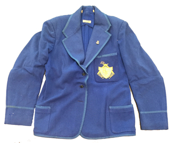
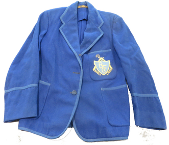
Costume, Ballarat Teachers' College Blazer, 1940s
This blazer was worn by Elaine Cooke when she attended the Ballarat Teachers College. The Ballarat Teachers' College was established after the Victorian State Government and the State Education Department decided to establish two provincial teachers' colleges, at Ballarat and Bendigo. On 04 May 1926 W.H. Ellwood (Principal), Miss A. Bouchier, and Mr A.B. Jones, welcomed the first enrolment of 61 students to undertake the one year course. In 1927 the College moved to the former Ballarat East Town Hall in Barkly Street, which was remodelled for their use. It closed in December 1931 due to the Great Depression. In 1946 Ballarat Teachers' College reopened and relocated to the Dana Street State School. It was originally planned to open as a women's college, for whom the residence at 130 Victoria Street was purchased, but the decision was made to admit resident men from Ballarat. Mr T.W. Turner was appointed as Principal in 1951 and directed the introduction of a two year course for the Trained Primary Teachers' Certificate. The former one year course was terminated at the end of 1951. In 1958 the College was relocated to a custom built facility at Gillies Street, in close proximity to the Ballarat Botanical Gardens. Numbers increased with the introduction of the Trained Infant Teachers' Certificate course under the guidance of Mary Egan. With the introduction of a three year Diploma Course in 1968 accommodation became cramped. The introduction of the Diploma of Teaching (Primary) led to the Trained Infant Teachers' Certificate being discontinued in 1969, and the end of the Trained Primary Teachers' Certificate in 1969. Secondary Art and Craft students began studies at Ballarat Teachers' College in 1969 under Mr Ted Doney. In 1971 Mr D. Watson was appointed Principal. The State College of Victoria was proclaimed by Order in Council on 24 July 1973, and Ballarat Teachers' College became a constituent college of the State College of Victoria, and was known as State College of Victoria, Ballarat. By 1975 the College moved to Mount Helen as part of the Ballarat College of Advanced Education. Pre service teachers currently undertake their studies on the Mount Helen Campus of Federation University. ("Ruffians Attempted to Carry of the School Tent: A History of State Education in Ballarat", 1974, p73-4.)Blue woollen blazer with Ballarat Teachers College lapel pin and embroidered pocket. The edges are bound, including the two side pockets and the breast pocket and the sleeve cuffs have the binding 10.5 cm from the edge. The blazer has three front buttons. The body is unlined but the sleeves are lined with a cotton fabric. The hem edge is bound and hand stitched in place, whilst the back neck facing is cut with pinking shears.Hand written with pen on white tape - E. Cookballarat teachers' college, blazer, elaine cook, costume, textiles, uniform, embroidery -
 Federation University Historical Collection
Costume, Ballarat Teachers' College Blazer, c1947
This blazer was worn by Tom Hill in 1947. He was educated at Digby Primary School and Hammilton High and was appointed principle of Paschendale P.S. and Kannagulk P.S. at the age of 17 before he entered the College at Dana Street. He graduated in 1948 and was appointed to the Myrtle Creek school. At the time of his retirement in 1986 he was principle of Bacchus Marsh P.S. The Ballarat Teachers' College was established after the Victorian State Government and the State Education Department decided to establish two provincial teachers' colleges, at Ballarat and Bendigo. On 04 May 1926 W.H. Ellwood (Principal), Miss A. Bouchier, and Mr A.B. Jones, welcomed the first enrolment of 61 students to undertake the one year course. In 1927 the College moved to the former Ballarat East Town Hall in Barkly Street, which was remodelled for their use. It closed in December 1931 due to the Great Depression. In 1946 Ballarat Teachers' College reopened and relocated to the Dana Street State School. It was originally planned to open as a women's college, for whom the residence at 130 Victoria Street was purchased, but the decision was made to admit resident men from Ballarat. Mr T.W. Turner was appointed as Principal in 1951 and directed the introduction of a two year course for the Trained Primary Teachers' Certificate. The former one year course was terminated at the end of 1951. In 1958 the College was relocated to a custom built facility at Gillies Street, in close proximity to the Ballarat Botanical Gardens. Numbers increased with the introduction of the Trained Infant Teachers' Certificate course under the guidance of Mary Egan. With the introduction of a three year Diploma Course in 1968 accommodation became cramped. The introduction of the Diploma of Teaching (Primary) led to the Trained Infant Teachers' Certificate being discontinued in 1969, and the end of the Trained Primary Teachers' Certificate in 1969. Secondary Art and Craft students began studies at Ballarat Teachers' College in 1969 under Mr Ted Doney. In 1971 Mr D. Watson was appointed Principal. The State College of Victoria was proclaimed by Order in Council on 24 July 1973, and Ballarat Teachers' College became a constituent college of the State College of Victoria, and was known as State College of Victoria, Ballarat. By 1975 the College moved to Mount Helen as part of the Ballarat College of Advanced Education. Pre service teachers currently undertake their studies on the Mount Helen Campus of Federation University. ("Ruffians Attempted to Carry of the School Tent: A History of State Education in Ballarat", 1974, p73-4.)Blue satin lined, wool gabardine Ballarat Teachers' College blazer with embroidered pocket. The jacket has two plain silver coloured buttons at the frontEmbroidered emblem of the Ballarat Teachers College.ballarat teachers' college, blazer, tom hill, thomas hill, costume, uniform, embroidery, textiles -
 Federation University Historical Collection
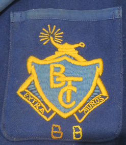
Costume, Paterson Powell Pty Ltd, Ballarat Teachers' College Blazer, 1948
This blazer was worn by John Freckleton at the Ballarat Teachers College in 1949. The Ballarat Teachers' College was established after the Victorian State Government and the State Education Department decided to establish two provincial teachers' colleges, at Ballarat and Bendigo. On 04 May 1926 W.H. Ellwood (Principal), Miss A. Bouchier, and Mr A.B. Jones, welcomed the first enrolment of 61 students to undertake the one year course. In 1927 the College moved to the former Ballarat East Town Hall in Barkly Street, which was remodelled for their use. It closed in December 1931 due to the Great Depression. In 1946 Ballarat Teachers' College reopened and relocated to the Dana Street State School. It was originally planned to open as a women's college, for whom the residence at 130 Victoria Street was purchased, but the decision was made to admit resident men from Ballarat. Mr T.W. Turner was appointed as Principal in 1951 and directed the introduction of a two year course for the Trained Primary Teachers' Certificate. The former one year course was terminated at the end of 1951. In 1958 the College was relocated to a custom built facility at Gillies Street, in close proximity to the Ballarat Botanical Gardens. Numbers increased with the introduction of the Trained Infant Teachers' Certificate course under the guidance of Mary Egan. With the introduction of a three year Diploma Course in 1968 accommodation became cramped. The introduction of the Diploma of Teaching (Primary) led to the Trained Infant Teachers' Certificate being discontinued in 1969, and the end of the Trained Primary Teachers' Certificate in 1969. Secondary Art and Craft students began studies at Ballarat Teachers' College in 1969 under Mr Ted Doney. In 1971 Mr D. Watson was appointed Principal. The State College of Victoria was proclaimed by Order in Council on 24 July 1973, and Ballarat Teachers' College became a constituent college of the State College of Victoria, and was known as State College of Victoria, Ballarat. By 1975 the College moved to Mount Helen as part of the Ballarat College of Advanced Education. Pre service teachers currently undertake their studies on the Mount Helen Campus of Federation University. ("Ruffians Attempted to Carry of the School Tent: A History of State Education in Ballarat", 1974, p73-4.)This unlined, 3 buttoned, royal blue woolen blazer is bound with twill tape in a matching colour. It has a patch pocket on either side near the bottom hem line and a breast patch pocket with an embroidered emblem of the Ballarat Teachers College. Under this emblem is embroidered in stem stitch 'B B' in brown and yellow. The pockets are all bound at the top and the sleeves have a trim binding about 8.5 cm from the cuff. The inside seams are all bound.The fabric label says - Paterson, Powell Pty Ltd Ballarat Attached to the shoulder seam is a tape with a handwritten - Georgeballarat teachers' college, blazer, costume, textiles, uniform, embroidery -
 Federation University Historical Collection
Book, Victoria Planning and Environment Act, 1987, 1987
This copy of the Planning and Environment Act was used by Creswick Engineer Brian SchreenanGreen soft covered book. A first edition Victorian Planning and Environment Act.plannning, environment, town planning, planning and environment act, victorian act of parliament, acts 1987 no. 45, brian schreenan -
 Federation University Historical Collection
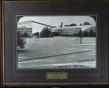
Photograph - Photographs - Black and White, Ballarat Teachers' College
These images were hung in the corridor of the University of Ballarat School of Education (Mount Helen). It most probably dates from around the time of the transfer of the College. The Ballarat Teachers' College was established after the Victorian State Government and the State Education Department decided to establish two provincial teachers' colleges, at Ballarat and Bendigo. On 04 May 1926 W.H. Ellwood (Principal), Miss A. Bouchier, and Mr A.B. Jones, welcomed the first enrolment of 61 students to undertake the one year course. In 1927 the College moved to the former Ballarat East Town Hall in Barkly Street, which was remodelled for their use. It closed in December 1931 due to the Great Depression. In 1946 Ballarat Teachers' College reopened and relocated to the Dana Street State School. The building used by the Teachers' College was the original bluestone building facing Doveton Street South. It was originally planned to open as a women's college, for whom the residence at 130 Victoria Street was purchased, but the decision was made to admit resident men from Ballarat. Mr T.W. Turner was appointed as Principal in 1951 and directed the introduction of a two year course for the Trained Primary Teachers' Certificate. The former one year course was terminated at the end of 1951. In 1958 the College was relocated to a custom built facility at Gillies Street, in close proximity to the Ballarat Botanical Gardens. Numbers increased with the introduction of the Trained Infant Teachers' Certificate course under the guidance of Mary Egan. With the introduction of a three year Diploma Course in 1968 accommodation became cramped. The introduction of the Diploma of Teaching (Primary) led to the Trained Infant Teachers' Certificate being discontinued in 1969, and the end of the Trained Primary Teachers' Certificate in 1969. Secondary Art and Craft students began studies at Ballarat Teachers' College in 1969 under Mr Ted Doney. In 1971 Mr D. Watson was appointed Principal. The State College of Victoria was proclaimed by Order in Council on 24 July 1973, and Ballarat Teachers' College became a constituent college of the State College of Victoria, and was known as State College of Victoria, Ballarat. By 1975 the College moved to Mount Helen as part of the Ballarat College of Advanced Education. Pre service teachers currently undertake their studies on the Mount Helen Campus of Federation University. ("Ruffians Attempted to Carry of the School Tent: A History of State Education in Ballarat", 1974, p73-4.)Three photographs of the Ballarat Teachers' College, all at different locaitons. .1) Dana Street Primary School (State School) .2) Barkly Street - former Ballarat East Town Hall .3) Gillies StreetBrass plaque on each framed photograph .1) Ballarat Teachers' College Doveton Street 1926, 1946-1957 (Part of Dana Street Primary School No. 33) .2) Ballarat Teachers' College Barkly Street 1927-1931 (Formerly Ballarat East Town Hall) .3) Ballarat Teachers' College State College of Victoria at Ballarat Gillies Street 1958-1976ballarat teachers' college, dana street primary school, ballarat east library, gillies street, state college of victoria, state college of victoria at ballarat -
 Federation University Historical Collection
Costume - Blazer, Ballarat Teachers' College Blazer, c1954
Wilma Hall (later Hobbs) wore this blazer while studying at the Ballarat Teachers' College in 1954-55. The college was established after the Victorian State Government and the State Education Department decided to establish two provincial teachers' colleges, at Ballarat and Bendigo. On 04 May 1926 W.H. Ellwood (Principal), Miss A. Bouchier, and Mr A.B. Jones, welcomed the first enrolment of 61 students to undertake the one year course. In 1927 the College moved to the former Ballarat East Town Hall in Barkly Street, which was remodelled for their use. It closed in December 1931 due to the Great Depression. In 1946 Ballarat Teachers' College reopened and relocated to the Dana Street State School. It was originally planned to open as a women's college, for whom the residence at 130 Victoria Street was purchased, but the decision was made to admit resident men from Ballarat. Mr T.W. Turner was appointed as Principal in 1951 and directed the introduction of a two year course for the Trained Primary Teachers' Certificate. The former one year course was terminated at the end of 1951. In 1958 the College was relocated to a custom built facility at Gillies Street, in close proximity to the Ballarat Botanical Gardens. Numbers increased with the introduction of the Trained Infant Teachers' Certificate course under the guidance of Mary Egan. With the introduction of a three year Diploma Course in 1968 accommodation became cramped. The introduction of the Diploma of Teaching (Primary) led to the Trained Infant Teachers' Certificate being discontinued in 1969, and the end of the Trained Primary Teachers' Certificate in 1969. Secondary Art and Craft students began studies at Ballarat Teachers' College in 1969 under Mr Ted Doney. In 1971 Mr D. Watson was appointed Principal. The State College of Victoria was proclaimed by Order in Council on 24 July 1973, and Ballarat Teachers' College became a constituent college of the State College of Victoria, and was known as State College of Victoria, Ballarat. By 1975 the College moved to Mount Helen as part of the Ballarat College of Advanced Education. Pre service teachers currently undertake their studies on the Mount Helen Campus of Federation University. ("Ruffians Attempted to Carry off the School Tent: A History of State Education in Ballarat", 1974, p73-4.)Blue unlined, woollen Ballarat Teachers' College blazer with embroidered pocket. The jacket had three buttons at the front although two are missing. The edges are all bound with tape including the pocket and the sleeve binding is 12cm from the cuff edge. The seam edges are either turned back and stitched or cut with pinking shears. There is a small panel on either side of the inside between the side seam and the facing which reinforces the pockets.Embroidered emblem of the Ballarat Teachers College and woven makers patch - The Myer Store for Menballarat teachers' college, blazer, wilma hall, wilma hobbs, textiles, costume, embroidery, uniform -
 Federation University Historical Collection
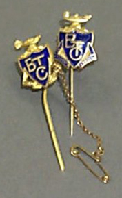
Stick Pin, Swann, Ballarat Teachers' College Stick Pins, c1948/50
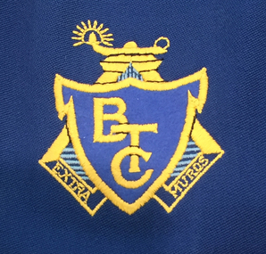
Both this students stick pin and Ex Students' Association stick pin were owned and worn by Helen Veitch who was a student at the Ballarat Teachers' College in 1948. The Ballarat Teachers' College was established after the Victorian State Government and the State Education Department decided to establish two provincial teachers' colleges, at Ballarat and Bendigo. On 04 May 1926 W.H. Ellwood (Principal), Miss A. Bouchier, and Mr A.B. Jones, welcomed the first enrolment of 61 students to undertake the one year course. In 1927 the College moved to the former Ballarat East Town Hall in Barkly Street, which was remodelled for their use. It closed in December 1931 due to the Great Depression. In 1946 Ballarat Teachers' College reopened and relocated to the Dana Street State School. It was originally planned to open as a women's college, for whom the residence at 130 Victoria Street was purchased, but the decision was made to admit resident men from Ballarat. Mr T.W. Turner was appointed as Principal in 1951 and directed the introduction of a two year course for the Trained Primary Teachers' Certificate. The former one year course was terminated at the end of 1951. In 1958 the College was relocated to a custom built facility at Gillies Street, in close proximity to the Ballarat Botanical Gardens. Numbers increased with the introduction of the Trained Infant Teachers' Certificate course under the guidance of Mary Egan. With the introduction of a three year Diploma Course in 1968 accommodation became cramped. The introduction of the Diploma of Teaching (Primary) led to the Trained Infant Teachers' Certificate being discontinued in 1969, and the end of the Trained Primary Teachers' Certificate in 1969. Secondary Art and Craft students began studies at Ballarat Teachers' College in 1969 under Mr Ted Doney. In 1971 Mr D. Watson was appointed Principal. The State College of Victoria was proclaimed by Order in Council on 24 July 1973, and Ballarat Teachers' College became a constituent college of the State College of Victoria, and was known as State College of Victoria, Ballarat. By 1975 the College moved to Mount Helen as part of the Ballarat College of Advanced Education. Pre service teachers currently undertake their studies on the Mount Helen Campus of Federation University. ("Ruffians Attempted to Carry of the School Tent: A History of State Education in Ballarat", 1974, p73-4.)Two gold coloured stick pins with the Ballarat Teachers' College Shield, featuring a blue enamelled background with the letters in gold. 1). has Ex Students Assoc'n in gold with blue enamelled background at the bottom of the shield. 2). has Extra Muros in gold coloured relief at the bottom of the shield and a safety chain and pin attached.BTC shield ballarat teachers' college, stick pin, student stick pin, ex student association stick pin, helen veitch -
 Federation University Historical Collection
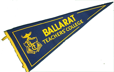
Pennant, Ballarat Teachers' College, c1948
The pennant was part of the collection owned by Helen Veitch when she was a student at the Ballarat Teachers' College in 1948. The Ballarat Teachers' College was established after the Victorian State Government and the State Education Department decided to establish two provincial teachers' colleges, at Ballarat and Bendigo. On 04 May 1926 W.H. Ellwood (Principal), Miss A. Bouchier, and Mr A.B. Jones, welcomed the first enrolment of 61 students to undertake the one year course. In 1927 the College moved to the former Ballarat East Town Hall in Barkly Street, which was remodelled for their use. It closed in December 1931 due to the Great Depression. In 1946 Ballarat Teachers' College reopened and relocated to the Dana Street State School. It was originally planned to open as a women's college, for whom the residence at 130 Victoria Street was purchased, but the decision was made to admit resident men from Ballarat. Mr T.W. Turner was appointed as Principal in 1951 and directed the introduction of a two year course for the Trained Primary Teachers' Certificate. The former one year course was terminated at the end of 1951. In 1958 the College was relocated to a custom built facility at Gillies Street, in close proximity to the Ballarat Botanical Gardens. Numbers increased with the introduction of the Trained Infant Teachers' Certificate course under the guidance of Mary Egan. With the introduction of a three year Diploma Course in 1968 accommodation became cramped. The introduction of the Diploma of Teaching (Primary) led to the Trained Infant Teachers' Certificate being discontinued in 1969, and the end of the Trained Primary Teachers' Certificate in 1969. Secondary Art and Craft students began studies at Ballarat Teachers' College in 1969 under Mr Ted Doney. In 1971 Mr D. Watson was appointed Principal. The State College of Victoria was proclaimed by Order in Council on 24 July 1973, and Ballarat Teachers' College became a constituent college of the State College of Victoria, and was known as State College of Victoria, Ballarat. By 1975 the College moved to Mount Helen as part of the Ballarat College of Advanced Education. Pre service teachers currently undertake their studies on the Mount Helen Campus of Federation University. ("Ruffians Attempted to Carry of the School Tent: A History of State Education in Ballarat", 1974, p73-4.)lBlue wool felt pennant with a yellow felt edge with 2 loops stitched to the side edge. The pennant is printed in yellow with the words 'Ballarat Teachers' College' and Coat of Arms.Printed - Ballarat Teachers' College & Coat of Armsballarat teachers' college, pennant, helen veitch -
Federation University Historical Collection
Booklet, Ballarat Teachers' College Song Book, c1947
Students at the Ballarat Teachers' College would sing the songs in the songbook regularly. The Ballarat Teachers' College was established after the Victorian State Government and the State Education Department decided to establish two provincial teachers' colleges, at Ballarat and Bendigo. On 04 May 1926 W.H. Ellwood (Principal), Miss A. Bouchier, and Mr A.B. Jones, welcomed the first enrolment of 61 students to undertake the one year course. In 1927 the College moved to the former Ballarat East Town Hall in Barkly Street, which was remodelled for their use. It closed in December 1931 due to the Great Depression. In 1946 Ballarat Teachers' College reopened and relocated to the Dana Street State School. The building used by the Teachers' College was the original bluestone building facing Doveton Street South. It was originally planned to open as a women's college, for whom the residence at 130 Victoria Street was purchased, but the decision was made to admit resident men from Ballarat. Mr T.W. Turner was appointed as Principal in 1951 and directed the introduction of a two year course for the Trained Primary Teachers' Certificate. The former one year course was terminated at the end of 1951. In 1958 the College was relocated to a custom built facility at Gillies Street, in close proximity to the Ballarat Botanical Gardens. Numbers increased with the introduction of the Trained Infant Teachers' Certificate course under the guidance of Mary Egan. With the introduction of a three year Diploma Course in 1968 accommodation became cramped. The introduction of the Diploma of Teaching (Primary) led to the Trained Infant Teachers' Certificate being discontinued in 1969, and the end of the Trained Primary Teachers' Certificate in 1969. Secondary Art and Craft students began studies at Ballarat Teachers' College in 1969 under Mr Ted Doney. In 1971 Mr D. Watson was appointed Principal. The State College of Victoria was proclaimed by Order in Council on 24 July 1973, and Ballarat Teachers' College became a constituent college of the State College of Victoria, and was known as State College of Victoria, Ballarat. By 1975 the College moved to Mount Helen as part of the Ballarat College of Advanced Education. Pre service teachers currently undertake their studies on the Mount Helen Campus of Federation University. ("Ruffians Attempted to Carry of the School Tent: A History of State Education in Ballarat", 1974, p73-4.) 1 blue covered Ballarat Teachers' College Books. Includes a photograph of Monica Millar in the front inside cover. Inside front cover 'Monica Miller' autographs in inside book pages from the reunion on 1. 9. 1960 of BTC 1930ballarat teachers college, monica miller, extra muros, w h ellwood, entertainment, ellwood, w.h. ellwood, ballarat teachers' college -
 Federation University Historical Collection
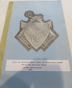
Music Book, Music for the Ballarat Teachers' College Anthem 'Extra Muros', 1994, 1994
Monica Miller was a greatly loved music lecturer at the Ballarat Teachers' College lecturer Monica Miller. The Ballarat Teachers' College was established after the Victorian State Government and the State Education Department decided to establish two provincial teachers' colleges, at Ballarat and Bendigo. On 04 May 1926 W.H. Ellwood (Principal), Miss A. Bouchier, and Mr A.B. Jones, welcomed the first enrolment of 61 students to undertake the one year course. In 1927 the College moved to the former Ballarat East Town Hall in Barkly Street, which was remodelled for their use. It closed in December 1931 due to the Great Depression. In 1946 Ballarat Teachers' College reopened and relocated to the Dana Street State School. It was originally planned to open as a women's college, for whom the residence at 130 Victoria Street was purchased, but the decision was made to admit resident men from Ballarat. Mr T.W. Turner was appointed as Principal in 1951 and directed the introduction of a two year course for the Trained Primary Teachers' Certificate. The former one year course was terminated at the end of 1951. In 1958 the College was relocated to a custom built facility at Gillies Street, in close proximity to the Ballarat Botanical Gardens. Numbers increased with the introduction of the Trained Infant Teachers' Certificate course under the guidance of Mary Egan. With the introduction of a three year Diploma Course in 1968 accommodation became cramped. The introduction of the Diploma of Teaching (Primary) led to the Trained Infant Teachers' Certificate being discontinued in 1969, and the end of the Trained Primary Teachers' Certificate in 1969. Secondary Art and Craft students began studies at Ballarat Teachers' College in 1969 under Mr Ted Doney. In 1971 Mr D. Watson was appointed Principal. The State College of Victoria was proclaimed by Order in Council on 24 July 1973, and Ballarat Teachers' College became a constituent college of the State College of Victoria, and was known as State College of Victoria, Ballarat. By 1975 the College moved to Mount Helen as part of the Ballarat College of Advanced Education. Pre service teachers currently undertake their studies on the Mount Helen Campus of Federation University. ("Ruffians Attempted to Carry of the School Tent: A History of State Education in Ballarat", 1974, p73-4.) A copy of hand written sheet music for the song 'Extra Muros' by Ballarat Teachers' College lecturer Monica Miller. Copy of Monica's sheet music of anthem 'Extra Muros'. Gift of teh Rawlings Family to the Fortyniners. 1994. ballarat, ballarat teachers college, monica miller, extra muros, music, sheet music, ballarat teachers' college -
 Federation University Historical Collection
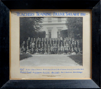
Photograph, Teachers' Training College Ballarat, 1930
The Ballarat Teachers' College was established after the Victorian State Government and the State Education Department decided to establish two provincial teachers' colleges, at Ballarat and Bendigo. On 04 May 1926 W.H. Ellwood (Principal), Miss A. Bouchier, and Mr A.B. Jones, welcomed the first enrolment of 61 students to undertake the one year course. In 1927 the College moved to the former Ballarat East Town Hall in Barkly Street, which was remodelled for their use. It closed in December 1931 due to the Great Depression. In 1946 Ballarat Teachers' College reopened and relocated to the Dana Street State School. The building used by the Teachers' College was the original bluestone building facing Doveton Street South. It was originally planned to open as a women's college, for whom the residence at 130 Victoria Street was purchased, but the decision was made to admit resident men from Ballarat. Mr T.W. Turner was appointed as Principal in 1951 and directed the introduction of a two year course for the Trained Primary Teachers' Certificate. The former one year course was terminated at the end of 1951. In 1958 the College was relocated to a custom built facility at Gillies Street, in close proximity to the Ballarat Botanical Gardens. Numbers increased with the introduction of the Trained Infant Teachers' Certificate course under the guidance of Mary Egan. With the introduction of a three year Diploma Course in 1968 accommodation became cramped. The introduction of the Diploma of Teaching (Primary) led to the Trained Infant Teachers' Certificate being discontinued in 1969, and the end of the Trained Primary Teachers' Certificate in 1969. Secondary Art and Craft students began studies at Ballarat Teachers' College in 1969 under Mr Ted Doney. In 1971 Mr D. Watson was appointed Principal. The State College of Victoria was proclaimed by Order in Council on 24 July 1973, and Ballarat Teachers' College became a constituent college of the State College of Victoria, and was known as State College of Victoria, Ballarat. By 1975 the College moved to Mount Helen as part of the Ballarat College of Advanced Education. Pre service teachers currently undertake their studies on the Mount Helen Campus of Federation University. ("Ruffians Attempted to Carry of the School Tent: A History of State Education in Ballarat", 1974, p73-4.)Framed photograph of the staff and students of the Ballarat Teachers' College taken outside the outside of the Ballarat East Town Hall. teachers training college ballarat, ballarat teachers' college, w.h. ellwood, a.b. jones, a.r. hamono, monica miller, a.j. colo, n. larkin, k. henderson, v. mckenzie, prudence hamono, ballarat east library, ballarat east town hall, r.g. bowman, univesity women -
 Bendigo Historical Society Inc.
Document - NORMAN OLIVER COLLECTION: MAYOR'S NOTES 1964
The Norman Oliver collection. Norman Oliver was three times Mayor of Bendigo - 1950-51, 1964-65, 1970-71. 1. Two covering pages, with handwriting in blue pen. Mayor's Notes 1964, and Contents of File - Mayor's Notes 1964, Bendigo, Local Government, Town Planning, Water - Coliban Area, Business - marketing, etc., Speech for Graduation of Nurses. 2. Four typed pages of undated Mayor's Notes which make reference to the first week as Mayor, and learning of his appointment on 29 August. Topics include : a council business meeting dealing with the use of the Garden Gully sports facilities, the Housing Commission garden competition, Royal Commission on supply and consumption of liquor, neighbourhood disputes regarding drainage issues and owner responsibility, Rotary Club slide presentation on Bendigo past and present, tenders to Council for supply of a range of materials, Art Gallery Committee meeting (noting the need for careful selection policy re. donations and borrowings).bendigo, council, speech notes, norman joseph oliver , councillor norman oliver. mayor of bendigo. bendigo art gallery. rotary clubs - bendigo. royal commission on supply and consumption of liquor. -
 Bendigo Historical Society Inc.
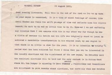
Document - NORMAN OLIVER COLLECTION: SPEECH NOTES 22 AUGUST 1951
The Norman Oliver collection. Norman Oliver was three times Mayor of Bendigo - 1950-51, 1964-65, 1970-71. Sixteen pages of typed notes headed Mayoral Report 22 August 1951. Corrections in blue ink. In the format he used for his talks on 3BO 'The Mayor Speaks'. The last report for his first Mayoral term. Topics include : the Year's work - land reclamation, the loan for earth moving plant, garbage disposal, sports grounds, drainage, Sewerage Authority, the saleyards, the Aerodrome, Housing, and the Bendigo Creek and town planning.bendigo, council, speech notes, norman joseph oliver , councillor norman oliver. mayor of bendigo. 3bo 'the mayor speaks'. -
 Bendigo Historical Society Inc.
Document - NORMAN OLIVER COLLECTION: SPEECH NOTES FOR MAYOR'S INAUGURATION 1950
The Norman Oliver collection. Norman Oliver was three times Mayor of Bendigo - 1950-51, 1964-65, 1970-71. Five typed foolscap pages for his first mayoral speech. Mentions Bendigo Centenary celebrations for the following year, so speech would have been delivered in 1950. In the speech, Oliver emphasises the importance of town planning.bendigo, council, speech notes, norman joseph oliver , councillor norman oliver. mayor of bendigo. bendigo centenary 1951. -
Port Melbourne Historical & Preservation Society
Document - Community Service Planning, Beris Campbell Collection, 1974 - 1993
Collection of files from Beris CAMPBELL; Port's first Social Worker. Includes local newspapers, flyers and reportsCommunity Service Planning 1992local government - city of port melbourne, health - general health, politics, public action campaigns, port melbourne citizens action group, port melbourne social welfare centre, city of south melbourne, beris campbell -
Port Melbourne Historical & Preservation Society
Document - City of Port and City of South Melbourne, Community Services forward plan, Beris Campbell Collection, 1974 - 1993
Collection of files from Beris CAMPBELL; Port's first Social Worker. Includes local newspapers, flyers and reportsCity of Port Melbourne and City of South Melbourne. Community Services forward plan 1986local government - city of port melbourne, health - general health, politics, public action campaigns, port melbourne citizens action group, port melbourne social welfare centre, city of south melbourne, beris campbell -
Port Melbourne Historical & Preservation Society
Plan, John James Wild, Architect, New Town Hall Sandridge 1881, 1 Jan 1881
Laminated copy from City collection, elevation plans for new Town Hall Sandridge 1881. .01 - front elevation .02 - rear elevation .03 - transverse section .04 - ground floor plan - A3 copy .05 - first floor plan - A3 copyarchitecture, port melbourne town hall, town clerks, built environment - civic, sandridge town hall, john james wild, edward clark -
Port Melbourne Historical & Preservation Society
Document, "Plan of Town of Melbourne 1837 A.D.", 1937
Photocopy of "Plan of Town of Melbourne 1837 A.D." Also showing first land sales, historical memoranda, and an alphabetical list of purchases.town planning, town of melbourne -
Port Melbourne Historical & Preservation Society
Plan - Alternative Layouts for Fishermans Bend, J C Morrell, Jun 1920
Published 1920 by PMCC but first presented at the 1st Australian Town Planning Conference, Adelaide 1917.Two alternative plans for Fishermen's Bend, proposing harbour improvements and layout of suburbs and industrial areas. First presented 1917.fishermans bend, town planning - proposals shelved, j c morrell -
Port Melbourne Historical & Preservation Society
Plan - Proposed Alterations, Port Melbourne Town Hall, B S Elms & Co Pty Ltd, 23 Jun 1966
From a set of two drawings, 1966 - plans - details of alterations to Council Chamber, Councillors Room and first floor of Town Hall - not proceeded with. port melbourne town hall -
Port Melbourne Historical & Preservation Society
Plan - Proposed Alterations, Port Melbourne Town Hall, B S Elms & Co Pty Ltd, 23 Jun 1966
Drawing from a set of two, 1966 - Plans - details of alterations to Town Hall - not proceeded with. Details of Council Chamber, Councillors Room and first floor of Town Hall, hand coloured and material samples attachedport melbourne town hall -
Port Melbourne Historical & Preservation Society
Plan - WWII alterations to Excelsior Hall, Port Melbourne, City Engineer, 13 Apr 1942
Plan on tracing paper for Excelsior Hall to be set up as a first-aid post (in the event of gas attack) and A.R.P. training centre in World War II. 1942."City of Port Melbourne : Excelsior Hall"war - world war ii, built environment - civic, excelsior hall, engineering department - city of port melbourne -
Port Melbourne Historical & Preservation Society
Plan - Port Melbourne Town Hall, Engineering Department, Town of Port Melbourne, 1915
Plan of new (1915) Town Hall, Port Melbourne Foundation Plan, ground floor plan; first floor planport melbourne town hall -
Port Melbourne Historical & Preservation Society
Plan - Seamen's Mission, Harry Norris, Blueprints, 1980s
Plans copied by Brian Couldrey when he was running the Mission Arts Centre in the building (1987 -1991).Photocopies (12) of blueprints of Plans for 1937 Seamen's Mission, by Harry Norris, in A4 sections - Ground floor - sheets f - l and First floor sheets a - e.architecture, missions to seamen, harry a norris -
Port Melbourne Historical & Preservation Society
Card - PMHPS Registration Card No 1, Margaret Bride, 30 Aug 1994
Museums Australia had given PMHPS volunteers a workshop instructing on catalogue procedure. PMHPS was working in the disused classrooms of the former St Josephs Primary. The plans were the first items catalogued.Registration card No1: Plan of Edwards Park, being the first item catalogued by volunteers of the PMH&PS 30 August 1994.societies clubs unions and other organisations, port melbourne historical & preservation society, pmhps, margaret bride nee polson, edwards park -
Port Melbourne Historical & Preservation Society
Pamphlet - Brochure, cabin plan, P&O Orient Lines - SS Canberra, Sep 1964
Probably with materials from Station Pier kiosk, donated by Ted RohanPlan of first class accommodation on the P&O Orient liner Canberratransport - shipping, canberra, p&o lines