Showing 44 items
matching fish creek
-
 Eltham District Historical Society Inc
Book, Jenny Brown et al, Out of the Mist; Osborne Peninsula, 2024
The Osborne Peninsula on the Yarra River at Warrandyte accommodates a limited number of properties and residents (70 households). The area is rich in geology and ecology, and an unusually rich endowment of human, built and creative history. Contents: Welcome: The landform: The River: Aboriginal occupation: The Miners: North Warrandyte :The Subdivision: The Lowes: The Osbornes: The Last Osborne: The Elders: The Relics: Dray Track: Water Wheel"Kauri Plaque: River track: Pines: Windmill Creek Bridge: The Koornong School: The Houses" Man Cave: MidCentury Classic: Enduring Original" Masterwork: The Muddies: The State Park: The Saving of Koornong Reserve: The Landcare Story: Flora and Fauna: The Vulnerable, Endangered and threatened: Birds: Mammals: "Waring" the wombat: Reptiles: Fish: Invertebrates: Flora: Fire. Published by the North Warrandyte (Osborne Peninsula) Landcare Group. Includes photos from EDHS collection.64 p. : ill., map ; 29.7 x 21 cm. (2 copies)yarra river, birrarung, dray track, fauna, geology, houses, indigenous history, koornong reserve, koornong school, lowe family, mining, mudbrick houses, north warrandyte, osborne family, warrandyte state park, water wheel, north warrandyte (osborne peninsula) landcare group, osborne peninsula -
 Lakes Entrance Historical Society
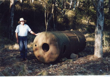
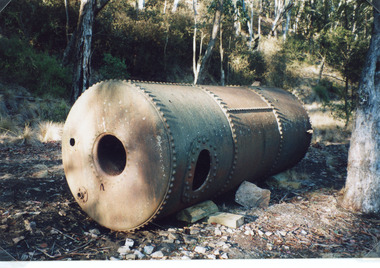
Photograph - Tramline, Fish Marie, 1977
Date made 18 January 1977.Colour photograph of Rex Fish standing beside the boiler which provided steam power to drive the winch to transfer rock from the tram, trucks to the barge at North Arm. This rock quarried at Mississippi Creek was used to stabilise the entrance piers, and build rock groynes around the lakes. Lakes Entrance Victoria waterways, historic sites, public works, machinery -
 Lakes Entrance Historical Society
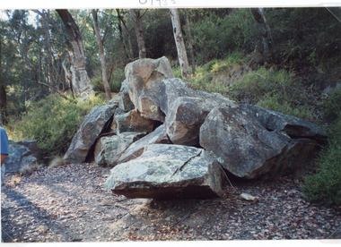
Photograph - Tramline, Fish Marie, 1997
Date made 18 January 1997Colour photograph of a pile of granite rock left on the bank of the North Arm. This rock was quarried at Mississippi Creek and conveyed by tramline to the North Arm where it was loaded on barges and conveyed to the entrance where it was used to stabilise the piers. Lakes Entrance Victoria waterways, public works, quarries -
 Lakes Entrance Historical Society
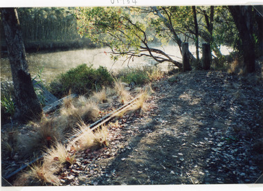
Photograph - Tramline, Fish Marie, 1997
Date made 18 January 1997Colour photograph of a remnant of the tramway which ran from the Mississippi Creek quarry to the head of the North Arm. It shows two lengths of discarded iron rail on the bank of the creek. Lakes Entrance Victoriawaterways, public works, transport, historic site -
 Lakes Entrance Historical Society
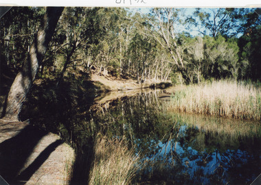
Photograph - Mississippi Creek Landing, Fish Marie, 1997
... Mississippi Creek Landing Fish Marie ...Date made 18 January 1997Color photograph of Mississippi Creek at the head of the North Arm. It shows natural vegetation on the banks of the creek, which is reflected in the calm waters. Lakes Entrance Victoria waterways, transport -
 Lakes Entrance Historical Society
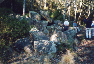
Photograph - Tramline, 1977
One of persons named Rex Fish.Colour photograph of a large pile of granite rock left on the bank of the North Arm. This rock was quarried at Mississippi Creek and conveyed by tramline to the North Arm where it was loaded into barges and conveyed to the entrance for stabilising the piers. Four people in photo. Lakes Entrance Victoria public works, quarries, historic site -
 Lakes Entrance Historical Society
Photograph - Tramline, Fish Marie, 1997
Date made 18 January 1997Colour photograph of a boiler which provided steam power to drive a winch at North Arm. Rock was transported from Mississippi Creek quarry along a tramline to North Arm where rock was transferred by steam powered winch to a barge which carried rock to the entrance. Lakes Entrance Victoriahistoric site, machinery -
 Lakes Entrance Historical Society
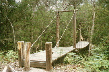
Photograph - Bridges, Fish Marie, 1995
Colour photograph of the suspension bridge at Mississippi Creek picnic area in Colquhoun State Forest near Lakes Entrance, Victoriabridges, vegetation -
 Lakes Entrance Historical Society
Book, Hawkins Richard, Creeks and Harbours of the Gippsland Lakes and East Gippsland, 1989
A comprehensive boating guide to the Gippsland Lakes, Lake Tyers, Marlo, Bemm River, Sydenham, Tamboon and Mallacoota Inlets, includes short list of bird life and fish species, and description of towns bordering the waterways.waterways, boats and boating -
 The Beechworth Burke Museum
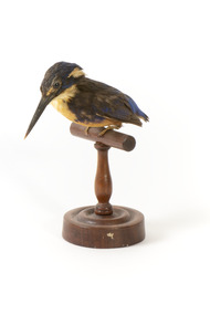
Animal specimen - Azure kingfisher, Trustees of the Australian Museum, 1860-1880
The Azure kingfisher can be located throughout northern and eastern Australia. It can also been found in parts of Indonesia, New Guinea and surrounding islands. This species frequents the Kimberley region in Western Australia and and the Top End of Queensland. In Victoria, it resides inland near the Murray-Darling Basin. These birds prefer to make their homes near bodies of water such as creeks and rivers. They live in areas with shady vegetation. This particular species of Kingfisher are known for their bright and contrasting colouring and tiny stature. They are the smallest kingfisher found in Australia. These birds feed on yabbies and small fish. This specimen is part of a collection of almost 200 animal specimens that were originally acquired as skins from various institutions across Australia, including the Australian Museum in Sydney and the National Museum of Victoria (known as Museums Victoria since 1983), as well as individuals such as amateur anthropologist Reynell Eveleigh Johns between 1860-1880. These skins were then mounted by members of the Burke Museum Committee and put-on display in the formal space of the Museum’s original exhibition hall where they continue to be on display. This display of taxidermy mounts initially served to instruct visitors to the Burke Museum of the natural world around them, today it serves as an insight into the collecting habits of the 19th century.This specimen is part of a significant and rare taxidermy mount collection in the Burke Museum. This collection is scientifically and culturally important for reminding us of how science continues to shape our understanding of the modern world. They demonstrate a capacity to hold evidence of how Australia’s fauna history existed in the past and are potentially important for future environmental research. This collection continues to be on display in the Museum and has become a key part to interpreting the collecting habits of the 19th century.The Azure kingfisher is stylised perched upon a wooden stand and has a paper identification tag attached to one of its legs. This bird has a combination of blue, yellow/orange and black plumage. The orange colour is located upon its chest while the royal blue is upon the rear of the bird on its back and head. The blue has faded in places due to age. The specimen is a diminutive bird species with a wide torso and a long and slender black bill. It has a short tail and two glass black eyes. The feet are a pale cream colour.11a. / Azure Kingfisher See Catalogue, page 9. /taxidermy mount, taxidermy, animalia, burke museum, beechworth, australian museum, skin, reynell eveleigh johns, bird, australian birds, kingfisher, azure, azure kingfisher, small birds, brightly coloured birds -
Lakes Entrance Historical Society
Photograph - Post card Rose series 3643 Warburton, Rose Stereographers Armadale Victoria, 1920 - 30 c
The writer of the message on back of card was a Miss Ruth Catt who boarded with the family of Vic and Myrtle Fish of Roadknight St Lakes Entrance in the 1920 - 30 She was a teacher at the Bunga Creek State School East of Lakes Entrance and walked through the bush to schoolSepia toned postcard showing white wooden bridge over Yarra River with hill at back densely wooded shrubbery along river bank and rocky foreground at Warburton VictoriaThe Rose Series P3643 The Beautiful Yarra Warburton Victoriaschool teachers -
Lakes Entrance Historical Society
Photograph - Wooden Bridge Martins Creek, Marie Fish, 1990 c
... Wooden Bridge Martins Creek Marie Fish ...Colour photograph of wooden bridge over Martins Creek on Bonang Highway East Gippsland Victoriabridges -
Lakes Entrance Historical Society
Photograph - Scene at Buggy Creek, M Fish, 1/05/1993 12:00:00 AM
... of Buchan South Victoria Photograph Scene at Buggy Creek M Fish ...Black and white photograph of an old corner post showing mortices to take fence rail at Buggy Creek south of Buchan South Victoria agriculture -
 Lakes Entrance Historical Society
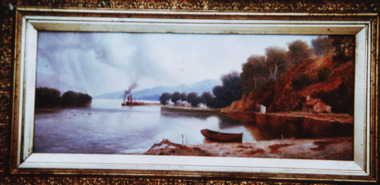
Photograph - Scene from Kalimna Jetty, Fish M, 1900 c
Coloured photograph of original oil painting by Walter Seahusan scene from Kalimna jetty looking west toward Maringa Creek and showing mill workers cottages wharf barge at Maringa creek and fishermans cottages on right Lakes Entrance Victoria jetties, waterways, painting