Showing 36 items matching "fluming"
-
 Stawell Historical Society Inc
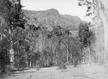
Photograph, Grampians at Halls Gap 1866
Grampians Halls Gap. Part of a collection of Photographs by Mr. O.G. Armstrong as commissioned by the Shire of Stawell for the Inter-colonial and Paris Exhibition in Melbourne in 1866. From about 1860 there was agitation for a water supply, not only for Stawell but for the Wimmer Mallee as well. In 1887 Wartook was adopted as the first reservoir for the Wimmer. Stawells water supply was designed by Mr. John D’Alton. The scheme came from Fyan’s Creek via Wooden Fluming and a Syphon and finally through the mountain in a tunnel, before being piped to a reservoir on Big Hill. The system was completed in December 1881 and although there have been modifications, basically it has not been changed to this day. The Wimmera Mallee stock and domestic system from the Grampians is the largest system of its kind in the world, the latest edition being like Belfield and piping of Wimmera channels. stawell -
 Stawell Historical Society Inc
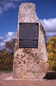
Slide, Ian McCann, Monuments Cnetenaryy of Water Supply
Momument to commemorate the Centenary of the Stawell Water Supply as designed by Mr. John D'AltonTown of Stawell Erreceted to Commemorate the the Centenary of Stawell's Water Supply System. As Designed by John D'Alton, his sceme included the diversion of Water from Fyan's Creek in the Grampians to Stawell a distance of 35 km. And involved the costruction of Timber Fluming Mountain Tunnel 300 mm Pipeline 100 years later the principle of the scheme remains the same. Work Commenced Feburary 1875 and was completed December 1881. Unveiled by The Hon. F.J. Cranter M.L.C. Minister for Water Supply On Novemebr 15th 1975 Cr. M.K. Hallam J.P. Mayordoctor's hill, hospital -
 Bendigo Historical Society Inc.
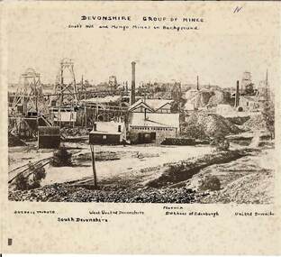
Photograph - DEVONSHIRE GROUP OF MINES,1896
Black and white photograph on cream card.Foxing spots throughout. Date approx. 1896 / 1876. View across mining area showing at least 9 poppet heads, 11 chimneys and many buildings associated with the mines. C to L - flume, wood stacks, mullock heaps. Inscriptions in image: 'Duchess Tribute' on weather board building at C. 'N' at TR. Hand printed above image (on earlieir copy of this image of which this is a photograph), 'Devonshire Group on Mines / Snob's Hill and Mungo Mines in Background'. Above image: 'Duchess Tribute', 'South Devonshire', 'West United Devonshire', 'Pheonix', 'Duchess of Edinburgh', 'United Devonshire'. On the back: blue circular stamp 'Royal Historical Society of Victoria, Bendigo Branch' , 'MNG 71'.James Lerk 26/11/1999place, mining site, see also 2000.426.01, 2000.437.01, 2000.438.01, 2000.439.01, 2000.504.01, 2000.508.01, 2000.509.01 -
 Federation University Historical Collection
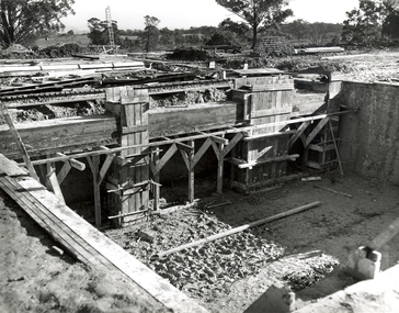
Photograph, N.l. Harvey & Son, Mount Helen Campus, 1968, 1969
The Federation University campus at Mount Helen was first used by students in 1970.Seven photographs of the Mt Helen Campus Stage one development. .1) Aerial view of foundation work, from west, towards Green Hill .2) Aerial View from South. Earthworks and foundations .3) Aerial View from south west. Earthworks, general view .4) Aerial View from above the South West corner of E building. .5) Aerial View from North East. Gear Avenue in background .6) Aerial View from North West. Earthworks extend from Gear Avenue .7) Ground level view. First columns of E building. .13) Mt Helen development Stage One, Engineering Diploma Buildings. This image shows the wall beam and pier construction to the East Wall of the Fluid Mechanics Laboratory adjacent to the pump chamber, 17 June 1968. .18) Flume Pit and Pump Chamber, 15 July 1968. .28) East Wing Pit Looking North, 26 August 1968 .40) Construction as of 04 November 1968federation university, federation university australia, feduni, university of ballarat, ballarat college of advanced education, ballarat institute of advanced education, building, earthworks, foundation, early development, soil testing laboratory -
 The Beechworth Burke Museum
Photograph, 1907-8
The photo from 1907-8 is a sepia print, depicting a small valley with building at base. There are flumes visible above areas of water, trees on hills and a few small cottages on the hillside. Cock's Pioneer Gold & Tin Sluicing Co NZ No 2 Site. The photo was taken of Matthews Gully looking west. Sluicing was undertaken in the area from 1900 to 1942 with some short breaks between these periods. The image depicts a location mined by Cocks Pioneer Gold and Tin Sluicing Company (as recorded on the annotation on the card mount) The Cocks Pioneer Gold and Tin Mines N.L was one of El Dorado's two largest open cut sluicing mines of the 20th Century. The other was named the Cocks El Dorado Gold Dredging Company. The Cocks Pioneer Mines operated from 1901 until 1941 and found a total of 117,378 ounces of Gold and 1,673 tones of tin concentrates over these years. The Cocks company was formed in 1898 and operated until 1941. Open cut sluicing involved the use of high-powered hoses which used the centrifugal sand pump system (known as hydraulic sluicing) which broke down the soil which was then processed for gold and other precious metals. From 1914 , four years after this image was captured, the company reformed to Cocks Pioneer Gold and Tin Mines NL (previously it was known as Cocks Pioneer Sluicing Co) and undertook large scale sluicing operations until 1929 and then 1934-1941. El Dorado is located on Reedy Creek and is surrounded by forested country to the north and east. It is 20 km east of Wangaratta in Victoria's regional north-east. John Cock was the son of a Cornish minor who arrived in El Dorado in 1858. Cock founded his gold and tin mining company which ran successfully for many years in the El Dorado region. It was an open cut sluicing company because of the abandonment of underground mining after this was deemed too dangerous. In 1935 Cock's El Dorado Company commissioned the floating dredge which is still visible in El Dorado today. The dredge was built by the Thompson engineering works, Castlemaine, and weighed over 2,000 tones and today has a place on the Victorian Registers of historic buildings. Interestingly, the name El Dorado does not derive from the gold in the region, but from the Barambogie pastoral run completed by William Baker in 1840-1841. Gold was discovered in El Dorado 1854 but the gold was too deep for individual prospectors to find, it required the use of heavy machinery.The search for gold is ingrained into the history of Victoria and therefore, images like this one which portray an open cut sluicing site can reveal important information for society and technology for the date when the photograph was taken. This image is of important historical significance for its ability to convey information about sluicing and the methods used to find gold in 1910. It also shows a location where sluicing was undertook which provides insight into the impact of sluicing on the environment at a time when it was done. This image is important for current research into the history of El Dorado, a small regional location near Wangaratta in Victoria's North East. Therefore, this image has the capacity to be beneficial for research into society and the motivations of those living and working in this region during this period and therefore, has social significance. The Beechworth Burke Museum has additional images relating to gold sluicing and El Dorado which can be analysed and studied alongside images like this one.Sepia coloured rectangle photograph printed on gloss photographic paper Reverse: 1997. 2613/ A02613/ No2 site/ Matthews Gully/ Cocks Pioneer G&T. ?? Co NZ/ No2 Site looking West/ 1907-8/ (7)sluicing, hydraulic sluicing, 1907, 1908, mining, cock's pioneer gold & tin sluicing co nz, nz, site no 2, matthews gully, west, valley, building, cottages, hillside, trees, water, gold and tin mine -
 Federation University Historical Collection
Book, Irrigation Practice and Engineering Volume 2: Conveyance of Water and Volume 3: Irrigation Structures and Distribution System by B.A. Etchevery, 1915 and 1916
Blue hard covered books. .2) Volume III Irrrigation Structures and Distrubution Systemirrigation, water canals, tunnels, flumes, pipes, concrete pipes, wrought iron and steel pipes, wooden pipes, california, diversion works, weirs, spillways, canals, check gates, railroad crossing, america, united states of america, university of california, yellowstone river, colorado, arizona, windlass hoist, twin falls, idaho, arkansas valley, truckee-carson, salmon river, umatilla, cippoletti weir box