Showing 95 items
matching geological heritage
-
 Eltham District Historical Society Inc
Photograph, Liz Pidgeon, Heritage Excursion; East of Eltham, 6 Sep 2014, 20 May 2017
Newsletter No. 218, September 2014 September Excursion - East of Eltham Walk In Newsletter No. 197, March 2011, there was a brief history of Crown Allotment 15 Section 5 Parish of Nillumbik (CA 15) a parcel of land of a quarter of a square mile extending from Eucalyptus Road to Reynolds Road at the eastern extremity of Eltham. From the 1940s it was known as Stokes orchard. In later years it has been subdivided for residential purposes but leaving significant areas as power line and water supply reserves and bushland reserves that are habitat for the threatened For our excursion on 6th September we intend to walk through CA 15 to a bushland reserve east of Reynolds Road. The walk will traverse the boundary between suburban Eltham and the non-urban areas to the south and east. This is a pleasant walk through residential areas and bushland. Along the way we will discuss the early and more recent history of CA 15 as well as local natural history and geology. This walk is about 3.5 km in length and will take 2 to 2.5 hours. It will start at 2pm at the corner of Eucalyptus Road, Pitt Street and Nyora Road.Born Digitaleltham east, eltham district historical society, heritage excursion, activities, nyora road, reynolds road, gum tree road reserve, diosma road, stokes orchard, eucalyptus road -
 Kiewa Valley Historical Society
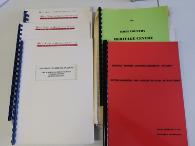
Collection of Papers and Books re - Mt Beauty Heritage Centre
In the early 1990s the KVHS applied for a grant to create the Mt Beauty Heritage Centre / Discovery Centre. This involved employing consultants and further research.This collection includes a lot of detail of the Kiewa Valley area.1. Bogong - The Alpine Discovery Centre 2. Heritage Centre - black folder 3. Heritage Centre - manila folder 4. High Country Heritage Centre - 1991 - green spiral folder 5. Six Heritage Centre - Matt Viney & Associates - white spiral folders 6. Landscape Consultants - Susan Campbell & son - red spiral folder 7. Plant List - Upper Kiewa Valley Water Supply Catchment 8. Geological Survey of Vic., Plates, Bulletin No. 44 - in battered paper 'bag' with front cover list of contents - 15 plates 9. Geological Survey - A3 photo copies of pages 106-117 10. Geological Survey of Vic. - Report of Progress No VII 1884 - bound book 11. Geological Survey of Vic. Bulletin 56 - includes nth east Vic. 1958 - bound book with green cloth spine 12. Department of Mines Report Vic. 1906 - booklet held with two staples 13. Royal Society of Vic book - The Geology of the Kiewa Area 1961 14. Miscellaneous papers - Geological Survey, Reports of Fossil Specimens and maps of local area 15. Gold - Appendix K and Appendix 111, Part C - photocopied pages from Vic Mining Registrars Report 1888 - manila foldermt beauty heritage centre, mt beauty discovery centre, geological surveys -
 Federation University Historical Collection
Booklet, Wendy Morris, A Guide to Maldon, 1983, 1983
Soft covered booklet featuring an aerial view of the town of Maldon on the cover. heritage, tourism, maldon, mining, streetscape, townscape, gardens, quartz reef mining, geology, maldon goldmines, maldon hospital, kangaroo hotel, architecture, conservation and planning, cast iron, forests, mount tarrangower, nuggetty ranges, beehive -
Churchill Island Heritage Farm
School Assignment, "Churchill Island", 1969
History project form 3 Mentone Girls Grammar School 1969 by Margaret Stott on an island within the surrounds of Australia. 11pp blue ink handwritten foolscap. 1 coloured map of Western Port showing location of Churchill Island. 17 colour photos. Stitched into brown manilla folder with blue spine.churchill island, farming, james grant, lt. murray, lady nelson, erosion, bird life, geology -
Koorie Heritage Trust
Journal - Serials, Birdsell, Joseph B. et al, Records of the Queen Victoria Museum Launceston. Contents - The racial origins of the Extinct Tasmanians. A survey of possible sea routes available to the Tasmanian Aborigines. The Tasmanians - a summary, 1949
Some of the points raised seem rather dated, but an interesting set of theories historically.105-145P.; plates; refs. figs.Some of the points raised seem rather dated, but an interesting set of theories historically.tasmanians - racial origins., australian aboriginals - origins., migration theories - tasmanians., bass strait - geology. -
Koorie Heritage Trust
Book, Baragwanath, W, Memoirs of the Geological Survey of Victoria : No. 15 The Aberfeldy District, Gippsland, 1925
15 v. : ill., plates, maps, plans, diagrs. ; 34 cm. lcsh: 1. geology -- victoria -- periodicals. 2. geology -- victoria. i. geological survey of victoria. ii. victoria. dept. of mines. -
 Ballarat Heritage Services
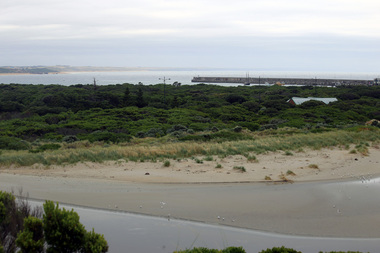
Digital photographs, Middle and Merri Islands Warrnambool, 2016
Digital images showing Middle Island and Merri Island, Warrnambool.landscape, seascape, geology, warrnambool, middle island, merri island, coast, coastal, thunderpoint -
 Ballarat Heritage Services
Digital photographs, L.J. Gervasoni, Middle Merri Island Warrnambool, 2016
Digital imageslandscape, seascape, geology, warrnambool, middle island, coast, coastal -
 Ballarat Heritage Services
Digital photographs, L.J. Gervasoni, Merri Island Warrnambool, 2016
Digital imageslandscape, seascape, geology, warrnambool, coast, coastal, merri island -
 Ballarat Heritage Services
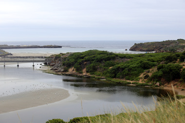
Photograph - Digital photographs, L.J. Gervasoni, Breakwater and Lady Bay, 2016
Digital imageslandscape, seascape, geology, warrnambool, coast, coastal, breakwater, lady bay -
 Ballarat Heritage Services
Digital photographs, L.J. Gervasoni, Stingray Bay and the Mouth of the Merri River, 2016
Digital image of the mouth of the Merri River at Stingray Bay. landscape, seascape, geology, warrnambool, coast, coastal, stingray bay, merri river, mouth -
 Ballarat Heritage Services
Digital photographs, L.J. Gervasoni, eroded steps, 2016
Digital imageslandscape, seascape, geology, warrnambool, coast, coastal, thunder point coastal walk, steps -
 Ballarat Heritage Services
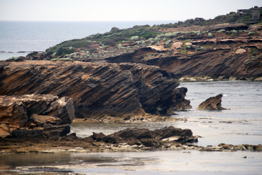
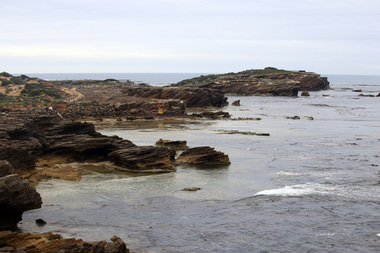
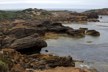
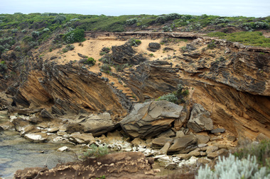
Digital photographs, L.J. Gervasoni, thunder point walk geology, 2016
Digital imageslandscape, seascape, geology, warrnambool, coast, coastal, thunder point coastal walk -
 Ballarat Heritage Services
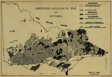
Map, Simplified Geological Map of Victoria, c1940, c1940
Physiographic map of Victoriavictoria, map, geology, geological -
 Ballarat Heritage Services
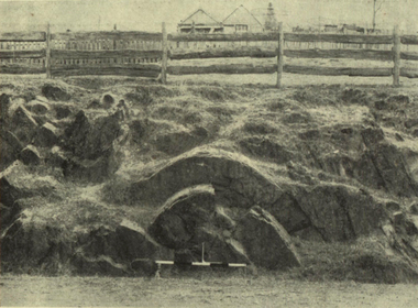
Photograph - Image, Anticlinal Fold, Lyttleton Street, Castlemaine, c1880, c1880
In 1927 a plaque was installed at this anticlinal fold. Since no plaque is evident in the photo the date would be pre1927. The plaque states "This fine exhibit was disclosed when Lyttleton Street East was constructed in 1874. Saddle reefs occur in similar folds of the sandstones and slates on lower geological horizons." An anticline at Castlemaine, Victoria. This natural feature was uncovered during Lyttleton Street roadworks in 1880. anticlinal fold, geology, castlemaine -
 Ballarat Heritage Services
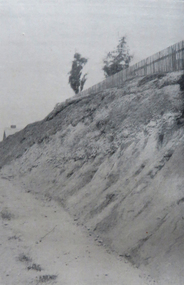
Image - Black and White, Golden Point, Ballarat
Black and white image showing the site of the earlies discovery of first rate mining importance to Australia. The gold occurs in gravel lying on Lower Palaeozoic slatesgolden point, ballarat, gold, geology, gold discovery -
 Ballarat Heritage Services
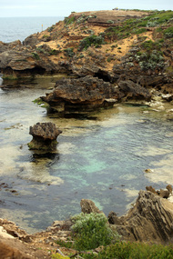
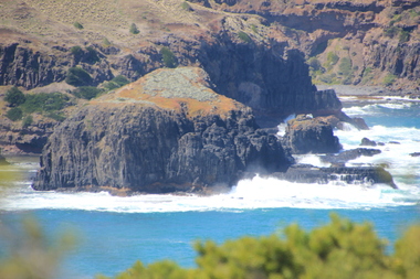
Digital photographs, L.J. Gervasoni, Bushrangers Bay, 2016
coast, coastal, coastal geomorphology, geology, ocean, waves, bushrangers bay -
 Ballarat Heritage Services
Digital photographs, L.J. Gervasoni, Cape Schank, Victoria, 2016, 2016
Colour photograph of Rocky crop at Cap Schank.coast, coastal, coastal geomorphology, geology, ocean, waves, cape schank, beach -
 Ballarat Heritage Services
Digital photographs, L.J. Gervasoni, Elephant Rock Bushrangers Bay, 2016
coast, coastal, coastal geomorphology, geology, ocean, waves, bushrangers bay, elephant rock