Showing 80 items matching "gold mining locations"
-
 Bendigo Historical Society Inc.
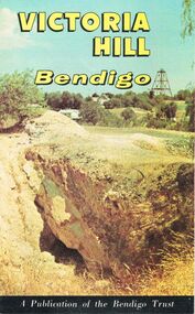
Document - JOAN O'SHEA COLLECTION: VICTORIA HILL GOLDMINING AREA BOOKLET, March 1972
Joan O'Shea Collection. Victoria Hill Bendigo Gold Mining on the Richest Quartz Reef in Bendigo, from 1854 to 1916. Colour and Black and White Booklet 16 Pages. Includes Maps of the Victoria Hill Area, photographs of the remains of a twenty head crushing battery, burnt ground from quartz roasting, The Victoria Quartz Mine Photograph from Australian Mining Standard June 1899, The compressor beds and concrete foundations for the poppet legs all that remain today of the Victoria Quartz Mine deepest mine on Bendigo Goldfield 4613 feet or 1406.04 metres. Also included photograph of the view of Victoria Hill from The New Chum Hill in the 1870s. The Location of the 3 mines Ballerstedt's open cut, North Old Chum and Lansell's 180 are marked. A depiction of Rae's Open Cut gives an understanding of the primitive nature of early workings on the Goldfields. The Booklet also provides a brief history of Victoria Hill itself.Bendigo Trust Publication March 1972. Printed in Bendigo Cambridge Press.bendigo, mining, victoria hill -
 Bendigo Historical Society Inc.
Document - MINING REPORTS - LANSELL'S BIG 180
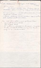
Partial page of handwritten notes on Lansell's Big 180 Mine on the New Chum Line. Notes give detailed location of the shaft, when it was formed and last production in 1916. Also some notes on the poppet legs.document, gold, mining reports, mining reports, lansell's big 180, john brown knitwear factory, caleb thomas -
 Bendigo Historical Society Inc.
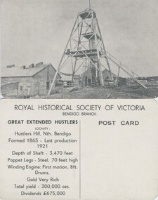
Photograph - GREAT EXTENDED HUSTLERS (POSTCARD)
Great Extended Hustlers (Postcard series of the Royal Historical Society of Victoria (Bendigo Branch). 8 identical cards. Summary history of mine on reverse, LH side: Location, depth, poppet and engine detail, gold yield, dividends. Blank (unused) on RH side for addressee.place, mining site, great extended hustler quartz mine -
 Bendigo Historical Society Inc.
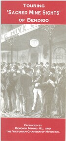
Book - TOURING 'SACRED MINE SIGHTS' OF BENDIGO, c1994
Touring 'Sacred Mine Sights' of Bendigo. Gold was discovered in 1851 and the mining era continued until 1954. Produced by Bendigo Mining NL and The Victorian Chamber of Mines Inc. Place of publication: Bendigo. 16 pages. Maps.David G Horsfallbendigo, mining, mining history guide for toursts, history bendigo mines locations -
 Bendigo Historical Society Inc.
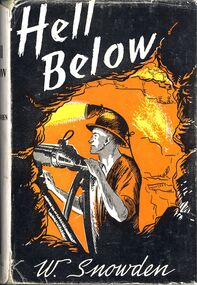
Book - HELL BELOW - LEADER, 1959
'Hell Below'. The romance of gold - fictional story of mining at Bendigo, told from the viewpoint of a man who worked below. Reference to known mines and locations in Bendigo.W Snowdenbendigo, mining, conditions at the time. -
 Bendigo Historical Society Inc.
Document - ALBERT RICHARDSON COLLECTION: SOUTH BELLEVUE COMPANY, NEW CHUM MINE, STH BELLEVUE UNITED
Three page document re South Bellevue, South Bellevue United Co and New Chum gold mines. On top of first page ' Sth Bellevue Manager T.M. Hoppers' 11.10 1886 Harkness made on baling tank 23.4.1887 50 ton firewood per week to bail water out, water making 50,000 gallons in 24 hours. All lifted with one tank. History of New Chum Mine detailed including the plant, best gold obtained. The New Chum mine location is described as follows: between Breen Street and Bendigo to Melbourne raiway line, approx 220 yards east of intersection of McDougall and Bellevue Roads.bendigo, mining, south belle vue -
 Bendigo Historical Society Inc.
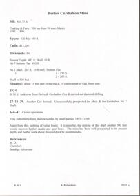
Document - GOLDEN CARSHALTON MINE - NOTES ON THE GOLDEN CARSHALTON MINE
... . Notes include location, depth, mining methods, gold production... include location, depth, mining methods, gold production. Ref: M ...Hand written notes by Albert Richardson in red on the Golden Carshalton Mine and the Forbes Carshalton Mine. Golden Carshalton Mine was formerly called the Carshalton B. M. L. Shaft. Notes include location, depth, mining methods, gold production. Ref: M. D., Chambers & Bendigo Advertiser.mine, gold, golden carshalton mine, golden carshalton mine, carshalton b. m. l. shaft, gold production, forbes carshalton, m. d., chambers, bendigo advertiser, derby & carshalton coy., carshalton no 2 shaft -
 Bendigo Historical Society Inc.
Document - FOSTERVILLE GOLD MINE COLLECTION: OPEN DAY 2018
2 page document, coloured, titled 'Kirkland Lake Gold' and 'Welcome to the Fosterville Gold Mine Open Day 2018'. Document describes activities available to visitors on the 2018 Open Day, and a map of the mine site showing location of various displays.bendigo, mining, fosterville gold mine -
 Bendigo Historical Society Inc.
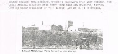
Document - CORNISH COLLECTION: THOMAS EDWARDS AND METALLURGICAL WORKS
Document. Cornish Collection - Thomas Edwards. Two pages from Bendigo and Vicinity's (badly copied with Left Hand side of page not being fully legible in page 247). Biographical details. Reference to his Pyrites Works (in Bendigo and Ballarat) - details of these works. Photo of Thomas Edwards accompanies one page and separate copy of photo shows Edward's Metallurgical Works, West Bendigo (source? / - this photo has typewritten attachment detailing location in Inglewood Road; mention of Spargo's (another Cornish owned operation of this nature).bendigo, gold mining, metallurgical works, thomas edwards. edwards metalurgical works. -
 Bendigo Historical Society Inc.
Document - MCCOLL, RANKIN AND STANISTREET COLLECTION: DEBORAH EXTENDED GOLD MINING CO. NL, 1940
McColl Rankin & Stanistreet, Deborah Extended Gold Mining Co. No Liability, Lease. Inscription: Mortgagee under Mortgage N'bd... has consented to this Lease, See consent endorsed heron (signed) F O Hewison Assistant Registrar, Registrar of Titles 14 May 1941. Leases Copy. Other signatures: Donald McKinnon, Jean Woods, Jamie Jepson, Angus Mackay, J Stanistreet, A Gilcrist, ? Healy. Common Seal for: The Bank of Australasia and Deborah Ext Gold Mining Co NL. 2 maps of mine location.organization, mining, deborah extended gold mining co nl, mccoll rankin & stanistreet, deborah extended gold mining co nl lease -
Bendigo Historical Society Inc.
Map - BIG 180 SHAFT POSITION, No date visible
Map: Plan showing the location of various shafts in the Victoria Hill area, hand draughted in pencil. Scale 2 Chains to 1 inchmap, bendigo, mining plan, mining , gold mines. victoria hill, big 180 -
 Bendigo Historical Society Inc.
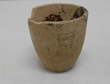
Container - CLAY CRUCIBLE
Clay gold crucible used for smelting, assaying and refining gold. Inside of crucible discoloured with brown and pale green mark. Maker's name on side: 'Juleff, number 78, (location indecipherable) England.Juleffgold mines, mining equipment, gold crucible -
Clunes Museum
Photograph, EXTENT OF MINE WORKINGS AT CLUNES, 1987
MINE WORKINGS IN CLUNESAERIAL PHOTOGRAPH CLUNES GOLD WORKINGS MAP SUPERIMPOSED. MOUNTED ON CARDBOARD WITH DETAILS OF MINE LOCATION. TYPED DESCRIPTION PASTED BELOW.port phillip mine, aerial photograph, quartz mining -
Stawell Historical Society Inc
Joiner, Joiner from Diamond Drill, C. 1955
Dimond drills are put down to identify locations of gold bearing ore deposits, before mining drives are put in to extract the Ore. Sectionso fth eDimond Drill core are analyised for gold content. Drill joiner found near shaft no 26 in Ironbarks, near the intersection of Golf Course & southwest road. Conctrete shaft Cover still in PlaceMetal pipe threaded at both ends, used to join diamond Drill pipeing c 1955mining, gold -
Stawell Historical Society Inc
Map, Gold Mines of Australia, Stawell Investment Geological Plan. Mine Area showing Mineshafts
The Reefs Mine shaft locationsGold Mines of Australia Ltd mining, gold, map -
Stawell Historical Society Inc
Map, Gold Mines of Australia, Plan of Stawell Goldfield. Mining Leases, 1952
And Shaft Locations 1952 G G Birch Mining Surveyormining, gold, map -
Whitehorse Historical Society Inc.
Legal record - Correspondence, Goldfields and mineral districts of Victoria, 1985
Letter from the State Library of Victoria about location of a gold mime near Koonung Creek in Box Hill North with a reef 2 feet in thickness which yielded 1oz per ton.Letter from the State Library of Victoria about location of a gold mime near Koonung Creek in Box Hill North with a reef 2 feet in thickness which yielded 1oz per ton. Information from R. Brough Smyth 'Goldfields and mineral districts of Victoria'. - 1869Letter from the State Library of Victoria about location of a gold mime near Koonung Creek in Box Hill North with a reef 2 feet in thickness which yielded 1oz per ton. mines and mining, state library of victoria, jackson avenue, box hill north, goldmining -
 Ballarat Tramway Museum
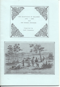
Book, Jack Cranston, "The Goldfields of Ballarat 1851 - 1886 and The Eureka Stockade", 1970's?
Book - "The Goldfields of Ballarat 1851 - 1886 and The Eureka Stockade", compiled by Jack Cranston. Comprises blue cover with 28 pages folded and stapled inside and fold out map glued to the inside of the rear cover, "Map of Ballaarat and Sebastopol" showing the various leads and gold bearing reefs of the goldfields. Also shows the location of Eureka Stockade and Sovereign Hill. Published for the Sovereign Hill Association, 1970's? Looks at the Goldfields, sources of Nuggets, mining population and statistics, the Miners Rebellion and the Stockade. Has numerous illustrations and copies of posters.trams, tramways, gold, eureka, sovereign hill -
 Bendigo Historical Society Inc.
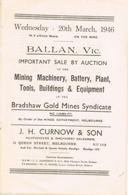
Document - IAN DYETT COLLECTION: AUCTION CATALOGUE - BRADSHAW GOLD MINES SYNDICATE
Two Auction catalogues for a sale on 20th March, 1946 of Mining Machinery, Battery, Plant, Tools, Buildings & Equipment at the Bradshaw Gold Mines Syndicate No Liability at Ballan, Vic. Sale by Order of the Mines Department, Melbourne. J. H. Curnow & Son were the auctioneers. Contains a description of some of the machinery and buildings. Also gives location of the Bradshaw Gold Mine. The Prahran Telegraph Print were the printers of the catalogue.business, auctioneers, j h curnow & son pty ltd, ian dyett collection - auction catalogue - bradshaw gold mines syndicate no liability, mines department, j h curnow & son, j l jamieson, w g wedd, mr r graham, the prahran telegraph print -
 Bendigo Historical Society Inc.
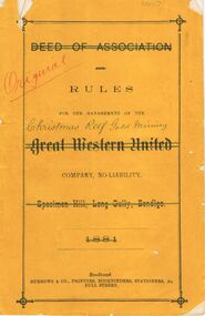
Document - CHRISTMAS REEF GOLD MINING CO. COLLECTION: RULES FOR THE MANAGEMENT
... BENDIGO Mining christmas reef gold mining Burrows & Co., Printers ...Booklet, yellow cover, Rules for the management of the Christmas Reef Gold Mining Company, No Liability. (written over Great Western United Co. Specimen Hill, Long Gully Bendigo 1881 - all crossed out) Dated 14 July 1894. Booklet has handwritten text inserted throughout. Signatures at end: J.W. ( unclear ) and W. James. Each had 12,000 shares. Booklet printed by Burrows and Co., Printers, Bull St., Sandhurst. List of principal nuggets found on Bendigo, showing nuggets by weight and location.Burrows & Co., Printers Bookbinders, Stationers & c., Bull Street.bendigo, mining, christmas reef gold mining -
 Bendigo Historical Society Inc.
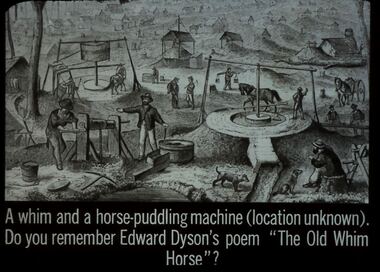
Slide - DIGGERS & MINING. GETTING THE GOLD, 1850s
Diggers & Mining. Getting the Gold. Slide: A whim and horse-puddling machine (location unknown). Do you remember Edward Dyson's poem 'The Old Whim Horse'? Shows miners at work and puddling machine being worked by horse. Markings: 46 994.LIF:4. Used as a teaching aid.hanimounteducation, tertiary, goldfields -
 Bendigo Historical Society Inc.
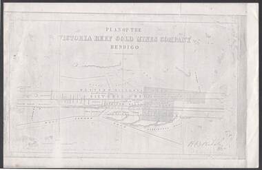
Document - VICTORIA REEF GOLD MINES COMPANY BENDIGO PLAN
Photocopy of a Plan of the Victoria Reef Gold Mines Company, Bendigo. Shaded area is the Victoria Reef Gold Mines Company Lease No. 2 and Lease No. 3. The gullies are named Happy Valley, Long, Derwent, Providence and Ironbark Gullies. The reefs are: Western Victoria, Victoria, Eastern Victoria and Prince Albert Reef. Between the Eastern Victoria Reef and the Prince Albert Reef is the White Lead. Mount Korong Road is at the bottom of the plan. Other Leaseholders are: Burrows, Wybrant, Ballerstedt, Jackson,Roberts & Co, Ashley, Grant, ?rpe, ?eau, Woodward, Coath, Taylor, Cranshaw, Roberts, Gould & Co, Midway, Witscheibe, Endeavour Co, Albert Co, Ballerstedt & Son, Late Iron Bark Quartz Mining Co, McDougall, Specimen Hill Co, Hygrect?, Wheadon, Evans and Bannerman. Signed by H. B. Nicholas. Location of Ballerstedt, Luffsman, Midway Co, Witscheibe and Rae & Co engine locations. Hills are shown as hatch shading. Written at the bottom left ocrner is: Accompanying prospectus issued in Nov. 1859. Signed H.B. Nicholas.plan, bendigo, victoria reef gold mines company, victoria reef gold mines company bendigo - plan, h b nicholas, burrows, wybrant, ballerstedt, jackson, roberts & co, ashley, grant, ?rpe, ?eau, woodward, coath, taylor, cra-shaw, roberts, gou-d & co, midway, witscheibe, endeavour co, albert co, ballerstedt & son, late iron bark quartz mining co, mcdougall, specimen hill co, hyo?, wheadon, evans, bannerman. -
 Bendigo Historical Society Inc.
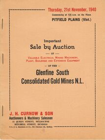
Document - IAN DYETT COLLECTION: AUCTION CATALOGUE - GLENFINE SOUTH CONSOLIDATED GOLD MINES
Beige coloured auction catalogue for an auction of electrical mining machinery, plant, buildings and extensive equipment of the Glenfine South Consolidated Gold Mines N. L. at Pitfield Plains (Vic.), held on 21st November, 1940. J. H. Curnow & Son were the auctioneer. Front cover has red and black printing. Inside the front cover there is a black and white photo of Lot 89, a Diesel Electric Generating Set. Contains descriptions of some of the lots and details of location of the sale.business, auctioneers, j h curnow & son pty ltd, ian dyett collection - auction catalogue - glenfine south consolidated gold mines n.l., j h curnow & son, the cambridge press, j l jamieson & co -
Tarnagulla History Archive
Set of Maps (Mining & Local Area), various
David Gordon Collection. A set of mining documents, maps and plans: 1. Dunolly Deep Leads - showing location and names of deep lead gold deposits in region around Dunolly including at Tarnagulla and Newbridge. Geological Survey of Victoria, Department of Minerals and Energy. Bulletin No. 62, Map No. 4 Dunolly (770 x 485 mm). 2. Poseidon Lead (Facsimile) 3. Nick O Time Lead (Facsimile) 4. Happy Go Lucky Mine prospectus and plan (colour copy) 5. Jones Creek GM Co. (Raven & Gourlay's) Waanyarra - Prospectus (colour copy) 6. Poseidon Area Plan (colour copy) and Poseidon Area map (B&W copy). 7. Cross-section diagram of Spread Eagle Reef 8. New Birthday Gold Mine - area map (colour copy) and mine cross-section ( (colour copy). 9. Cross section of Poverty Reef, by Department of Mines (B&W copy, 2 parts on A2 paper) 10. Time-Lease Graph for Watts Reef, Specimen Reef, Stony Reef, Poverty Reef (second page in detail), created by Eric WIlkinson for Ref Mining NL, 1995 11. 1859 Plan of the Gold Workings & Township of Sandy Creek, Shewing the Mining Leases, Extended Claims & Machinery by R.J. McMillan, Mining Surveyor (B&W copy) 12. Longitundinal and Transverse Vertical Sections of Poverty Reef, Sandy Creek 1859, by R.J. McMillan, Mining Surveyor (B&W copy) 13. Tarnagulla Locality Plan (B&W copy) 14. Universal Grid Reference Map (Topographic) for Laanecoorie North (2 copies) 15. Universal Grid Reference Map (Topographic) for Inglewood South 16. Poverty Reef, Plan showing shafts and early tenements, created by Eric WIlkinson for Ref Mining NL, 1995 17. Locality Map of mining leases in Tarnagulla 18. Plan and Elevation of part of Poverty Reef, Sandy Creek, showing the claims and positions of the shaft. by R.J. McMillan, Mining Surveyor (Facsimile, composed of taped together components) 19.Plan and Elevation of part of Poverty Reef, Sandy Creek, showing the claims and positions of the shaft. by R.J. McMillan, Mining Surveyor (Facsimile, composed of taped together components) -
Bendigo Historical Society Inc.
Document - CENTRAL DEBORAH GOLD MINE: ADDITIONAL MINES ALONG THE DEBORAH LINE OF REEF
BHS CollectionA4 yellow paper. List of additional mines along the Deborah reef. Walter Scott, Tadmor, Rose of England, Herschel and Tait, Vital, Metropolitan, Metropolitan South shaft, Monument Hill Central, Monument Hill old, Violet. Locations of each mine listed with name.bendigo, mining, central deborah gold mine, central deborah gold mine -
Bendigo Historical Society Inc.
Document - CENTRAL DEBORAH GOLD MINE: MINES ALONG THE DEBORAH ANTICLINE
BHS CollectionPlan of reef line showing the location of the Deborah Gold Mines. Drawn by Philip Wilkin for the 60th anniversary of the closing of the Central Deborah Gold Mine.bendigo, mining, deborah gold mines, deborah gold mines -
 Bendigo Historical Society Inc.
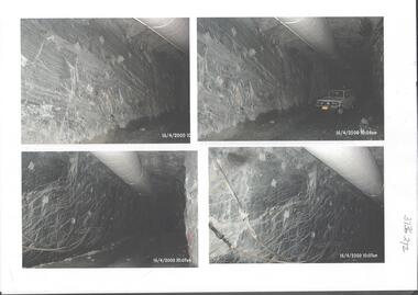
Photograph - Kangaroo Flat Gold Mine Collection: underground in Swan Decline, Kangaroo Flat Gold Mine, 2000
The modern mine is accessed via the Swan Decline, which commences at the Kangaroo Flat site on the southern outskirts of Bendigo and progresses in a north easterly direction between the Deborah and Sheepshead anticlines, reaching a depth of almost 1000 m below the City of Bendigo. Development of this decline commenced in 1998. Swan Decline closed and history preserved In a major rehabilitation milestone at Kangaroo Flat, the Swan Decline Bendigo’s primary gateway to underground mining, was permanently closed in December 2022. Important parts of Bendigo’s gold rush history were also preserved from the onsite office buildings with 19 boxes of records, and 1350 old photos being scanned and provided to the local historical societies and the Goldfields Library Corporation. A volunteer from the Bendigo Historical Society, Kay MacGregor, also scanned approximately 40 bookshelves of newspaper clippings to assist with recording and preserving geological drilling locations.Black and white photocopies of photographs of Swan Decline, showing some stages of underground construction. Eleven images on 3 pages, dated 16/4/2000 (10 a.m.) show decline walls, rock bolts and markout of tunnel shape. One image shows a utility in the tunnel. Final three images on one page, have notations on the photos: 'opposite SP18 LHS decline', 'just up from previous 3 box positions' and 'just up from tank, same side' On bottom RH side 'spots for scale attention, IT required, all lower decline.' All three images dated 12/6/2000.goldmining, kangaroo flat gold mine, western mining corporation, unity mining, swan decline -
Bendigo Historical Society Inc.
Document - POSTER GOLD NUGGETS, 1861 -1868
BHS CollectionHeavy card poster, light brown, showing location of nuggets in Eaglehawk district found in 1860s. Hand written in texta.bendigo, gold mining, nuggets -
 Buninyong & District Historical Society
Photograph - B/W photograph of shallow alluvial mine, Sepia mining scene
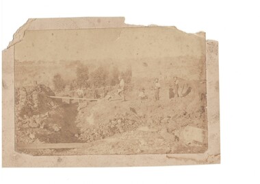
This photograph of miners at work on a shallow alluvial mine was taken around 1870 however the location, participants and precise date are unknownThis scene is typical of alluvial mining during the gold rush and up to the latter part of the 19th century showing gold miners and their equipment in actionSepia photograph of shallow mine with six miners location unknown c 1870Alluvial Mining late 19th centurygold mining, miners, tramway -
 Bendigo Historical Society Inc.
Map - Maps of Whipstick
The Whipstick was a gold mining area and is now a national park. Peter Ellis ( 1946 - 2015 ) died 27th March, 2015. Bendigo Advertiser personal notices re death and funeral; obituary and two page spread on Peter Ellis' life and contribution to the retention of Australian bush music. B. Peter Nicolaus Ellis' Service of Thanksgiving for his funeral held on 25th. May 2015 at Mulqueen Family Chapel, Bendigo.Part of the Peter Ellis Collection. Survey of Whipstick, Part 7. A detailed map of the Whipstick National Park Showing locations of wildflowers. Compiled by Peter Ellis. There is one paper copy and three Laminated paper copies which are probably preparations for the paper copy. map, whipstick, peter ellis collection, wild flowers