Showing 158 items matching "goulburn river"
-
 Koorie Heritage Trust
Book, Bossence, William Henry, Murchison : the J. G. Kenny memorial history, 1965
... Goulburn River Valley... River Valley Aboriginal Protectorate-Goulburn 40-56 Ngooraialum ...210 P.; map; facsimiles; indexes ; 21 cm.murchison-history, goulburn river valley, aboriginal protectorate-goulburn 40-56, ngooraialum tribes-customs - 23-39 -
Koorie Heritage Trust
Book, Blanks, Harvey, The Story of Yea : a 150 year history of the shire, 1973
... History -- Yea -- Muddy Creek -- Goulburn River.... -- Goulburn River. Contents: Foreword; Preface; Prologue ...Contents: Foreword; Preface; Prologue: The Dreamtime; Hume & Hovell's expedition; The coming of the overlanders; The first settlers; The Muddy Creek Aborigines; Early families & personalities; The settling of Highlands; Muddy Creek becomes Yea; Early teething troubles; The Road Board years; A bridge over troubled waters; From Mission to Church; The Shire - 1876 to 1900; Soldiers of the Queen; Into the New Century; How education came to Yea; Through Two World Wars; The Post-War Years; Appendices; Index.311 p., [16] p. of plates. : ill., maps. ; 22 cm.Contents: Foreword; Preface; Prologue: The Dreamtime; Hume & Hovell's expedition; The coming of the overlanders; The first settlers; The Muddy Creek Aborigines; Early families & personalities; The settling of Highlands; Muddy Creek becomes Yea; Early teething troubles; The Road Board years; A bridge over troubled waters; From Mission to Church; The Shire - 1876 to 1900; Soldiers of the Queen; Into the New Century; How education came to Yea; Through Two World Wars; The Post-War Years; Appendices; Index.other: yauung-illam-baluk tribe -- taungurong -- local history -- yea -- muddy creek -- goulburn river. -
 Marysville & District Historical Society
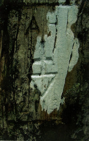
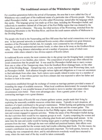
Work on paper (item) - Poem, Thelma Stucliffe, To The Sir John Franklin Gold Mine From Gooleys Creek, 01-12-2004
... goulburn river... goulburn river wood's point johnstons hill chinese miners black ...A poem that was written about a journey taken by a local miner's daughter to the Sir John Franklin gold mine from Gooleys Creek.A poem that was written about a journey taken by a local miner's daughter to the Sir John Franklin gold mine from Gooleys Creek.sir john franklin gold mine, gooleys creek, stander's track, goulburn river, wood's point, johnstons hill, chinese miners, black friday -
Marysville & District Historical Society
Flyer (item) - Brochure, Artworkz Tourism, Marysville-Steavenson Falls, 2018
... of the beautiful Goulburn River/ and Lake Eildon. This is our playground.... of the beautiful Goulburn River/ and Lake Eildon. This is our playground ...A brochure including photographs and a tourist map of Marysville and some of the area's attractions focusing on Steavenson Falls. A brochure including photographs and a tourist map of Marysville and some of the area's attractions focusing on Steavenson Falls. The Steavenson Falls is named after the Victorian Assistant Commissioner of Roads and Bridges, John Steavenson who arrived in Victoria in the early 1860s.Shadowed by over 30 Mountains and/ on the banks of the beautiful Goulburn River/ and Lake Eildon. This is our playground.marysville, steavenson falls, victoria, waterfalls, john steavenson -
 Victoria Police Museum
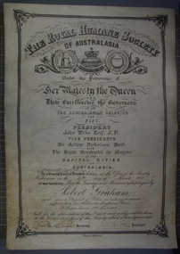
Certificate and Scroll (Robert Graham), 1888
... for rescuing sufferers from the flood at the Goulburn River... at the Goulburn River at Shepparton on 7th November 1887 Certificate ...Black embossed leather scroll with printed and handwritten Royal Humane Society Award Certificate awarded to Robert Graham for rescuing sufferers from the flood at the Goulburn River at Shepparton on 7th November 1887robert graham, greta, kelly gang, ellen kelly, royal humane society, bravery, awards, shepparton -
Tatura Irrigation & Wartime Camps Museum
Newspapers re/ local floods 1974, McPherson's Printing Group, Victoria, Tatura Guardian & Shepparton News, May 1974
... May 1974. Relating to record floods in the Goulburn River... to record floods in the Goulburn River affecting Shepparton ...Detailed history of 1974 floods in Shepparton and Mooroopna.Tatura Guardian 22 May 1974. Shepparton News 17th & 18th May 1974. Relating to record floods in the Goulburn River affecting Shepparton, Mooroopna, and Undera and to a lesser degree Tatura and Merrigum.record floods mooroopna & shepparton -
Tatura Irrigation & Wartime Camps Museum
Book, Methodist Church in Goulburn Valley - 1873 - 1977, 1977
... at Goulburn River 1896 - top of front cover and picture of centenary... cover. Picture of Methodist picnic at Goulburn River 1896 - top ...To record the history of Methodist Churches in Goulburn Valley. As now it will be called the Uniting Church from 1977. Includes history of Tatura Methodist ChurchBlack and white cover. Picture of Methodist picnic at Goulburn River 1896 - top of front cover and picture of centenary service 30th September, 1973. Site of Furphy's blacksmith shop - 1st service held in 1873.methodist churches in goulburn valley, tatura methodist church, uniting churches in victoria, history of methodist church -
Tatura Irrigation & Wartime Camps Museum
Folder, Articles on History of Waranga Basin, 2000
... . Maps. Other stories of families at Basin, Goulburn River... River and Goulburn Weir history of waranga basin knee l tatura ...Extract from Waranga News on early history of Waranga Basin. Maps. Other stories of families at Basin, Goulburn River and Goulburn WeirBlue cover. Black spiral spine. White label. Title in blue penhistory of waranga basin, knee l, tatura, irrigation, books, history, local, rural -
Tatura Irrigation & Wartime Camps Museum
Program, Goulburn Weir Rehabilitation Works Opening Ceremony
... of Victoria, map, Goulburn River system... names of Victoria, map, Goulburn River system irrigation ...Includes weir construction history, aboriginal names of Victoria, map, Goulburn River systemProgram of Opening Ceremony. White paper, black writing, blue water wheel logo in plastic sleeveirrigation, document, program, rural, industry -
 Parks Victoria - Days Mill and Farm
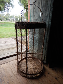
Container - Traps
... , nearby in the Goulburn River or other waterways. ... freshwater crayfish or yabbies, nearby in the Goulburn River or other ...Possibly used for catching freshwater crayfish or yabbies, nearby in the Goulburn River or other waterways. of critical significanceHOMEMADE WIRE TRAPS x 2. Made from chicken wire. Iron bands supported by green timber lengths. Wire handles with metal spike probably for securing trap to bank/ ground.fishing, food -
Tatura Irrigation & Wartime Camps Museum
Book, Those Were the Days, 1962
... aborigines to discovery and naming of Goulburn River. Early... from early aborigines to discovery and naming of Goulburn River ...To record a history of Shepparton & District from early aborigines to discovery and naming of Goulburn River. Early explorers and settlers. R West was Town Clerk 1927-1960Pale blue hard cover, old letters. Pink and brown dust jacket. Title in black on yellow square. Author's name in black on yellow strip. 283 pages.those were the days, west r, ford t, aborigines, shepparton and district history, early explorers of shepparton, town clerk of shepparton -
 Tatura Irrigation & Wartime Camps Museum
Photograph, Paddle Steamer "Arbuthnot", 1986
... on Goulburn River, upstream of Shepparton. Photo taken 1986 during.... Located on Goulburn River, upstream of Shepparton. Photo taken ...Paddle Steamer "Arbuthnot", purchased by the Shire of Rodney to be restored using unemployment relief funding. Located on Goulburn River, upstream of Shepparton. Photo taken 1986 during river flooding. Now restored at Echuca.|Rodney Shire -
Tatura Irrigation & Wartime Camps Museum
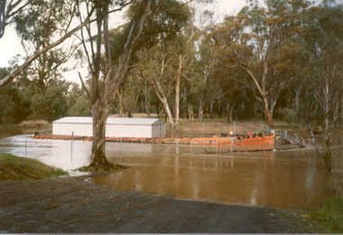
Photograph - copy, William Day's Flour Mill, 1987 copy
... . Overlooking the Goulburn River, where a punt carried people, livestock... Valley. Overlooking the Goulburn River, where a punt carried ...Copy of photograph of flour mill l built by William Day in 1858. The earliest flour mill in the Goulburn Valley. Overlooking the Goulburn River, where a punt carried people, livestock and mill products to and from the mill. Classified by National Trust. Photographs courtesy of R. Day.Black and white copy of photograph of exterior of William Day's Flour Mill, near Murchison. Built 1858.on back: Description taped to back -
 Whitehorse Historical Society Inc.
Article, The Traditional owners of the Whitehorse region, 1997
... of the Goulburn River area are described. Daily life as hunter gatherers... with the people of the Goulburn River area are described. Daily life ...Article written for Box Hill Historical SocietyArticle written for Box Hill Historical Society describing the Aboriginal (Koorie) inhabitants of the Whitehorse region. This area was part of the estate of the Wurundjeri-bulluk clan of the Woiwurung Tribe. Kinship and marriage links with the people of the Goulburn River area are described. Daily life as hunter gatherers is described and the pattern of movements within the area. Several locations where traces are still found and where people lived after European settlement are listed. A bibliography is included. 2 pages.Article written for Box Hill Historical Societyaborigines, wurundjeri -
 Beechworth Honey Archive
Hand-Written Copy of Particulars and Conditions of Sale of Land May 1922
... for a piece of land in Moira county (East of Goulburn River, South... in Moira county (East of Goulburn River, South of Murray River ...This item consists of two pages. Page One: Hand-written copy of a Particulars and Conditions of Sale of Land for a piece of land in Moira county (East of Goulburn River, South of Murray River, West of Ovens River). Also inculded is a hand-written copy of a Particulars and Conditions of a Contract of Sale; Frank L. Frost is selling land to Bridget Ellen Ryan. Takes place in May 1922. Copy of Transfer of Land Title. Purchase price £478.11.3 Page Two: A list of Parish, Shire and County locations. Both pages written with black ink on paper. hand written, hand-written, particulars, conditions, sale, land, title, parish, shire, county, ryan, frost, beekeeper, beechworth honey -
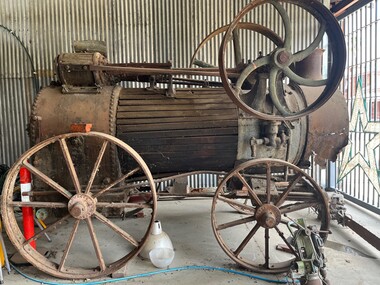 Port of Echuca
Functional object - Boiler engine, 1927
... and ran a pump on their property by the Goulburn River. The boiler... and ran a pump on their property by the Goulburn River. The boiler ...This is the Ruston and Proctor engine and boiler from the PS Little Wonder built by R Barbour, Cornella NSW. It was launched in December 1878. Owned by Murray River Sawmills, it was used for logging operations until 1904, when the vessel was dismantled. The engine and boiler was purchased by the Robins family and ran a pump on their property by the Goulburn River. The boiler was later condemned by the engine continued to be used with steam supplied by another boiler up until the 1950s. Now considered to be beyond repair. A good example of the technology and industrial history of northern Victoria and along the Goulburn River. boiler, steam display, steam garage, ruston and proctor -
Tatura Irrigation & Wartime Camps Museum
Book, The Supply of Water for Irrigation in Victoria 1881-1981, 1981
... Includes history of early irrigation schemes, Goulburn..., Goulburn system, river Murray system, Post war expansion, drainage ...Includes history of early irrigation schemes, Goulburn system, river Murray system, Post war expansion, drainage and salinity. Change from State Rivers & Water Supply Commission to Rural CommissionCream cover, black writing. Cover photo of early days of irrigation, many channels constructed by teams of horses dragging scoops.sr & wscommision, books, rural, industry -
Tatura Irrigation & Wartime Camps Museum
Photograph, Goulburn Weir Sign, 1970s
... Goulburn Weir - "State rivers and Water Supply Commission/Goulburn... and Water Supply Commission. goulburn weir victorian state rivers ...Taken by photographer for State Rivers and Water Supply Commission.Medium sized black and white photograph. Sign describing Goulburn Weir - "State rivers and Water Supply Commission/Goulburn Weir/Diversion Headworks for Goulburn Irrigation System/Designed and Constructed by Victorian Water Supply Department 1891./Full Supply Level is 408 Feet Above Sea Level/Stuart Murray M.I.C.E Chief Engineer/William Henderson A.M.I.C.E Supervising Engineer."goulburn weir, victorian state rivers and supply commission -
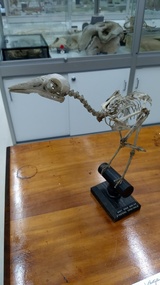 University of Melbourne, Tiegs Museum of Zoology
Grey Currawong (Strepera versicolor) mounted skeleton, Mid to late 19th century
... (aged[?]), Goulburn River' (Eastern Grey Kangaroo), ♀ skull... (aged[?]), Goulburn River' (Eastern Grey Kangaroo), ♀ skull ...The museum register is somewhat ambiguous but it is recorded - along with about 12 others - that this specimen was transferred from the 'Nat. Sc. Dept' in September 1899. The specimen also apparently has something to do with Frederick McCoy; his name is entered as the party that identified the skeleton. It seems certain that these were a batch (accession numbers MUZD1113-1126) of specimens given to the university teaching museum during the move of the state museum from the university campus to its subsequent site on Russell St. Examination of the Currawong skeleton (and some of the others in this batch) revels that the specimen has been remounted at some point. The other items in this batch are, like this specimen, predominantly mounted articulated vertebrate skeletons: [Specimens are listed with accession number and name as written in the original register] MUZD1113 - 'Lepus timidus' (Mountain hare), mounted skeleton; currently on display in the Tiegs Zoology Museum MUZD1114 - 'Emydura' (Short-necked Turtle), mounted skeleton; currently on display in the Tiegs Zoology Museum MUZD1115 - 'Astur novaehollandiae' (Obsolete binomial name for Accipiter novaehollandiae - Grey Goshawk); mounted skeleton, currently in storage, disassembled, in the Tiegs Zoology Museum. MUZD1116 - 'Grey crow-shrike ♂' (Grey Currawong), mounted skeleton; currently on display in the Tiegs Zoology Museum MUZD1117 - 'Herpestes, India' (Mongoose sp.), mounted skeleton; currently on display in the Tiegs Zoology Museum MUZD1118 - 'Macropus giganteus (aged[?]), Goulburn River' (Eastern Grey Kangaroo), ♀ skull; whereabouts unknown MUZD1119 - 'Macropus giganteus, ?' (Eastern Grey Kangaroo), skull; whereabouts unknown MUZD1120 - 'Raia ? lemprieri' (Obsolete binomial name for Dentiraja lemprieri -Thornback Skate), stuffed; whereabouts unknown MUZD1121 - 'Cyprinus carpio' (Common carp), skeleton - roughly prepared; whereabouts unknown MUZD1122 - 'Ovis' (Domestic sheep probably Jacob Sheep, '4 horned breed'), skull; whereabouts unknown MUZD1123 - 'Cervus canadensis (Wapiti)', skull and lower jaw - no horns; currently on display in the Tiegs Zoology Museum MUZD1124 - 'Antelope', no further information; whereabouts unknown MUZD1125 - 'Encope emarginata' (Echinoderm), currently on display in the Tiegs Zoology Museum MUZD1126 - 'Heterocentrotus trigonarius' (Pencil urchin), currently on display in the Tiegs Zoology Museum (accession number is not written on wooden base, but on the inside of the specimen.)Mounted skeleton of Grey Currawong (Strepera versicolor). Skeleton is mounted on a black wooden stand with a round base.Accession number '2259' is written in ink on the sternum. Wooden mount has black label with white text on the base reading 'GREY CROW SHRIKE/ STREPERA VERSICOLOR'. animal, vertebrate, bird, skeleton, frederick mccoy, national museum of victoria, passeriformes, artamidae -
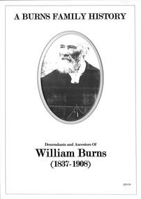 Ringwood and District Historical Society
Book, A Burns Family History, 2019
... at Burns Bridge 1.1.2 Renaming of Burns Bridge over Goulburn River... at Burns Bridge 1.1.2 Renaming of Burns Bridge over Goulburn River ...Descendants and Ancestors of William Burns (1837-1908) Compiled by Neville Burns (Great Grandson) and Meaghan Bosaid (GG Granddaughter).CONTENTS INTRODUCTION Chapter 1 - William Burns and descendants. 1.1 William Burns (Great Grandfather) 1.1.1 Bridge Inn at Burns Bridge 1.1.2 Renaming of Burns Bridge over Goulburn River 1.2 George Paul Burns (Grandfather) 1.2.1 Spouse 1.2.2 Sons 1.3 Clarence (Clarrie) Henry Burns (Father) 1.3.1 Spouse 1.3.2 Children 1.4 Neville Clarence Burns 1.4.1 Spouse 1.4.2 Children 1.4.3 Some Recollections of Early Ringwood Chapter 2 - Ancestors of William Burns 2.1 Summary of Ancestors of William Burns 2.2 Detail of each generation of Ancestors ACKNOWLEDGEMENTS In compiling this Burns History some of the information came from our own family records and recollections, but the greater input, particularly the early historical content, was obtained from the resources and records of organisations and Societies and other published material mentioned herein. I would like to acknowledge and thank Russ Haines and Members of the Ringwood and District Historical Society who unearthed the many photographic records of early Ringwood and the various articles related to the Burns family. I also thank the society for authorising the use of a number of relevant photographs, some of which appear in Hugh Andersons Book - Ringwood - Place of Many Eagles. Early information of the Burns family was also obtained from the Mansfield Historical Society and the Jamieson Historical Society and I thank the volunteer staff of both organisations for their help. Electronic files of the book added 15 October 2024 -
 Eltham District Historical Society Inc
Photograph, Hume and Hovell passed here at Seymour 28 Oct 1824, Spring Excursion, Hume and Hovell's 1824 expedition (Part 2), 26 October 1997, 26/10/1997
... the Goulburn River near Molesworth where banks were high, water deep... the Goulburn River near Molesworth where banks were high, water deep ...[article by Diana Bassett-Smith in EDHS Newsletter No. 117, November 1997:] MONUMENT HUNTING THE HUME AND HOVELL WAY - Sunday October 26 1997 dawned bright and very warm. Some twenty-five members, complete with picnic baskets, met outside the Eltham Library awaiting the Cobb and Co. large coach which would be taking us on the second leg of our travels along the route of the early explorers Hume and Hovell. Stephen West was our very good driver for the day. He would be guided around the circuitous route by Russell Yeoman who had made a detailed study, not only of the intended route, but of the story of these two explorers. During the trip Russell regaled us with poetry, quotations from the Journals and the History of the Shire of Seymour, "The New Crossing Place" by Martindale, 1982, (now Mitchell Shire due to the recent amalgamations). We headed towards the Hume Highway via Greensborough and Cooper Street and proceeded north to our first stop, noting on the way Monument Hill in the distance which is near Kilmore and, according to Russell, well worth the effort to visit as the view across the valley is magnificent. Past Sunday Creek Valley, Mt Piper and Mt Disappointment, all traversed and noted and named by them. We passed through Tallarook, then onto Seymour where we took photos of the monument telling us that Hume and Hovell had passed through on the 28th of October 1824. We also deviated down Hume and Hovell Road viewing deer and emu farming and the Bellbourie property now a sanctuary. Leaving Seymour behind we travelled up the Avenel Road to the Avenel monument, pyramidal in design of four reducing square blocks with a sharply pointed peak, erected in 1924 in memory of the 1824 exploration. The day was warming up and the countryside showing the dryness of the current drought. A parallel note had been made in their journal too of 1824 of the drought appearance of the country they were traversing. At Seven Creeks, Euroa we stopped for some minutes to check the monument placed 20th November 1924 to commemorate their passage on the 29th December 1824. More photos. Russell had pointed out the abrupt termination of the distant ranges which is noted in their journal. The next monument is beside the road at the entrance to Honey Suckle Creek Caravan Park, Violet Town. The squarish shaped monument some eight feet high is topped with a simple steel cross, and was to mark the date of 28th December 1824 and built for the 20th November 1924. By now it was 12.20 and nearly lunchtime as we drove along the Warranbayne Road to Roach's Road, monument hunting without success. Though there is a large, what appears to be an old timber sign which was hard to read, maybe this was the lost monument. In many of the paddocks hay had been cut and baled or was being cut, what a contrast to the rugged country they had passed through which was smoky from the fires of the natives burning off. By 1.00 pm we were at Benalla and pulled up beside the park where abundant beds of roses filled the air with their scent and the smell of barbecued food twitched the nostrils whilst the cheerful sounds of other picnickers could be heard throughout the park. We left the bus and collected up our picnics, dispersed to the various tables and enjoyed the shade from the various European trees. 2.00 pm and we were on the road again driving along the Benalla, Mansfield, Yea road. The Swanpool monument states that they passed four miles south and returned three miles north. Then we stopped at the Barjarg monument which notes that they camped near this spot. It is again a pyramidal monument and this time topped with a steel arrow indicating their route of the 29th November 1824. Half an hour later we came to another monument, again with a steel arrow marker on top and the plaque dated the 2nd of 12th 1824. Erected on the 12th of 12th 1924. "They blazed the way that we might inherit the land." Another square based and needle topped monument appeared at Yarck near Yea and this plaque records the date of 3 December 1824. Near McGuigans Road Russell related that the expedition had lost a dog but it had found them next day, the dog was apparently torn by a kangaroo. A short while later Russell reminded us here of the problems they encountered in crossing the Goulburn River near Molesworth where banks were high, water deep and wide. "Good coat of grass but quite dry due to drought". At Yea we stopped for afternoon tea and raided the last of our picnics and looked at the monument to their journey of 1824, situated at a corner of the gardens near the bowling green. No photo – we were out of film. We returned home via Kinglake West and Whittlesea past the Yan Yean Reservoir, not full. 5.00 pm back at Eltham we emptied out of the bus and everyone, including Joan Cole, collected their things, Joan also had the major souvenir of the day, a large carp she had picked up from the river bank, her cat was in for a great feast. The day was made so interesting by the informed commentary which Russell provided. His background knowledge of the route and nature of the journey could only have come from many hours of reading and driving the area. Thank you to Russell and to everyone who made the day so informative and pleasurable. Colour photographactivities, hume and hovell, monument, seymour -
 Eltham District Historical Society Inc
Photograph, Spring Excursion, Hume and Hovell's 1824 expedition (Part 2), 26 October 1997, 26/10/1997
... the Goulburn River near Molesworth where banks were high, water deep... the Goulburn River near Molesworth where banks were high, water deep ...[article by Diana Bassett-Smith in EDHS Newsletter No. 117, November 1997:] MONUMENT HUNTING THE HUME AND HOVELL WAY - Sunday October 26 1997 dawned bright and very warm. Some twenty-five members, complete with picnic baskets, met outside the Eltham Library awaiting the Cobb and Co. large coach which would be taking us on the second leg of our travels along the route of the early explorers Hume and Hovell. Stephen West was our very good driver for the day. He would be guided around the circuitous route by Russell Yeoman who had made a detailed study, not only of the intended route, but of the story of these two explorers. During the trip Russell regaled us with poetry, quotations from the Journals and the History of the Shire of Seymour, "The New Crossing Place" by Martindale, 1982, (now Mitchell Shire due to the recent amalgamations). We headed towards the Hume Highway via Greensborough and Cooper Street and proceeded north to our first stop, noting on the way Monument Hill in the distance which is near Kilmore and, according to Russell, well worth the effort to visit as the view across the valley is magnificent. Past Sunday Creek Valley, Mt Piper and Mt Disappointment, all traversed and noted and named by them. We passed through Tallarook, then onto Seymour where we took photos of the monument telling us that Hume and Hovell had passed through on the 28th of October 1824. We also deviated down Hume and Hovell Road viewing deer and emu farming and the Bellbourie property now a sanctuary. Leaving Seymour behind we travelled up the Avenel Road to the Avenel monument, pyramidal in design of four reducing square blocks with a sharply pointed peak, erected in 1924 in memory of the 1824 exploration. The day was warming up and the countryside showing the dryness of the current drought. A parallel note had been made in their journal too of 1824 of the drought appearance of the country they were traversing. At Seven Creeks, Euroa we stopped for some minutes to check the monument placed 20th November 1924 to commemorate their passage on the 29th December 1824. More photos. Russell had pointed out the abrupt termination of the distant ranges which is noted in their journal. The next monument is beside the road at the entrance to Honey Suckle Creek Caravan Park, Violet Town. The squarish shaped monument some eight feet high is topped with a simple steel cross, and was to mark the date of 28th December 1824 and built for the 20th November 1924. By now it was 12.20 and nearly lunchtime as we drove along the Warranbayne Road to Roach's Road, monument hunting without success. Though there is a large, what appears to be an old timber sign which was hard to read, maybe this was the lost monument. In many of the paddocks hay had been cut and baled or was being cut, what a contrast to the rugged country they had passed through which was smoky from the fires of the natives burning off. By 1.00 pm we were at Benalla and pulled up beside the park where abundant beds of roses filled the air with their scent and the smell of barbecued food twitched the nostrils whilst the cheerful sounds of other picnickers could be heard throughout the park. We left the bus and collected up our picnics, dispersed to the various tables and enjoyed the shade from the various European trees. 2.00 pm and we were on the road again driving along the Benalla, Mansfield, Yea road. The Swanpool monument states that they passed four miles south and returned three miles north. Then we stopped at the Barjarg monument which notes that they camped near this spot. It is again a pyramidal monument and this time topped with a steel arrow indicating their route of the 29th November 1824. Half an hour later we came to another monument, again with a steel arrow marker on top and the plaque dated the 2nd of 12th 1824. Erected on the 12th of 12th 1924. "They blazed the way that we might inherit the land." Another square based and needle topped monument appeared at Yarck near Yea and this plaque records the date of 3 December 1824. Near McGuigans Road Russell related that the expedition had lost a dog but it had found them next day, the dog was apparently torn by a kangaroo. A short while later Russell reminded us here of the problems they encountered in crossing the Goulburn River near Molesworth where banks were high, water deep and wide. "Good coat of grass but quite dry due to drought". At Yea we stopped for afternoon tea and raided the last of our picnics and looked at the monument to their journey of 1824, situated at a corner of the gardens near the bowling green. No photo – we were out of film. We returned home via Kinglake West and Whittlesea past the Yan Yean Reservoir, not full. 5.00 pm back at Eltham we emptied out of the bus and everyone, including Joan Cole, collected their things, Joan also had the major souvenir of the day, a large carp she had picked up from the river bank, her cat was in for a great feast. The day was made so interesting by the informed commentary which Russell provided. His background knowledge of the route and nature of the journey could only have come from many hours of reading and driving the area. Thank you to Russell and to everyone who made the day so informative and pleasurable. Colour photographactivities, hume and hovell, bridge -
 Eltham District Historical Society Inc
Photograph, Spring Excursion, Hume and Hovell bus tour Stage 2, Seymour, Benalla; 26 Oct 1997, 26/10/1997
... the Goulburn River near Molesworth where banks were high, water deep... the Goulburn River near Molesworth where banks were high, water deep ...MONUMENT HUNTING THE HUME AND HOVELL WAY (Newsletter No. 117, November 1997, by Diana Bassett-Smith) Sunday October 26 1997 dawned bright and very warm. Some twenty-five members, complete with picnic baskets, met outside the Eltham Library awaiting the Cobb and Co. large coach which would be taking us on the second leg of our travels along the route of the early explorers Hume and Hovell. Stephen West was our very good driver for the day. He would be guided around the circuitous route by Russell Yeoman wh9 had made a detailed study, not only of the intended route, but of the story of these two explorers. During the trip Russell regaled us with poetry, quotations from the Journals and the History of the Shire of Seymour, "The New Crossing Place: by Martindale, 1982, (now Mitchell Shire due to the recent amalgamations). We headed towards the Hume Highway via Greensborough and Cooper Street and proceeded north to our first stop, noting on the way Monument Hill in the distance which is near Kilmore and, according to Russell, well worth the effort to visit as the view across the valley is magnificent. Past Sunday Creek Valley, Mt Piper and Mt Disappointment, all traversed and noted and named by them. We passed through Tallarook, then onto Seymour where we took photos of the monument telling us that Hume and Hovell had passed through on the 28th of October 1824. We also deviated down Hume and Hovell Road viewing deer and emu farming and the Bellbourie property now a sanctuary. Leaving Seymour behind we travelled up the Avenel Road to the Avenel monument, pyramidal in design of four reducing square blocks with a sharply pointed peak, erected in 1924 in memory of the 1824 exploration. The day was warming up and the countryside showing the dryness of the current drought. A parallel note had been made in their journal too of 1824 of the drought appearance of the country they were traversing. At Seven Creeks, Euroa we stopped for some minutes to check the monument placed 20th November 1924 to commemorate their passage on the 29th December 1824. More photos. Russell had pointed out the abrupt termination of the distant ranges which is noted in their journal. The next monument is beside the road at the entrance to Honey Suckle Creek Caravan Park, Violet Town. The squarish shaped monument some eight feet high is topped with a simple steel cross, and was to mark the date of 28th December 1824 and built for the 20th November 1924. By now it was 12.20 and nearly lunchtime as we drove along the Warranbayne Road to Roach's Road, monument hunting without success. Though there is a large, what appears to be an old timber sign which was hard to read, maybe this was the lost monument. In many of the paddocks hay had been cut and baled or was being cut, what a contrast to the rugged country they had passed through which was smoky from the fires of the natives burning off By 1.00 pm we were at Benalla and pulled up beside the park where abundant beds of roses filled the air with their scent and the smell of barbecued food twitched the nostrils whilst the cheerful sounds of other picnickers could be heard throughout the park. We left the bus and collected up our picnics, dispersed to the various tables and enjoyed the shade from the various European trees. 2.00 pm and we were on the road again driving along the Benalla, Mansfield, Yea road. The Swanpool monument states that they passed four miles south and returned three miles north. Then we stopped at the Barjarg monument which notes that they camped near this spot. It is again a pyramidal monument and this time topped with a steel arrow indicating their route of the 29th November 1824. Half an hour later we came to another monument, again with a steel arrow marker on top and the plaque dated the 2nd of 12th 1824. Erected on the 12th of 12th 1924. "They blazed the way that we might inherit the land." Another square based and needle topped monument appeared at Yarck near Yea and this plaque records the date of 3 December 1824. Near McGuigans Road Russell related that the expedition had lost a dog but it had found them next day, the dog was apparently torn by a kangaroo. A short while later Russell reminded us here of the problems they encountered in crossing the Goulburn River near Molesworth where banks were high, water deep and wide. "Good coat of grass but quite dry due to drought". At Yea we stopped for afternoon tea and raided the last of our picnics and looked at the monument to their journey of 1824, situated at a corner of the gardens near the bowling green. No photo – we were out of film. We returned home via Kinglake West and Whittlesea past the Yan Yean Reservoir, not full. 5.00 pm back at Eltham we emptied out of the bus and everyone, including Joan Cole, collected their things, Joan also had the major souvenir of the day, a large carp she had picked up from the river bank, her cat was in for a great feast. The day was made so interesting by the informed commentary which Russell provided. His background knowledge of the route and nature of the journey could only have come from many hours of reading and driving the area. Thank you to Russell and to everyone who made the day so informative and pleasurable. Diana Bassett-Smith. Record of the Society's history of activities - Spring 1997 excursionRoll of 35mm colour negative film, 6 stripsFuji 200shire of eltham historical society, activities, pretty hill, seymour, benalla, hume and hovell, monuments -
 Eltham District Historical Society Inc
Photograph, Spring Excursion, Hume and Hovell bus tour Stage 2, Seymour, Benalla; 26 Oct 1997, 26/10/1997
... the Goulburn River near Molesworth where banks were high, water deep... the Goulburn River near Molesworth where banks were high, water deep ...MONUMENT HUNTING THE HUME AND HOVELL WAY (Newsletter No. 117, November 1997, by Diana Bassett-Smith) Sunday October 26 1997 dawned bright and very warm. Some twenty-five members, complete with picnic baskets, met outside the Eltham Library awaiting the Cobb and Co. large coach which would be taking us on the second leg of our travels along the route of the early explorers Hume and Hovell. Stephen West was our very good driver for the day. He would be guided around the circuitous route by Russell Yeoman wh9 had made a detailed study, not only of the intended route, but of the story of these two explorers. During the trip Russell regaled us with poetry, quotations from the Journals and the History of the Shire of Seymour, "The New Crossing Place: by Martindale, 1982, (now Mitchell Shire due to the recent amalgamations). We headed towards the Hume Highway via Greensborough and Cooper Street and proceeded north to our first stop, noting on the way Monument Hill in the distance which is near Kilmore and, according to Russell, well worth the effort to visit as the view across the valley is magnificent. Past Sunday Creek Valley, Mt Piper and Mt Disappointment, all traversed and noted and named by them. We passed through Tallarook, then onto Seymour where we took photos of the monument telling us that Hume and Hovell had passed through on the 28th of October 1824. We also deviated down Hume and Hovell Road viewing deer and emu farming and the Bellbourie property now a sanctuary. Leaving Seymour behind we travelled up the Avenel Road to the Avenel monument, pyramidal in design of four reducing square blocks with a sharply pointed peak, erected in 1924 in memory of the 1824 exploration. The day was warming up and the countryside showing the dryness of the current drought. A parallel note had been made in their journal too of 1824 of the drought appearance of the country they were traversing. At Seven Creeks, Euroa we stopped for some minutes to check the monument placed 20th November 1924 to commemorate their passage on the 29th December 1824. More photos. Russell had pointed out the abrupt termination of the distant ranges which is noted in their journal. The next monument is beside the road at the entrance to Honey Suckle Creek Caravan Park, Violet Town. The squarish shaped monument some eight feet high is topped with a simple steel cross, and was to mark the date of 28th December 1824 and built for the 20th November 1924. By now it was 12.20 and nearly lunchtime as we drove along the Warranbayne Road to Roach's Road, monument hunting without success. Though there is a large, what appears to be an old timber sign which was hard to read, maybe this was the lost monument. In many of the paddocks hay had been cut and baled or was being cut, what a contrast to the rugged country they had passed through which was smoky from the fires of the natives burning off By 1.00 pm we were at Benalla and pulled up beside the park where abundant beds of roses filled the air with their scent and the smell of barbecued food twitched the nostrils whilst the cheerful sounds of other picnickers could be heard throughout the park. We left the bus and collected up our picnics, dispersed to the various tables and enjoyed the shade from the various European trees. 2.00 pm and we were on the road again driving along the Benalla, Mansfield, Yea road. The Swanpool monument states that they passed four miles south and returned three miles north. Then we stopped at the Barjarg monument which notes that they camped near this spot. It is again a pyramidal monument and this time topped with a steel arrow indicating their route of the 29th November 1824. Half an hour later we came to another monument, again with a steel arrow marker on top and the plaque dated the 2nd of 12th 1824. Erected on the 12th of 12th 1924. "They blazed the way that we might inherit the land." Another square based and needle topped monument appeared at Yarck near Yea and this plaque records the date of 3 December 1824. Near McGuigans Road Russell related that the expedition had lost a dog but it had found them next day, the dog was apparently torn by a kangaroo. A short while later Russell reminded us here of the problems they encountered in crossing the Goulburn River near Molesworth where banks were high, water deep and wide. "Good coat of grass but quite dry due to drought". At Yea we stopped for afternoon tea and raided the last of our picnics and looked at the monument to their journey of 1824, situated at a corner of the gardens near the bowling green. No photo – we were out of film. We returned home via Kinglake West and Whittlesea past the Yan Yean Reservoir, not full. 5.00 pm back at Eltham we emptied out of the bus and everyone, including Joan Cole, collected their things, Joan also had the major souvenir of the day, a large carp she had picked up from the river bank, her cat was in for a great feast. The day was made so interesting by the informed commentary which Russell provided. His background knowledge of the route and nature of the journey could only have come from many hours of reading and driving the area. Thank you to Russell and to everyone who made the day so informative and pleasurable. Diana Bassett-Smith. Record of the Society's history of activities - Spring 1997 excursionRoll of 35mm colour negative film, 6 stripsFuji 200shire of eltham historical society, activities, pretty hill, seymour, benalla, hume and hovell, monuments