Showing 52 items
matching grant street garden
-
 Federation University Historical Collection
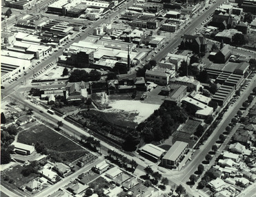
Photograph - Black and White, Aerial View of the Ballarat School of Mines
Aerial photograph of the Ballarat School of Mines soon after the Ballarat Gaol was demolished. The photograph shows the Corbould Building, tennis court, Model Mine, Ballarat Junior Technical School, Administration Building, former Wesleyan Church, Former Court House, Former Ballarat Gaol walls, Old Plumbing Building, Old Chemistry Building, Botanical Gardens, Corbould Hall, Ballarat Brewery, Ballarat Girls' School, Albert Street, Grant Street, Hickman Streetcorbould building, ballarat school of mines tennis court, model mine, ballarat junior technical school, administration building, former wesleyan church, former court house, former ballarat gaol walls, old plumbing building, old chemistry building, botanical gardens, corbould hall, ballarat brewery, ballarat girls' school, albert street, grant street, hickman street, flecknoe -
 Robin Boyd Foundation
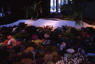
Slide, Robin Boyd, 1967
Robin Boyd was appointed Exhibits Architect for the Australian Pavilion at Expo ‘67 in Montreal. The garden outside the pavilion featured a sculptural pool, a coral display, animal pool, a pit for kangaroos and Eucalypts and other native plants. The indoor exhibits covered aspects of Australian art and culture, architecture, industrial design and scientific innovation, such as the Snowy Mountains Hydro-Electric Power Scheme, the Parkes radio telescope, the design of Canberra, and the Australian way of life. The coral display was prepared by E Grant, a fisheries research biologist.Colour slide in a mount. Coral display depicting the Great Barrier Reef, Australian Pavilion, Montreal Expo '67, Canada. Made in Australia / 17 / MAY 67M6 / 6 (Handwritten with red pen) / 10 (Handwritten)expo 67, montreal, robin boyd, slide -
 Hume City Civic Collection
Photograph
'Glenara' is situated along the Deep Creek at Bulla and was built on an original government grant of land by Walter Clark. His fourth child, Alistair, spent much of his life there and with the help of his gardener, W.Peers, gained world recognition for introducing 150 new rose species which included the Black Boy and Lorraine Lee. He was also founder of the Moonee Valley Racing Club.A black and white photograph of a Victorian home with a return verandah across the front and side. Vines are growing up the metal verandah posts and across the front of the verandah.glenara', rose gardens, roses, clark, alistair, walter, moonee valley racing club, george evans collection -
 Hume City Civic Collection
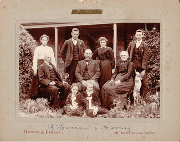
Photograph, The Duncan family, c1907
Back row from L- R: Rachael Barr, George Duncan, Margaret Grant, James Burnside. Middle row from L-R: George Duncan, John Duncan, Marion Duncan nee Burnside. Front row from L-R: Helen Davenport and Lilian Duncan. The photograph was taken outside 'Glencoe' at Diggers Rest with the family dog included,.A photo of the Duncan family posed in the garden of their house with a backdrop of the verandah. The group comprised of an elderly gentleman, a middle-aged man, a middle-aged woman, 2 young women, 2 young men and 2 girls. The dress is consistent with fashion of the late 19th century. People identified as: back row (L to R): Racheal Barr, George Duncan, Margaret Grant, James Burnside. Middle row: George Duncan, John Duncan, Marion Duncan (nee Burnside). Front row: Helen Davenport, Lillian Duncan. Taken outside Glencoe - with the dog! The photo is mounted on a grey cardboard matt. There are pin holes centre top and bottom and an area with residual sticking tape stain.printed on face: "Matson and Frazer 264 Little Collins Street," Handwritten on face: "Mr Duncan and family"barr, racheal, duncan, george, grant, margaret, burnside, james, john, marion, davenport, helen, lillian, glencoe, eric boardman collection, matson and frazer, 1900s, george evans collection -
 Ballarat Tramway Museum
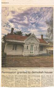
Newspaper, The Courier Ballarat, "Permission granted to demolish house", "Gregory Street house saved", "House returned home", May to June 2017
Set of three Newspaper clipping from The Courier, concerning the conservation of a the former Wendouree Gardens Gatekeepers cottage, that was relocated from 1414 Gregory St, by the City of Ballarat following its decision to firstly demolish, then agree to relocate and actually relocate. Each feature a photo of the cottage. The newspaper articles gives background, history and costs. Includes comments by the Friends of the Gardens and Councillors. .1 - "Permission granted to demolish house" - c May 2017 - photo by Lachlan Bence .2 - "Gregory Street house saved" - undated - cMay 2017 - article by Melissa Cunnigham .3 - "House returned home" - 28/6/2017 - photo by Jeremy Bannister, article by Jeremy Venosta.wendouree parade, gardens, houses, city of ballarat -
 Ballarat Tramway Museum
Map, Electric Supply Co. of Vic (ESCo), Ballarat Electoral Map - ESCo, 1900
Document prepared by the Electric Supply Co of Victoria, as part of an order under the Electric Light and Power Act 1896, section 5 of order No. 17 granted to company. Dated 19/2/1901 and signed by the Postmaster-General. Shows the order area being parts of the City of Ballaarat, Sebastopol and Ballarat East. Shows the street names, boundaries, principal power line routes, land reserves, parks, mine locations, railways and Lake Wendouree. Signed by R L Williams Town Clerk City of Ballarat, J R Hall for the Borough of Sebastopol, and John Gent for the Town of Ballarat EastYields information about the power supply to the Ballarat area.Cloth backed paper map, coloured and marked up as exhibit 17.Notes in ink including the signature of Benjamin Deakin 24/9/00 and certified by the three involved municipal Town Clerks.ballarat power supply, esco, electric supply co of victoria, city of ballaarat, east ballarat, sebastopol, orders, power lines, power supply -
 Ballarat Tramway Museum
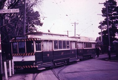
Slide - 35mm slide/s - set of 7, Noel Simons, 1970's
Set of 7 transparencies taken undated (appear to be 1970 or 71) on PAKON mounts. Also possibly copy slides as quality is poorish. 1175.1 - No. 27 has derailed at Depot, across Wendouree Parade, and No. 33 appears to be about to try and tow it back on. Wendouree Parade totally blocked. Adjacent pole has tram stop sign and has "Stafford Court" street sign mounted on it. 1175.2 - No. 43 at corner of Drummond St. South and Dana Street, with destination Lydiard St. North. 1175.3 - No. 42 (Mt Pleasant) and 21 (Gardens via Sturt St. West) crossing at Gardens Loop. 1175.4 - No. 42 bound for Lydiard St. Nth at intersection with Macarthur St. Shows the retaining wall for the cutting on the east side of Lydiard St. Nth. 1175.5 - No. 43 at corner of Lydiard St and Sturt St., at city terminus showing "Special" and tram 35 adjacent to Post Office in Lydiard St. Nth. Photo shows the small tram stop pole at this location and Post Office building. 1175.6 - No. 39 and 26 and 27 at the Mt Pleasant terminus. Near closure as a bus stop sign has been positioned on the west side of the road. No. 39 showing destination of "Gardens via Sturt St. West" 1175.7 - Nos 21 and 34 crossing at the Grant St. loop in Barkly St. 21 has destination of Mt Pleasant, while 34, - Gardens via Sturt St. West"All information on typed small white labels, on the top of the slides using black ink. 1175.1 - "27 derailed and 33 at depot" 1175.2 - "43 at cnr Drummond & Dana Sts" 1175.3 - "21 and 42 Gardens Terminus" 1175.4 - "42 at cnr Macarthur & Lydiard" 1175.5 - "43 & 35 at Post Office" 1175.6 - "39, 26 and 27 at Mt Pleasant" 1175.7 - "21 & 34 at Grant St"tramways, trams, wendouree parade, depot, accidents, derailments, drummond st. sth, gardens loop, post office, mt pleasant, grant st., tram 21, tram 26, tram 27, tram 33, tram 35, tram 42, tram 43 -
 Ballarat Tramway Museum
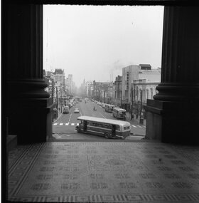
Photograph - Black & White Photograph/s, Geoff Grant, 16/06/1955 12:00:00 AM
View of Bourke Street Melbourne from just inside pillars of Parliament House looking west on 16 June 1955, a few days before the trams took over. MMTB Bus 580 turning into Bourke St from Spring St. Negative scanned hi res and imaged updated 20/5/2020.On rear in typed on paper "Buses inn Bourke St. A shot taken a few days before the trams took over. Taken from Parliament House steps 16 June 1955." & "Geoff Grant etc." stamp in btm rh corner.trams, tramways, melbourne, bourke st -
 Ballarat Tramway Museum
Photograph - Black & White Photograph/s, Geoff Grant, 25/06/1955 12:00:00 AM
Black & white photo of M&MTB tram No. 888 from rear cab of 877 while on AETA tour of 25/6/1955 in Victoria Street, North Richmond, just to the west of the North Richmond Station, Victoria Street railway bridge. Numerous parked cars of the era in the street, and shops on both sides of street. Tram 888 has destination of "SPECIAL", carrying AETA auxiliary board and a board on front dash of tram that says "ELECTRIC TRANSPORT A NECESSITY , PROTECTS YOUR INVESTMEST, BUILDS YOUR CITY, CREATES BUSINESS"On typed paper on rear, "Shot out of the Rear cabin of 877 showing 888 tailing us on AETA Bourke St. tour. June 25 1955" and "Geoff Grant" stamp in btm rh cnr.trams, tramways, victoria st, bourke st, aeta, north richmond , tram 888 -
 Ballarat Tramway Museum
Photograph - Black & White Photograph/s, Geoff Grant, 19/06/1955 12:00:00 AM
Black & white photo out of rear cabin of M&MTB tram No. 988, running "bang road" or wrong line in Bourke St. on Sunday, 19 June 1955 while testing overhead. Good view of Bourke St. buildings looking towards GPO. Some motor cars in the street. Negative No. 315 on file. Scanned image of negative btm497i1 shows a wider image than the print. Geoff Grant's notes on the envelope that contained the negative - says that this was the first tram to run on the Bourke St. route. Negative scanned at hi res 21/5/2020.On typed paper on rear "View out of the rear cabin of 988 as it came up Bourke St. on Sunday the 19 June 1955" and "Geoff Grant" stamp in btm rh corner.trams, tramways, melbourne, bourke st., commissioning , tram 988 -
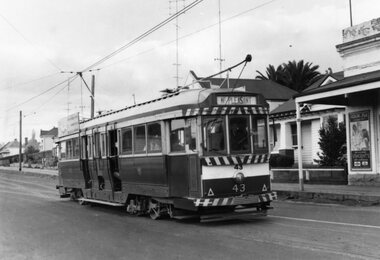 Ballarat Tramway Museum
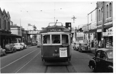
Photograph - Black & White Photograph/s, The Courier Ballarat, 5/09/1971 12:00:00 AM
Yields information about the tramcars and the street scenes at particular locations and how the tramway fitted with its streetscape at the time with a crossing loop behind the tram.Black and White copy photograph of a newspaper photograph taken by The Courier - unpublished, probably Sept. 1971 of No. 43 in Barkly St Mt Pleasant (could have been taken on the same date as Reg. Item 3769). Has the Grant St loop in the background. On the right hand side is a shop with a "Vincent's Cold and Flu" poster. See Reg Items 2907 for the actual newspaper cuttings. Collected by Alan Bradley from the Ballarat Courier early 1980's. See Excel file "Record of Ballarat Courier Photos SEC era" (Archive Documents) for source of details.On rear stamped "Copyright, The Ballarat Courier Proprietary Limited."tramways, trams, mt pleasant, barkly st, grant st, tram 43 -
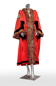 Bayside Gallery - Bayside City Council Art & Heritage Collection
Ceremonial object - Robe, Ede and Ravenscroft et al, City of Brighton Mayoral Robe, c. 1970
The City of Brighton Mayoral robe features embroidered Coat of Arms on the sleeves, which were granted in 1970 by the British College of Heraldry. It includes two figures, the market gardener heralding back to Brighton’s early history in farming, and an aboriginal man, symbolising the original inhabitants of the area, the Bunurong people of the Kulin Nation. This robe was worn by the City of Brighton Mayor until Brighton’s amalgamation into City of Bayside in 1993.Full length mayoral robe with centre opening. Red wool with light brown fur edging on centre front opening and cuffs. The cuffs are also trimmed with wide bands of black velvet and each shoulder has an embroidered polychromatic roundel featuring the Brighton Coat of Arms. The bottom edge of the robe also has black velvet trim. city of brighton, mayoral robe, robe, ceremonial wear, coat of arms, r.w. bredin & son, ede and ravenscroft, bayside, mayoral regalia -
 Kew Historical Society Inc
Album, Eva Grant, Historic Buildings in Victoria & New South Wales, 1919-c.1962
One of three scrapbooks created by Eva Grant, a past member of the Kew Historical Society which were donated by her niece, Julie Thomson, in 2013. The scrapbook includes photographs and descriptions of the following sites. (Many of these are now demolished and so the photographs and descriptions may be rare records of a site.) Sites include: Abbotsford (Vic) - Abbotsford Convent, Mayfield (c.1962), prefabricated house - Church street Armadale (Vic) - church (c.1959) - Thomson & Wattletree Roads Arthur’s Seat (Vic) - McCrae homestead Ballarat (Vic) - Memorial plaque on site of Bentley’s Hotel, Memorial on site of Eureka Stockade, Early municipal buildings - East Ballarat, Adam Lindsay Gordon’s cottage - Botanical Gardens, View from Sovereign Hill, Shell house Broken Hill (NSW) - panorama (1963), Flying Doctor’s base (?1963) Eltham (Vic) - Hassell’s outdoor art gallery Essendon (Vic) - Niddrie Homestead and stables (1963) Geelong (Vic) - first Bishopscourt Hawthorn (Vic) - Convent (1930), The Hawthorns, Keilor plains (Vic) - pioneer homes, pioneer cemetery Kew (Vic) - Roseneath (1951), Tarring - Ruyton, Turinville, house - Foley street (c.1960). Malvern (Vic) - church Mount Ridley (Vic) - Summerhill Melbourne (Vic) - Old Brewery - Custom’s House Lane (1960), Customs House, Scott’s Hotel (1962), Western market (c.1960) Phillip Island (Vic) - Grave Toorak (Vic) - Mandeville Hall, Merna (sic) - Arthur Streeton’s house, Toorak House Wentworth (NSW) - Harvey’s Hotel, Sturt Memorial, Sturt’s Tree, Wentworth Gaol Williamstown (Vic) - Williamstown Dairy Yan Yean (Vic) - Bear’s Castle (c.1947) Beveridge/Big Hill (Vic) - Kelly’s cottageImportant photograph record (and notes) about historic buildings in Victoria.38-page scrapbook with additional text created by Eva Grant, a past member of the Kew Historical Society. In addition to the 68 photographs, there are two postcards and a number of publications/handouts.collected by Eva on her trips to heritage sites in Victoria and New South Wales. The pages of the album can be viewed in the image carousel above. Most of the photographs of heritage buildings were taken in the early 1960s.See imagesheritage sites - victoria - australia, eva grant, scrapbooks - 20th century -
 Port Fairy Historical Society Museum and Archives
Photograph
Thomas and Margaret Maria Bermingham came to Australia from County Kildare in 1854. By 1856 Thomas was doing business as a Shoemaker in a three roomed dwelling with workshop and garden in Bank street. The stone hotel building was erected in 1867, and named Bermingham’s Victoria Hotel where he conducted the business with his wife. Thomas Bermingham died suddenly in 1874 only 48 years old. His wife continued to run the hotel until 1901. It was not unusual for women to run hotels at this time, although they had to be widowed To be granted a license.. John Maloney took up the license but the hotel closed in 1909. The building still stands and has been renovated Photograph of a building in Bank Street possibly the late 1800'sBlack and white photograph of weatherboard building with two multi panel windows 2 females and 2 males on footpathhotel, building, bermingham, bank street, john maloney -
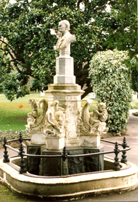 Friends of Ballarat Botanical Gardens History Group
Work on paper - Claxton Monument Conservation Grant, Claxton Monument Restoration, Ballarat Botanical Gardens
john garner collection, ballarat botanical gardens, gardens, ballarat, claxton, monument, restoration -
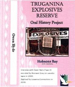 Truganina Explosives Reserve Preservation Society Inc (TERPS)
Digitised Oral History – Truganina Explosives Reserve - Tape 3 Owen Hyde, 2018
The interviews were recorded in 2000 by Bronwen Gray and Alan Young for the production of Unreserved, Stories from Truganina Explosives Reserve, animated stories from past residents, workers and interested people of the Reserve (subject to copyright 2004). Owen and Clive Hyde are the sons of Joe and Joyce Hyde. Joe was the last Officer in charge of the Truganina Explosives Reserve. The family moved to the reserve on 11 December 1952 and continued to live there after the Reserve closed in 1962. Owen lived at the house until his early twenties. He discusses growing up at the Reserve. The voice of Joyce Hyde can also be heard during the interview. A primary source of information on memories of the Truganina Explosives Reserve and Altona,VictoriaDigital copy of original cassette recorded in 2000 and digitised in 2018hobsons bay, draught horses, explosives reserve pier, myxomatosis, pine trees, queen street altona, edwardian garden, government superintendent houses, mcdonald, commonwealth bank, dr john lewin, altona, summer of the seventeenth doll, leslie george hyde, joe hyde, george grant, clive hyde, williamstown technical, mrs cronin, angus and robertson, pier fire, dutch migrants, communist party, laboratory, brass nails -
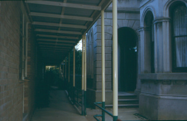 Kew Historical Society Inc
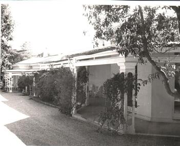
Slide - Hospital wing and Villa Alba entrance porch, 1987–2001
Built for William and Anna-Maria Greenlaw in the early 1880s, and with interiors decorated by the Paterson Bros, Villa Alba remained in private ownership until 1949. From 1950, the house was owned by a number of institutions. By 1984, the Villa Alba Preservation Society had been formed, and three years later, the Mount Royal Hospital granted a 25-year lease to Kew Council. In 2004, the title to Villa Alba was passed by the Victorian Government to The Villa Alba Museum Incorporated. Digital copy of a oolour 35mm slide, framed in a plastic mount, of the entrance to Villa Alba, 44 Walmer Street, Kew, 3101. The transparency shows the grey rendered tower, viewed from the east, looking west. At this stage a wing of the hospital abutted the south facade. The hospital wing was subsequently demolished and a Victorian era garden reinstated based on an original plan."Villa Alba exterior"villa alba museum, historic houses -- kew (vic.), victorian architecture -- melbourne (vic.), mount royal hospital -
 Kew Historical Society Inc
Slide - Hospital wing and Villa Alba's south-facing facade, 1987–2001
Built for William and Anna-Maria Greenlaw in the early 1880s, and with interiors decorated by the Paterson Bros, Villa Alba remained in private ownership until 1949. From 1950, the house was owned by a number of institutions. By 1984, the Villa Alba Preservation Society had been formed, and three years later, the Mount Royal Hospital granted a 25-year lease to Kew Council. In 2004, the title to Villa Alba was passed by the Victorian Government to The Villa Alba Museum Incorporated. Digital copy of a olour 35mm slide, framed in a plastic mount, of the entrance to Villa Alba, 44 Walmer Street, Kew, 3101. The transparency shows the grey rendered portico, viewed from the west, looking east. At this stage a wing of the hospital abutted the portico. The hospital wing was subsequently demolished and a Victorian era garden reinstated based on an original plan."Villa Alba ext"villa alba museum, historic houses -- kew (vic.), victorian architecture -- melbourne (vic.), mount royal hospital -
 Kew Historical Society Inc
Slide - Hospital wing and Villa Alba's south-facing facade, 1987–2001
Built for William and Anna-Maria Greenlaw in the early 1880s, and with interiors decorated by the Paterson Bros, Villa Alba remained in private ownership until 1949. From 1950, the house was owned by a number of institutions. By 1984, the Villa Alba Preservation Society had been formed, and three years later, the Mount Royal Hospital granted a 25-year lease to Kew Council. In 2004, the title to Villa Alba was passed by the Victorian Government to The Villa Alba Museum Incorporated. Digital copy of a olour 35mm slide, framed in a plastic mount, of the entrance to Villa Alba, 44 Walmer Street, Kew, 3101. The transparency shows the grey rendered portico, viewed from the east, looking west. At this stage a wing of the hospital abutted the portico. The hospital wing was subsequently demolished and a Victorian era garden reinstated based on an original plan."Villa Alba ext"villa alba museum, historic houses -- kew (vic.), victorian architecture -- melbourne (vic.), mount royal hospital -
 Kew Historical Society Inc
Slide - Hospital wing and Villa Alba portico, 1987–2001
Built for William and Anna-Maria Greenlaw in the early 1880s, and with interiors decorated by the Paterson Bros, Villa Alba remained in private ownership until 1949. From 1950, the house was owned by a number of institutions. By 1984, the Villa Alba Preservation Society had been formed, and three years later, the Mount Royal Hospital granted a 25-year lease to Kew Council. In 2004, the title to Villa Alba was passed by the Victorian Government to The Villa Alba Museum Incorporated. Digital copy of a oolour 35mm slide, framed in a plastic mount, of the entrance to Villa Alba, 44 Walmer Street, Kew, 3101. The transparency shows the grey rendered portico, viewed from the west, looking east. At this stage a wing of the hospital abutted the portico. The hospital wing was subsequently demolished and a Victorian era garden reinstated based on an original plan."Villa Alba ext"villa alba museum, historic houses -- kew (vic.), victorian architecture -- melbourne (vic.), mount royal hospital -
 Eltham District Historical Society Inc
Photograph - Digital Photograph, Alan King, Alistair Knox Park, Eltham, 2008
Alistair Knox Park, an oasis of peace and beauty. Covered under National Trust of Australia (Victoria) Landscape Significance and Heritage Overlay, Nillumbik Planning Scheme. Published: Nillumbik Now and Then / Marguerite Marshall 2008; photographs Alan King with Marguerite Marshall.; p173 It is hard to imagine that the Alistair Knox Park, an oasis of peace and beauty beside busy Main Road, Eltham, was once the township’s rubbish dump. It was only in the 1970s that the tip was transformed into this beautiful six hectare space, which later earned it a National Trust Landscape classification. Before its life as a dump, the area was used for small farms. Thanks largely to the foresight and efforts of local environmental builder Alistair Knox, the park was designed sympathetically with the character of the wider Eltham landscape. Then, appropriately, the park was named after Knox, who was an Eltham Shire Councillor from 1971 to 1975 and Shire President in 1975. The park designers were four major forces in the urban bush landscape garden –Knox, landscape designer Gordon Ford, artist Peter Glass and landscaper Ivan Stranger. The National Trust citation for the park, originally called Eltham Town Park, includes the Eltham railway trestle bridge and the Shillinglaw Cottage. The citation states ‘the semi-natural setting of the parkland provides a landscape which is evocative of the history of the area’. Manna Gums (Eucalyptus viminalis) and Candlebarks (Eucalyptus rubida) are significant features. Most of the park’s construction was directed by Bob Grant, Superintendent of the Parks and Gardens Department for the Eltham Shire Council. First plantings occurred in Arbour Week in 1973, then the lake and botanic area were completed in 1975, with Federal Government funding, and the toilet block in 1978. Bounded by the Eltham railway line, Panther Place, Main Road, Bridge and Susan Streets, the park is in a valley about a kilometre wide overlooked by steep hills at the east and west. The Diamond Creek flows through it and the picturesque historic timber trestle railway bridge edges the north. Informal plantings of Australian indigenous and native species in open and undulating grassed settings blend with the natural landscape of the Diamond Creek to the west. The bush-style plants, particularly around the creek, balance with open lawns, paths and a cascade flowing from a small lake to another below. A footbridge over the creek leads to the park’s west. The park includes an adventure playground and barbecue areas. The park stands on part of the land bought from the Crown in 1851 by Josiah Holloway, who subdivided it into allotments and which he called Little Eltham. Most of the land was subdivided into residential lots, but the creek valley, on which the park stands, was subdivided into farm-size lots, used mainly for orchards and grazing. One of the earliest owners was John Hicks Petty, who in 1874 bought a plot from Holloway. Other families who owned properties in that area, included Rees, Clark, Waterfall, Graham, Hill and Morant. In 1901 the railway was built through the area. Jock Read, an Eltham resident since around 1920, remembers several farms in the 1920s and ’30s that occupied the site of today’s park. A poultry farm, which extended from present day Panther Place, was owned by the Gahan family. Next to that farm was another for grazing cattle owned by Jack Carrucan. Beside this was land owned by John Lyon. A doctor lived beside this, and at the north-west corner of Bridge Street and Main Road stood a memorial to the soldiers who died in World War One, which was later moved to the RSL site. Mr Read also remembers other farms and orchards west of the creek In the early 1960s the Eltham Council began buying these farms and in the late 1960s turned the areas east of the Diamond Creek into a garbage tip. When this was filled above the creek’s flood plain, the tip was moved to the west of the creek.This collection of almost 130 photos about places and people within the Shire of Nillumbik, an urban and rural municipality in Melbourne's north, contributes to an understanding of the history of the Shire. Published in 2008 immediately prior to the Black Saturday bushfires of February 7, 2009, it documents sites that were impacted, and in some cases destroyed by the fires. It includes photographs taken especially for the publication, creating a unique time capsule representing the Shire in the early 21st century. It remains the most recent comprehenesive publication devoted to the Shire's history connecting local residents to the past. nillumbik now and then (marshall-king) collection, alistair knox park, eltham -
 Ringwood and District Historical Society
Document - Research Notes, Richard Carter, Land Subdivisions in Ringwood 1890-1950
Handwritten table listing main local pre-1950s subdivisions in the Ringwood area, with estate names, streets, number of allotments for sale, and where known, vendor agent, LP (Lodged Plan) title registration number, and auction/sale date, some with sale price.Pg1 RINGWOOD STATION ESTATE LP3070 (Year?) Station Street, William Street (now Kendall Street), Wantirna Road, Station Street Pg1 RINGWOOD TOWNSHIP ESTATE LP5577 (1913) Station Road (now Warrandyte Road), Pratt Street (part now Aird Street), Whitehorse Road Pg2 RINGWOOD ORCHARD ESTATE LP4315 (1914) Brysons Road, Hillcrest Road, Anzac Avenue, Sulva Road Pg3 RINGWOOD RAILWAY ESTATE LP7522 (1918) Whitehorse Road (now Mount Dandenong Road), Dublin Road, Freeman Street, Patterson Street, Bona Street Pg4 THE RINGWOOD ESTATE LP7578 (1919) Warrandyte Road, Hobart Street, Paxton Street, Arnold Street Pg5 GARDEN FARMS ESTATE (LP?) (1919) Canterbury Road, Armstrong Road, Bungalook Road, Orchard Road, Bayswater Road (now Mountain Highway) Pg6 THE RINGWOOD ESTATE (SECOND SUB-DIVISION) LP7604 (1919) Warrandyte Road, Tamar Street, Derwent Street, Mersey Street Pg7 RINGWOOD STATION ESTATE LP7703 (1919) Bedford Road, Williams Grove (now Lena Grove) Pg8 RINGWOOD TOWNSHIP ESTATE LP8198 (1919) Wantirna Road, Ellison Street, Haig Street, Greenwood Avenue Pg9 EASTFIELD ESTATE (LP?) (1920) Eastfield Road, Longview Road, Pleasant Rise, The Mount Pg10 ELECTRIC RAILWAY ESTATE RINGWOOD LP9473 (1922) Campbell Street, Myrtle Avenue, George Street (now Tudor Court), Henry Street (now Myrtle Avenue), Williams Grove (now Lena Grove) Pg11 RINGWOOD PARK ESTATE LP7884 (1922 - two stages) Wonga Road (now Loughnan Road), William Street, Andrew Street, Harrison Street Pg12 HEATHMONT STATION ESTATE LP11009 (Date? - after 1922) Lisgoold Street, Viviani Crescent, Balrour Avenue, Station Street (now part Heathmont Road and part Wainui Street) Pg13 RINGWOOD RAILWAY ESTATE LP10507 (1923) Whitehorse Road, Sherbrooke Avenue, Burwood Avenue, Bonview Avenue, Heatherbrae Avenue, Grant Crescent Pg14 GARDEN HOMES ESTATE (LP?) (1923) Mullum Road, The Centreway, Wattle Crescent (now Wattle Avenue) Reserve Crescent (now Reserve Road) Pg15 DUBLIN ROAD ESTATE LP11993 (1923) Alexandra Road, Vonadawn Avenue, Green Street, Wood Street, Howard Avenue, Bedford Road, Dublin Road Pg16 CARLINGA ESTATE RINGWOOD LP9620 (1923) Bourke Street, Bond Street, Ringwood Street Pg17 PRATT'S JUNCTION ESTATE (LP?) (1923) Junction Street, Georges Road, Oliver Street, Whitehorse Road Pg18 EAST RINGWOOD ESTATE LP10492 (1923) Bona Street, Patterson Street, Miller Grove, Fairview Avenue, Eastfield Road, Whitehorse Road (now Mount Dandenong Road) Pg19 COLEMAN'S HEATHMONT ESTATE LP9974 (1923) Canterbury Road, Bedford Road, Alvena Crescent, Coleman Street, Leonard Street (now Royal Avenue) Pg20 RINGWOOD HEIGHTS ESTATE LP10506 (1924) Whitehorse Road, Bonview Avenue, Grant Crescent, Hillcrest Avenue, Heatherbrae Avenue, Margaret Street, Mary Street Pg21 EAST RINGWOOD STATION ESTATE LP10551 (1924) Knaith Road, Wenwood Street, Lois Street, Victoria Street, Station Street (now Railway Avenue) Pg22 GRAND VIEW ESTATE LP11019 (1924) Whitehorse Road, Rupert Street, Herbert Street, Leonard Street Pg23 RINGWOOD RAILWAY ESTATE & RINGWOOD HEIGHTS ESTATE - FINAL SECTIONS LP10506 & LP10507 (1924) Whitehorse Road, Sherbrooke Avenue, Burwood Avenue, Bonview Avenue, Heatherbrae Avenue, Margaret Street, Mary Street, Grant Crescent Pg24 RINGWOOD EAST ELECTRIC STATION ESTATE (LP?) (1924) Railway Parade (now Patterrson Street), Federal Road, Howship Avenue (part now French Street), Dublin Road, Rosedale Crescent Pg25 BEDFORD PARK (now Ringwood Secondary College) (LP?) (1924) Bedford Road, Adams Street, Anderson Street, Joyce Street, Graham Road Pg26 CROWN JEWEL ESTATE LP11645 (Private sales after 1924) Mount Dandenong Road, Mirabel Avenue, Valda Avenue, Evon Avenue, Velma Grove Pg27 GRAND CENTRAL ESTATE LP10917 (1925) Heathmont Road, Great Ryrie Street, Douglas Street, Garden Street, Bellevue Avenue Pg28 RINGWOOD (unnamed estate - 1926) Nelson Street, Seymour Street, Whitehorse Road Pg29 EAST RINGWOOD RAILWAY STATION ESTATE (YEAR? - 25 shops 60 villas) Railway Avenue, Dublin Road, Lawrence Grove, Stanley Avenue, Knaith Road Pg30 CHARM VIEW ESTATE (LP?) (year? - after 1926) Canterbury Road, Heathmont Road, Dickasons Road, Bennjett Avenue, Orchid Street Pg31 SUNBEAM ESTATE LP12150 (Circa 1925) Govt Road (now Old Lilydale Road), Sunbeam Avenue, Holland Road, Everard Street (now Everard Road) Pg32 FAIRVIEW ESTATE EAST RINGWOOD LP10853 (Circa 1924) Eastfield Road, Patterson Street, Margaret Street (now Short Street) Pg33 EAST RINGWOOD TOWNSHIP ESTATE LP3025 (Circa 1924 - 35 allotments) Mount Dandenong Road, Grey Street, Eastfield Road Pg34 EAST RINGWOOD TOWNSHIP ESTATE LP3025 (Circa 1924 - 49 allotments) and STATE SCHOOL ESTATE (26 allotments) and EAST RINGWOOD STATION ESTATE (14 shop sites) Mount Dandenong Road, Grety Street, Dunn Street, Eastfield Road, King Street, Holland Road, Dublin Road, Patterson Street, Bona Street Pg35 EAST RINGWOOD CENTRAL ESTATE LP17004 (1948) Knaith Road, Shasta Avenue, Talofa Avenue, Russet Road, Dublin Road Pg36 WARE ESTATE LP43360 (1958) Ware Crescent, Davey Drive, Grey Road (now Grey Street), Mount Dandenong Road Pg37 Lot 57 Kendall Street LP3070 (1939) £75.0.0 Pg37 Lot 14 LP7346 (year?) £225 Pg37 Lot 8 WHITE HORSE ESTATE LP14010 (year?) Maroondah Hwy, Seymour Street £98.9.0 Pg37 Lots 4-14 incl. LP10902 (year?) £300 Pg37 Lots 69&70 LP2216 (1939) Bedford Road, Pitt Street £500 Pg37 Lots 60&70 LP2216 (year?) £460 Pg37 MOUNTAIN VIEW ESTATE LP10902 (1936) Lots 1&2, 19-22 Wantirna Road, Daisy Street £50 Pg38 RAILWAY STATION ESTATE RINGWOOD EAST LP7522 (1925) Lots 16 to 19 £250 Pg38 RINGWOOD PARK ESTATE (LP?) (1924) Lot 112 Munro Street £230 Pg38 RINGWOOD TOWNSHIP ESTATE (LP?) (1925) Lot 57 Wantirna Road £850 Pg38 ELECTRIC RAILWAY ESTATE LP9473 (1925) Lot 98 & 99 £180 (30/- foot) Pg38 ELECTRIC RAILWAY ESTATE LP9473 (year?) Lot 100 £233.12.6 incl improvements (£2.12.6 foot) Pg38 Lot 22&23 Bedford Road Heathmont (LP & year?) £675 incl improvements Pg39 Lot 9 Mullum Mullum Road LP8221 (1923) £150 Pg39 Lot 27 Haig Street LP8198 (1925) £825 Pg39 Lot 56 Haig Street cnr Wantirna Road LP8198 (1923) £171 Pg39 Lots 3 & 4 Loughnan Road LP9626 (192?) £147 Pg39 Lots 98 & 99 Myrtle Avenue LP9473 (1925) £180 Pg39 Lots 80 & 81 Myrtle Avenue LP9473 (1929) £150 Pg39 Lot 30 Sherbrooke Avenue LP10507 (1926) £700 incl improvements Pg40 Lot 10 (year?) LP7703 £750 Pg40 Lot 36 (year?) LP7522 £25 Pg40 Lot 38 Pitt Street LP2216 (year?) £350 Pg40 Lot 7 Dublin Road cnr Green Street LP11993 (year?) £300