Showing 101 items matching "great extended hustlers."
-
 Bendigo Historical Society Inc.
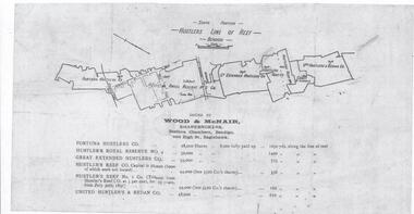
Document - Hustlers Line of Reef, Bendigo, South Portion, April, 2014
... Great Extended Hustlers...Seven men were killed at the Great Extended Hustler's mine...'. Fortuna Hustlers Co., Hustlers Royal Reserve No 2; Great Extended...Seven men were killed at the Great Extended Hustler's mine ...Seven men were killed at the Great Extended Hustler's mine disaster on 2nd May 1914 by an explosion of dynamite occurring as the men were waiting at the plat to ascend the mine at the end of their shift. No blame was attached to anyone in the findings of the inquisition. It was unknown what caused the dynamite to explode. This document formed part of the research done at the time by Bendigo Historical Society, of the 100 years commemoration of the mine disaster, held at Hustler's Hill in 2014. One page photocopy of plan of mining leases on the south portion of the Hustlers Line of Reef. Written underneath plan 'Wood & McNair, Sharebrokers, Beehive Chambers, Bendigo'. Fortuna Hustlers Co., Hustlers Royal Reserve No 2; Great Extended Hustlers Co., Hustlers Reef Co., Hustlers Reef No. 1 and United Hustlers & Redan Co. showing shares held and length of lease are listed on page. great extended hustlers, goldmining, accident, 1873 -
 RSL Victoria - Anzac House Reference Library and Memorabilia Collection
Photographs and Letters of Frederick George & Mary Jane BOXALL
... great extended hustlers mine... of the shaft after the accident at Great Extended Hustlers"... photographs letters great extended hustlers mine shell shock Hustlers ...George Frederick Boxall (1051 8th Battalion H Company), a miner from Bendigo, embarked from Melbourne on board Transport A24 Benalla on 19 October 1914. He returned to Australia on 8 May 1916, having suffered "shell shock" from a bomb blast on Gallipoli in September 1915.Hustlers Mine photograph inscribed on rear : "at the mouth of the shaft after the accident at Great Extended Hustlers"ww1, george frederick boxall, mary jane boxall, mary jane johnson, william henry johnson, 8th battalion, linton percy clarence rudd, allan tathorn moffat, robert carter, photographs, letters, great extended hustlers mine, shell shock -
 Bendigo Historical Society Inc.
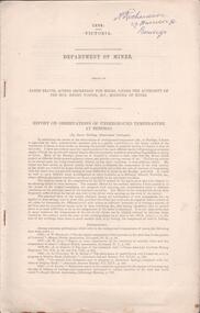
Document - Regulation of Mines Bill, famous mines of Bendigo, April, 2014
... Great Extended Hustlers...Seven men were killed at the Great Extended Hustler's mine... No. 1, Hustlers Reef, Great Extended Hustlers (formed 4.2.1865...Seven men were killed at the Great Extended Hustler's mine ...Seven men were killed at the Great Extended Hustler's mine disaster on 2nd May 1914 by an explosion of dynamite occurring as the men were waiting at the plat to ascend the mine at the end of their shift. No blame was attached to anyone in the findings of the inquisition. It was unknown what caused the dynamite to explode. Three page typed document. First page: 'The Regulation of Mines Bill' by Albert Richardson; Angus Mackay, Minister of Mines introduced the Bill in the Legislative Assembly on October 16th 1873 and it became law on January 1st 1874. Second page: 'Famous Gold Mines of Bendigo and Eaglehawk' by Albert Richardson, discusses deep shafts, more than 4000 feet shafts, wages for 1911. Hustler's Line of Reef mines are listed from north to south: Hustler Consols; United Hustler's and Redan, K.K., Comet, Hustler's Reef No. 1, Hustlers Reef, Great Extended Hustlers (formed 4.2.1865) Hustler's Royal Reserve Co., (Park Shaft) Hustler's Royal Reserve (City Shaft) and Fortuna Hustler's (formed August 1888).great extended hustlers, goldmining, accident, quartz, mining, k.k. mine, comet mine, hustler's line of reef, old comet, united hustler's, redan -
 Bendigo Historical Society Inc.
Document - Geological Survey of Victoria, Hustlers Line of Reef, Bendigo, April, 2014
... Great Extended Hustlers...Seven men were killed at the Great Extended Hustler's mine... and bowling green; a plan of the Great Extended Hustler's Shaft...Seven men were killed at the Great Extended Hustler's mine ...Seven men were killed at the Great Extended Hustler's mine disaster on 2nd May 1914 by an explosion of dynamite occurring as the men were waiting at the plat to ascend the mine at the end of their shift. No blame was attached to anyone in the findings of the inquisition. It was unknown what caused the dynamite to explode. This document formed part of the research done at the time by Bendigo Historical Society, of the 100 years commemoration of the mine disaster, held at Hustler's Hill in 2014. Seven page photocopy of Department of Mines, Bulletin, Geological Survey of Victoria, Hustlers Line of Reef, Bendigo, No. 33 by H.S. Whitelaw. Includes plan of Hustlers Royal Reserve No. 2, (main shaft) showing location on Pall Mall, and location of Post Office and Law Courts; plan of location of Hustlers Royal Reserve No. 2 (Park Shaft) showing Jail (sic), Camp Hill State School, two 'lagoons' in between tennis court, croquet court and bowling green; a plan of the Great Extended Hustler's Shaft and two copied images of Hustler's Hill showing mining buildings, poppet heads and chimneys. Comet, K.K., Hustler's No. 1, Old Comet and United Hustler's and Redan Mines are shown in the images. great extended hustlers, goldmining, accident, quartz, mining, k.k. mine, comet mine, hustler's line of reef, old comet, united hustler's, redan -
 Bendigo Historical Society Inc.
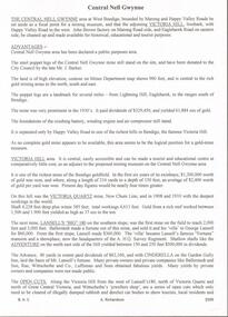
Document - THE AUSTRALIAN SKETCHER - THE GOVERNOR'S VISIT TO SANDHURST
... Great Extended Hustlers Mine... to the Great Extended Hustlers Mine by His Excellency and party.... Captain Josephs Great Extended Hustlers Mine Mrs Francis Mr Carr ...Detailed, handwriten account of the Governor's Visit to Sandhurst in 1873. It includes the day's activities and a visit to the Great Extended Hustlers Mine by His Excellency and party.document, the australian sketcher, the governor's visit to sandhurst, mr d mcdougall, sir george ferguson bowen kcmg, lady bowen, sir hercules robinson, lady robinson, miss robinson, miss bowen, cr aspinall, cr allingham, cr bayne, cr buckley, cr nall, cr hattam, cr clark, cr j holmes, mr fletcher, oddfellows, foresters, deutsche yerein, good templars, hibernians, st andrew's societies, druids, prince of wales light horse, captain moorhead, superintendent chomley, hallas's sandhurst band, shamrock hotel, bendigo rifles, captain josephs, great extended hustlers mine, mrs francis, mr carr, mr kay, corn exchange, bendigo hospital -
 Bendigo Historical Society Inc.
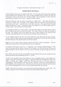
Photograph - EXTENDED HUSTLERS FREEHOLD
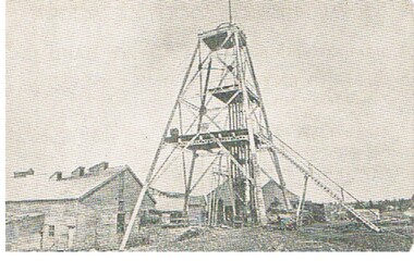
... great extended hustlers mine...black and white photograph of Great Extended Hustlers... ORGANIZATION Business great extended hustlers mine black and white ...black and white photograph of Great Extended Hustlers Freehold poppet head, now at Wattle Gully, Chewton ( james Lerk 26.22.1999 ) Poppet head in front of mining buildings, stacks of sawn timber tonight. Great Extended Hustlers/locality/Hustlers Hill Nth. Bendigo/ formed 1865/last production 1921. Depth of shaft 3,470 ( 1045 m ) Poppet legs, steel 70 feet high ( 21.08 ) Gold very rich, total yield 300,000 ozs. Dividends 675,000 pounds sterling ( $1,350,000 )organization, business, great extended hustlers mine -
 Bendigo Historical Society Inc.
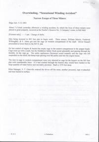
Document - The Flooded Mine, John McCaviston's Escape, April, 2014
... Great Extended Hustlers...Seven men were killed at the Great Extended Hustler's mine...Seven men were killed at the Great Extended Hustler's mine ...Seven men were killed at the Great Extended Hustler's mine disaster on 2nd May 1914 by an explosion of dynamite occurring as the men were waiting at the plat to ascend the mine at the end of their shift. No blame was attached to anyone in the findings of the inquisition. It was unknown what caused the dynamite to explode. Three page typed document by Albert Richardson. Copy of handwritten document. 'The Flooded Mine, John McCaviston's Wonderful Escape' by G. Mackay (History of Bendigo). Article details the events that surrounded the flooding that occurred at the Hustlers Reef Company's mine on 13th December 1873. Water was being drained from the adjoining old workings of Latham and Watson, when the flow increased markedly, causing flooding. John McCaviston was the 'shift boss'., R. Jackson the Manager. McCaviston was saved after spending over 20 hours in a level.3527.2 on bottom of all pages. Duplicate copy. great extended hustlers, goldmining, accident, quartz, mining, flooding of mine, john mccaviston, mine rescue, r. jackson, latham and watson -
 Bendigo Historical Society Inc.
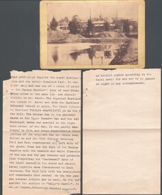
Document - Overwinding: Narrow Escape of Three Miners, April, 2014
... Great Extended Hustlers...Seven men were killed at the Great Extended Hustler's mine...Seven men were killed at the Great Extended Hustler's mine ...Seven men were killed at the Great Extended Hustler's mine disaster on 2nd May 1914 by an explosion of dynamite occurring as the men were waiting at the plat to ascend the mine at the end of their shift. No blame was attached to anyone in the findings of the inquisition. It was unknown what caused the dynamite to explode. One page typed document detailing the escape of three miners when a cage plunged to the 845 feet plat. William Merrin, Frederick Willoughby and E. Johns were the miners in the cage when the engine driver lost 'control of engine and hauled the empty cage in the eastern compartment to the poppet head' . On back of page, article on Unity Mine Fire on Tuesday 8th October, 1907. Louis Pabst, Conrad Inglefinger, Edward Fuller, Frederick Allen and William Whitford were miners at work when fire occurred. 3603.2 on bottom of all pages. Duplicate copy. great extended hustlers, goldmining, accident, quartz, mining, winding accident, overwinding, engine driver, s.t. glanville mine manager -
 Bendigo Historical Society Inc.
Photograph - WES HARRY COLLECTION: ROYAL HUSTLERS MINE, Early 1870's
... Great Extended hustlers tribute shaft..., with the Hustlers Extended behind it again. The Great Extended Hustlers... Imperial Hustlers Hustlers Extended Great Extended hustlers tribute ...Sepia toned photograph depicting the Royal Hustlers Mine and dam within Rosalind park, this was 1150' deep. (The mine, not the dam) Three other mines on the same line are clearly visible to the north. The Imperial Hustlers is behind the Hotel, with the Hustlers Extended behind it again. The Great Extended Hustlers Tribute shaft (1970') is on the far hill.topic, mining, hustler's, upper reserve dam, royal hustlers mine, imperial hustlers, hustlers extended, great extended hustlers tribute shaft, imperial hustlers hotel. -
 Bendigo Historical Society Inc.
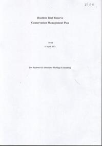
Document - HUSTLERS REEF RESERVE CONSERVATION MANAGEMENT PLAN
... great extended hustlers mine site... Great Extended Hustlers Mine site. Leigh McKinnons amendments...BENDIGO Mining great extended hustlers mine site ...Conservation management plan (112 pages) prepared by Lee Andrews & Associates, Heritage Consultants, in 2011, for the Hustlers Reef Reserve. The reserve cover the site of the former Great Extended Hustlers Mine site. Leigh McKinnons amendments to the plan are included with the document. History of the site, a physical survey and analysis, comparative analysis, cultural significance and conservation policy are addressed in the document.bendigo, mining, great extended hustlers mine site -
 Bendigo Historical Society Inc.
Document - VICTORIA HILL - SELF TOUR OF GOLDFIELDS NO 1
... Great Extended Hustlers... Reserve (City Mine), Great Extended Hustlers, The Hustlers Reef... Hustlers Hustlers Royal Reserve (City Mine) Great Extended Hustlers ...Two copies (a & b) of a Royal Historical Society of Victoria, Bendigo Branch Self Tour of Goldfields No 1. The guide is to enable the tourist to locate and see for himself some of the gold mining area of Bendigo. Mines mentioned are: Deborah, North Deborah, Central Deborah, The Fortuna Hustlers, Hustlers Royal Reserve (City Mine), Great Extended Hustlers, The Hustlers Reef, Lansell's Comet, The United Hustlers and Redan, Garden Gully United, Central Nell Gwynne, The Old Chum, The New Chum and Victoria, The Lazarus, The New Chum United, The New Chum Consolidated, The Garibaldi, Advance, Lansell's 180, The Victoria Quartz, North Old Chum, The Ironbark, The Hercules, The Carlisle United, The Mungo Group, The Ellenborough, The St. Mungo, The Lady Barkly, South St. Mungo. Notes also include wages at the Fortuna Hustlers in 1906 and 1907, gold yield, depth of shaft, Dividends and Calls. Notes compiled by Mr. A. Richardson.document, gold, victoria hill, self tour of goldfields no 1, deborah (big deborah), north deborah, central deborah, the fortuna hustlers, hustlers royal reserve (city mine), great extended hustlers, the hustlers reef, lansell's comet, the united hustlers and redan, garden gully united, central nell gwynne, the old chum, the new chum and victoria, the lazarus, the new chum united, the new chum consolidated, the garibaldi, advance, lansell's 180, the victoria quartz, north old chum, the ironbark, the hercules, the carlisle united, the mungo group, the ellenborough, the st. mungo, the lady barkly, south st. mungo, hustlers hill, new chum hill, jonathan harris, j hustler, messrs latham and watson, buckell & jeffrey, camp hill school, mechanics institute eaglehawk, duke of edinborough, geo lansell, the k k shaft, williamsons, little's claim, rosalind park, mr pryor, gold mines hotel, burrowes and sterry, bonatti, menzies, hildebrant and koch's, ellesmere, p m g repeater station, mr lazarus, mt alvernia hospital, mr clarke magee, rae's, jeweller's shop, hopetoun band room, manchester arms hotel, wattle gully mine chewton, long gully post office, 'pope pius' roman catholic church, kentish, mr j b watson, california gully state school, duke of edinborough, new st mungo, duchess tribute, south devonshire, duchess of edinborough, west united devonshire, united devonshire, princess alexandra, hopewell, miners' phthisis, bendigo goldfields, mr a richardson -
 Bendigo Historical Society Inc.
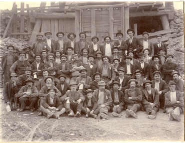
Photograph - GROUP OF WORKMEN IN FRONT OF C.I. BUILDING
... Great Extended Hustlers... in pencil ' given by Cyril Jacobs. Probably Great Extended Hustlers... and mining miners hustlers group Great Extended Hustlers mines mining ...Black and white photograph glued to cream board. Group of workmen standing and sitting in rows outside C.I. Building with wooden steps up to doorway. Three men in front row holding foot containers. One man sitting on ground at front holding engineer's hammer. Thirty men. In total. Inscriptions: on back- handwritten in pencil ' given by Cyril Jacobs. Probably Great Extended Hustlers. L Hocking, second from left in back row. W Bullen sitting in front facing left, night shift'. 'Historical Society of Vic, Bendigo Branch: hand-written in ink.person, mining, miners, bendigo, workers, workmen, mines and mining, miners, hustlers, group, great extended hustlers, mines, mining -
 Bendigo Historical Society Inc.
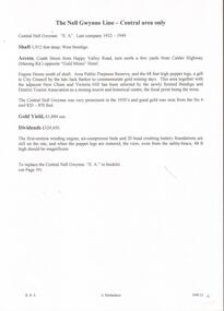
Document - CENTRAL NELL GWYNNE - NOTES ON CENTRAL NELL GWYNNE
... Great Extended Hustlers..., Great Extended Hustlers, Lazarus, Barnet Lazarus, United... Collman & Tacchi Great Extended Hustlers Lazarus Barnet Lazarus ...Handwritten notes and carbon copy on the Central Nell Gwynne Mine. Notes mention the depth of shaft, locality, gold yield and dividends. Also mentioned is the area selected by the Bendigo and District Tourist Association as a mining tourist and historical Centre. Also mentioned is the Hercules no 1, Pearl East, Hercules New Chum and the Carlisle. Also in the notes are alterations for a proposed booklet. It mentions Collman & Tacchi, Great Extended Hustlers, Lazarus, Barnet Lazarus, United Devonshire, West United Devonshire, Confidence Extended, Johnson's No 2, New Argus, South New Moon, Lansell's Comet and the Central Red, White and Blue. Images 3509.13a,13b,13c,13d,13e,13f,13g,13hdocument, gold, central nell gwynne, central nell gwynne, notes on central nell gwynne, bendigo and district tourist association, jack barker, hercules no 1, pearl east, hercules new chum, carlisle, collman & tacchi, great extended hustlers, lazarus, barnet lazarus, united devonshire, west united devonshire, confidence extended, johnson's no 2, new argus, south new moon, lansell's comet, central red, white and blue, baling of water -
 Bendigo Historical Society Inc.
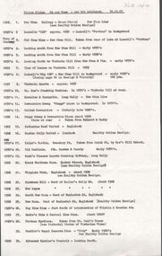
Document - MINING REPORTS -DEPARTMENT OF MINES, REPORT ON OBSERVATIONS OF UNDERGROUND TEMPERATURE AT BENDIGO
... Great Extended Hustlers..., Shamrock, Great Extended Hustlers, Princess Dagmar and United... Victoria Quartz Shamrock Great Extended Hustlers Princess Dagmar ...Printed Report on Observations of Underground Temperature at Bendigo, by James Stirling, Government Geologist. Report mentions temperature increases as the mines get deeper, temperature of air and rocks, Meteorological Observations at 180 Mine, Bendigo, comparison temperature in other parts of the world and Bendigo, Temperature of air at the 180 Mine, Shenandoah Mine, victoria Quartz, Shamrock, Great Extended Hustlers, Princess Dagmar and United Hustlers and Redan, Daily Variation of Temperature and Pressure of the Air, Temperature of Fault Line, Drawing of Lansell's No 180 Mine showing levels, geological features, graph of Curves of Atmosphere Pressure at 180 Mine Bendigo, graph of Curves of Temperature at 180 Mine Bendigo, Lansell's 180 Mine Rate of Aincrease of Rock Temperature, Comparisons with Observations in other Countries, Observations in November and December 1895, Meteorological Observations at New Chum Railway Mine Bendigo, Kiagram of working 'ends' showing temperatures therein at the New Chum Railway Mine Bendigo Vic, Additional Observations at Lansell's 180 Mine, Shamrock, Princess Dagmar, United Hustlers and Redan and Great Extended Hustler's, Humidity with formula which was adopted, Hygrometer Observations, The Ventilating Currents (and formula), Notes on Anemometer Records 180 Mine, Tabulated List showing Velocities of Air Currents at Various Levels in the 180 Mine Bendigo, Pressure of Air (and formula), Composition of the Air at Lansell's 180 Mine, Shamrock, Princess Dagmar, Gt Extended Hustlers and United Hustlers and Redan and Miners' Complaints. A Richardson name written on the top right corner.A. Richardson, 29 Harrison St., Bendigogold, mining reports, mining reports, report on observations of underground temperature at bendigo, department of mines, james travis, the hon henry foster, james stirling, 180 mine, shenandoah mine, victoria quartz, shamrock, great extended hustlers, princess dagmar, united hustlers and redan, new chum railway mine, north old chum, m grehauf, dr boyd, robt s brain -
 Bendigo Historical Society Inc.
Document - LONG GULLY HISTORY GROUP COLLECTION: HUSTLERS LINE OF REEF
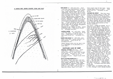
... Great Extended Hustlers... Shafts, Great Hustlers, Latham, Watson, Great Extended Hustlers... Harris Latham and Watson Great Hustlers Great Extended Hustlers ...Page mentioning mines on the Hustlers Line of Reef. The are: Fortuna Hustlers, Royal Hustlers Reserve No 2 - City and Park Shafts, Great Hustlers, Latham, Watson, Great Extended Hustlers, Tribute or Pups Shaft, Bendigo's Worst Mining Disaster May 2 1914, Hustlers Reef (Old Hustlers) and Hustlers Reef No 1, Lansell's Comet Lightening Hill Line, The Old Comet (Cooper's Claim), United Hustlers and Redan, K K Shaft, North or New Hustlers (once known as Agnew Hustlers), Derby Line - Johnson's No 3, Paddy's Gully Line, Lansell's 'Sandhurst' (Needle), Needle Loops, Cleopatra Needle top, British American, Collman and Tacchi and South Virginia. Also mentioned is Total Gold Yield, Main Shafts on Field, Price of Gold (Old Currency) and Saddle Reefs and Spurs. Also mentioned are New Moon, Suffolk United, South New Moon and North New Moon. There is a diagram of a Saddle Reef, Centre Country, Spurs and Fault. Depth of shaft, machinery, location, dividends and yields are also mentioned. Price of Gold (Old Currency): 1851-1930, Price varied from Approx. £3/17/6 to £4 per ounce. 1938, from £6/19/10 to £7/8/10 per ounce. 1946/47/48 £10/15/3 per ounce, May 1, 1954 £15/12/6 per ounce.bendigo, history, long gully history group, the long gully history group - hustlers line of reef, fortuna hustlers, buckell & jeffrey's, railway goods sheds, rsl memorial hall, camp hill school, royal hustlers reserve no 2 - city and park shafts, jonathan harris, latham and watson, great hustlers, great extended hustlers, wattle gully mine, messrs j hustler latham and watson, tribute or pups shaft, bendigo's worst mining disaster, hustlers reef (old hustlers) and hustlers reef no 1, lansell's comet, the old comet (cooper's claim, united hustlers and redan, k k shaft, north or new hustlers (once known as agnew hustlers), derby line - johnson's no 3, pa ddy's gully line, lansell's 'sandhurst' (needle), needle loops, cleopatra needle top, british american, collman and tacchi, south virginia, saddle reefs and spurs, new moon, suffolk united, south new moon, north new moon -
 Bendigo Historical Society Inc.
Document - Hustlers, Sheepshead and Deborah lines of reef
... Great Extended Hustlers.... Great Extended Hustlers (1865-1921) close to intersection... Great Extended Hustlers Hustlers Reef No. 1 Lightning Hill line ...Albert Richardson was a mining historian who wrote widely on the mines of the Bendigo Goldfield. The park opposite the Goldmines Hotel in Marong Road, is named in his honour. Five page document, hand written by Albert Richardson on lined foolscap and edited with cross-outs and insertions, . The mines along the Hustlers line of reef and the Sheepshead line of reef are described. Mines listed on Hustlers line of reef: Fortuna Hustlers (1888 - 1913), shaft 2,240 feet at rear of Buckell and Jeffrey's offices; Royal Hustlers Reserve No. 2 - two shafts 'City" 860 feet, now covered by R.S.L. building Pall Mall, steel poppet legs 60 ft high and 'Park Shaft" at rear of Camp Hill School, 1,775 feet, steel poppet legs 60 feet high; Hustlers Hill Group first worked by Jonathan Harris in 1853 and bounded by Valentine, Anderson and Ironbark Creek to the north and Milroy Street to the east, one of first areas worked for quartz reefing. It with Garden Gully line west and Victoria Hill Ironbark, formed by far the richest cross section of the Bendigo Goldfield. Great Extended Hustlers (1865-1921) close to intersection of Anderson Street and Hustlers Road, mullock heap against road and shored up around shaft, steel poppet legs now at Wattle Gully mine, Chewton, large winding machine, air compressor south of shaft and 36 head crushing battery. Hustlers Reef (Old Hustlers) and Hustlers Reef No. 1, two shafts, main 2,210 feet, about 220 yards east of Moran Street and against Fenton Street. , No. 1 shaft 1,140 feet and about 155 yards east of Moran Street. Lansell's Comet, Lightining Hill line, 2.100 feet, on Comet Hill approx 70 yards west of Holmes Road, near Comet Creek, steel poppet legs. United Hustlers and Redan (1876-1918), main Redan, 1,830 feet about 155 yards west of Sandhurst Roead, in line with Comet Hill State School, this hill known as Redan Hill. North, or New Hustlers, once known as Agnew Hustlers, wooden poppet legs, south side, Kneebone Street, Eaglehawk. Derby line, Johnson's No. 3, South Johnson's (east shaft of Collman and Tacchi) 439 feet on west wide of Woods Street, south of Wetherall Street. Paddy's Gully Line, south to north, some shafts - Lansell's 'Sandhurst" ('Needle") Eaglehawk Road shaft 2,425 feet, about 50 yards east of Needle Loops, a brick square sided chimney with Cleopatra Needle top. British American, 789 feet, just south of Holdsworth Road. Collman and Tacchi, main shaft 2,588 feet, 60 yards west of Eaglehawk Road, California Gully. Deborah Line of Reef, The Deborah (1932-1954) shaft 2.017 feet, west of Adams Road and south of Abel Street, Quarry Hill. North Deborah (1937 - 1954) shaft 1,151 feet, Breen Street, Quarry Hill, steel poppet legs. Central Deborah (1939-1954) shaft 1,347 feet Sheepshead line of reef, Lansell's South Red, White and Blue, shaft 2,124 feet, north east of Bellevue Road and 220 yards east of Adams Road. The New Red, White and Blue Consolidated (Big Blue) main shaft 2,416 feet. Lansell's Bendigo Battery 105 head, north of 'Big Blue" on his freehold lease, commenced crushing on 24th February 1895. After closing was erected as the Showground's Industrial Hall, July 1926. North Red, White and Blue, burnt down February 1926, new company 1934, closed 1938. Document is part of the Albert Richardson Collection of Bendigo mining history. bendigo, gold mining, deborah line of reef, sheepshead line of reef, hustlers line of reef, royal hustlers reserve mine, hustlers hill group of mines, great extended hustlers, hustlers reef no. 1, lightning hill line, old comet, collman and tacchi, lansell's comet, north deborah, central deborah, dhrrpdhrsf linr og trrg, new red, white and blue consolidated mine, big blue, lansell's bendigo battery, north red, white and blue mine, albert richardson collection -
 Bendigo Historical Society Inc.
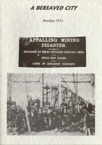
Book - A BEREAVED CITY, BENDIGO 1914 - EXPLOSION AT GREAT EXTENDED HUSTLER'S MINE, 2002
... A BEREAVED CITY, BENDIGO 1914 - EXPLOSION AT GREAT EXTENDED... MINING Miners' Safety Cage great extended hustler's accident ...A BEREAVED CITY, BENDIGO 1914 - EXPLOSION AT GREAT EXTENDED HUSTLER'S MINE. 66 pages with photos.John Kellygold mining, miners' safety cage, great extended hustler's accident, bendigo, gold mining, mining accidents, great extended hustler's mine -
 Bendigo Historical Society Inc.
Document - BENDIGO AND DISTRICT IN COLOUR
... Great Extended Hustlers... The Garden Gully New Chum Railway Great Extended Hustlers White Death ...''Bendigo and District in Colour'' Possible full title - see first page. (by Ken and Esther Stepenell). Seven paged very broad coverage of Bendigo's history and attractions. Includes mention of Dai Gum San Village (and proposed site??)Ken and Esther Stepenellbendigo, history, gold mining, bendigo creek, eaglehawk, peg leg, the garden gully, new chum railway, great extended hustlers, white death, chinese, joss house, sun loong dragon, victoria hill, whipstick forest, talking trams, dia gum san village. -
 Bendigo Historical Society Inc.
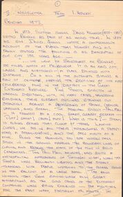
Document - BENDIGO 1873
... Great Extended Hustlers... David Kennedy David Kennedy Jnr Great Extended Hustlers Messrs ...David Kennedy(1825-1886) was a Scottish singer. Initially a church musician. HE had a large family many of whom were also singers and toured throughout the world. 1872-1876 the group toured Canada, New Zealand and Australia. In 1879 and 1880 they toured India and South Africa. In 1881 three of his children died in a fire at a Nice theatre. David died in South Africa but is buried in Scotland. David junior(1849-1885) began as a singer with his father but later moved into writing.Hand written account of Scottish singer David Kennedy and his family's World Tour, of which Bendigo was a part, written by David Kennedy Jnr. He tells of the mine in Pall Mall, the gold cakes from the different companies displayed in the bank windows, meeting some Chinese sifting tailings, buying a Chinese book and then finding it was an old almanac. Meeting two Irishmen and an account of a large public school. Some of the ink has run.document, bendigo 1873, david kennedy, david kennedy jnr, great extended hustlers, messrs smith and jones, david kennedy the scottish singer, marjory kennedy, alexander gardener -
 Bendigo Historical Society Inc.
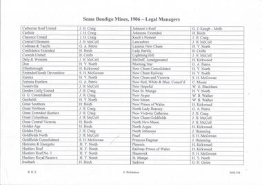
Document - MINING REPORTS - LIST OF LEGAL MANAGERS
... Great Extended Hustlers... Extended Hustlers Great Columbian Great Central Victoria Golden Age ...Handwritten list by Albert Richardson, with typed copy of same, of some Bendigo Mines and their Legal Managers, as at September 30th, 1906. Document is part of the Albert Richardson Collection. document, gold, miner's right, mining reports, list of legal managers, j h craig, j h mccoll, g a petrie, h birch, b crofts, h y north, h kirkwood, s h mcgowan, g j keogh, c moore, w g blackham, w b walker, j humming, g h green, catherine reef united, carlisle, clarence united, central ellesmere, collman & tacchi, confidence extended, cornish united, daly & westons, don, ellenborough, extended southdevonshire, eureka, fortuna hustlers, fosterville, garden gully united, g g consolidated, garibaldi, great southern, great northern, great extended hustlers, great columbian, great central victoria, golden age, golden pyke, goldfields north, goldfields consolidated, hercules & energetic, hustlers reef, hustlers reef no 1, hustler's royal reserve, ironbark, johnson's reef, johnsons extended, koch's pioneer, lancashire, lazarus new chum, lady barkly, lightning hill, mcduff amalgamated, morning star, new chum consolidated, new chum railway, new chum & victoria, new red white & blue consolidated, new hopeful, new st mungo, new argus, new moon, new prince of wales, north lady brassey, new victoria catherine, new chum goldfields north new moon, north argus, north johnsons, pearl, princess dagmar, phoenix, railway prince of wales, shamrock, st mungo, sadowa, sea, stewart's united specimen's hill, south st mungo, south new moon, south devonshire, suffolk united, south prince of wales, spring gully junction, true blue, thomas united, united devonshire, unity, united hustlers & redan, united ulster, victoria consols, victoria reef quartz, victory and pandora, virginia, victoria proprietory, williams united -
 Bendigo Historical Society Inc.
Document - MINING REPORTS - BENDIGO MINING REPORTS
... Great Extended Hustlers... Extended Hustlers Wattle Gully Mine Chewton Big Deborah Mine Royal ...Albert Richardson had a life long interest in Bendigo's mining. He wrote broadly about the practical aspects of mining and the history of many of the mining companies. One handwritten and typed copies (3 of page 1, 3 of page 2, 2 of page 3 and 2 of page 4). Notes, written by Albert Richardson, include an introduction which mentions the noise of the mining activities, all the machinery being made in Bendigo by the local foundries and the end of the mining.There are explanations of poppet legs or heads, landing brace, intermediate brace, safety brace, pulley wheels, boilers, winding engine, types of engines and air compressors.document, gold, mining reports, mining reports, bendigo mining reports, a. roberts & sons, h.harkness and coy, horsfield's, south new moon, central deborah, great extended hustlers, wattle gully mine chewton, big deborah mine, royal hustlers reserve no 2 shaft, the city, johnsons reef no 2, lansell's comet, south devonshire, great southern, victoria quartz, lansell's big '180', little '180', new moon, big blue, central blue, central nell gwynne, lansell's sandhurst or 'needle' mine, eureka extended -
 Bendigo Historical Society Inc.
Document - LONG GULLY HISTORY GROUP COLLECTION: HISTORICAL GUIDE TO BENDIGO
... Great Extended Hustlers... and Watson Great Hustlers Great Extended Hustlers J Hustler Latham ...Brochure with an invitation to visit Historical and Mining Museum in Mechanic's Institute, Eaglehawk. Drawing of poppet legs on the front with The Royal Historical Society of Victoria Bendigo Branch. Historical Guide to Bendigo including Self Tours of Bendigo's Famous Goldfields. Forward by John Hattam. Contributors are: H Biggs, Miss L J Parry, A Richardson, L C Bennetts and Edith Checcucci. Credits - The Bendigo Advertiser, Cambridge Press, Mines Department (Bendigo) and J R W Purves. Items include Bendigo Tramways Compiled by H Biggs, Early Bendigo Hotels Compiled by L C Bennetts, Eaglehawk Compiled by H Biggs, Noted Events Compiled by June Parry, The Bendigo Post Office Compiled by LC Bennetts, The Bendigo Goldfield. Introduction to Field and Guide to Some Famous Mines Compiled by A Richardson. Photos include: Pall Mall Bendigo, Ravenswood Homestead, An Early Battery at Kangaroo Flat, Historic High Street Golden Square, The Lonely Grave, Battery Tram c1888, Steam Tram c1892, Electric Tram c1903, The New Chum Railway Golden Square, United Hustlers and Redan Mine Sandhurst Road, Central Deborah Violet Street, Deborah Mine Quarry Hill, Deborah Mine 1000 ft level, First Motion Winding Engine at Central Deborah, Victoria Hill Area, and Looking south from New Chum Hill in 1890's. Also 11010.254, 255, 268, 288a, 288b, and 289.bendigo, history, long gully history group, the long gully history group - historical guide to bendigo, the royal historical society of victoria bendigo branch, historical and mining museum, mechanic's institute eaglehawk, librarian mechanic's institute, miss j parry, john hattam, h biggs, a richardson, l c bennetts, edith checcucci, bendigo advertiser, cambridge press, mines department (bendigo), j r w purves, mr a o'keefe, shire of marong, the sandhurst and eaglehawk tramway company, mr j taylor, mr j hanson, the bendigo tramway company, electric supply company, coliban water suply, juvenile industrial exhibition, geo lansell, cr a harkness, salvation army, vine and fruitgrowers association, decentralisation league, constable thomas ryan, miners association, art gallery, post office, miss broadfoot, bendigo hospital, opera company, bendigo development league, victorian women's franchise league, ana hall, the bendigonian, law courts, temperance hall, trades hall (old wardens court), roman catholic cathedral, shamrock hotel, bendigo philosophical society, old bendigonian society, bendigo fire brigade, bendigo volunteers to south african war, hawkins, porcupine inn, criterion hotel, royal hotel, bendigo hotel, black swan hotel, gillies bakery, hibernian hotel, sandhurst hotel, freemasons hotel, courthouse hotel, shamrock hotel, governor hotham, heffernan & crowley, new chum railway, victoria quartz, shenandoah, shamrock mine, hercules no 1 (originally pearl east), hercules new chum (late pearl), carlisle mine, mr arblaster, meurer, sandhurst bee, benevolent asylum, bendigo gas company, a lloyd, coliban water supply scheme, cr w v simons, eaglehawk council, j mouat, sir henry barkly, agricultural and horticultural exhibition, sandhurst and eaglehawk boroughs, cr john mcintyre, latham and watson's mine, galatea (model ship), st paul's church of england, rev g p despard, fine arts exhibition and exposition, bendigo rifle association, strathfieldsaye shire hall, corporate high school, bendigonian society, richard andrews, easter fair, g aspinall, j burnsides, sir h manners sutton, beehive stores, mining exchanges, bendigo water works, city family hotel, bendigo united friendly society medical institute and dispensary, benevolent asylum, jewish synagogue, masonic hall, school of mines, mr j h abbott, australian natives association, royal princess theatre, albion hall, central state school, high school, gravel hill state school, electricity commission, james mouat, warring natives, the rocks, joseph crook, gold discovery, marong district roads board, camp hotel, mr charles sherratt, city of bendigo, mt alexander north run, grice and heape, ravenswood, gibson and fenton, mrs john kennedy, mrs patrick farrel, mr j a paton, mr lachlan mclachlan, theatre royal, sir charles and lady hotham, harney's bridge, e j ennor, sandhurst fire brigade, the health of towns act, mr townsend, cornish & co, bendigo pottery, bendigo agricultural society, pike or pyke, baby health centre, sandhurst post office, government survey office, sandhurst trustees company, mr h b briston, savings bank, telegraph office, sir henry brougham lock, hon sir john nimmo, sandhurst public offices, the new prince of wales mine, new prince of wales no 2, the whip and jersey, lansell's big 180, new chum and victoria mine and battery, new chum railway, koch's pioneer, south new moon, catherine reef united, new moon, virginia mine, south belle vue, new chum railway, central nell gwynne, north nell gwynne, ironbark mine, new chum syncline, hercules, herculesl energetic, roberts & sons, harkness & co, horwoods, great southern, ulster, carlisle, cornish, new st mungo, duchess tribute, south devonshire, hopewell mine, saxby mine, mcnair & co, mr king, bourke and wills, sandhurst hotel, the dascombe nugget, victoria nugget, r r haverfield, ballerstedt, rae, wittscheibe, lazarus, cave and amos, bendigo amalgamated goldfields, bendigo mines limited, the deborah, north deborah, central deborah, the new red white and blue consolidated (big blue), union, lansell's new red white and blue 9later no 3 shaft), h harkness & co, thompson & co, central deborah, lansell's bendigo battery, north red white and blue, central red white and blue, roberts and sons, little 180 (originally lansell's 180 no 2 shaft), john brown knitwear factory, south ironbark originally victoria consols east shaft, ironbark (originally ironbark east shaft), manchester arms hotel, wattle gully mine chewton, hercules, old wheal-owl, central nell gwynne, gold mines hotel, bendigo city council, jack barker, the new chum syncline, the courier of the mines, telegraph office, bendigo cemetery, white hills cemetery, eaglehawk cemetery, kangaroo flat cemetery, new moon, suffolk united, north new moon, fortuna hustlers, buckell & jeffrey's, royal hustlers reserve no 2 (city and park shafts), jonathan harris, latham and watson, great hustlers, great extended hustlers, j hustler, latham, watson, tribute or pups shaft, bendigo's worst mining disaster, hustlers reef (old hustlers), hustlers reef no 1, lansell's comet, the old comet (cooper's claim), united hustlers and redan, comet hill state school, k k shaft, north or new hustlers (agnew hustler), johnson's no 3, south johnson's, lansell's sandhurst needle, cleopatra needle top, british american, collman and tacchi, south virginia, saddle reefs and spurs, pall mall bendigo, ravenswood homestead, an early battery at kangaroo flat, historic high street golden square, the lonely grave, battery tram c1888, steam tram c1892, electric tram c1903, teh new chum railway golden square, united hustlers and redan mine sandhurst road, central deborah violet street, deborah mine quarry hill, deborah mine 1000 ft level, first motion winding engine at central deborah, victoria hill area, looking south from new chum hill in 1890's -
 Bendigo Historical Society Inc.
Document - CENTRAL NELL GWYNNE MINE - NOTES ON CENTRAL NELL GWYNNE AREA
... Great Extended Hustlers... & Watson's Mine Great Extended Hustlers Typed notes ...Typed notes on the description of the Central Nell Gwynne Mine Area and the Victoria Hill Area. Also mentioned are the Victoria Quartz Mine, Lansell's 'big' 180, Ballerstadt, George Lansell, Adventure and the Cinderalla. Also recommendations for tourist purposes. (2 pages)mine, gold, central nell gwynne mine, central nell gwynne mine, victoria hill, victoria quartz mine, new chum line, lansell's 'big' 180, ballerstadt, george lansell, fortuna, a. h.q. survey regiment, adventure, rae, wittscheibe & co., luffsman & sons, lazarus mine, latham & watson's mine, great extended hustlers -
 Bendigo Historical Society Inc.
Document - BOOKLET NOTES - SADDLE REEFS AND SPURS
... Great Extended Hustlers... Line Garden Gully Line Collman and Tacchi Great Extended ...Handwritten notes titled 'Saddle Reefs and Spurs'. The notes were written to replace 'The Reefs' in a previous booklet. Notes describe saddle reefs and spurs, the different terminology relating to them, why some reefs were richer than others, where the shaft was positioned relating to the reef and the description of spurs and where they occur.document, gold, booklet notes, mining, booklet notes, saddle reefs and spurs, j n macartney, bendigo goldfield registry 1870, collman, lancashire line, nell gwynne line, new chum line, sheepshead line, garden gully line, collman and tacchi, great extended hustlers, a r -
 Bendigo Historical Society Inc.
Document - MINING IN BENDIGO COLLECTION: NAMES OF MINING SLIDES
... Great Extended Hustlers... South Great Extended Hustlers Hustlers Reef Mine Central Nell ...BHS CollectionTyped copy and two handwritten copies of index to mining slides per Bob Aulsbrook, 30.12.69 and Ian Hendry.document, gold, mining in bendigo, mining in bendigo, names of mining slides, bob aulsbrook, ian hendry, new chum railway, healthy golden bendigo, lansells 222, lansell's fortuna, old chum mine, from new chum hill, to victoria hill, plan of leases on victoria hill 1859, lansell's big 180, bendigo & vicinity, victoria quartz, wm rae's crushing machine, hercules & energetic, mungo mines, united devonshire, mungo group & devonshire mines 1888, catherine reef united, garden gully united, knipe;s castle, old carlisle, nth garden & passby, koch's pioneer quartz crushing battery, great northern mine, virginia mine, specimen hill, new argus, south new moon, new moon, big blue mine, eadie's whim & central blue mine, fortuna hustlers, pictorial photos of victorian views, hustler's royal reserve mine - city, extended hustler's freehold - looking south, great extended hustlers, hustlers reef mine, central nell gwynne, cornish boiler, lancashire boiler, wannan's e'drivers guide, winding engine - new moon, 20 drill air compressor - new moon 1904, engine at virginia crushing battery, lansell's 105 head crushing battery, deeble's pyrites works, miner at central deborah, level at 1045 feet at new moon, boring on a reef at catherine reef, deborah mine 1000 ft level, mines dep't melb & bendigo, engine beds lansell's big 180, new hustlers, rae's open cut, ballerstedt's first open cut, 3 of early days of bendigo, geo lansell -
 Bendigo Historical Society Inc.
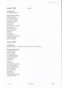
Document - MINING IN BENDIGO COLLECTION: LIST OF LEADING MINES
... Great Extended Hustlers... in Bendigo List of Leading Mines Annals Great Extended Hustlers ...BHS CollectionHandwritten list of leading mines and dividend paying mines from the Annals 1889, 1890, 1891 and 1909 includes companies over 2000 feet on 31st March 1891.document, gold, mining in bendigo, mining in bendigo, list of leading mines, annals, great extended hustlers, catherine united, garden gully united, hercules & energetic, johnsons reef, lazarus no 1, new chum consolidated, north johnsons, north argus united, rose of denmark, shamrock, st mungo, specimen hill united hustlers & redan, united devonshire, watson's kentish, johnsons reef no 1, dixon's tribute, fortuna hustlers, lady barkly, lazarus, new chum railway, new red white & blue, north old chum, confidence, golden age, hustlers reef, new hopeful, new argus, new chum united, virginia, carlisle, catherine reef united tribs, collman & tacchi, goldfields consolidated, hercules & energetic tribs, horwood & burrowes, koch's pioneer, koch's pioneer tribs, new chum goldfields, new red white & blue tribs, new prince of wales, new prince of wales tribs, new moon, n bendigo, suffolk united, suffolk united tribs, south new moon, the langdon, victoria propty, victoria consols, victoria consols tribs, windmill hill, windmill hill tribs, lansells 180, north old chum, victoria quartz, victory & pandora, new chum & victoria, old chum, ironbark, shenandoah, lansell's 222, garibaldi, eureka, great central -
 Bendigo Historical Society Inc.
Document - VICTORIA HILL - BENDIGO BRANCH HISTORICAL SOCIETY - MINE TOUR
... The Great Extended Hustlers... and Watsons' The Great Extended Hustlers A Richardson Typed notes ...Typed notes for a tour of the area. Areas mentioned are: Hospital Hill, The Central Deborah Mine, New Chum Railway Mine, The Rocks, New Chum Hill, Victoria Hill, Central Nell Gwynne, Rae's Open Cut, Housing Commission Homes and Latham and Watson's. Description of machinery at the Central Deborah Mine, yields, dividends, depth of shafts and directions to get ot the various places is included.document, gold, victoria hill, bendigo branch historical society mine tour, all saints church, joseph la trobe, bendigo's first hospital, sacred heart cathedral, the central deborah mine, city council, londonderry west shaft, new red, white and blue consolidated (big blue), a roberts & sons, big deborah, the new golden fleece, new chum goldfields, central wattle gully mine chewton, virginia consols, black's quarries coldstream, thompson's engineering and pipe co ltd castlemaine, new chum railway mine, golden square methodist church, the rocks, e j dunn, gold monument, shamrock mine, mt alvernia hospital, j b lazarus, john brown knitwear factory, gold fmines hotel, david sterry, new chum hill, fortuna villa, geo lansell, theodore ballerstedt, a h q survey regiment headquarters, old chum mine, central nell gwynne, rae's open cut, theodore ballerstedt, new chum syncline, little 180 mine, victoria quartz, wittcheibe's 'jeweller's shop', adventure, advance, cinderella, j n macartney, bendigo goldfields registry 1870, wm rae, johnson's devonshire mine, snobs hill mine, ellenborough mullock heap, belmont mullock heap, sadowa, st mungo, united devonshire, mechanic's institute, log lock-up, court house, j b watson, housing commission homes, hustlers hill, latham and watsons', the great extended hustlers, a richardson -
 Bendigo Historical Society Inc.
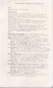
Document - Great Extended Hustler's and Tribute Companies, April, 2014
... Great Extended Hustlers...goldmining quartz mining Great Extended Hustlers Hustler's ...One page of data on the Hustler's No. 1 and Tribute Co. showing depth of shaft, quartz ore tons, gold produced, oz per ton, grams per ton, troy ounces and value in Australian dollars. goldmining, quartz, mining, great extended hustlers, hustler's tribute -
 Bendigo Historical Society Inc.
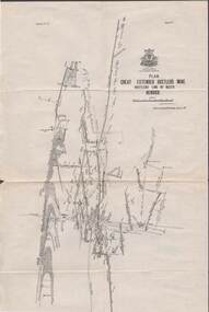
Map - STRUGNELL COLLECTION: HUSTLER'S LINE OF REEFS, BENDIGO, September 1913
... Map, Hustler's Line of Reefs, Great Extended Hustler's Mine... Bendigo great extended hustler's mine Underground Survey Office ...Map, Hustler's Line of Reefs, Great Extended Hustler's Mine Plan, Plate No. X1 (11). Bulletin No 33 Signed H.A.Whitelaw Underground survey Office Bendigo September 1913.Underground Survey Office, Bendigo.map, bendigo, great extended hustler's mine -
 Bendigo Historical Society Inc.
Document - MINING REPORTS - LIST OF GOLD MINES OR MINING COMPANIES
... Great Extended South Hustlers Co 1872... Extended Garden Gully Co 1874, Great Extended South Hustlers Co... Great Extended South Hustlers Co 1872 Great Republic Corp ...Handwritten list, (typed copy) by Albert Richardson, of Gold Mines or Mining Companies. Listed are: Australian United Quartz Co Sandhurst, Advance Co, Big Hill Tribute Co, Birds Reef Railway Reserve Mine Co, British Banner Gold M Co, Brookfield Gold M Co, Carlisle North Garden Gully, Caroline Gold M Co, Central Garden Gully, Charles Gavin Duff Gold M Co, Charleston Quartz, Cinderella Co, Collman Tacchi & Nelson, Confidnece Gold M Co, Cornish United Gold M Co, Derby Gold Mine Co, Dixon's Tribute Co, Ellesmere black Lead Tribute Co 1871, Empire Amalgamated, Extended Gold M Co (Majorca), Extended Co Victoria Reef, First Chance Tribute, Fortuna, Golden Fleece & Heales United, Garden Gully United, Garden Gully, Golden Fleece, Golden Point, Golden Lion Tribute Garden Gully Reef, Great Golden Fleece Co, Great Wonder Co, Gilmons Golden Palm Trib Co, Golden Garden Gully Co 1873, Golden Sovereign Extended Trib Co 1872, Great Extended Garden Gully Co 1874, Great Extended South Hustlers Co 1872, Great Republic Corp, Ironbark Co, Kangaroo Flat Steam Puddling & Qaurtz M Co, Riverpool Gold M Co, Iron Duke Co 1871, Henry Van Der Hugen Pioneer G M Co, Kent M Co, Kentish Co, Mariners Reef Co, Mary Hill Trib Co, Morning Star Gold Mine Co, Mount Korong Lane's Reef M Co, New Chum & Victoria Trib Co, New Hopeful Gold M C, New Homeward Bound, New Lord Warden Trib Co, North Lord Warden Trib Co, North Nelson, North Golden Pyke Co, North Old Chum, North Shamrock, North Birds Reef Co, North Birds Tribute Co, New Chum Freehold, New Era, No 3 Wilson's G M C, Odin Reef Co, Oriental Perserverance G M C, Paddy's Reef Trib Co, Palm Gold M Co, Palm Tribute Co, Pearl Tribute Co, Pegleg Gully Quartz G M C, Pegleg Quartz M C, Princess Dagmar G M C, Prince of Wales Amalgamated (Tarnagulla), Pyrances Gold M C, Passby United G M C, Quartz Hill Quartz M C, Pevieres Victory Trib Co, Royal Oak Quartz, Royal Standard Trib Co, Royal George Quartz G M C, Royal Golden Fleece, Sable Chief G M C, Sainia Reef Quartz M Co, South Fraser Reef G M C, Southern New Chum Gold M C, Shanandoor Tribute, Sebastian Gold M Co, Sophia & Redan G M Co, Youth Bell Vue Co, Shannon Company, South Extended Wallaby Co, South Ramrod Co, South Royal Hustlers Co, South Wallaby Trib Co, United Hustlers, United Hustlers & Redan Co, United Bros Tribute Co (Myrtle Creek), United Gold Mine Co, Victoria Reef Gold M Co, Victorian Consolidated M Co, Victoria Reef Quartz, Virginia Gold M Co, Victory and Pandora, Young Chum, South Homeward Bound Co, South Shilling Co, South Nuggetty Co, South Devonshire Co,South Keep it Dark, Try Again Tribute Co Victoria Hill.document, gold, mining reports, mining reports, list of gold mines or mining companies, australian united quartz co sandhurst, advance co, big hill tribute co, birds reef railway reserve mine co, british banner gold m co, brookfield gold m co, carlisle north garden gully, caroline gold m co, central garden gully, charles gavin duff gold m co, charleston quartz, cinderella co, collman tacchi & nelson, confidnece gold m co, cornish united gold m co, derby gold mine co, dixon's tribute co, ellesmere black lead tribute co1871, empire amated, extended gold m co (majorca), extended co victoria reef, first chance tribute, fortuna, golden fleece & heales united, garden gully united, garden gully, golden fleece, golden point, golden lion tribute garden gully reef, great golden fleece co, great wonder co, gilmons golden palm trib co, golden garden gully co 1873, golden sovereign extended trib co 1872, great extended garden gully co 1874, great extended garden gully co 1874, great extended south hustlers co 1872, great republic corp, ironbark co, kangaroo flat steam puddling & qaurtz m co, riverpool gold m co, iron duke co 1871, henry van der hugen pioneer g m co, kent m co, kentish co, mariners reef co, mary hill trib co, morning star gold mine co, mount korong lane's reef m co, new chum & victoria trib co, new hopeful gold m c, new homeward bound, new lord warden trib co, north lord warden trib co, north nelson, north golden pyke co, north old chum, north shamrock, north birds reef co, north birds tribute co, new chum freehold, new era, no 3 wilson's g m c, odin reef co, oriental perserverance g m c, paddy's reef trib co, palm gold m co, palm tribute co, pearl tribute co, pegleg gully quartz g m c, pegleg quartz m c, princess dagmar g m c, prince of wales amalgamated (tarnagulla), pyrances gold m c, passby united g m c, quartz hill quartz m c, pevieres victory trib co, royal oak quartz, royal standard trib co, royal george quartz g m c, royal golden fleece, sable chief g m c, sainia reef quartz m co, south fraser reef g m c, southern new chum gold m c, shanandoor tribute, sebastian gold m co, sophia & redan g m co, youth bell vue co, shannon company, south extended wallaby co, south ramrod co, south royal hustlers co, south wallaby trib co, united hustlers, united hustlers & redan co, united bros tribute co (myrtle creek), united gold mine co, victoria reef gold m co, victorian consolidated m co, victoria reef quartz, virginia gold m co, victory and pandora, young chum, south homeward bound co, south shilling co, south nuggetty co, south devonshire co, south keep it dark, try again tribute co victoria hill.