Showing 3051 items
matching highway
-
 Ballarat Heritage Services
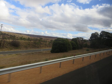
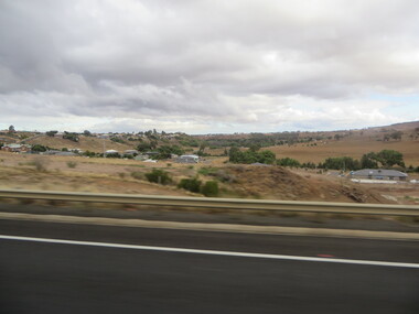
Photographs - Colour, Clare Gervasoni, Parkside Settlement near the Pentland Hills from the Western Highway, 2019, 31/03/2019
Colour photograph from the Western Highway. pentland hills, parkside -
 Ballarat Heritage Services
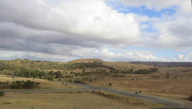
Photographs - Colour, Clare Gervasoni, Mt Buninyong from the Western Highway, 2019, 31/03/2019
Colour photograph from the Western Highway. mount buninyong -
 Ballarat Heritage Services
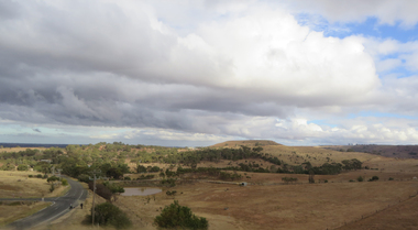
Photographs - Colour, Clare Gervasoni, Mt Buninyong from the Western Highway, 2019, 31/03/2019
Colour photograph from the Western Highway. mount buninyong -
 Charlton Golden Grains Museum Inc
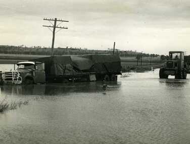
Photograph, Cameron, Ian, Road Transport run off road in flood water 1971, 12/11/1971
Road transport run off Calder Highway in 1971 flood water. Shire grader trying to remove truck. Used in Charlton Tribune Nov 12th, 1971.B/W photo of road transport run off Highway in flood water. Shire grader trying to remove truck.flood, calder highway, charlton -
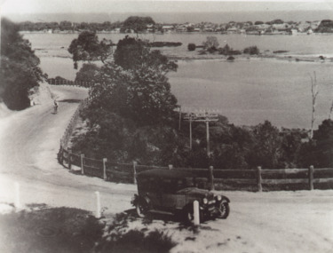 Lakes Entrance Historical Society
Photograph - Princes Highway around Jemmys Point, Lakes Entrance, H D Bulmer, 1930 c
Princes Highway around Jemmys Point, car parked on road at junction of original steep road to top of Jemmys Point. Man on bicycle riding up hill. Bullock Island and New Works in distance over North Arm and Cunninghame Arm waterways Lakes Entrance VictoriaBlack and white photograph of lower section of Princes Highway around Jemmys Point, car parked on road at junction of original steep road to top of Jemmys Point. Man on bicycle riding up hill. Bullock Island and New Works in distance over North Arm and Cunninghame Arm waterways Lakes Entrance Victoriaroads and streets, township, waterways, fences, vehicles -
 Whitehorse Historical Society Inc.
Article, Burwood Highway, 29/01/1992 12:00:00 AM
Burwood Highway is official.(official name change)Burwood Highway is official.(official name change)Burwood Highway is official.(official name change)burwood highway, roads and streets -
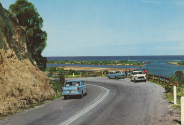 Lakes Entrance Historical Society
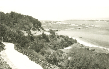
Postcard - Princes Highway Lakes Entrance, AFK International Publishers, 1970 c
Parking bay for viewing the Entrance situated on a sharp bend of the Princes Highway. Also in image part of Bullock Island and New Works area. Three motor cars in picture, post and rail safety fence Lakes Entrance Victoria. Also three colour postcards of same view showing progress at parking bay to steel mesh fence and steel guard rails numbers 04206.1, size 9 x 14 cm, 04206.2, 04206.3 size 10 x 14.5 cmColour postcard showing parking bay for viewing the Entrance situated on a sharp bend of the Princes Highway. Also in image part of Bullock Island and New Works area. Three motor cars in picture, post and rail safety fence Lakes Entrance Victoriacivil engineering, islands, waterways, gippsland lakes, vehicles -
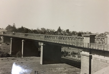 Kew Historical Society Inc
Photograph, Outer Circle Railway Viaduct, 1919
Railway Viaduct constructed for the Outer Circle Railway. Bridge designed by John Monash, engineer. Converted into a state highway, 1930s.Dateable photo of an important piece of Victorian railway infrastructure.Photograph of Outer Circle Railway Bridge over River Yarra, Fairfield. Looking toward Lugton Street, showing fence underneath taken from the Chandler Highway. Reverse: "Outer Circle Railway Bridge over River Yarra Fairfield, H0276, Property of Miss Foley"railway viaduct, chandler highway -
 Ballarat Heritage Services
Photographs - Colour, Clare Gervasoni, Bacchus Marsh from the Western Highway, 2019, 31/03/2019
Colour photograph of Bacchus Marsh from the Western Highway. bacchus marsh -
Ringwood and District Historical Society
Photographs, 12 coloured photographs of Maroondah Highway and around clock tower. c1990s, C1990s
12 coloured photographs of Maroondah Highway and around clock tower -
 Ringwood and District Historical Society
Photograph, Maroondah Highway Central, Ringwood. Site of old Town Hall, cnr. Maroondah Highway and Melbourne St, Ringwood - 1971
Black and white photograph (2 copies- 1 large, 1 small)Written on rear backing sheet: "Site of old town hall. Cnr. Maroondah Highway and Melbourne St." -
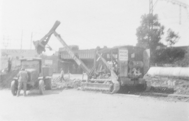 Ringwood and District Historical Society
Photograph, Maroondah Highway Central, Ringwood. Roadworks on Maroondah Highway, c1930
Black and white photograph (2 copies- 1 large, 1 small) of roadworks. Typed below large photograph: "Roadworks on Maroondah Highway circa 1930 Warrandyte Rd. subway behind". -
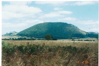 Buninyong & District Historical Society
Photograph - Original Photograph, Ann Beggs-Sunter, Mount Buninyong from Midland Highway at Scotsburn, 1996, November 1995
historic transportColour photo, Mount Buninyong from Midland Highway at Scotsburn, 1996mount buninyong -
 Ballarat Heritage Services
Photographs - Colour, Clare Gervasoni, Underbank Development at Bacchus Marsh from the Western Highway, 2019, 31/03/2019
Colour photograph of the Bacchus Marsh suburb of Underbank from the Western Highway. bacchus marsh -
 Ballarat Heritage Services
Photographs - Colour, Clare Gervasoni, Bacchus Marsh from the Western Highway, 2019, 31/03/2019
Colour photograph of the Bacchus Marsh suburb of Underbank from the Western Highway. bacchus marsh -
Lakes Entrance Historical Society
Book, Boyes, Rosemary B.E.M, The Hume Highway Today and Yesterday, 1978
Stories and photographs illustrating a little of the Hume Highway between Melbourne and AlburyCopy of inscription in Sutherland family history file.roads and streets -
 Lakes Entrance Historical Society
Postcard - Lakes Entrance viewed from Jemmys Point, Rose Series, 1925 c
Post and rail fence beside highway and no vegetation on sand dunes eastern part of Cunninghame ArmBlack and white postcard showing view of Cunninghame Arm from Jemmys Point, gravel Princes Highway, North Arm bridge and end of town Lakes Entrance VictoriaNearing Lakes Entrance on the Princes Highwaytownship, waterways -
Whitehorse Historical Society Inc.
Newspaper, Along the highway, 1992
A guide to business along the Maroondah Highway from Middleborough Road to Heatherdale Road.A guide to business along the Maroondah Highway from Middleborough Road to Heatherdale Road.A guide to business along the Maroondah Highway from Middleborough Road to Heatherdale Road.maroondah highway blackburn, pharmacies, maroondah highway mitcham, athan, savvas, maroondah highway nunawading, gelb, joe, mitcham shopping centre, regal kitchens, blackburn, nunawading fire station, armstrong, norman -
Whitehorse Historical Society Inc.
Article, The Maroondah Highway - past, present and future, 1/10/1970 12:00:00 AM
Supplement to C.R.B. News, 1970 giving detailed history and description of the Maroondah Highway.Supplement to C.R.B. News, 1970 giving detailed history and description of the Maroondah Highway.Supplement to C.R.B. News, 1970 giving detailed history and description of the Maroondah Highway.maroondah highway, whitehorse road, victoria. country roads board -
 Brimbank City Council
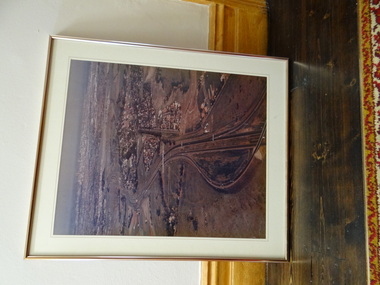
Framed Colour Photograph, View of the city and highway from western suburbs 1985
Framed Colour Photograph - View of the city and highway from western suburbs 1985 -
Lakes Entrance Historical Society
Book, Gardner, P D, Names on the Omeo Highway, 1991
Names on the Omeo Highway, Victoria, between Bairnsdale and Omeo; their origins, meanings and historysocial history, historic sites, land settlement -
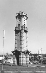
 Ringwood and District Historical Society
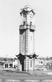
Photograph, Maroondah Highway West, Ringwood- 1974. Clocktower on new site
Black and white photographClocktower on corner of Maroondah Highway and Wantirna Road. -
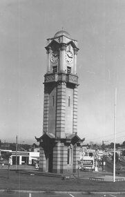
 Ringwood and District Historical Society
Photograph, Maroondah Highway West, Ringwood- 1974. Clocktower on new site
Black and white photographClocktower on corner of Maroondah Highway and Wantirna Road. -
 Ringwood and District Historical Society
Photograph, Maroondah Highway West, Ringwood- 1974. Clocktower on new site
Black and white photographClocktower on corner of Maroondah Highway and Wantirna Road. -
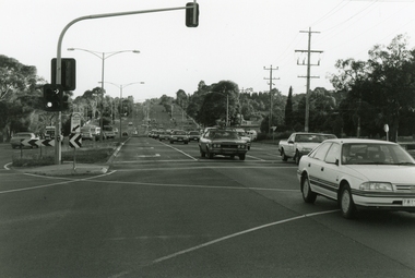 Ringwood and District Historical Society
Photograph, Maroondah Highway, Ringwood, looking east from Oban Road - 1999
Looking East along Maroondah Highway, near the corner of Oban Road in December 1999 -
Whitehorse Historical Society Inc.
Map, Burwood Highway, c1970
Enlarged aerial photo of area South of Burwood Highway to Dandenong Creek, Vermont South.Enlarged aerial photo of area South of Burwood Highway to Dandenong Creek, Vermont South.Enlarged aerial photo of area South of Burwood Highway to Dandenong Creek, Vermont South.dandenong creek, morack road, vermont south, burwood highway, vermont south, aerial photographs -
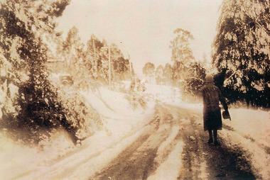 Mt Dandenong & District Historical Society Inc.
Photograph, Miss Perriman on Main Highway, Kalorama 1931, c1930
Back view of Miss Perriman walking along the Main Highway, Kalorama, in the snow in 1931.kalorama, snow, main highway, perriman -
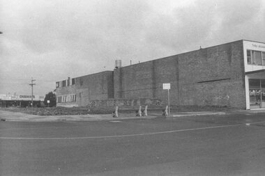
 Ringwood and District Historical Society
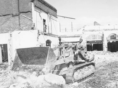
Photograph, Maroondah Highway Central, Ringwood. Demolishing Coffee Palace and shops, corner of Maroondah Highway and Adelaide Street, 1966
Black and white photographWritten on back of photograph: "Demolishing Coffee Palace and shops on corner of Maroondah Highway and Adelaide St (west corner) Ringwood. 1966." -
 Charlton Golden Grains Museum Inc
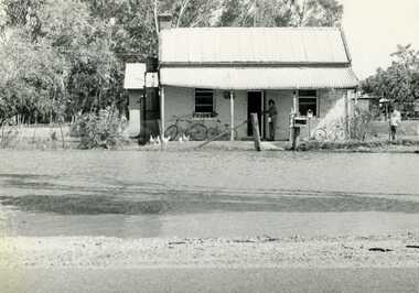
Photograph, Charlton Tribune, 1973 February Flood, Feb 1973
Feb 1973 flood Charlton, Victoria. Old Ive's house with floodwater to front fence on the Calder Highway opposite Charlton Park Gates. Mrs Gloria Jordan.B/W Photograph of February 1973 flood. Old Ive's house with floodwater to front fence on Calder Highway opposite Charlton Park gates. Photo used in Charlton Tribune on 09/07/1973 P4.flood, charlton, calder highway, local brick -
 Lorne Historical Society
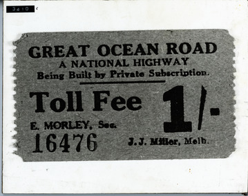
Photograph, G.O.R National Highway Private Subscription Toll fee ticket
Photograph National Highway private subscription toll fee for the G.O.R. Cost 1/- (one shilling)toll-fee: toll-ticket; g.o.r