Showing 2918 items matching "highways"
-
 Lakes Entrance Historical Society
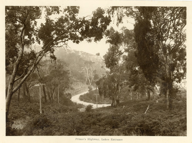
Postcard - Princes Highway Kalimna, 1920c
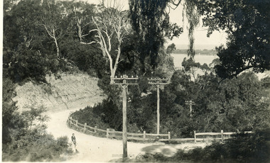
Sepia toned large format postcard of a bend in the Princes Highway at Kalimna. It shows a bracken covered hill in foreground, some larger trees, steep roadside cutting and post and rail fence at the edge of the road. Picture shows fog rising through trees. Lakes Entrance VictoriaPrinces Highway Lakes Entrance roads and streets, topography -
 Lakes Entrance Historical Society
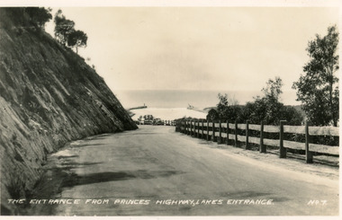
Postcard - Princes Highway Lakes Entrance, Valentine Series, 1940c
Black and white small format postcard of the Princes Highway at Kalimna Hill The road winds between the steep road cutting and a post & rail guard fence. In the distance is the artificial entrance to the Gippsland Lakes. Lakes Entrance VictoriaThe entrance from Princes Highway, Lakes Entranceroads and streets, fences -
 Ringwood and District Historical Society
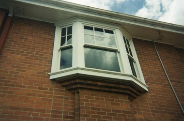
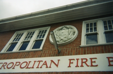
Photograph, Ringwood Fire Station at 255 Maroondah Highway circa 1998, Feb-98
This fire station was closed and a new one opened on Maroondah Highway on the site of the old miner's cottage near the corner of the Highway and Mt Dandenong Road.Five coloured photographs of the Ringwood fire station at 255 Maroondah Highway and of the fireman's house when it was sold. It later became 'The Fire Station Restaurant.' -
 Ringwood and District Historical Society
Photographs, Ringwood Fire Station at 255 Maroondah Highway circa 1998
This fire station was closed and a new one opened on Maroondah Highway on the site of the old miner's cottage near the corner of the Highway and Mt Dandenong Road.Five coloured photographs of the Ringwood fire station at 255 Maroondah Highway and of the fireman's house when it was sold. It later became 'The Fire Station Restaurant.' -
 Whitehorse Historical Society Inc.
Map, City of Nunawading Street and Block Map
City of Nunawading Street and Block map.City of Nunawading Street and Block map. Scale: 1:10,000. with enlargement, Canterbury Road South to Burwood Highway.City of Nunawading Street and Block map. canterbury road nunawading, burwood highway burwood east, city of nunawading -
 Lakes Entrance Historical Society
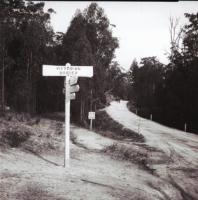
Photograph - Victoria/N.S.W. Border, 1950 c
Another black and white photographs of tree ferns and scenery along the Princes Highway 05316. 1 Black and white photograph of Princes Highway as gravel road at Victoria N.S.W. border looking south to Victoriaroads and streets, borders, vegetation -
 City of Kingston
Photograph - Black and white
This photograph depicts the road diversion on Nepean Highway that was implemented to allow construction of the railway line underneath the Nepean Highway at Moorabbin. An "Allourie" Cheese, Honey Canned Ham van is prominent on the left of the image, the railway gates are central and the old Moorabbin Station is visble. Beyond the dates, pedestrians are visible crossing the Nepean Highway. This image is part of a larger collection of images from the Public Transport Corporation displaying train stations and streetscapes in what is now the City of Kingston.In 1958 excavations began for the removal of the level crossing gates at the southern end of the Moorabbin shopping centre on Nepean Highway. The station was also lowered below ground. A diversion route was created to enable the flow of traffic in both directions along the highway.Black and white photograph of road diversion on Nepean Highway, Moorabbin to allow the construction of the railway line below the Nepean Highway at Moorabbin and also to trench the station. This image is part of a larger collection of images from the Public Transport Corporation displaying train stations and streetscapes in what is now the City of Kingston.White adhesive dot sticker: Printed black 199 Handwritten in red ink: 80% Handwritten in black ink on yellow Post-It Note: [indecipherable] 199 - Diversion for Crossing Stamped in blue ink: COPYRIGHT Public Transport Corporation, For reordering photographs, Please quote negative No m 5687, Enquiries C/- PTC Photographic Unit, Telephone switchboard 619 1111railway crossing, railway station, city of moorabbin -
 Lakes Entrance Historical Society
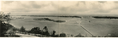
Postcard - Bullock Island, Bulmer H D No 15, 1930 c
Black and white double size postcard of Bullock Island. It shows a glimpse of the Princes Highway in foreground, wooden foot bridge to Bullock Island, houses on the hummocks, entrance and Bass Strait in background, boat entering lakes. Lakes Entrance VictoriaPanorama of Lakes Entrance from Princes Highwaywaterways, islands, township, civil engineering -
 Lakes Entrance Historical Society
Postcard, Bulmer H D, 1940c
Black and white postcard of a bend in the Prince's Highway as it winds around Jemmys Point. Steep road cutting on upper side of gravel road, post and rail fence on lower side, schoolboy sitting on fence in foreground, dense vegetation on top of cutting and gully beneath road. Lakes Entrance VictoriaA bend in the Princes Highway, Lakes Entrancefences, transport, roads and streets, islands -
 City of Kingston
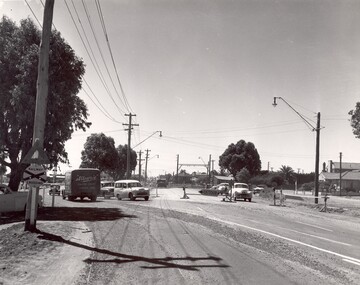
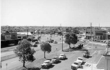
Photograph - Digital image, Black and white, Roads - Junction of Nepean Highway and South Road, c. 1950
Junction of Nepean Highway and South Road, Moorabbin - Moorabbin Hotel on right. Shops in centre demolished for road widening in 1980'sBlack and white image of Nepean Highway and South Road junction point of view from Kingston Town HallPrinted in black text a round white sticker: 234 Handwritten in red ink 80% Yellow post it note written in blue ink: CHAP 7 234 / - Nepean Hwy + South Roadnepean highway, south road, moorabbin, moorabbin hotel -
 City of Kingston
Photograph - Black and white, c. 1950
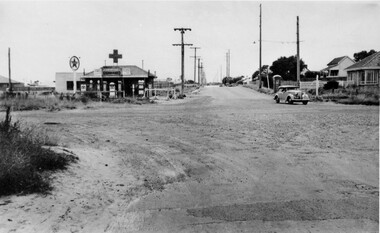
The intersection of Warrigal Road and Nepean Highway is now a major intersection, serviced by traffic lights. In the 1950s it was a joining of two sealed roads, although covered in gravel, and with wide gravel shoulders. There are no traffic signs and the few houses visible are not set very far back from the road. This image is one of many in the collections that focuses on either roads or the railway. The development of roads and the railway was crucial to the ongoing development of the area.Black and white photograph of the intersection of Warrigal Road and Nepean Highway, Mentone. Handwritten in blue ink on reverse: 218 Handwritten in red ink on reverse: 75%mentone, roads, suburbs -
 Lakes Entrance Historical Society
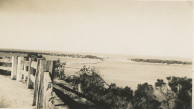
Photograph - The Entrance Lakes Entrance, 1925 c
The entrance to Gippsland Lakes taken from Princes Highway, post and rail fence in foreground Lakes Entrance VictoriaBlack and white photograph of entrance taken from Princes Highway, post and rail fence in foreground Lakes Entrance Victoriaboats and boating, islands, waterways, gippsland lakes -
 Ringwood and District Historical Society
Photograph, Maroondah Highway Central, Ringwood. Ringwood Town Hall c1930s
2 copies of Black and White Photograph (one large, one small) of Ringwood Town Hall, with bushes in front in centre strip of Maroondah Highway. Similar to VC#796 but possibly later. Image of Ringwood Town Hall, with bushes in front in centre strip of Maroondah Highway. -
 Stawell Historical Society Inc
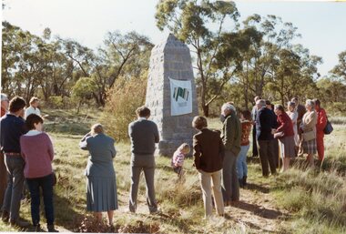
Photograph, Major Mitchell restored plaque unveiling on the Western Highway
Unveiling of restored Major Mitchell plaque on Western HighwayActing Mayor of Stawell: Frank Jeffrey unvieling of the Major Mitchell plaque on the western highway near Stawell 150 years after Major Mitchell had passed this spot.stawell -
 Lakes Entrance Historical Society
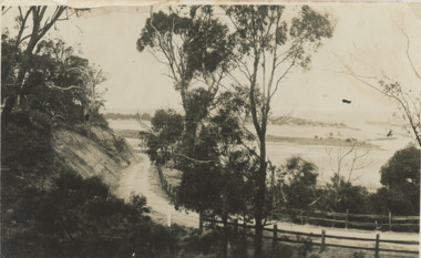
Postcard - Princes Highway around Jemmy's Point
Princes Highway around Jemmy's Point . Unsealed road and post and rail fence. Bullock Island and the entrance in the distance c1925Black and white photograph of Princes Highway around Jemmy's Point . Unsealed road and post and rail fence. Bullock Island and the entrance in the distance waterways, topography, islands, roads and streets -
 Charlton Golden Grains Museum Inc
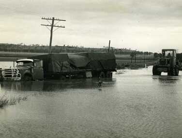
Photograph, Cameron, Ian, Road Transport run off road in flood water 1971, 12/11/1971
Road transport run off Calder Highway in 1971 flood water. Shire grader trying to remove truck. Used in Charlton Tribune Nov 12th, 1971.B/W photo of road transport run off Highway in flood water. Shire grader trying to remove truck.flood, calder highway, charlton -
 Stawell Historical Society Inc
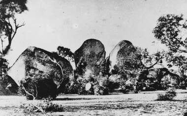
Photograph, Sister Rocks looking North c1860's
Sister Rocks. Looking North c1860's. This photo is of a well known land mark along the Western Highway. They take their name from 3 sisters named Levy, who camped there with their parents during the early days of Stawell. In 2011 photos were taken to update and add to our "Sister Rock" collection. Direction of photos has been identified and are catalogued as on the updated index card. Black & White print of a photograph depicting large granite boulders with trees in foreground. c1900Looking North from Western Highwaystawell scenery -
 City of Kingston
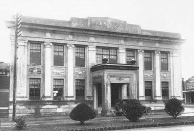
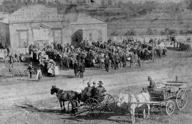
Photograph - Digital image, Black and white, Assembly at Mechanics Hall Temperance Hall and Free Library Cheltenham, c.1900
Gathering of people outside the Mechanics Hall, Temperance Hall and Free Library, Nepean Highway, Cheltenham - in background the railway line and paddocksBlack and white image of people gathering outside the Mechanics Hall, Temperance Hall and Free Library, Nepean Highway, Cheltenham - in background the railway line and paddocksRound red sticker: X16 [crossed out] Handwritten in blue ink circled: A5 Handwritten in red ink: 89%temperance hall, nepean highway, cheltenham, library, mechanics hall -
 Kew Historical Society Inc
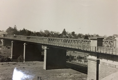
Photograph, Outer Circle Railway Viaduct, 1919
Railway Viaduct constructed for the Outer Circle Railway. Bridge designed by John Monash, engineer. Converted into a state highway, 1930s.Dateable photo of an important piece of Victorian railway infrastructure.Photograph of Outer Circle Railway Bridge over River Yarra, Fairfield. Looking toward Lugton Street, showing fence underneath taken from the Chandler Highway. Reverse: "Outer Circle Railway Bridge over River Yarra Fairfield, H0276, Property of Miss Foley"railway viaduct, chandler highway -
 Ringwood and District Historical Society
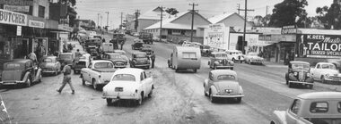
Photograph, Maroondah Highway West, Ringwood, 1955. Saturday morning shopping in Maroondah Highway
Black and white photograph of shopping area along Maroondah Highway. Coolstores in background. (2 copies)Typed below photograph: "Saturday morning shopping in Maroondah Highway looking towards corner of Wantirna Rd. with old coolstores in background. 1955. Written on back of loose photograph, "Wantirna Rd. between Ibbotson's and coolstore. -
 City of Kingston
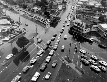
Photograph - Black and white, c. 1950
The image shows a line of traffic travelling along South Road in response to traffic light signlas while an increasing number of cars are banking up along Nepean Highway, also in response to traffic light signals.This image provides a strong contrast to images from earlier eras of the same intersection. The amount of traffic has increased enormously as well as commercial development.Black and white photograph with an aerial view of the intersection of Nepean Highway and South Road, taken from above the Moorabbin Council Chambers.Handwritten in black ink Pic [indecipherable] / 1000 Handwritten in red ink: 150%moorabbin, traffic lights, cars, nepean highway -
 Lakes Entrance Historical Society
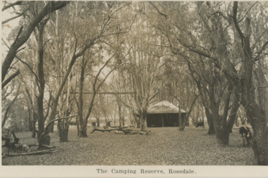
Postcard, Camping Reserve Rosedale, 1940 c
Also a black and white postcard of highway bridge over the Latrobe River Rosedale 05412.1 9 x 14 cmBlack and white postcard of camping reserve showing picnic shelter and two fire places set in timbered area and glimpses of highway bridge through trees Rosedale VictoriaThe Camping Reserve Rosedalecamping, bridges -
Clunes Museum
Album - CATALOGUE, 1999
CATALOGUE PROGRAMME OF COURT HOUSE PAINTINGS AT EXHIBITION IN THE HIGHWAY GALLERY 14 HIGHWAY MOUNT WAVERLY 6-30 JUNE 1999..1 A SMALL WHITE BOOKLET FROM THE HIGHWAY GALLERY OF OUR GOLDEN HERITAGE. PRIVATE COLLECTION OF COURT HOUSES OF VICTORIAN GOLDFIELDS TOWNS. .2 INVITATION - PRINTED ON GREEN CARD TO EXHIBITION AT MT. WAVERLY 30 - 6 - 1999. .3 LECTURE PROGRAMME FOR OUR GOLDEN HERITAGElocal history, document, catalogue, paintings, paintings of courthouses -
 Lakes Entrance Historical Society
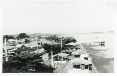
Photograph - Esplanade Lakes Entrance, Rodman, George, 1950c
The carnival was held annually during the Christmas holiday period, during the middle of the century, it was moved later to a vacant block over the highwayBlack and white photograph of Esplanade, showing the stalls and carousel of the town carnival, set up between the cypress trees on Esplanade, houses on other side of highway in the background. Lakes Entrance Victoriawaterfront, entertainment, township, memorials -
 Lakes Entrance Historical Society
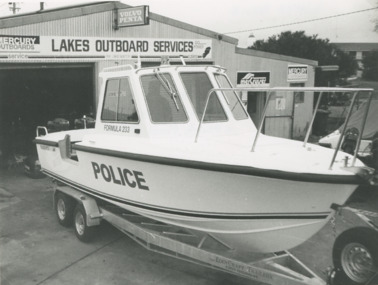
Photograph - Water Police boat for WA, Lakes Post Newspaper, 1/06/1996 12:00:00 AM
new Water Police boat for WA on trailer outside Lakes Outboard Services Princes Highway Lakes Entrance Victoria. Hull was built at Bairnsdale. Lakes Entrance Outboard Specialists David Newton and Mark Frost fitted motors.Black and white photograph of new Water Police boat for WA on trailer outside Lakes Outboard Services Princes Highway Lakes Entrance Victoriapolice, boats and boating, boat building -
 Ringwood and District Historical Society
Photograph, Composite Aerial Views of Ringwood, Victoria - 1972
Two composite black & white aerial photographs with north-facing view over Maroondah Highway, including Railway Station precinct, Civic Centre precinct, Eastland, Mount Dandenong Road, Bedford Road, Ringwood Street, Warrandyte Road, Mullum Road, Loughnan's Road.Department of Crown Lands and Survey. Maroondah Highway Project - Run 3 - 20.1.72 - 3,900' ASL. -
Ringwood and District Historical Society
Photograph, Last naturally occurring gum tree - Maroondah Hwy Ringwood, 1959, 1959
There was widespread objection to the removal of this gum tree which was obstructing the Maroondah Highway at this location.Photograph of the last naturally occurring gum tree on Maroondah Highway 1959 - yellow box, 60ft high, 75 years old, standing next to Bill Patterson Motors building west of New Street. +Additional Keywords: Bill Patterson Motors -
 City of Kingston
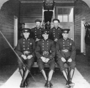
Negative - Colour, 1926
Until 1911 Cheltenham had a local Voluntary Fire Brigade. In that year the Metropolitan Fire Brigade was formed and through it a hall was built on the Highway at a cost of £350. Eight years later a brick house costing £1151 was added. There were two full time firemen; several others served part time. In 1960 the fire protection system was re-organised; the building on the Highway was demolished and replaced by the Ambulance Station.Two images on one strip of negative film. The first image is a black and white image of five firefighters pictured inside Cheltenham Fire Station, Nepean Highway. The second image is of the firefighting truck at the station. -
 Lakes Entrance Historical Society
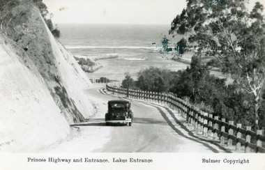
Postcard - The Entrance, Bulmer H D, 1930c
Black and copy 9 x 13.5, has inscription 'Princes Highway and Entrance, Lakes Entrance', ink spill on photo top right hand areaTinted small format postcard of the Princes Highway winding around Jemmys Point, between the steep road cutting and post and rail fence, entrance to Gippsland Lakes in the distance. Lakes Entrance Victoria waterways, roads and streets, vehicles -
 Kew Historical Society Inc
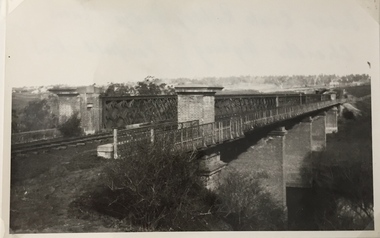
Photograph, Railway Viaduct, c.1919
The railway viaduct linking Kew and Fairfield was created for the Outer Circle railway.Railway viaduct, Yarra River, linking Kew and Fairfield. Built by John Monash for the Outer Circle Railway. In 1930 converted into the Chandler Highway Bridge for vehicular traffic. The point-of-view of the photograph shows Kew in the distance. Annotations on reverse: "Outer Circle Railway Bridge (now Chandler Highway) Fairfield-Kew, about 1919. Property of Miss Foley.outer circle railway, railway viaduct (kew), john monash