Showing 41 items matching "home gardening"
-
 City of Kingston
Photograph - Black and white, 20 December 1945
This aerial photograph depicts the changing landscape of Cheltenham and Highett since WWII. Photographed in 1945, there is a mix of urban dwellings and industrial development and precedes the major transformation of Cheltenham with the development of the Southland shopping centre in the 1960s and expansion in the 1990s.A large part of Cheltenham was originally established as a rural market gardening community. The railway line and station brought urban development to the area and in the north, the Highett area was dominated by the Highett Gas Works. Cheltenham became a major destination for shopping in the 1960s with the opening of Southland.Aerial photograph taken in 1945 of Cheltenham and Highett within the City of Kingston. The image includes the Highett Reserve, (top right), the Methodist Children Homes (now Southland), Nepean Highway and Jamieson Street. Highett Gas Works is visible in the top left and the land now named William Fry Reserve at the intersection of Bay Road and Nepean Highway. A visible large parcel of land on the corner of Bay Road and Nepean Highway was developed in the 1990s as the west side addition to Southland. The densely vegetated area in the upper right sector of the image is now dense with housing. Tulip Grove, Heather Grove and Gilford Street are visible bottom left. This image is possibly from the collection of aerial photographs commissioned by the Department of Crown Lands and Survey and taken by Adastra Airways.Black ink: 57252 White lettering: VIC-10 57252 20.12.45 [lens information indecipherable] PROJ. No.5 MELB. METROP AREA Black pencil: 80highett, cheltenham, highett gas works, urbanisation -
 City of Kingston
Photograph - Black and white, 20 December 1945
This aerial photograph depicts the changing landscape of Cheltenham and Highett since WWII. Photographed in 1945, there is a mix of urban dwellings and industrial development and precedes the major transformation of Cheltenham with the development of the Southland shopping centre in the 1960s and expansion in the 1990s.A large part of Cheltenham was originally established as a rural market gardening community. The railway line and station brought urban development to the area and in the north, the Highett area was dominated by the Highett Gas Works. Cheltenham became a major destination for shopping in the 1960s with the opening of Southland.Aerial photograph taken in 1945 of Cheltenham and Highett within the City of Kingston. The image includes the Highett Reserve, (top right), the Methodist Children Homes (now Southland), Nepean Highway and Jamieson Street. Highett Gas Works is visible in the top left and the land now named William Fry Reserve at the intersection of Bay Road and Nepean Highway. A visible large parcel of land on the corner of Bay Road and Nepean Highway was developed in the 1990s as the west side addition to Southland. The densely vegetated area in the upper right sector of the image is now dense with housing. Tulip Grove, Heather Grove and Gilford Street are visible bottom left. This image is possibly from the collection of aerial photographs commissioned by the Department of Crown Lands and Survey and taken by Adastra Airways.Black type: Reverse lettering VIC-10 57252 20.12.45 [lens information indecipherable] PROJ. No.5 MELB. METROP AREA White lettering: Reverse writing 57252cheltenham, highett, highett gas works, urbanisation -
 City of Kingston
Photograph - Black and white, 3 March 1954
Cheltenham and Moorabbin are suburbs within the City of Kingston that were originally established as rural market gardening communities The area is bordered by Highett and Mentone. The market gardens, farms and paddocks have gradually been sub-divided into housing and industrial estates. Highett is developed with residential homes but was also the site of major facilities such as the Highett Gas Works. This aerial image covers a diverse section of the City of Kingston, taking in the suburbs of Moorabbin, Cheltenham, Highett and Mentone Residential housing development is prominent along the Frankston Railway line and the area still retains extensive market gardens and paddocks yet to be converted to a large industrial and commercial zone.Aerial photograph of Mentone, Cheltenham and Moorabbin within the City of Kingston. The area depicted in this 1954 aerial view includes Warrigal Road and Centre Dandenong Road intersection (top left); Charman Road, Patty Street, Bourke Street, Collins Street Mentone (top right); Keys Road Moorabbin (bottom left); Bay Road, Cheltenham (bottom right), Friendship Square, Cheltenham Park, Victoria Golf Club and Jack Barker Oval are visible. Nepean Highway and the Frankston railway line run centrally through the image. Highett Gasworks is also evident.White handwriting and type [indecipherable]. White image of clockface White image of compass White type 42956 Black handwriting 3/3/54 Williams [indecipherable] Black pencil: S [arrow] Black ink: 3/3/1954cheltenham, moorabbin, mentone, highett, market gardens -
City of Kingston
Photograph - Black and white, 27 February 1964
Cheltenham is a suburb in the City of Kingston that was originally established as a rural market gardening community. The area is bordered by Highett. The previous market gardens, farms and paddocks have gradually been sub-divided into housing and industrial estates. The Methodist Children's Home Methodist Homes for Children and St John of God Training Centre on the site of the future Southland shopping centre has not yet been demolished. The recently built Cheltenham High School is visible and the increased urbansation of the area is evident. Some farmland remains including the Le Page homestead.The developing urban area of Cheltenham within the City of Kingston. This image illustrates the mid-century urban sprawl of of Cheltenham and the subdivision of market gardens within the municipality and the changing demographic of the district as new houses are constructed and infrastructure established.Aerial photograph of the suburbs of Cheltenham and Highett within the City of Kingston. Highett Gas Works (top left); Bernard Street, Cheltenham (top right); Weatherall Road (bottom left): Elliott and Cobham Streets Cheltenham (bottom right).White handwritten: X Vic.1831 White type: MELBOURNE 1963 PROJECT RUN23 [underlined] 27-2-64 LENS 205 152-70 M/M 5.150 [arrow] White handwritten: X 166 cheltenham, highett, urbanisation -
 City of Kingston
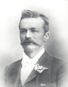
Photograph - Black and white, Francis Thomas Le Page
Photographic portrait of Francis (Frank) Thomas Le Page. Frank is the oldest child of Nicholas and Rachel (nee Addy), who arrived in Melbourne in 1852 from Guernsey in the Channel Islands. Nicholas was a tailor and Rachel was a dressmaker. They originally made their home in Prahran and set up a business but about two years later decided to take up market gardening. The Le Page family bought property in the Two Acre Village, Cheltenham. They had nine other children. At 14 years of age Frank was driving his father’s horse and dray to Melbourne with the vegetables they grew - standing backed in to the footpath in Little Collins Street, at the old Eastern Market. At 18 years of age, and the other members of the family growing up, Francis decided to seek work outside, and was employed as a gardener by Mr Budd, who conducted the Brighton Grammar School. It was whilst employed there that the late Sir Thomas Bent and he became friends, a friendship which lasted throughout their lives. Sir Thomas was then on the land also. Frank was an active member of social and sporting groups in the region. In 1876 Frank married Mary Geraghty and they made Cheltenham their home. He became a councillor for the then Shire of Moorabbin, a position he held for 25 years, and in 1902 was elected President of the Shire of Moorabbin. He was also a Justice of the Peace and occupied the bench at the Cheltenham Court. The next generation of Le Pages continued to be heavily involved in the civic life of the region with Frank and Mary's son Everest being elected mayor twice.Black and white image of Francis (Frank) Thomas Le Page. -
University of Melbourne, Burnley Campus Archives
Newspaper - Newspaper Cutting, The Age, Tessa Smith, 1896-1933
... (1) "Landscape Gardening - Hints for Adelaide Home Lovers... design home garden design (1) "Landscape Gardening - Hints ...(1) "Landscape Gardening - Hints for Adelaide Home Lovers," copy of article in "The News" (Adelaide) 21 August, 1923 p6 by Tessa Smith (former student). (2) "News of the Day" copy of article in "The Age" 8 October, 1896 p4. T. Smith in a play. (3) "Opportunities in Adelaide" copy of article in "The News" (Adelaide) 17 September, 1923 p6 by Tessa Smith on garden design. (4) "Social Notes" copy of article in "The Advertiser" 1 February, 1932.landscape gardening, tessa smith, female students, garden design, home garden design -
 Bendigo Historical Society Inc.
Slide - DIGGERS & MINING. LIFE OF THE SELECTORS, c1882
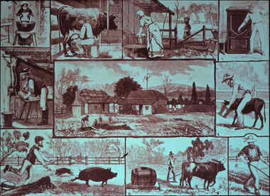
BHS CollectionDiggers & mining. Life Of The Selectors. Show some of the every day activities of a Selectors family; washing dishes, milking the cow, washing clothes, storage, shearing, chasing the pigs, carting water, ploughing, feeding the calf, gardening. Markings: Life Of The Selectors. Set 432 No. 7. The Free Selector at Home ''Illustrated Australian News,'' June 10, 1882. Used as a teaching aid.Visual Education Centreeducation, tertiary, goldfields -
City of Moorabbin Historical Society (Operating the Box Cottage Museum)
Newsletter - CMHS Moorabbin Mirror Vol 6 April 2016, Moorabbin Mirror Vol 6 April 2016, April 2016
This is Vol. 6 of the Moorabbin Mirror produced by CMHS members Fran & Holger Bader , Valma Sharp April 2016 The Moorabbin Mirror reflects the history and heritage of the former City of Moorabbin — derived from Mooroobin, ‘a resting place’ in the Bunurrung spoken language. In 1994, the City of Moorabbin was integrated into the Cities of Bayside, Glen Eira, Kingston and Monash. This issue of the Moorabbin Mirror is dedicated to all the young, and not so young, men and women from the former City of Moorabbin who served ‘King and Country’ during the Great War. Especially those who never came home including a photo of WW1 Mordialloc Memorial and the 2016 Local Commemorative Services. Valma Sharp CMHS President 'officially opened' the new WC and thanked GECC for this amenity. Members and Guests then shared light refreshments before welcoming visitors to the BCM Extra Open Day. Unfortunately Lorna Thatcher was unable to attend due to a sudden illness and Committee and members sent Get Well wishes via Frank. The Diary informs members of the Extra Open Days, upcoming publicity events , Meetings and Community Group visits to BCM, Local interest items include Lees Nursery, Market Gardening Heritage, Westall UFO, Joyce Park Playground Solar System., Moorabbin Ten Pin Bowl and the School Amateur Radio Special Event. The Committee is very grateful for the help provided by David Hardham GEHS to set up our new CMHS website. An informative article re the 2012 GESAC that replaced the 1964 Olympic Pool. Information is requested for the Roving Curator August Rietman display 2017.This is Vol. 6 of the Moorabbin Mirror, Newsletter of CMHS April 2016A4 x 3 paper folded to A5 x 6pp with colour photographs. Moorabbin / Mirror / April 2016 Vol 6moorabbin mirror, bader fran, bader holger, sharp valma, hardham david, thatcher lorna, anzac memorial mordialloc, anzac, lees nursery thomas st brighton east, gesac, moorabbin ten pin bowling, joyce park playground ormond, bentleigh, moorabbin, mckinnon, roving curator program mav, westall ufo, -
 Kiewa Valley Historical Society
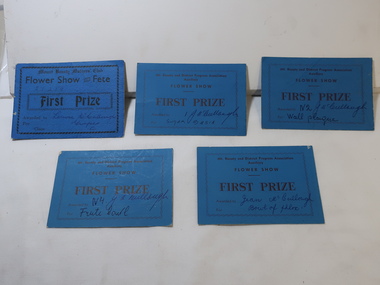
Cards - Gardening First Prize
Mt Beauty township was created in the late 1940s when the SECV built houses, roads, amenities etc. for their workers working on the Kiewa Hydro Electric Scheme. The town was built on a paddock so gardening was popular amongst the population.The residents of Mt Beauty created gardens for their new homes and were encouraged to enter competitions for the best flowers etc.. This was an enjoyable social occasion for them. 5 blue cardboard cards won for First Prize in 'Flower Show and Fete' presented by the Mt Beauty and District Progress Association Auxilary and the Mt Beauty Mothers Club.Name of winner written on each - won by members of the McCullough familygardening, flower show, mccullough family, mt beauty progress association -
 Whitehorse Historical Society Inc.
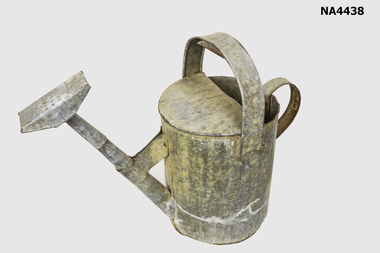
Functional object - Watering Can, 1920s
The watering can was handmade by the donor's grandfather Arthur Edwards when they moved into their new home in Forest Hill.Watering Can. Galvanised. Three Gallon with attached oblong spray. Top handle with mould for easy watering; all joints soldered.commerce, containers, domestic, domestic items, gardening, metalcraft, steel work, trades, tinsmithing -
 Lakes Entrance Historical Society
Photograph - Garden club, Lakes Post Newspaper, 2000
number in album 03554.02Colour photograph Lakes Organic Gardening Society members Adele Greenbeau, Bob Hodgson, at Carol McDonalds home with platter of organically grown produce. Lakes Entrance Victoriaclubs, function