Showing 1786 items
matching intersection
-
 Surrey Hills Historical Society Collection
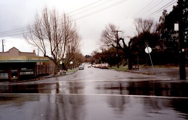
Photograph, 111-113 Union Road intersection with Windsor Crescent, 1985
There are earlier photos of this building both in this collection and one on the SLV website. James Sneddon's real estate business was an earlier occupant. Doubleday's occupied the site for nearly 3 decades. Later uses were as a kitchen showroom and a cafe.Colour photo taken on a wet winter's day showing Doubleday Real Estate Agents on the north eastern corner of the intersection. The opposite corner of Windsor Crescent is not visible. Rear in blue biro: "Union Road - Windsor Crescent". Handwriting not recognised. -
 Eltham District Historical Society Inc
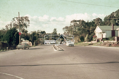
Photograph, Russell Yeoman, Intersection of Fitzsimons Lane with Main Road, Eltham, c.1969, 1969c
Shows intersection of Old Eltham RoadDigital file only; created from original colour positive slide transparencystreets, eltham, main road, fitzsimons lane, old eltham road -
 Eltham District Historical Society Inc
Negative - Photograph, Looking south along Ryans Road towards intersection with Kerrie Crescent, Eltham North, c.1998
Taken from opposite intersection with Elm CrescentRoll of 35mm colour negative film, 8 strips and associated 10 x 15 cm colour printKodak Gold 100-5elm crescent, eltham north, kerrie crescent, ryans road, streets -
 Melbourne Tram Museum
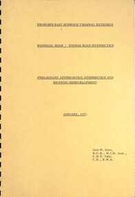
Document - Report, John Knee, "Warragul Road - Toorak Road Intersection", Jan. 1977
Report - "proposed East Burwood Tramway Extension - Warragul Road - Toorak Road Intersection - Preliminary Appreciation intersection and shopping redevelopment - Jan. 1977". Prepared by John W Knee for the MMTB and others. Looks at the intersection, how the shopping centre could be accessed, possible Mall development, residential issues, passenger facilities and pedestrian capacity. Includes a number of possible access routes for the area. None were applied when the tram line was extended.Yields information about a consideration for the extension of the Toorak Road line to East Burwood in 1977.Comb bound report with clear plastic covers, brown covers, 17 A4 pagesmmtb, east burwood, toorak road, warragul road, new tramways, john knee -
 Melbourne Tram Museum
Document - Report, Melbourne & Metropolitan Tramways Board (MMTB), "Intersection Improvement designs", 1973-1974
Report - Foolscap about red comb binder with card covers, 5 pages + 3 fold out plans - titled "Intersection Improvement designs" dated 1973 - 1974. Provides designs for intersections in Flemington Road and Elizabeth St to improve flow of trams, pedestrian safety and traffic flow. Drawing P14640 - Victoria and Elizabeth Sts P14684 - Flemington Road, Royal Parade and Elizabeth St (Haymarket Roundabout) P14600 - Royal Park Junction - Abbotsford St - Flemington RoadIn top right hand corner "D W Lees" in ink.trams, tramways, trackwork, royal park, abbotsford st, flemington road, elizabeth st, victoria st, junction, road works, traffic control, haymarket -
 Greensborough Historical Society
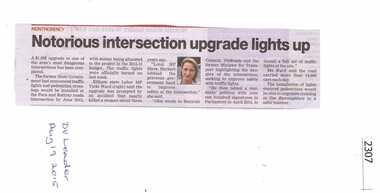
Newspaper Clipping, Notorious intersection upgrade lights up, 19/08/2015
A $1.5 million upgrade to the intersection at Para and Rattray Roads Montmorency includes traffic lights.News clipping, black text, colour image.para road, rattray road, montmorency -
 Ringwood and District Historical Society
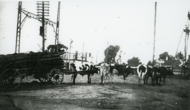
Photograph, Bullock team carting logs, on south side of Ringwood Railway Station near Bedford Road and Greenwood Avenue intersection - c.1930
Similar photo of same bullock team in archives (Lilian Burns Collection). Probably Paul Burns' rig, relative of Ron and Lilian Burns, Ringwood residents and RDHS members.Black and white laminated photo of bullock team carting logs, on south side of Ringwood Railway Station near Bedford Road and Greenwood Avenue intersection. +Additional Keywords: Burns, Paul / Burns, Ron / Burns, LilianCopyright Knox Historical Society -
 Wonga Park Community Cottage History Group
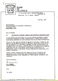
Work on paper (Item) - Letter, Wonga Park 1984 Letter from Shire of Lillydale to Wonga Park & District Residents' Association with four alternative intersection treatments
The Wonga Park and District Residents' Association requested the Shire of Lillydale consider removing the crests on Jumping Creek Road Wonga Park east and west of the intersection with Yarra and Dudley Roads to improve visibility at the intersection. The Shire of Lillydale thought that this would simply increase the speed of traffic through the intersection and suggested a roundabout be built and came up with four alternative treatments. When they discovered that a roundabout would require water mains to be lowered and the M&MBW would not give a quote on the cost (which would be substantial) they opted for traffic islands instead. -
 Eltham District Historical Society Inc
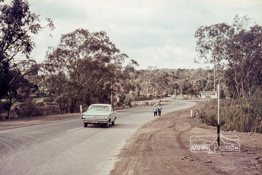
Photograph, Looking northeast along Main Road at intersection with Para Road, Lower Plenty, July 1969, 1969
House on right is 122 Main Road, Lower Plenty viewed from intersection of Main Road with Para Road35mm colour positive transparency blue Agfacolour Service plastic mountlower plenty, main road, para road -
 Stawell Historical Society Inc
Slide, Ian McCann, House butting into centre of Scallan and Byrne street intersection later demolished. Old Fire Station on right
This house was effectively in the middle of Scallan and Byrne Street intersection. Purchased by the council to be demolished c1975 to allow road to be aligned.House in centre of image. Old Fire Station on right looking down Scallan Street. -
 Ringwood and District Historical Society
Photograph, Canterbury Road looking east from west side of Heatherdale Road intersection up towards Cadbury. Ringwood January 1979
Written on back of photograph, "Jan. 79. Canterbury Road looking east from west side of Heatherdale Road intersection up towards Cadbury where road narrows down 3 to 1 lane. Before road widening." -
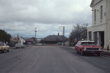
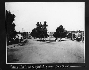 Stawell Historical Society Inc
Photograph, Stawell Hospital under construction looking from the Main Street and Wimmera Street intersection
View of Stawell Hospital under construction from Main Street and Wimmera Street intersection. Stawell Baths in centre of photo.stawell hospital -
 Eltham District Historical Society Inc
Photograph, Bendigo Tramways No. 2 en route from Quarry Hill outside the Victoria Hotel near the intersection of High Street at Victoria Street, Eaglehawk, January 1972, Jan 1972
Looking northwest across High Street, Eaglehawk at the intersection with Victoria Street. The Victoria Hotel is the present day New Victoria HotelDigital TIFF file Scan of 35mm Ilford FP3 black and white negative transparencybendigo, bendigo tramways no. 2, eaglehawk, eaglehawk mechanics institute, eaglehawk town hall, george coop collection, high street, loddon valley highway, milk bar, street new victoria hotel, pub, quarry hill, sailors gully road, tram, victoria hotel -
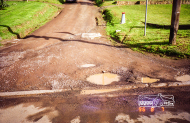
 Eltham District Historical Society Inc
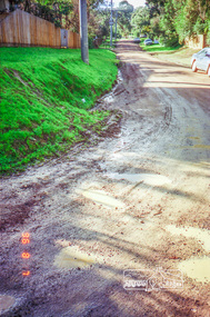
Photograph, Road surface conditions around Eltham: Looking east along Franklin Street from intersection with Bible Street, 7 Aug 1996, 1996
Shows sections of Franklin, John and Napoleon streets were still unmade as of late 1996 and the condition of those roads with potholes at the intersections with Bible Street.Reflects on the changing nature of the local street-scape and housesRoll of 35mm colour negative film, 7 stripsKodak Gold 100-5eltham, napoleon street, bible street, franklin street, john street -
 Eltham District Historical Society Inc
Photograph, Road surface conditions around Eltham: Looking east along Franklin Street from intersection with Bible Street, 7 Aug 1996, 1996
Shows sections of Franklin, John and Napoleon streets were still unmade as of late 1996 and the condition of those roads with potholes at the intersections with Bible Street.Reflects on the changing nature of the local street-scape and housesRoll of 35mm colour negative film, 7 stripsKodak Gold 100-5eltham, napoleon street, bible street, franklin street, john street -
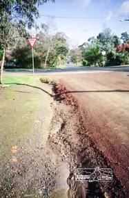
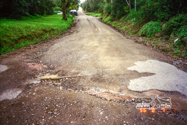
 Eltham District Historical Society Inc
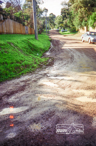
Photograph, Road surface conditions around Eltham: Looking west along Franklin Street at intersection with Bible Street, 7 Aug 1996, 1996
Shows sections of Franklin, John and Napoleon streets were still unmade as of late 1996 and the condition of those roads with potholes at the intersections with Bible Street.Reflects on the changing nature of the local street-scape and housesRoll of 35mm colour negative film, 7 stripsKodak Gold 100-5eltham, napoleon street, bible street, franklin street, john street -
 Eltham District Historical Society Inc
Photograph, Road surface conditions around Eltham: Looking west along John Street at the intersection with Bible Street, 7 Aug 1996, 1996
Shows sections of Franklin, John and Napoleon streets were still unmade as of late 1996 and the condition of those roads with potholes at the intersections with Bible Street.Reflects on the changing nature of the local street-scape and housesRoll of 35mm colour negative film, 7 stripsKodak Gold 100-5eltham, napoleon street, bible street, franklin street, john street -
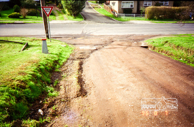 Eltham District Historical Society Inc
Photograph, Road surface conditions around Eltham: Looking east along John Street at the intersection with Bible Street, 7 Aug 1996, 1996
Shows sections of Franklin, John and Napoleon streets were still unmade as of late 1996 and the condition of those roads with potholes at the intersections with Bible Street.Reflects on the changing nature of the local street-scape and housesRoll of 35mm colour negative film, 7 stripsKodak Gold 100-5eltham, napoleon street, bible street, franklin street, john street -
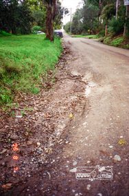
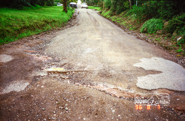 Eltham District Historical Society Inc
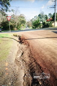
Photograph, Road surface conditions around Eltham: Napoleon Street looking east from intersection with Bible Street, 7 Aug 1996, 1996
Shows sections of Franklin, John and Napoleon streets were still unmade as of late 1996 and the condition of those roads with potholes at the intersections with Bible Street.Reflects on the changing nature of the local street-scape and housesRoll of 35mm colour negative film, 7 stripsKodak Gold 100-5eltham, napoleon street, bible street, franklin street, john street -
 Eltham District Historical Society Inc
Photograph, Road surface conditions around Eltham: Napoleon Street looking east from intersection with Bible Street, 7 Aug 1996, 1996
Shows sections of Franklin, John and Napoleon streets were still unmade as of late 1996 and the condition of those roads with potholes at the intersections with Bible Street.Reflects on the changing nature of the local street-scape and housesRoll of 35mm colour negative film, 7 stripsKodak Gold 100-5eltham, napoleon street, bible street, franklin street, john street -
 Stawell Historical Society Inc
Photograph, Panorama of Stawell from the top of St. Matthew’s Spire looking West with the Childe and Ligar Street intersection in the foreground
Panorama of Stawell from the top of St. Matthew’s Spire looking West. 502 School visible. Childe Street and Ligar Street intersection in foreground.stawell -
 Stawell Historical Society Inc
Photograph, Panorama of Stawell from the top of St. Matthew’s Spire with the Childe Street and Wimmera Street intersection on the right
Panorama of Stawell from the top of St. Matthew’s Spire. Childe Street and Wimmera Street intersection at right of photograph. Kings Buses in right corner.stawell, streetscape -
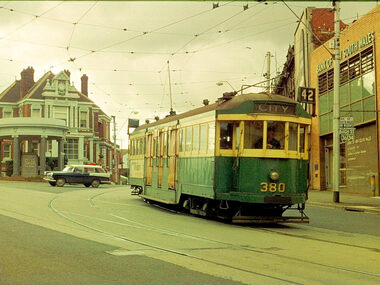 Melbourne Tram Museum
Photograph - Digital Image, Dick Jones, W2 380, at the intersection of High St and Mont Albert Road Kew, Sep. 1966
Digital image of W2 380, at the intersection of High St and Mont Albert Road Kew, Kew Junction. Kew Post Office is in the background along with a Bank of NSW building. Tram showing route 42, City. Photo by Dick Jones - reference - 380_KewPO_DickJones_6609x34Pe.11trams, tramways, w2 class, kew junction, route 42, mont albert rd, high st, tram 380 -
 Stawell Historical Society Inc
Photograph, Barnes and Scallan Streets intersection looking towards cemetery with Mr H Crouch's Undertaker Premises on the corner c1880's
Main Street Barnes and Scallan Streets intersection looking towards cemetery. H Crouch Undertaker on corner. Primary School 502 obscured by trees. 1880'sVictorian Views. C. Herbert, Photo. Stawell 1878stawell cemetry road -
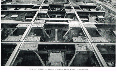 Melbourne Tram Museum
Photograph - Illustration, Melbourne & Metropolitan Tramways Board (MMTB), "Resilient crossings - Bourke Street - William Street Intersection", mid 1950's
Illustration, black and white, printed on gloss paper, reproduction of a MMTB report of photographs of the "Resilient crossings - Bourke Street - William Street Intersection", mid to late 1950's? May be from an MMTB Annual Report. Shows the nature of the crossing with the resilient inserts - it did not work as planned.trams, tramways, bourke st, william st, trackwork, construction -
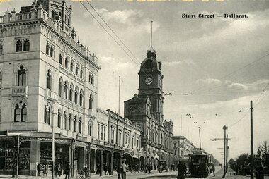 Ballarat Tramway Museum
Postcard, WTP, ESCo tram west bound at the intersection of Sturt and Lydiard St. Ballarat, c1906-7
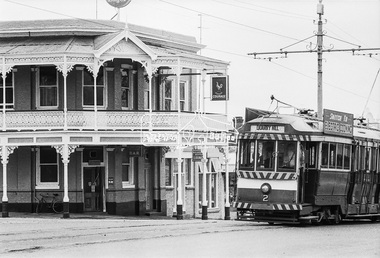
Printed black and white postcard of an ESCo tram west bound at the intersection of Sturt and Lydiard St. Ballarat, c1906 - 7 - has a destination box. Has a number of pedestrians in the picture. Taken from the east side of the intersection, looking towards the Town Hall, with the National Mutual Insurance building and Snows in the photo. Also shows the overhead arrangements - two wire for Sturt St, single for Lydiard St, coming into the intersection. Titled "Sturt Street, Ballarat" along the top edge. On rear of postcard are the words "Post Card", has initials "WTP" in bottom left hand corner, a 1d Victorian stamp, cancelled 1/5/07, stamp "5". Divided back type. Address to Mrs T.D. Cayett? Falcon St, North Sydney NSW. Note about their travels, where they stayed and that they had travelled to the Gardens by tram. See item 8237 for a coloured version. Black and white postcard - titled "Sturt Street Ballarat" - used 1907trams, tramways, esco, sturt st, postcards, town hall -
 Melbourne Tram Museum
Document, Yarra Trams, "Track Works intersection Camberwell & Toorak Roads", 9/2010
Document issued by Yarra Trams titled "Track Works intersection Camberwell & Toorak Roads", dated 16/9/2010 about trackworks, replacement temporary bus stops and rostered staff while work was carried out over the weekend of 18 and 19/2010. Signed by David Coverdale.Demonstrates an Yarra Trams notice regarding track works and replacement services.Document - 5 A4 printed sheetsyarra trams, trawmays, instructions, notices, track work, camberwell road, toorak road -
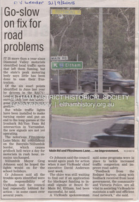 Eltham District Historical Society Inc
Document - Property Binder, Intersection of Main Road and Fitzsimons Lane, Eltham
Newspaper article: Go-slow on fix for road problems, Diamond Valley Leader, 21 September 2005, covering delay re traffic problems Ironbark Road ,Yan Yean Road, Fitzsimons Lane, Main Road roundabout. Fitzsimons Lane Upgrade, Community Update, June 2022, Major Road Projects Victoria, includes detail on landscaping at Main Road intersection.main road, eltham, property, fitzsimons lane, traffic, edendale community farm, eltham high school, landscape, major road projects victoria, porter street, roundabout, yellow box gum