Showing 60 items
matching jack lundy
-
 Ringwood and District Historical Society
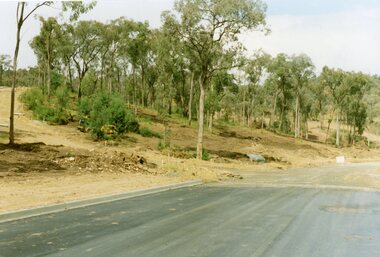
Photograph, Corner of Pamela Court and Kubis Drive, North Ringwood, looking west on 3rd November 1978
... and Glenvale Road. From the Jack Lundy Clarke collection...., Manuelo Drive, Iluka Place and Glenvale Road. From the Jack Lundy ...E551 N15 Part of a 51-photo record of the development of the "Kubis" Estate, Ringwood North, including road works to Debbie Place, Kubis Drive, Werac Drive, Manuelo Drive, Iluka Place and Glenvale Road. From the Jack Lundy Clarke collection. -
 Ringwood and District Historical Society
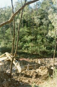
Photograph, Looking west across Werac and Kubis Drives, North Ringwood, in April 1978. Loughnan's Lake site. The retaining wall was where the truck tracks disappear over thhe ridge. The spillway was at that spot
... and Glenvale Road. From the Jack Lundy Clarke collection...., Iluka Place and Glenvale Road. From the Jack Lundy Clarke ...E548 N3 Part of a 51-photo record of the development of the "Kubis" Estate, Ringwood North, including road works to Debbie Place, Kubis Drive, Werac Drive, Manuelo Drive, Iluka Place and Glenvale Road. From the Jack Lundy Clarke collection. -
 Ringwood and District Historical Society
Photograph, Kubis Drive and Debbie Place, North Ringwood, on 3rd November 1978, looking east
... and Glenvale Road. From the Jack Lundy Clarke collection.51..., Manuelo Drive, Iluka Place and Glenvale Road. From the Jack Lundy ...E551 N13 Part of a 51-photo record of the development of the "Kubis" Estate, Ringwood North, including road works to Debbie Place, Kubis Drive, Werac Drive, Manuelo Drive, Iluka Place and Glenvale Road. From the Jack Lundy Clarke collection.51 -
 Ringwood and District Historical Society
Photograph, Looking from Werac Drive, North Ringwood, on 14th April 1978, across the site of the headwaters of Loughnan's Lake. Main body of water lay to the left (west)
... and Glenvale Road. From the Jack Lundy Clarke collection.51..., Iluka Place and Glenvale Road. From the Jack Lundy Clarke ...E548 N7 Part of a 51-photo record of the development of the "Kubis" Estate, Ringwood North, including road works to Debbie Place, Kubis Drive, Werac Drive, Manuelo Drive, Iluka Place and Glenvale Road. From the Jack Lundy Clarke collection.51 -
 Ringwood and District Historical Society
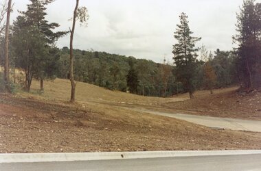
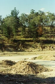
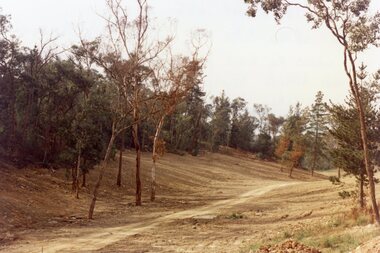
Photograph, Looking west from Kubis Drive, North Ringwood, in April 1978, over the full length of the site of Loughnan's Lake
... and Glenvale Road. From the Jack Lundy Clarke collection.51..., Iluka Place and Glenvale Road. From the Jack Lundy Clarke ...E548 N5 Part of a 51-photo record of the development of the "Kubis" Estate, Ringwood North, including road works to Debbie Place, Kubis Drive, Werac Drive, Manuelo Drive, Iluka Place and Glenvale Road. From the Jack Lundy Clarke collection.51 -
 Ringwood and District Historical Society
Photograph, Looking up Debbie Place, North Ringwood, on 3rd November 1978, that has box sheet of metal
... and Glenvale Road. From the Jack Lundy Clarke collection.51..., Manuelo Drive, Iluka Place and Glenvale Road. From the Jack Lundy ...E551 N14 Part of a 51-photo record of the development of the "Kubis" Estate, Ringwood North, including road works to Debbie Place, Kubis Drive, Werac Drive, Manuelo Drive, Iluka Place and Glenvale Road. From the Jack Lundy Clarke collection.51 -
 Ringwood and District Historical Society
Photograph, Kato digging the 27-foot for the well at the pumping planty at Glenvale Road, North Ringwood, on 10th June 1978
... and Glenvale Road. From the Jack Lundy Clarke collection.51..., Iluka Place and Glenvale Road. From the Jack Lundy Clarke ...E550 N4 Part of a 51-photo record of the development of the "Kubis" Estate, Ringwood North, including road works to Debbie Place, Kubis Drive, Werac Drive, Manuelo Drive, Iluka Place and Glenvale Road. From the Jack Lundy Clarke collection.51 -
 Ringwood and District Historical Society
Photograph, Looking north from between Werac and Kubis Drives, North Ringwood, in February 1978
... and Glenvale Road. From the Jack Lundy Clarke collection.51..., Iluka Place and Glenvale Road. From the Jack Lundy Clarke ...E546 N3 Part of a 51-photo record of the development of the "Kubis" Estate, Ringwood North, including road works to Debbie Place, Kubis Drive, Werac Drive, Manuelo Drive, Iluka Place and Glenvale Road. From the Jack Lundy Clarke collection.51 -
 Ringwood and District Historical Society
Photograph, Leaving Debbie Place, North Ringwood, now ready for metalling on 3 November 1978
... and Glenvale Road. From the Jack Lundy Clarke collection.51..., Manuelo Drive, Iluka Place and Glenvale Road. From the Jack Lundy ...E551 N12 Part of a 51-photo record of the development of the "Kubis" Estate, Ringwood North, including road works to Debbie Place, Kubis Drive, Werac Drive, Manuelo Drive, Iluka Place and Glenvale Road. From the Jack Lundy Clarke collection.51 -
 Ringwood and District Historical Society
Photograph, The Kato working on the pumping plant at the end of the sewer trench near Glenvale Road, North Ringwood, on 10 June 1978. Loughnan's Lake site shown as a grassy hollow in the background
... and Glenvale Road. From the Jack Lundy Clarke collection.51..., Manuelo Drive, Iluka Place and Glenvale Road. From the Jack Lundy ...E550 N2 & N3 Part of a 51-photo record of the development of the "Kubis" Estate, Ringwood North, including road works to Debbie Place, Kubis Drive, Werac Drive, Manuelo Drive, Iluka Place and Glenvale Road. From the Jack Lundy Clarke collection.51 -
 Ringwood and District Historical Society
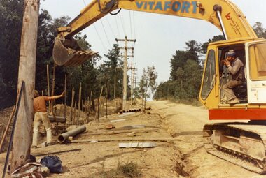
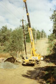
Photograph, The Kato working in Glenvale Road, North Ringwood, in April 1978. Laying pipes from the MMBW
... , Iluka Place and Glenvale Road. From the Jack Lundy Clarke... the Jack Lundy Clarke collection.51 The Kato working in Glenvale ...E548 N37, N39 & N41 Part of a 51-photo record of the development of the "Kubis" Estate, Ringwood North, including road works to Debbie Place, Kubis Drive, Werac Drive, Manuelo Drive, Iluka Place and Glenvale Road. From the Jack Lundy Clarke collection.51 -
 Ringwood and District Historical Society
Photograph, SEC poles going up in Glenvale Road, North Ringwood, on 14 May April 1998
... , Iluka Place and Glenvale Road. From the Jack Lundy Clarke... the Jack Lundy Clarke collection.51 SEC poles going up in Glenvale ...E548 N37, N39 & N41 Part of a 51-photo record of the development of the "Kubis" Estate, Ringwood North, including road works to Debbie Place, Kubis Drive, Werac Drive, Manuelo Drive, Iluka Place and Glenvale Road. From the Jack Lundy Clarke collection.51 -
 Ringwood and District Historical Society
Photograph, View up the gully from Glenvale Road, North Ringwood towards the spot of the wall of Loughnan's Lake was
... and Glenvale Road. From the Jack Lundy Clarke collection.... the Jack Lundy Clarke collection. View up the gully from Glenvale ...The brown undergrowth is on the remains of the walls, since levelled. Circa 1979. Part of a 51-photo record of the development of the "Kubis" Estate, Ringwood North, including road works to Debbie Place, Kubis Drive, Werac Drive, Manuelo Drive, Iluka Place and Glenvale Road. From the Jack Lundy Clarke collection. -
 Ringwood and District Historical Society
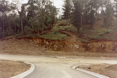
Photograph, Kubis Estate, North Ringwood in April 1978. View of the lake site looking east. The wall was where the track bends. The rope tree was on the hillside beyond the track bend
... and Glenvale Road. From the Jack Lundy Clarke collection...., Manuelo Drive, Iluka Place and Glenvale Road. From the Jack Lundy ...E548 N35 This photo was taken from almost the same spot as the 1976 one. Part of a 51-photo record of the development of the "Kubis" Estate, Ringwood North, including road works to Debbie Place, Kubis Drive, Werac Drive, Manuelo Drive, Iluka Place and Glenvale Road. From the Jack Lundy Clarke collection. -
 Ringwood and District Historical Society
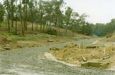
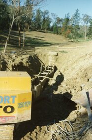
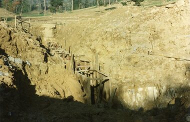
Photograph, Kubis Estate, North Ringwood on 10 June 1978. Trench for sewer below the manhole
... and Glenvale Road. From the Jack Lundy Clarke collection.... the Jack Lundy Clarke collection. Kubis Estate, North Ringwood ...E550 N7 The hole for the 27 feet deep well shows as a white patch, lower right. Part of a 51-photo record of the development of the "Kubis" Estate, Ringwood North, including road works to Debbie Place, Kubis Drive, Werac Drive, Manuelo Drive, Iluka Place and Glenvale Road. From the Jack Lundy Clarke collection. -
 Ringwood and District Historical Society
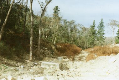
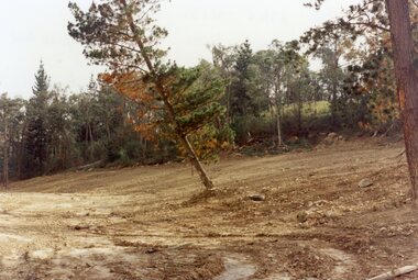
Photograph, Site of Loughnan's Lake, North Ringwood in April 1978
... , Werac Drive, Iluka Place and Glenvale Road. From the Jack Lundy... and Glenvale Road. From the Jack Lundy Clarke collection. Site ...E548 N33 The leaning pine tree grew on the lake shore after 1950. It also was used as a rope tree by the children. Part of a 51-photo record of the development of the "Kubis" Estate, Ringwood North, including road works to Debbie Place, Kubis Drive, Werac Drive, Iluka Place and Glenvale Road. From the Jack Lundy Clarke collection. -
 Ringwood and District Historical Society
Document, Packet: Flora of Ringwood - reports lists and notes 1930s onwards, plus clipping 1853
... . . Correspondence between Jack Lundy, Mrs Pullin and Bryan Tonkin re bulbs... area dated August 1994. . Correspondence between Jack Lundy ...Packet containing miscellaneous articles and correspodence.Packet includes: . Letter from Maroondah Group for the Society for Growing AustraliannPlants to Ringwood Council outlining objections to development of Glenvale Road area from flora and fauna aspects. Dated 17/7/94. Report by Eva Buchanan on proposed subdivision 94/112- Glenvale Road area dated August 1994. . Correspondence between Jack Lundy, Mrs Pullin and Bryan Tonkin re bulbs. . Miscellaneous documents on the Flora of Ringwood. . Typed notes- Eucalypts of Ringwood, Plants and Fungi of Ringwood, Birds of Ringwood area, Plants of Mitcham area, Wattles of Ringwood. (Refer also to "Ringwood- Place of Many Eagles" book, Appendix IV: Ringwood Natural History by F.J.C. Rogers, pages 241 to 268). -
 Murrumbeena Cricket Club
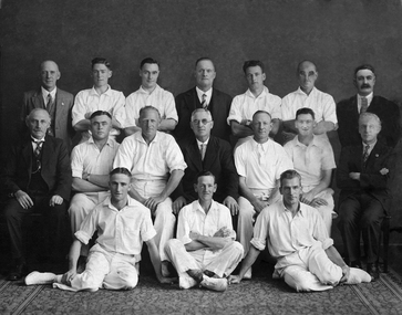
Photograph, 1934-35 B Team Premiership, c.1935
Photograph of 1934-35 B Team premiershipmurrumbeena, murrumbeena cricket club, cricket, cricket clubs, cricketers, ernie frankland, peter robertson, percy love, jim watson, jack ridgeway, stan francis, fred glenie, edwin robertson, m hanley, g fulling, arthur schrape, george eakins, alex lundy, t j riley, lew bristowe, wally gray, js murray, don taylor -
 Murrumbeena Cricket Club
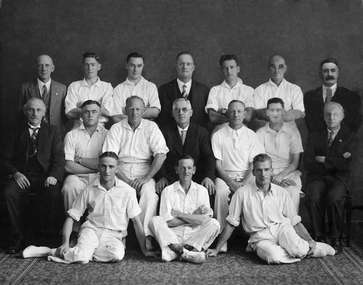
Photograph, 1935-36 B Team Premiership, c. 1936
Photograph of 1935-36 B Team premiershipmurrumbeena, murrumbeena cricket club, cricket, cricket clubs, cricketers, charlie parker, h (bert) evans, edwin robertson, percy love, h vaughan, g fulling, jack ridgeway, peter robertson, roy bailey, lew bristowe, t j riley, roy moore, alex lundy, jim watson, harry waters, george eakins, wally gray -
 Mt Dandenong & District Historical Society Inc.
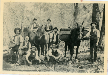
Photograph, Clint Rowse and Staff
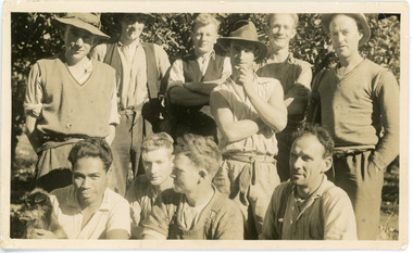
John Lundy-Clarke grew up in the Kalorama/Mt Dandenong area and later in life (1972-74) began to write a comprehensive history of the area working from an original settlement map in an effort to cover all areas. John Lundy-Clarke has identified the photograph as being of Clint Rowse and Staff at Olinda Creek Valley in 1939. The workmen are: Back row from right: Bob Daly, Dud Page, Harry Dyson, Bill Cavell, Len Child, Ken Williams. Front row from right: Clint Rowse, Jack Clarke, Bernie Page, Jack Johnson (with dog). The Rowse family had extensive raspberry crops but later changed to flowers. Daisy Rowse married Hubert Jeeves. Black and white photograph showing a group of 10 workmen, one holding a dog.The names Lenny Child, Dyson, Page, Bob Daly, Jackie Johnston, J Clarke, Clint Rowse are handwritten on the back by John Lundy-Clarkelen child, bob daly, clint rowse, jack johnston, bill cavell, ken williams, jack clarke, dud page, bernie page -
 Mt Dandenong & District Historical Society Inc.
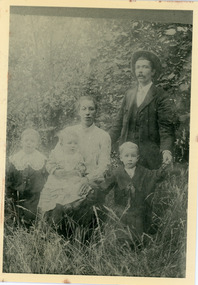
Photograph, Jack Dodd of Olinda, Wife and Sons
... description by John Lundy-Clarke. Jack Dodd of Olinda, Wife and Sons ...Posed photograph taken on verandah of house showing Jack Dodd with his wife and sons. Reverse of photograph has handwritten description by John Lundy-Clarke.Jack Dodd of Olinda, Wife and their sons.jack dodd -
 Mt Dandenong & District Historical Society Inc.
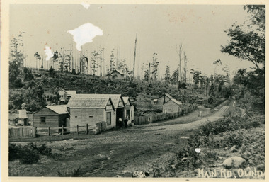
Photograph, Main Street Olinda c1908
c1908 view of Main Street Olinda with Dodd's store in foreground and Olinda State School up on the hill. Reverse of photograph has handwritten description by John Lundy-Clarke.Photo of Olinda taken about 1908 showing State School on skyline. Dodd’s store in foreground. Hodges blacksmith shop on roadside right. Coonara Road, then Mernda Road leads up out the picture right, Mt Dandenong Road goes down left. Range Road (the bullock track) is in immediate foreground and Sassafras turns to the right before the visible tracks on Mernda Road.olinda, jack dodd, general store, school -
 Mt Dandenong & District Historical Society Inc.
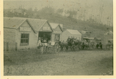
Photograph, Dodd's Store and Coaches c1909
Hazy view of Jack Dodd's Store in Olinda's Main Street with carts in front c1909. Reverse of photograph has handwritten description by John Lundy-Clarke.Dodd’s store Olinda 1905? With his butcher’s cutting cart leading the line of coaches in the Bayswater Sassafras Olinda run.jack dodd, general store, coach, butcher -
 Mt Dandenong & District Historical Society Inc.
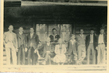
Photograph, Pioneer Settlers Of Olinda
Group photo of pioneer settlers of Olinda. Jack Dodd is shown RHS holding the rein of his packhorse 'Darkie". The descriptive text on the reverse of this photograph was hand written by John Lundy-Clarke.Pioneer settlers of Olinda. Jack Dodd with the packhorse.jack dodd, dodd, packhorse, olinda, horse, settlers -
 Mt Dandenong & District Historical Society Inc.
Photograph, Jack Dodd of Olinda With Family 1904, c1904
... -and-the-dandenong-ranges Jack Dodd George Dodd Alan Dodd Guy Dodd Fred Dodd ...Jack Dodd, son of George Dodd with his wife and children Alan (eldest), Fred and Guy. c1904. The descriptive text on the reverse of this photograph was hand written by John Lundy-Clarke.Jack Dodd and wife nee Thomas with children Alan the eldest, Fred and Guy.jack dodd, george dodd, alan dodd, guy dodd, fred dodd, olinda -
 Mt Dandenong & District Historical Society Inc.
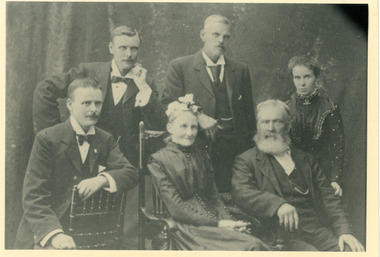
Photograph, The Park Family of Olinda
Formal photograph of the Park family who took up Lot 16, Section 3 of the Mooroolbark Village Settlement. L - R are George, Jack, Mrs Park (Elspeth), Will, Mr Park, Mary (Mrs McGowan). The descriptive text on the reverse of this photograph was hand written by John Lundy-Clarke.The Park Family of Olinda L to R George Jack Mrs Park (Elspeth) Will Mr Park Mary (Mrs McGowan) george park, will park, jack park, park family, elspeth park, mary park, mary mcgowan, olinda -
 Mt Dandenong & District Historical Society Inc.
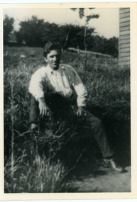
Photograph, Hubert Child
Bert Child son of Francis Matthew father of Jack, Bert and Len. Husband of Maria Madden. Died 1926.Black and white photograph of Bert Child as a young man. He is sitting in the grass near a wooden building. This photograph has a detailed inscription on the back handwritten by John Lundy-Clarke.Bert Child son of Francis Matthew father of Jack, Bert and Len. Husband of Maria Madden. Died 1926.bert child, hubert child, francis matthew child, maria madden, kalorama -
 Mt Dandenong & District Historical Society Inc.
Photograph, Post Office and 'Mountjoy', Mt. Dandenong North, 1913
Rose Series post card #182Copy of Rose Series postcard #182 showing Kalorama Gap in 1913. Haystacks in foreground with Mountjoy Guest House and Beulah Tea Rooms/Mt Dandenong North Post Office in centre. This photograph has a detailed inscription on the back handwritten by John Lundy-Clarke in 1974.Kalorama Gap in 1913 The elm trees are in the centre of the picture. One of these is really two as two suckers of the further tree were twisted together by Fred Jeeves in 1898 and grew as one tree. The other was planted in 1880. The shop is the shop of Mrs Eliza Hand and daughter Florence. The closed in far end of the verandah was the Mount Dandenong North Post Office. The large house is “Mountjoy” owned and run by the Jeeves Family from 1908 till 1943. It was built in 1905 by the Paynters who sold to Ellis Jeeves in 1908.He moved his line of coaches from “Kalorama” his old homestead and housed the horses in a line of stables behind “Mountjoy”. Price’s house, which contained their shop, the first one on the mountain, opened 1906, can be seen faintly behind the pine tree opposite the bend in the road, which was the main road then and now is Ridge Road. The Price’s house just shows in two tiny pieces, one on each side of the pine tree half way up. The house to the right of and high up the pine tree is Walker’s cottage which exists today opposite Jack Kidd’s home at the far edge of Lt 2 Village Settlement and was between Main Road and Barbers Road which runs down the left behind the elms. Walker’s homestead can be seen near left edge of picture 2/3 way up. The roof of the Methodist Church shows among trees left of picture. This, like Mrs Hand’s shop was built on portions separated from Isaac Jeeves’ Selection “C” known as Jeeves Saddle. kalorama gap, five ways, mountjoy, john lundy-clarke, beulah tea rooms, post office, fred jeeves, paynter, jeeves, frederick jeeves, price, walker, jack kidd -
 Mt Dandenong & District Historical Society Inc.
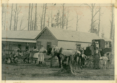
Photograph, 'Callum House' - Bill Farndon's Guest House 1911, 1911
Front view of Callum House located on the corner of Falls and Farndons Roads. Built by Bill Farndon. In the background are trees killed by bushfires in 1897. There is a horse and buggy in the foreground. Figures standing have been identified as (from LHS) Jim Clarke, Len Farndon, Jack Clarke, Essie Farndon, Rhoda farndon, Doug Farndon, Mrs Farndon. Driver is Bill Campbell. This photograph has a detailed inscription on the back handwritten by John Lundy-Clarke in 1974.1911 “Callum House” Farndon’s guest house corner of Fall’s and Farndon’s Roads. Later “Bonvenu” and again “The Oaks”. Showing the trees killed by bushfires in 1897. Figures standing are from left – Jim Clarke, Len Farndon, Jack Clarke, Essie Farndon, Rhoda Farndon, Doug Farndon, Mrs. Farndon. Bill Campbell driving.callum house, benvenu, the oaks, essie farndon, bill farndon, rhoda farndon, bill campbell, jim clarke, jack clarke, doug farndon -
 Mt Dandenong & District Historical Society Inc.
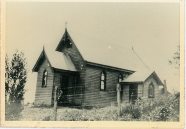
Photograph, Church of England, Olinda
Church of England. Monash Avenue, Olinda. The descriptive text on the reverse of this photograph was hand written by John Lundy-Clarke.Church of England Olinda When the church was built it faced on to the main Mt Dandenong Road but the road was deviated in and the main road section in front of the Village Settlement blocks was named Monash Avenue. The chapel built on Mrs Warner’s land on Mernda Road (later Coonara Road) was shifted in 1936 by Dick Mitlan using Jack Clarkes Ford truck as traction plant. church of england, olinda, monash avenue